Saturday, May 5, 2012

Cloudy, Cooler, Quiet...

Good Morning!


We have some clouds in the area, and some rain moving into Michigan from off the lake, though I don't think we'll see anything here in the South Central Michigan Weather Zone.  If we do, there won't be much to it.  Let's put on the swim gear and take a deeper dive:


TEMPERATURES:  We'll see temperatures retreat to the seasonable if a bit cool regime for the next several days from the 80+ readings we had Thursday.  Temperatures will spend most of their days in the 60's to mid 70's, with mid 40's at night.  In fact, that pattern looks to hold through next week, if the modeling is right.  Sunday will be the warmest day of the next six as it stands now, climbing into the mid 70's - after that, we'll be in that 60-73 degree range I mentioned above.


RAIN:  A different look at total rainfall for the next five days from the National Weather Service, as the expected five day rain totals have been chopped WAY down.  All of Michigan is now expected to see an inch or less of rain between now and Wednesday - quite a bit different from prior forecast runs.  Here's the map showing the NWS idea of how wet we get the next five days:


Accordingly, any shower mentions we do put in the forecast that actually pan out won't amount to a whole lot.  It looks like the best chance of rain the next six days will be Monday into Tuesday.  A couple more model runs should nail that down for us.


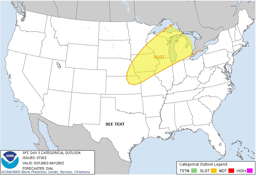
SEVERE WEATHER:  Of the next three days, tomorrow is the only day with any risk category defined for Michigan from the Storm Prediction Center, and that's just the "general" risk for plain ol' everyday thunderstorms.  Here's a look at the SPC forecast maps for today and tomorrow, valid at 8AM as usual.


 Today
Tomorrow


Relatively calm and quiet here, the rough stuff stays south and west of us for the next few days.


Here's a little bit different look for you today at what's going on currently.  This is the current visible satellite image, with the NEXRAD radar composite reflectivity product layered on top of it.  So you can see where the clouds are and where it's raining in one image...


And here's the local forecast for Jackson and surrounding communities including Grass Lake and Parma.


For today, mainly cloudy skies with a couple of peeks at sunshine, a chance of an isolated shower, high temperature of 70, winds ENE 7-15 MPH.


Tonight, more clouds than stars, cool, nighttime lows roll all the way back to 45, winds ESE 5-10 MPH.


Sunday, mainly clear skies with a few passing clouds that increase during the afternoon, seasonable and pleasant, high temperatures near 73, winds ESE 7-15 MPH.


Sunday night, clouds keep thickening until we get to mostly cloudy skies, a touch warmer overnight as the clouds blanket the daytime heat, lows down to around 47, winds ESE 5-10 MPH.


Monday, mostly overcast skies with a glimpse or two of sun, scattered to numerous showers move in later in the evening, high near 70, winds ESE 10-15 MPH.


Tuesday, clouds persist, a chance of scattered showers, high only 67.


Wednesday, a few peeks of sunshine break up an otherwise cloudy day, a few lonely showers are possible, cooler with a high of only 62.


Thursday, clouds finally vacate the area for awhile, leaving us clear and pleasant, high temperature 66.


Friday, sunny, seasonable, splendid, lots of blue skies with a high temperature of 70.


There's a look at your forecast for the next six days in the South Central Michigan Weather Zone, I do hope you have a wonderful Saturday!  Blessings.

Friday, May 4, 2012

Still Damp, But Cooler...

Good Morning!

It looks like the stormy weather that we have had the last 12 hours or so will be in the way out of here, at least for awhile, as we settle into more stable cooler air.

SEVERE WEATHER:  We had plenty of it to go around yesterday and last night.  Several reports of large hail, including 2 inch hail in Jackson County, and some more in Washtenaw.  Thank goodness, no tornadoes were reported.  Currently just some light shower activity with a  couple of embedded storms near Flint, Hastings, and Ionia this hour.

The Storm Prediction Center has quite a bit more "slight" risk territory in the mix this morning, but we are not currently a part of it.  Pretty much all of Illinois, Indiana, Iowa, Nebraska, and a good chunk of South Dakota are in the "slight" risk area.  The southern half of lower Michigan is in the "general" risk category, so any storms that fire today should be just the garden variety storms.  Showers and a few storms have been firing persistently all night long along the I-96 corridor, and as the day progresses that line will slowly continue dropping south through the state.  On the north side of that in the cooler, more stable air, storms are less likely to fire.

Here's the risk maps from SPC, each valid at 8AM as always.
Day 1
Day 2
I didn't include Day 3 which is Sunday, because the risk is well away from Michigan, over southwest Illinois, Missouri, Kansas, and Oklahoma.

RAIN:  Most areas got a good soaking of rain yesterday with the storms moving through.  There are some Flash Flood watches up for another couple of hours, and one warning, in Shiawassee County, until 9AM.

The National Weather Service is saying we'll get pretty wet over the next five days, and based on the modeling, this looks like a pretty good bet.  We'll see rain taper off midday today, then a small chance of rain for Cinco De Mayo, and again to start the new week.  It looks like Monday will be the next day with a solid chance for rain.  Here's the latest map showing an inch and a half of rain for the next five days as the lowest total in the area:

TEMPERATURES:  The forecast for the next few days is much cooler on the backside of this front that is bringing the rain.  You knew the storms were going to be strong with an almost 20-degree temperature swing between the warm and cool sides of the front.  Mid 80's were the rule around much of South Central Michigan yesterday, today we'll warm back into the middle 70's in most spots today.  Here's a look at temperatures around the US at this hour, and the local Grand Rapids NEXRAD radar image, showing some showers and embedded thunder up around Grand Rapids, west to the lake shore:


And here's the local forecast:


Today, mainly cloudy skies, perhaps a peek or two of sun, showers and thunderstorms should taper off by lunchtime but could re-develop this evening, high near 77, SW winds turning N 10-15 MPH.


Tonight, cloudy skies, a chance of a scattered shower or thunderstorm, lows down to 52 with ENE winds 7-14 MPH.


Saturday, mostly cloudy skies, with a few sunshiny breaks in the clouds, cooler, high near 72, winds E 10-15 MPH.


Saturday night, cloudy skies, cooler, nighttime lows drop to around 47, winds ENE 5-10 MPH.


Sunday, a mix of clouds and sunshine, cooler, high near 68, ESE winds 7-12 MPH.


Monday, mainly cloudy, seasonable, chance of scattered showers or a roaming thunderstorm, high near 70.


Tuesday, mostly cloudy skies, cooler, chance of scattered showers, high near 66.


Wednesday, cloudy skies, cool, chance of widely spaced showers, high only 60.

There's a look at your forecast the next 5 days, I do hope you have a wonderful Friday!  Blessings.

Thursday, May 3, 2012

Severe Thunderstorm Warning Washtenaw County...

until 11:30 PM for the storm that produced 2 inch hail in Jackson County at around 10:20 PM  Cities under the gun include:

Manchester and Chelsea, 10:45PM
Pleasant Lake 10:55PM
Saline 11:10PM
Ann Arbor 11:15PM

Severe Thunderstorm Warning Jackson County...

Until 10:45 PM, for this storm that can produce 60+ MPH winds and golf ball sized hail...


2 inch hail reported with this storm, which is expected to move though Grass Lake next!

Significant Weather Advisory, Calhoun and Jackson Counties

...SIGNIFICANT WEATHER ADVISORY... 

AT 908 PM EDT...NATIONAL WEATHER SERVICE DOPPLER RADAR INDICATED 
STRONG THUNDERSTORMS ALONG A LINE EXTENDING FROM NEAR MARENGO TO 
KEKONSHA...MOVING EAST AT 40 MPH. 

ONE HALF INCH DIAMETER HAIL...WINDS GREATER THAN 40 MPH...BRIEF HEAVY 
DOWNPOURS...ARE POSSIBLE WITH THESE STORMS. 

LOCATIONS IMPACTED INCLUDE... 
SPRINGPORT... ALBION... PULASKI... 
PARMA... CONCORD... TOMPKINS... 
SANDSTONE... SPRING ARBOR... HANOVER... 
HORTON... RIVES JUNCTION... LIBERTY TWP... 
JACKSON... VANDERCOOK LAKE... CLARK LAKE... 


PRECAUTIONARY/PREPAREDNESS ACTIONS... 

GUSTY WINDS MAY CAUSE SMALL OBJECTS SUCH AS TRASH BINS TO BLOW 
AROUND. SEEK SHELTER IN A STURDY STRUCTURE UNTIL THESE STORMS HAVE 
PASSED. 
Gust Front Alert - Washtenaw County
Every county in the S. Central MI Weather Zone is under a Severe T-Storm Watch until 9PM except Branch, Hillsdale, Lenawee and Washtenaw.
Flash Flood Watch posted - Clinton, Eaton, Ingham, Calhoun, Jackson counties through Friday 5/4 8AM EDT.

Feelin' Like May...

Good Morning!


We caught a break yesterday, as far as a severe weather goes.  Most of the ingredients were in place for severe weather to fire in the late afternoon into the early evening hours, and then everything just sort of fizzled and we remained bone dry, then cleared off to boot.  For my money, the cap held.  We'll talk about that in a separate post.  It looks like we're in a similar situation today, but we'll have to see if the cap holds tough again, or if it weakens enough to allow storm development.  Quite a show going on up to the north of us right now, as strong storms are making their way through the northern half of the Lower Peninsula.  Look at this infrared satellite image:


And this is a radar image from the Grand Rapids NEXRAD taken a bit earlier this morning...


Now, let's take a deeper dive:


SEVERE WEATHER: The current set of severe weather outlooks from the Storm Prediction Center has us with a "slight" risk for severe storms today, and it looks like any strong storms will be confined to the north zone, especially north of I-96. Here's a look at the maps, each one valid at 8AM as always.  This is today...


Day two we fall back into the "general" risk category...


No risk at all on Day 3...


From the looks of it, the primary threat from severe storms would be strong wind and hail, as opposed to tornadoes, but I don't want to take that totally off the table, as there's nothing to say that a quick spin-up tornado couldn't form inside a severe storm.


RAIN:  Still a pretty wet look, with the National Weather Service forecasting two inches or better for most of the state.  I don't think we get that much here in the blog area, I would say an inch to an inch and-a-quarter tops over the next five days.  Computer models are known to have a hard time nailing down rain totals in this type of weather pattern, and it depends so much on where thunderstorms fire, and whether they are high precipitation or low precipitation storms (yes there's a difference!).  Anyhow, here's the 5 day rain map from the National Weather Service:


TEMPERATURES:  We'll be in a warm summer-like pattern for another day or so, then we start to cool things down, rolling back into the more seasonable 70's.  We'll get into the 80's again today throughout most places the blog covers, with broken sunshine.  The GFS and NAM  like 86 and 84 respectively, so we'll split the difference and call it 85 in Jackson, and the models indicate a high of 83 sounds right for Lansing.  The warm air dome is making his presence felt, that's for sure!  Here's a look at current temperatures around this great nation...


Look at those 60's and 70's at 6:30AM, you can see pretty well where the warm air dome is already!


And here's the local forecast for Jackson County:


For today, periods of clouds and sunshine, warm and a little humid, a chance of scattered afternoon showers and thunderstorms, especially as you go north, high temperature 85, winds SW 10-20 MPH.


Tonight, mainly starry skies, some clouds could bring an isolated or widely scattered nighttime shower or storm, lows near 60, winds SW 7-15 MPH.


Friday, mainly cloudy skies, not quite as warm, a chance of widely scattered showers and thunderstorms, high near 80, SW winds 10-20 MPH.


Friday night, cloudy skies early with a chance of an isolated shower, then clearing a bit late, lows near 60, wind ENE 7-14 MPH.


Saturday, cloudy skies with a peek or two of sunshine, a chance at a scattered shower or storm, high of 71.


Sunday, clear skies and pleasant, high near 73.


Monday, cloudy skies with a chance of showers and thunderstorms, high near 75.


Tuesday, cloudy skies and a chance of scattered showers or thunderstorms, high near 72.


There's a look at your forecast for the next 6 days, I do hope you have a great day!  Blessings. 

Wednesday, May 2, 2012

The Storm Prediction Center is watching South Central MI closely and considering issuing a weather watch soon, as severe weather ingredients continue to fall in line, keep checking here, Facebook and Twitter for details.

Foggy, Stormy...

SEVERE WEATHER:  It looks like the Spring pattern for strong to severe weather is settling into the Midwest, and South Central Michigan is part of it.  We are under the gun for storms the next three days according to the Storm Prediction Center, with a "slight" risk each day.  Here's the maps.  Each one is valid at 8AM as always.  


We'll have a fairly active and stormy pattern the next few days I think.  Take a look at that "moderate" risk out in Iowa and Nebraska for today - the chasers are already converging on that spot.  We already have a line of strong thunderstorms coming on shore from Lake Michigan now. Fortunately there are no severe watches with those, and this is a linear system.  Out front, strong thunderstorms that will dump a a lot of rain, blow hard on you, and maybe have some hail.. Behind that in the rain cooled air, just showers.


RAIN:  We'll see plenty of that as well.  In fact, a line of strong thunderstorms is making it's way on shore right now from Lake Michigan, and they are bringing some good rain along with them.  Here's what the National Weather Service thinks regarding total rain for the next 5 days.


I will forego the temperature discussion today due to work commitments, and go straight to the local forecast for Jackson County, but here's a look at the satellite image right now.  Strong stuff off to the north of us.  Based on the way things are shaping up now, we should see at least a taste of it later.


Forecast goes like this:


For today, mostly cloudy with a few peeks of sunshine, chance of scattered to numerous showers and thunderstorms, any that fire could be strong or severe, high of 80, winds SW increasing 10-20 MPH.


Tonight:  mainly cloudy skies with a couple of breaks for stars, chance of scattered to numerous showers and thunderstorms, low of 60, winds SW 10-20 MPH.


Thursday, partly to mostly cloudy, chance of scattered showers and thunderstorms in the afternoon, high of 84, winds SW 10-20 MPH.


Thursday night, mainly cloudy skies, maybe a chance or two to see the moon, scattered to numerous showers and thunderstorms are possible, low of 62, winds SW 7-15 MPH.


Friday, cloudy skies, chance of scattered showers and thunderstorms high 82.


Saturday, clouds still persist, much cooler, high of 70, chance of showers and thunderstorms in the afternoon.


Sunday, clearing, cooler, high of 65.


Monday, partly sunny skies, warming a bit, high of 67.


Tuesday, partly cloudy, cool, high of 65.


That's a look at your forecast for today, have a great day!  Blessings.

Heavy Weather Possible...Clinton, Shiawassee

Good Morning!  If you're reading this and you're in Clinton or Shiawassee County, MI,  be ready for some strong thunderstorms with gusty winds.  They are tracking ENE at 50 MPH, and should be there between 10:15 AM EDT and 11:30 AM.  Once the line gets through, you'll see just regular rain.  The National Weather Service has issued a Special Weather Statement for points WSW already, I fully expect more as the line moves through the state.  Heads Up!

Tuesday, May 1, 2012

New Functionality Added!!!

Want to know the forecast but don't have time to read the discussion?  This is for you. Gang, I just added an mp3 player to the top right corner of the blog.  It will have the audio forecast for each day if all goes as planned.  Try it out and let me know what you think.  Thanks!

Clouds...Rain...Storms...Warmer

TEMPERATURES:  They are a movin' on up!  70's today, 80's tomorrow, a run at 90 on Thursday.  Humidity will be increasing as well, as we get some moist Gulf air headed up this way.  If those strong thunderstorms show up as advertised, we'll cool it back into the 70's in time for the weekend, with mid 60's showing for Sunday.  Right now the GFS likes 87 for a daytime high Thursday and the NAM is printing 84.  Based on the modeling setup I don't see where those are overdone or too pessimistic, so I'm thinking 85, and periods of clouds and sunshine should kick off some headline thunderstorms.


RAIN:  We are sitting near the hump of an upper ridge that has established itself in the Deep South.  As a result all of the storm activity will be shunted toward us the next few days, as the warmer air continues to build in here.  We'll see more on that in the severe weather portion of this post.  In the meantime, this forecast is looking even wetter than the one yesterday.  Here's the map showing the National Weather Service's guess at rain for the next 5 days.  Just look at that almost 4 inch bullseye!  


Here in the blog's area, we're forecast to pick up between two and three inches of rain as you move north.  For my money, I can buy two inches, but that three inch plus seems maybe a tad high to me.  The question will be how do tomorrow and Thursday play out.  At any rate, I fully expect a pattern of rain every other day, chance of rain between, and clouds for the whole thing to persist through the whole week, and with the warmer air moving in it will not take a whole lot to kick off storms that will drop some good rain totals.  In case you're unsure, this is the day with a chance of rain, but cloudy all day.


SEVERE WEATHER:  A quick sidebar, after the devastation of April last year in Alabama, this year that state went the entire month with no tornadoes.  Good for them, they needed it!  Now, back to Michigan.  For today, basically the entire eastern half of the on is under at least a general risk of thunderstorms, and that includes all of Michigan.  The "slight" bullseye is over the far north central Plains.  Here's the Day 1 map, all maps are as usual valid at 8AM that day:


Tomorrow, Day 2, more of the same, with the "slight" zone covering the west half of the Upper Peninsula, WI, northern IL, IA, southern MN, a sliver of SD, and eastern NE:


Now take a look at Day 3:  It's baaack...We had a severe risk area drawn on us a couple of days ago - it vanished, now it's here again.  All of Michigan is under the "slight" risk of severe storms.  Right now any we get are forecast to be more hail and wind producers than to be tornadic, but you can never truly know until you see how the atmosphere stacks up the day of.


Here's a look at the visible satellite image:


It's time for the local forecast for Jackson County:


For today, cloudy skies, maybe a peek of sun, mild, chance of a scattered shower in the afternoon, high near 71, winds swinging from NW to SE 5-10 MPH.


Tonight, cloudy skies, still a chance of a shower late, nighttime lows near 50.  Winds SW increasing to 10-20 MPH.


Wednesday, mainly cloudy skies with a few peeks of sunshine, chance of showers and thunderstorms, high of 80 with winds SW 15-25 MPH.


Wednesday night, some clearing, making it partly starry skies, low of 62, winds SW 5-10 MPH.


Thursday, periods of clouds and sunshine, a chance of scattered to numerous showers and thunderstorms, high 85, winds SW 15-25 MPH.


Friday, cloudy skies a peek or two of sunshine, chance of showers and perhaps a thunderstorm, high of 83.


Saturday, cloudy skies and cooler, chance of showers, high of 72.


Sunday, mainly sunny skies, seasonable, high of 65.


There's a look at your weather for the next 6 days, I hope you do have a good day.  Blessings!

Monday, April 30, 2012

Special Weather Statement from the National Weather Service for locally dense fog in Washtenaw, Lenawee and Livingston Counties tonight. Use caution traveling!

I Have to Fix The Isentropic Jack...


I have to make a bit of a correction to my discussion from yesterday.  The reason for the rain with occasional thunder for at least today can be attributed to something called "isentropic lift".  I called it a "weak disturbance", which is WRONG.  Let's fix that.

Here's the definition of that $5 word "isentropic lift".  Simply put, warm air is moving in.  There's cooler air already here.  You may remember from science class that warm air rises, colder air sinks.  Physics says that air masses seek to remain in similar company (equilibrium) whenever possible.  Rather than warm and cold air masses only pushing each other side to side like football players, as warmer air moves in, it will tend to take on a vertical component of motion and leapfrog cooler air under it.  This process is also known as overrunning.  

Think of a car driving the up slope of a local road in your town as the warm air, and the hill as colder air.  That air (the car) is climbing the hill to find similar air to buddy up with - or in this example, find more cars the same style as the one on the hill.  This provides lift - which is one of a few key components of making healthy thunderstorms.  There's not much else besides that going as I write this, since it's not truly warm here yet, so you don't get the really strong storms, but you do get some showers and the occasional low-end  plain vanilla thunderstorm.  That's an oversimplified version of what's making it rain in the South Central Michigan Weather Zone, hopefully you get the idea.  I have to give credit to Maurice Shamell, a degreed meteorologist acquaintance of mine, for clarifying this when I asked him why the models were so wet today in the absence of a true low or upper disturbance.  Again, while I do NOT just rewrite the National Weather Service forecast, there are still many blank spots in my meteorological knowledge that I hope to fill with study, coursework, and reaching out to people such as Maurice, who can help me do a better job for all of you kind enough to read the blog.  Thanks Maurice!  And thanks to my readers for letting me correct my goof!

Kinda Damp...Warming Through the Week

Good Morning!


A rainy start to the day for most areas of the blog.  We'll keep that around most of the day as you'll see in the discussion below.  In fact, the forecast pattern for the next few days is actually pretty easy, assuming the models are on target.  Rain in periods all day, relatively dry the following day, rewind and replay.  Some showers and a few thunderstorms have moved through this morning, and they'll continue to fire off to the southwest of us and travel this way.  Let's take a deeper dive to see what's going on.


TEMPERATURES:  A sustained warm-up is on the way!  Honest!  The models are currently printing nothing below 70 for daytime highs after today, and get this: 87 for Thursday!  Just bear in mind that with the warmer air, our risk for showers and storms, especially in the afternoon and evening goes up accordingly.  I'll be curious to see if that holds with the next few model runs.  Nighttime lows currently are slated to roll back only to the mid 50's.  This is the first time we have gotten this warm since our pre-spring summer sneak peek back in March.  Here's a look at temperatures around this great nation as of 9:15AM EDT.  See those 60's and 70's in the Deep South?  That's what's working on nosing in here the next few days.


RAIN:  A wet pattern is on tap for the week.  Periods of showers with a rogue thunderstorm or two for today, Wednesday, and Friday, and a drier Tuesday and Thursday, but there will be a chance of showers on those days as well.  The National Weather Service thinks we'll get pretty wet as well, here's their take on rain for the next 5 days:


As you can see, everyone in the area is expected to pick up at least an inch, and some spots closer to two inches.  I will have a separate post coming to correct a forecast error from last night, and hopefully explain why it's raining without having a "smoking gun" of sorts in any of the forecast maps.


SEVERE WEATHER:  The next couple of days the Storm Prediction Center has us in the "general" risk category for thunderstorms, though they are not expected to go severe.  That means they're thinking more of the regular "rain on you, make a little noise, and light things up occasionally" kind of storm.  I am inclined to keep a closer eye on things today than I otherwise would, especially as the day progresses, owing to the track of the showers and storms so far this morning, and the fact that SPC has a "slight" risk for severe storms right underneath us from southern IL, through northern KY, southern IN, most of OH, into western PA.  My concern is that as that warmer air gets in and the atmosphere heats up with sun heating, we may get a little more unstable air that could support some stronger storms.  Here's the Day 1 map for today so you can see what I'm talking about.  It's valid from now until 8AM tomorrow...


Tomorrow the severe threat shifts eastward, back over the north central Plains, then it sneaks back into WI and IL for Day 3.  Here's Day 2...


Here's the radar from Detroit, and satellite images showing clouds, that rain, and a few small thunderstorms on the loose.


Time for the local forecast for Jackson and surrounding communities including Spring Arbor and Pleasant Lake:


For today, cloudy skies with periods of showers and a thunderstorm or two, high of 65, winds swinging from SE to SW 6-12 MPH.


Tonight: cloudy skies, rain tapering off late with a little clearing as well, low near 45 with winds becoming northerly calm to 5 MPH.


Tomorrow: more sun than clouds, warmer, a chance of a widely scattered shower or thundershower, high of 73 with south winds 7-15 MPH.


Tuesday Night: clouds roll back in, still a chance of a shower or two, lows down near 45, winds SE 7-15 MPH.


Wednesday: periods of clouds and sun, warmer, a near 50/50 shot at showers and thunderstorms in the afternoon, high of 82.


Thursday: mainly cloudy, a few peeks of sunshine, chance of showers and thunderstorm in the afternoon, high of 87.


Friday: cloudy, not quite as warm, high near 82.


Saturday: mainly cloudy skies, a bit cooler still, high near 77.


There's a look at your forecast for the new week.  I do hope you have a wonderful day!  Blessings.

Sunday, April 29, 2012

Warmer, Rainy...

Good Evening!


After spending a day enforcing the rules on a soccer field, now it's time to care for and feed the blog.


I told you we'd see some warming today!  Warmer it has been, with many areas registering lower to middle 60's for daytime highs today, with bright blue skies for much of it.  That's about to change though, as the next system makes it's way in here from the southwest.  Clouds are on the increase as I write this forecast.  One deeper dive on the way!


TEMPERATURES:  I told you that patience with the cold would be rewarded.  It was cold early today for sure over in Wayne County, such that there was frost on the soccer pitch when we started our first games at the insane hour of 7:30AM!   At any rate, how do 80's around midweek sound?  Right now, the GFS is printing daytime highs of 80-plus for Wednesday through Friday.  In exchange for that, we have to tolerate a chance of showers and thunderstorms each day, with tomorrow, Wednesday and Friday looking pretty rainy.  More on that below.  I really think we can kiss the low 50's for daytime highs bit goodbye for awhile.  Nighttime lows may roll back to the upper 30's here and there for a bit longer yet, but I would be surprised to see any widespread frost or freeze type temperatures.


RAIN:  The models are showing a weak disturbance coming in tonight that will touch off some showers and perhaps a buried thunderstorm for tonight into tomorrow.  We'll see this pattern repeat such that we'll have a good chance to get wet basically every other day this week.  Monday, Wednesday, and Friday, I am fairly confident we'll see rain, with at least some chance of rain for Tuesday and Thursday as well.  This set of model runs is looking pretty wet for the next 5 days, with some places in south central Michigan expected to pick up close to two inches of rain, if everything plays out as currently advertised.  Here's the National Weather Service's idea of rain totals through 8AM Friday morning...


SEVERE WEATHER:  Today and tomorrow the Storm Prediction Center has us under just a "general" risk for thunderstorms, so as usual, that means if we get any, they'll likely be just the garden variety storm that doesn't do a whole lot besides make some light and noise and rain on you.  That Day 5 risk of severe weather for Michigan I talked about yesterday has vanished into thin air for now, which is not a bad thing. Here's the Day 1 and 2 maps from the SPC, Day 1 was updated to be valid from 4PM through 8AM tomorrow, and Day 2 is valid at 8AM as normal...
 Day 1
Day 2

Here's a look at the satellite from Grand Rapids showing all that gray and rainy headed in, along with the current radar image showing showers just coming into view off to the southwest...


And here's the forecast for Jackson County:


Tonight: cloudy skies, showers possible after midnight, a buried thunderstorm could also be there as well, nighttime lows down to 41.  Winds ESE 7-15 MPH.


Tomorrow: cloudy, scattered to numerous showers and a couple of thunderstorms likely, warmer, high of 63 with winds SE 7-12 MPH.


Monday Night: skies remain cloudy with a chance of scattered showers and thunderstorms, nighttime lows of 45, winds swing around to NW 5-10 MPH.


Tuesday: more clouds than sun, warmer, a chance of a passing shower, high temperature of 70, winds SW 10-15 MPH.


Wednesday: partly sunny and much warmer, scattered showers and a couple of roaming thunderstorms likely, high 83.


Thursday: partly sunny, still warm, a near 50/50 chance of showers and thunderstorms, high of 83.


Friday: more of the same - a few peeks at sunshine with showers and thunderstorms expected, high of 81.


Saturday: another day of mixed clouds and sunshine, much cooler, high of 70.


There's a look at your forecast for the next 6 days, be sure to check us out tomorrow.  I do hope your evening is wonderful!  Blessings.