Good Morning!
On the move so this will be just to tide you over for awhile.
I was a bit surprised to wake and find some flurries outside the window this morning when originially all indications looked like we would be well on the way to having all of this out of here and some sunshine. Well, not so fast buster.
Our clearing looks to have slowed by a day, possibly two. So instead of clouds this morning and sunshine starting to fill in this afternoon, we'll keep the clouds around along with a few snowflakes here and there. Based on what I am seeing data wise now, Tomorrow around sunrise or a little after is when we should start seeing clearing take hold. Of course out in the west end of the blog, this may happen sooner.
Here's the forecast for Jackson and vicinity:
Today, cloudy skies, periods of flurries or a touch of light snow; no accumulation likely. High 28, wind NW 5-10 MPH.
Tonight, clouds persist, some clearing starts late, low 16, wind NW 4-8 MPH.
Sunday, clouds dissipate, becoming mainly sunny, high 29, wind NW 5-10 MPH.
That will tide you over for the next 36 hours. I will have a complete outlook at what should be a quiet and sunny pattern for the upcoming week later. Blessings!
Saturday, March 2, 2013
Thursday, February 28, 2013

Getting Pretty Quiet Here...
Good Morning!
Cloudy and damp as February draws to a close. Temperatures right around the freezing mark at this hour for the area with just a touch of light snow/rain mix hanging around like a bad suit. We'll keep that around through most of the day today and into tomorrow, before we start getting into some clearing for the weekend and the first full week of March.
SUMMARY: Right now we have a pretty simple setup, lots of clouds, some light precipitation that is floating between snow and very light rain or freezing precipitation and northwest winds over it all. We keep that setup for the next few days, with a big west ridge/east trough setup over the US. Temperatures should moderate a bit, with highs in the low 40's by next week. Sunshine starts to filter in on Sunday and the next week should feature plenty of it, with maybe a day of cloudiness on Wednesday. Not much to speak of in the way of precipitation either. If this holds, a fairly boring forecast pattern for the next week. First we have to get to the weekend though.
Here's a look at the forecast for Jackson and surrounding areas including Spring Arbor and Grass Lake:
Today, mainly cloudy, a touch of light snow or flurries possible at times, high 36, winds NW 6-12 MPH.
Tonight, more clouds, the light snow possibilities slowly diminish, lows near 25, wind N 8-16 MPH.
Friday, mainly cloudy skies with maybe a few rays of sunshine, not as warm, high 32, wind N 8-13 MPH.
Friday night, mostly cloudy, some clearing late, chilly, low 15, wind NNW 6-12 MPH.
Saturday, clouds to start, then clearing by afternoon, chilly, high 30.
Sunday, sunny and seasonably chilly, high 28.
Monday, mostly clear skies, warming, high 33.
Tuesday, mostly sunny, perhaps a few passing clouds, high 37.
Wednesday, continued sunny, warmer, high 39.
There's a look at a quiet six day forecast for you, I do hope that you have a great day! Blessings.
Wednesday, February 27, 2013
Three Day Planner...
Good Afternoon!
With a few minutes to take a look at some forecast data, I can put together a longer forecast than just the initial daytime ones I left you with this morning. Let's take a look and see what's going on here.
The storm system that dropped all of the heavy wet snow is SLOWLY churning it's way out of here. We keep clouds and the chance of some light snow or flurries around for the next day or so, and we don't really get everything good and out of here until tomorrow afternoon. We'll keep the temperatures in the mid to upper 30's, but they slide back to below freezing country in time for the weekend.
After we get through the weekend, we should see things starting to moderate and get back to more seasonable weather, the average high in this part of the world for the first week of March is around 40 degrees. I don't think we'll see another early season heat wave like we had in 2012!
Here's a look at the three day planner for the Big 3 in the blog:


Have a GREAT Hump Day!
Quick Look
Good Morning!
Now that the snow has subsided for the time being, I have a chance to post at least a quick look for you regarding what we expect today in the Big 3 of the blog...


Detailed forecast and snow reports later today (don't have to get the kid from school - snow day today!), Have a great day.
Now that the snow has subsided for the time being, I have a chance to post at least a quick look for you regarding what we expect today in the Big 3 of the blog...


Detailed forecast and snow reports later today (don't have to get the kid from school - snow day today!), Have a great day.
Tuesday, February 26, 2013


ANOTHER BATCH OF CLOSINGS
To follow on from the prior post:
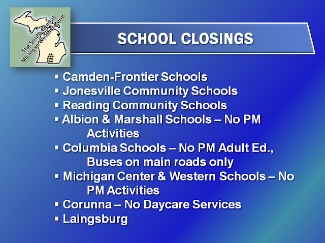
Stay tuned for additional closing information!

Stay tuned for additional closing information!
SCHOOL CLOSINGS FOR WEDNESDAY
Good Evening!
Some schools in the area have already called a snow day for tomorrow, here's the rundown so far:

We will add to and update this list as information becomes available.
Some schools in the area have already called a snow day for tomorrow, here's the rundown so far:

We will add to and update this list as information becomes available.
Storm Update #1
Good Afternoon!
We finally have the precipitation in the area that I said we would, just a bit tardy on the timing of it, but it's here. Have a look at the Grand Rapids NEXRAD radar image:

You can see all of the precipitation in the area right now, and it is a mixed bag. Depending on location, you can have observations of sleet, freezing rain, or just plain rain. There were even a couple of observations of snow on the board as well!
Taking a look at the forecast data as of now, the rain should continue for another hour, maybe two. Add at least a half-hour to changeover and times I mention in this post if you're in the north zone. See the temperature readouts on the side of the blog to determine where you're at. The thinking is that we should be in full changeover by 5 PM, with that process completed by 6-7 PM. Currently the setup is a layer of cold air between say 1000 to about 3000 feet off the ground is sandwiched by air that is warmer on either side. Rain falls, freezes, then melts again before it gets to the ground. No later than 5 PM, that warm air sandwich will be gone, and temperatures will be right at or below freezing, so watch out for the snow at that point. Let's summarize:

I have been busy fielding questions from people so have not had time to update the forecast. You'll have that soon! Remember - Winter Weather Advisory, all counties in the blog until 6 AM Wednesday morning.
More To Come...
Final Storm Prep...
Good Morning!
A bit less than 12 hours to go before the main event kicks off here in Michigan with our storm coming this way. We have cloudy skies in the area with temperatures between 28-34. Let's get into a deeper dive and see what's coming at us:
STORM ON THE WAY: Current Grand Rapids NEXRAD radar is showing precipitation in northern Indiana. They are seeing freezing rain and sleet currently, and this is what we will see as the storm works into this part of the world. We should start to see some freezing precipitation by lunchtime, and then the snow changeover occurs later on from south to north. No changes in the forecast thinking at this time, so we'll get on this horse and ride it going forward. Based on the data I have available to me now, we will see all modes of precipitation short of snow between now and say 2-5 PM. After 5 PM, the changeover should be well underway, and I would think that by 7-8 PM, we'll see big wet fluffy flakes falling from the heavens. To summarize:

TEMPERATURES: For most areas of the blog, we climb into the mid 30's today, then knock on the 40's door for tomorrow afternoon. That will help melt some of the snow we should pick up in the next 18-24 hours. The coldest temperatures look to show up for the weekend, with most areas hovering a couple of degrees either side of freezing Friday thru Sunday.
I will have the complete forecast around lunchtime for you.
WINTER WEATHER UPDATE
Good Morning!
Just a quick heads up that Livingston, Washtenaw and Lenawee counties have had their Winter Storm Watch changed to a Winter Weather Advisory.
Monday, February 25, 2013
WINTER WEATHER UPDATE
Good Evening!
If you haven't heard already by now, the Winter Storm Watch for part of the blog has been canceled. In it's place we have a Winter Weather Advisory. The National Weather Service (NWS) office in Grand Rapids has downgraded, but NWS Detroit is sticking by their Watch. Let's break it down by counties in the blog for you:
WINTER STORM WATCH
- Livingston
- Washtenaw
- Wayne
WINTER WEATHER ADVISORY
- Branch
- Hillsdale
- Calhoun
- Jackson
- Eaton
- Ingham
- Clinton
- Shiawassee
Have a look at this snowfall forecast map from the NWS. Right there you see the amounts, so it looks like my 3-5" and 6-8" predictions are in the ballpark, we finally have the clarity that was lacking earlier today...
 |
| National Weather Service Snowfall Forecast Thru Wednesday Morning |
This forecast map seems to be leaning toward the GFS solution, keeping the heavier snow in the south zone of the blog.
I will have a full update and forecast for you tomorrow. Have a great night!
Sun Before The Storm
Hello Again!
Sunshine greets us in the area this morning, something we have not seen for a few days. A refreshing change it is. Bright blue skies with just a few high clouds here in Jackson, and we will keep those around for awhile today and into the early evening, as clouds start rolling in ahead of our next storm system. Let's pop the hood and see what's running in there:
TEMPERATURES: We finally start to see some slight moderation in our cold pattern. Average temperature in the area should be right around 39 degrees, and we'll be right in that ballpark for all but one, maybe two of the next seven days. With the exception of some weekend chilly air, we'll stay in the 35-39 degree range. I am hopeful that some warming will start to make itself evident, as meteorological Spring is only four days away, and March 10th is the start of Daylight Savings Time. I can't wait!
TUESDAY STORM: The inevitable arguing amongst our computer model suites have begun. Two of the models that I look at, the Global Forecast System (GFS) and the North American Mesoscale Model (NAM) are showing me that we will get some snow, but the amount and duration varies. In most cases, this is typical. The GFS takes the low pressure center more southeast of us, more into Lenawee and Monroe counties, and the NAM is suggesting that we get a direct hit right through the heart of the blog. The low's track will make the difference in how much snow accumulates. At first blush, I am thinking 3-5" through Wednesday night, with another inch or so through Thursday. Some areas will see closer to 6-7" though, but firming that up will have to come this evening as fresh data comes out and we see what the atmosphere is doing in reality at that point of the day.
Now we have the two big things out of the way, so it's time for a forecast for Jackson and surrounding areas including Concord and Tompkins:
Today, mostly sunny through the afternoon, then clouds slowly re-develop, a bit milder with a high of 39. Wind NE 4-8 MPH.
Tonight, mostly cloudy skies after 11 PM, flurries possible, lows near 22, wind NE 6-12 MPH.
Tuesday, cloudy skies, a wintry mix is possible from mid-morning on, changing to snow by evening, 2-3" possible before midnight. Not as cold, high 37. Wind NE 7-14 MPH.
Tuesday night, cloudy, snow continues and slowly starts tapering off later, lows near 22. Winds NE 7-14 MPH.
Wednesday, continued daytime cloudiness, another 2-3" of new snow possible by nightfall, high 38.
Thursday, clouds stay around, some lingering snow may fall, another 1-2" possible depending on your area, high 37.
Friday, some breaks appear in the clouds, not as mild, high 30.
Saturday, clearing skies, colder, high 30.
There's a look at your forecast, we'll keep tabs on the storm situation and update here accordingly. Urgent updates will also be posted on Facebook and Twitter. Have a great day! Blessings.
DENSE FOG ADVISORY
Good Morning.
The National Weather Service has posted a Dense Fog Advisory for Clinton, Eaton, and Calhoun counties. Dense fog has formed overnight and will linger until the sun gets up high enough to burn it off.
Additionally, slick spots especially on bridges and overpasses may have formed with temps in the teens.
Use caution heading in to work and school this morning!
Sunday, February 24, 2013
Thoughts on Tuesday...
Good Evening...
I have been nosing around with BUFKIT and have had the chance to look over some forecast data. Still too soon to nail this down as far as an official forecast, but here's what I am seeing:
I have been nosing around with BUFKIT and have had the chance to look over some forecast data. Still too soon to nail this down as far as an official forecast, but here's what I am seeing:
- Tuesday morning a wintry mix is possible. Based on forecast model data, my money says that a window from 8 AM until about noon should fit the bill. Sleet, freezing rain or freezing drizzle. We would switch over to snow during the early afternoon, and a headache ensues for the Tuesday evening commute.
- Forecast modeling now suggests that we'll take a direct hit from the low coming out of the Plains, and the low will linger over the area for awhile.
- Snow stays in the area from Tuesday PM through Wednesday PM.
- Forecast snowfall is from 5 to 8.5" in the models I have looked at.
I am concerned about the thermodynamics of the whole situation. With data suggesting this will be a heavy wet snow event, it won't take much to tip the scales over to all rain and slash snowfall totals.
Have a great night!

Cloudy & Seasonable - Stormy Waters Ahead
Good Morning!
We had a bit of sunshine grace us with it's presence in the area yesterday, with temperatures hovering between 28 and freezing. Clouds returned and they are still there right now. Time for a deeper dive to see what's going on:
SUMMARY: Not a whole lot in process at the moment. Seasonably cold air in the base of a trough working through the area for the next day or so. Some northwest wind off Lake Michigan has cranked up the lake effect snow machine, so we will have to keep watch on that. The next big weather maker comes in here from almost due south on Tuesday, and early indications are that he is ready to wreak some havoc. Temperatures remain above freezing and climb well into the 30's by midweek...about the time that storm should be getting here. We stay in the 30's until the weekend, with just a few peeks at some sunshine here and there. On the topic of sunshine and warmer weather (hopefully), believe it or not, Daylight Savings Time is only a couple of weeks away so hang in there!
TUESDAY PM STORM: Tuesday night the low pressure center coming out of the Plains moves close enough to set the atmosphere off with the cold front he'll drag with him. This event will be a tricky one to nail down from a forecast perspective, as mixed mode precipitation is in the picture. Wintry mix systems are a pain to predict until you're right up against the arrival of the storm. I can tell you now that snow will definitely be a factor, so far this looks like a 3-6" of new snow affair, with more locally heavy snow possible. Some spots will also see a wintry mix of precipitation depending on how the air overhead is set up Tuesday evening. The evening drive home Tuesday night and the trip in to work or school Wednesday could be an adventure. Computer data is suggesting we kick off this event between 5 and 9 PM and carry it over into Wednesday afternoon.
A TOUCH OF PRE-STORM SNOW: Even with all the clouds in the area, I don't expect to see anything terribly organized until the above mentioned storm on Tuesday. However, some flurries or light snow is possible at times with northwesterly flow aloft and at the surface as you head west toward the lake shore. The lake-effect snow machine is running and some snow is evident on the Grand Rapids NEXRAD:
Don't be shocked to see some snow bands sneak this way and drop a little snow, or some flurries as the bands try to make it inland from the lake shore and fall apart on the way east.
The five day precipitation outlook from the National Weather Service shows that there will be plenty to go around, have a look at the map:
Cleveland has a 1.7 inch bullseye sitting over them, so that equates to several inches of snow coming off the lake for them. Here in our area, the forecast has backed off to about an inch of liquid, but that's still enough to create quite the mess of snow.
Here's a look at temperatures around the nation...

And this is for forecast for Jackson and surrounding areas:
Today, mainly cloudy, a peek at sunshine in spots, flurries or very light snow in spurts, high 33, winds WNW 5-10 MPH.
Tonight, continued mostly cloudy, perhaps a break for stars in some areas, flurries or light snow still linger, low of 20, winds slacken and turn NE 3-6 MPH.
Monday, some scattered sunshine in the morning, then the clouds come back, a bit warmer, high 36. Wind NE 4-8 MPH.
Monday night, cloudy skies, the chance of more flurries or a dusting of snow can't be eliminated, lows near 19, wind NE 6-12 MPH.
Tuesday, cloudy skies, snow starts Tuesday evening, 2-3" possible before midnight. Not as cold, high 37.
Wednesday, continued daytime cloudiness, another 2-3" of new snow possible by nightfall, high 38.
Thursday, clouds stay around, some lingering snow may fall, another 1-2" depending on your area, high 37.
Friday, some breaks appear in the clouds, not as mild, high 34.
Saturday, clearing and colder, high 28.
There's a look at your forecast for the next six days, I do hope that you have a wonderful day! Blessings.
We had a bit of sunshine grace us with it's presence in the area yesterday, with temperatures hovering between 28 and freezing. Clouds returned and they are still there right now. Time for a deeper dive to see what's going on:
SUMMARY: Not a whole lot in process at the moment. Seasonably cold air in the base of a trough working through the area for the next day or so. Some northwest wind off Lake Michigan has cranked up the lake effect snow machine, so we will have to keep watch on that. The next big weather maker comes in here from almost due south on Tuesday, and early indications are that he is ready to wreak some havoc. Temperatures remain above freezing and climb well into the 30's by midweek...about the time that storm should be getting here. We stay in the 30's until the weekend, with just a few peeks at some sunshine here and there. On the topic of sunshine and warmer weather (hopefully), believe it or not, Daylight Savings Time is only a couple of weeks away so hang in there!
TUESDAY PM STORM: Tuesday night the low pressure center coming out of the Plains moves close enough to set the atmosphere off with the cold front he'll drag with him. This event will be a tricky one to nail down from a forecast perspective, as mixed mode precipitation is in the picture. Wintry mix systems are a pain to predict until you're right up against the arrival of the storm. I can tell you now that snow will definitely be a factor, so far this looks like a 3-6" of new snow affair, with more locally heavy snow possible. Some spots will also see a wintry mix of precipitation depending on how the air overhead is set up Tuesday evening. The evening drive home Tuesday night and the trip in to work or school Wednesday could be an adventure. Computer data is suggesting we kick off this event between 5 and 9 PM and carry it over into Wednesday afternoon.
A TOUCH OF PRE-STORM SNOW: Even with all the clouds in the area, I don't expect to see anything terribly organized until the above mentioned storm on Tuesday. However, some flurries or light snow is possible at times with northwesterly flow aloft and at the surface as you head west toward the lake shore. The lake-effect snow machine is running and some snow is evident on the Grand Rapids NEXRAD:
 |
| Grand Rapids NEXRAD |
The five day precipitation outlook from the National Weather Service shows that there will be plenty to go around, have a look at the map:
 |
| National Weather Service 5 Day precipitation Forecast |
Here's a look at temperatures around the nation...

And this is for forecast for Jackson and surrounding areas:
Today, mainly cloudy, a peek at sunshine in spots, flurries or very light snow in spurts, high 33, winds WNW 5-10 MPH.
Tonight, continued mostly cloudy, perhaps a break for stars in some areas, flurries or light snow still linger, low of 20, winds slacken and turn NE 3-6 MPH.
Monday, some scattered sunshine in the morning, then the clouds come back, a bit warmer, high 36. Wind NE 4-8 MPH.
Monday night, cloudy skies, the chance of more flurries or a dusting of snow can't be eliminated, lows near 19, wind NE 6-12 MPH.
Tuesday, cloudy skies, snow starts Tuesday evening, 2-3" possible before midnight. Not as cold, high 37.
Wednesday, continued daytime cloudiness, another 2-3" of new snow possible by nightfall, high 38.
Thursday, clouds stay around, some lingering snow may fall, another 1-2" depending on your area, high 37.
Friday, some breaks appear in the clouds, not as mild, high 34.
Saturday, clearing and colder, high 28.
There's a look at your forecast for the next six days, I do hope that you have a wonderful day! Blessings.
Subscribe to:
Posts (Atom)