Hello!
Memorial Day Weekend 2012 is finally here! Whoopee!!! If you are having fireworks this weekend in your county and you are in the area covered by the South Central Michigan Weather Zone, let me know and I will get a forecast up for you. Right now the only counties that I am aware of that have fireworks this weekend in the area are Jackson and Ingham. Here's those two for tonight...
Jackson County: Your fireworks are at the beautiful Cascades in Jackson. I'm forecasting partly to mostly cloudy skies and temperatures around 75, winds ESE 7-12 MPH. No rain expected. It may be a bit muggy, with dewpoint values in the upper 50's.
Ingham County: You'll have another round of post-game fireworks at Cooley Law School Park, after the Lugnuts hopefully slay those Dayton Dragons! Conditions should be an almost carbon copy of Jackson's for tonight around dusk. Partly to mostly cloudy skies with temperatures around 76, winds ESE 7-12 MPH. Again, no rain, and possibly feeling a bit damp, with upper 50's dewpoints.
There you go. It looks like it should be a good night for fireworks watching. You may even be able to catch a glimpse at a star or two to boot! Enjoy, and BE SAFE!
Saturday, May 26, 2012
Air Quality Alert Issued For Sunday 5/27
An Air Quality Alert has been issued for Livingston, Lenawee and Washtenaw Counties for tomorrow, Sunday the 27th. Tomorrow has been designated an Ozone Action Day.
THE MICHIGAN DEPARTMENT OF ENVIRONMENTAL QUALITY HAS
DECLARED SUNDAY...MAY 27TH...TO BE AN ACTION DAY FOR
ELEVATED LEVELS OF OZONE. POLLUTANTS ARE EXPECTED TO BE IN THE
UNHEALTHY FOR SENSITIVE GROUPS RANGE.

THE ACTION DAY IS IN EFFECT FOR THE FOLLOWING MICHIGAN COUNTIES...

LENAWEE...LIVINGSTON...MACOMB...MONROE...OAKLAND...ST CLAIR...
WASHTENAW...AND WAYNE COUNTIES.

PEOPLE AND BUSINESSES ARE URGED TO AVOID ACTIVITIES WHICH LEAD
TO OZONE FORMATION. THESE ACTIVITIES INCLUDE...REFUELING VEHICLES
OR TOPPING OFF WHEN REFUELING...USING GASOLINE POWERED LAWN
EQUIPMENT...AND USING CHARCOAL LIGHTER FLUID. POSITIVE ACTIVITIES
INCLUDE...CAR POOLING...BIKING TO WORK...DELAYING OR COMBINING
ERRANDS AND USING WATER BASED PAINTS.

IT IS RECOMMENDED THAT ACTIVE CHILDREN AND ADULTS...AND PERSONS
WITH RESPIRATORY DISEASES SUCH AS ASTHMA...LIMIT PROLONGED
OUTDOOR EXERTION.

FOR FURTHER INFORMATION...PLEASE SEE THE MICHIGAN DEPARTMENT OF
NATURAL RESOURCES AND ENVIRONMENT AIR QUALITY INDEX PAGE ON THE
INTERNET AT...HTTP://WWW.DEQMIAIR.ORG
A Warm, Showery Holiday Weekend...
Good Morning!
BUSTED: I REALLY hate when my forecast gets busted. I own up to them every time though, to keep things honest. I am not yet a schooled meteorologist, and I don't just copy the National Weather Service forecasts, even though I look at a lot of the same data they have to create their forecasts. I do like to match wits with the trained meteorologists, and so far I have been doing fairly well keeping close to them. Not this trip. I predicted that we would see some scattered showers and possibly a thunderstorm, which verified, but I also said that they wouldn't show until this afternoon. BUST. Well, we have a radar full of scattered precipitation right now, and it's still morning. Let's take a look and see if we can sort this out with a deeper dive...
TEMPERATURES: Today we see warmer temperatures than Friday, and Sunday and Monday are very warm. The good news, we shouldn't be quite as hot as originally forecast. We'll still see 90, no doubt, but I don't think we edge quite as close to triple digits with the heat index values as first expected. In reality, it'll all probably feel about the same to you, and you'll still want a cold drink handy. A chance of showers and thunderstorms each day may put a kink in holiday outdoor plans. After that, upper 70's Tuesday, and a big cool down from hump day on, with daytime highs that don't make it out of the 60's making you reach for a jacket to toss in the car.
RAIN: We have some of that in the area now, and we'll keep it around here and there throughout the day. We could see some rain around fireworks time tonight of the scattered to numerous shower kind. My thinking is even with that, there should still be a window of a couple of dry hours to squeeze in a show, as both Lansing and Jackson are slated for displays tonight. We'll have to see what shakes out with the afternoon heating of the atmosphere.
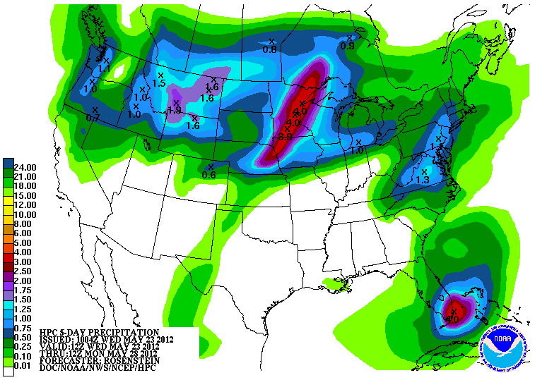
The National Weather Service has upgraded the amounts of rain in their 5 day forecast, and I think this looks about right for where we're headed, with the early development of rain today. Most areas throughout South Central Michigan are expected to pick up about anywhere from a half-inch to a little over an inch the next 5 days. Here's that map for you.

SEVERE WEATHER: It's been awhile since we've had to do this, but we'll take a look at maps from the Storm Prediction Center for all three days in the forecast window. Michigan has some sort of storm possibility each day of the next three. Here's a look at the maps from SPC, valid each day at 8AM as always:

This is today's forecast, with just the "general" risk for Michigan. The greatest risk today from storms that fire today would be heavy rain and hail:

Here's the map for tomorrow, again, just the "general" risk, low end 5% chances, heavy rain, wind and hail still the main threats.

Here's day three, Memorial Day, with the risk bumped up a notch to "slight". This percentages map shows us in 15% probability of severe weather. Bear in mind that you don't need to see percentages way up there for severe weather to occur. This would indicate hail, high wind, and a tornado threat.
Here's a look at things right now, the visible satellite image with the NEXRAD composite overlay on top, and a look at the Grand Rapids NEXRAD radar image for you as well.


And here's the forecast for Jackson County:
For today, mainly cloudy skies, maybe a few peeks of sun, periods of scattered to numerous showers and possibly an embedded thunderstorm, high 83, winds ESE 7-12 MPH.
Tonight, mainly cloudy skies continue, still the chance of scattered to numerous showers or a buried thunderstorm. Lows roll back to 60, SSE winds 5-10 MPH.
Sunday, periods of clouds and sun, very warm and humid, a chance of scattered showers and perhaps a thunderstorm, high 91. Heat index values will be well into the 90's with dew points in the mid 60's. Winds SSW 7-14 MPH.
Sunday night, skies clear a bit for a peek at stars, still the chance of a scattered shower or storm until about 1AM, low 68, winds SW 5-10 MPH.
Memorial Day, partly sunny early, then clouds increase with a chance of showers and thunderstorms in the afternoon, warm with highs approaching 91, heat index values will be well into the 90's again.
Tuesday, cloudy skies with showers and thunderstorms early, then clearing slowly, cooler, with a high of 78.
Wednesday, more sun than clouds, breezy and much cooler, high 71.
Thursday, a mix of clouds and sun, cooler still, high 66.
There's a look at your forecast for the next six days. I hope your Saturday is great. Expect a fireworks forecast later this afternoon for Jackson and Ingham counties here in Michigan. Blessings!
BUSTED: I REALLY hate when my forecast gets busted. I own up to them every time though, to keep things honest. I am not yet a schooled meteorologist, and I don't just copy the National Weather Service forecasts, even though I look at a lot of the same data they have to create their forecasts. I do like to match wits with the trained meteorologists, and so far I have been doing fairly well keeping close to them. Not this trip. I predicted that we would see some scattered showers and possibly a thunderstorm, which verified, but I also said that they wouldn't show until this afternoon. BUST. Well, we have a radar full of scattered precipitation right now, and it's still morning. Let's take a look and see if we can sort this out with a deeper dive...
TEMPERATURES: Today we see warmer temperatures than Friday, and Sunday and Monday are very warm. The good news, we shouldn't be quite as hot as originally forecast. We'll still see 90, no doubt, but I don't think we edge quite as close to triple digits with the heat index values as first expected. In reality, it'll all probably feel about the same to you, and you'll still want a cold drink handy. A chance of showers and thunderstorms each day may put a kink in holiday outdoor plans. After that, upper 70's Tuesday, and a big cool down from hump day on, with daytime highs that don't make it out of the 60's making you reach for a jacket to toss in the car.
RAIN: We have some of that in the area now, and we'll keep it around here and there throughout the day. We could see some rain around fireworks time tonight of the scattered to numerous shower kind. My thinking is even with that, there should still be a window of a couple of dry hours to squeeze in a show, as both Lansing and Jackson are slated for displays tonight. We'll have to see what shakes out with the afternoon heating of the atmosphere.
The National Weather Service has upgraded the amounts of rain in their 5 day forecast, and I think this looks about right for where we're headed, with the early development of rain today. Most areas throughout South Central Michigan are expected to pick up about anywhere from a half-inch to a little over an inch the next 5 days. Here's that map for you.

SEVERE WEATHER: It's been awhile since we've had to do this, but we'll take a look at maps from the Storm Prediction Center for all three days in the forecast window. Michigan has some sort of storm possibility each day of the next three. Here's a look at the maps from SPC, valid each day at 8AM as always:

This is today's forecast, with just the "general" risk for Michigan. The greatest risk today from storms that fire today would be heavy rain and hail:

Here's the map for tomorrow, again, just the "general" risk, low end 5% chances, heavy rain, wind and hail still the main threats.

Here's day three, Memorial Day, with the risk bumped up a notch to "slight". This percentages map shows us in 15% probability of severe weather. Bear in mind that you don't need to see percentages way up there for severe weather to occur. This would indicate hail, high wind, and a tornado threat.
Here's a look at things right now, the visible satellite image with the NEXRAD composite overlay on top, and a look at the Grand Rapids NEXRAD radar image for you as well.

Visible Satellite and NEXRAD Regional Composite Overlay

Grand Rapids NEXRAD Reflectivity
And here's the forecast for Jackson County:
For today, mainly cloudy skies, maybe a few peeks of sun, periods of scattered to numerous showers and possibly an embedded thunderstorm, high 83, winds ESE 7-12 MPH.
Tonight, mainly cloudy skies continue, still the chance of scattered to numerous showers or a buried thunderstorm. Lows roll back to 60, SSE winds 5-10 MPH.
Sunday, periods of clouds and sun, very warm and humid, a chance of scattered showers and perhaps a thunderstorm, high 91. Heat index values will be well into the 90's with dew points in the mid 60's. Winds SSW 7-14 MPH.
Sunday night, skies clear a bit for a peek at stars, still the chance of a scattered shower or storm until about 1AM, low 68, winds SW 5-10 MPH.
Memorial Day, partly sunny early, then clouds increase with a chance of showers and thunderstorms in the afternoon, warm with highs approaching 91, heat index values will be well into the 90's again.
Tuesday, cloudy skies with showers and thunderstorms early, then clearing slowly, cooler, with a high of 78.
Wednesday, more sun than clouds, breezy and much cooler, high 71.
Thursday, a mix of clouds and sun, cooler still, high 66.
There's a look at your forecast for the next six days. I hope your Saturday is great. Expect a fireworks forecast later this afternoon for Jackson and Ingham counties here in Michigan. Blessings!
Friday, May 25, 2012
Cool Friday, Some Weekend Sizzle...
Good Morning!


After a warm and breezy day yesterday, we'll be a touch cooler as a cold front moves though the area. Memorial Day weekend is shaping up to be a hot one, with temperatures around 90 or better, and heat indexes pushing triple digits. One deeper dive coming up!
TEMPERATURES: Today we stay seasonably mild, with temperatures in the low 80's and dewpoints that stay in the 50's, so it will feel a bit damp, but not too bad. After that, temperatures, humidity and dewpoints all start going up, making for a steamy holiday. Heat index values Memorial Day will be right around 100! After that, temperatures fall off dramatically with readings rolling back into the high 60's!?
RAIN: The National Weather Service is thinking that the rain for the next few days will track north of us here in South Central Michigan. We are forecast to pick up around a half inch of rain between now and 8AM Wednesday. Here's the map from the NWS:

Regarding timing, there will be a chance of showers and storms each day for the next few days, with the best chance at thunderstorms on Sunday. At this point we shouldn't see severe storms, but due to a juicy air mass with lots of moisture, it's a good bet that any storms that do fire could be strong.
SEVERE WEATHER: Yesterday in the forecast I mentioned that the Storm Prediction Center had already identified a severe storm risk for Memorial Day that involved this part of the world. I also told you that it was nothing to be overly concerned with yet, as that was still a ways out. At least for now, don't worry about it. That bullseye has disappeared and shifted further west. Just the regular "general" risk for storms for Michigan today and a 5% chance tomorrow. Here's those maps, valid at 8AM each day:


Any storms that form after today will be strong, as moister air works it's way in here from the south, pushing dew points well into the 60's.
Here's a look at the visible satellite image with just a few high clouds on it:

Grand Rapids NEXRAD radar is quiet at this hour.
Here's the local forecast for Jackson and surrounding communities including Spring Arbor and Pleasant Lake.
Today, periods of clouds and sunshine, high 81, winds become NW 8-15 MPH.
Tonight, a mix of clouds and stars, low 58, winds become NE 6-12 MPH.
Saturday, mostly cloudy skies with a few peeks of sunshine, perhaps the chance of a isolated shower or pop-up thunderstorm in the afternoon, warmer and more humid, high 84, winds
NE 5-10 MPH.
Saturday night, still mainly cloudy, humid, lows only down to 64 with ESE winds 5-10 MPH.
Sunday, mostly sunny with a few passing clouds, hot and humid, high 92, heat index values will approach 100.
Memorial Day, more clouds than sun, continued sticky with a chance of showers and thunderstorms, high 91.
Tuesday, cloudy skies and much cooler with a chance of scattered to numerous showers and thunderstorms, high only 76.
Wednesday, mostly sunny skies, cooler, high 68.
That's a look at your forecast for the next six, days, I do hope you have a good Friday! Blessings.
Thursday, May 24, 2012
Storm Prediction Center Updates Forecast Risk
Just a quick post to let you know that the Storm Prediction Center has updated their forecast for the Upper Midwest and boosted the severe threat to "Moderate". That does include just a smidge of the Upper Peninsula. Here's the map:

Currently, we do not expect that to move into this area, we'll keep an eye on it. Any further changes that directly impact South Central Michigan, we'll let you know. Have a great afternoon!
Currently, we do not expect that to move into this area, we'll keep an eye on it. Any further changes that directly impact South Central Michigan, we'll let you know. Have a great afternoon!
It's Getting Warm!
Good Morning!


First of all, a reminder that today is an Ozone Action Day in Livingston, Washtenaw, and Lenawee counties. People that are sensitive to Ozone and children should try to take it easy outdoors today. Check out the previous post for full details.
Now - yesterday was an IDEAL day outside, blue skies, low humidity, and just comfy all around. All of that starts to go bye-bye today, then Memorial Day weekend...man oh man. Let's take a deeper dive and see what's going on...
TEMPERATURES: Warm today, humidity values start to creep up as well, resulting in heat index values around 90. A bit of a break on Friday and into Saturday with moderating temperatures, then it heats up again Sunday, with heat index values climbing into the mid 90's thanks to increasing humidity, against upper 80's air temperatures with an occasional 90 as well! I need to go into a bit of detail about the upcoming heat here, I'll try to make this as quick and painless as possible...
Take a look at this map. It's a GFS (Global Forecast System) computer model map, one of many used to predict the weather:

This is the computer's idea of what the air about 18,000 feet up will look like at 11AM on Sunday May 27th. See that 588 the arrow is pointing to? If you look at the black line extending either side of that number and follow it, we are in the area bounded by that value. To a meteorologist (or student of weather such as myself), that 588 line means that there's a good chance surface temperatures will be near or above 90! The further south you go, the warmer it gets. If you look at the the black contour lines, that 588 is kind of a heat dome of sorts.
Memorial Day will definitely be a pool or beach day...if we can duck showers and thunderstorms. More on that below.
RAIN: A little bit wetter look than we have seen the last couple of model runs, with the National Weather Service now thinking that most places in Michigan will see about an inch of rain over the next five days. Here's a look at that map valid though 8AM Tuesday May 29th:

I still like the idea of us staying dry through Saturday, and then a chance at showers and thunderstorms Sunday through Tuesday. Cloudy conditions and dew points well into the 60's over the latter part of the weekend will make for humid conditions and plenty of moisture for storms to fire.
SEVERE WEATHER: Not much going on our way today, but out to the northwest of us in Wisconsin and the Upper Peninsula, the Storm Prediction Center has a "slight" risk bullseye in place. Based on the dynamics and conditions in place, I wouldn't be shocked to see SPC bump that up a notch to "moderate" in the same area for today. Here's a look at the Day 1 map, valid at 8AM today:

For tomorrow, Day 2, just a general risk of plain vanilla thunderstorms for much of Lower Michigan. In fact, the same can be said for many places in the US. Here's that map:

Now, nothing to be overly concerned with just yet, but I do want to mention this just to file away in your mind for future reference...Day 5, which is Memorial Day, a risk of severe weather is already defined. Here's where the bullseye is drawn:

That just clips the western part of the blog area. It's close enough that it bears watching. The area could shift, grow, shrink, or vanish altogether.
Here's a look at the visible satellite, Grand Rapids NEXRAD is quiet. All the action is northwest of us.

Now it's time for a look at the local forecast for Jackson County:
Today, clear skies with maybe just a few passing clouds, warm, high 85, southerly winds 8-15 MPH.
Tonight, mostly clear skies, a few clouds scattered about, low of 62, winds SW to W 8-15 MPH.
Friday, periods of clouds and sunshine, cooler, with a small chance of an isolated shower, high of 80. Winds NW 5-10 MPH.
Friday night, mainly cloudy skies with some breaks for stars, low of 54, winds NW winds swing and become NE 5-10 MPH.
Saturday, partly cloudy to start, then becoming overcast with a chance of scattered showers or a lonely thunderstorm, high 83.
Sunday, cloudy, humid, scattered to numerous showers and thunderstorms possible, high 87.
Memorial Day, cloudy, muggy, with a chance of scattered showers and thunderstorms, high 84.
Tuesday, cloudy, cooler, a chance of scattered showers and thunderstorms, high 77.
There's a look at your forecast for the next six days, I do hope your Thursday is great! Blessings.
Wednesday, May 23, 2012
Air Quality Alert: Livingston, Lenawee, Washtenaw
Good Evening.
The National Weather Service has forwarded an Air Quality Alert from the Michigan Dept. of Environmental Quality regarding tomorrow being an Ozone Action Day. Here's the text of the advisory:
The National Weather Service has forwarded an Air Quality Alert from the Michigan Dept. of Environmental Quality regarding tomorrow being an Ozone Action Day. Here's the text of the advisory:
...AIR QUALITY ALERT FOR THURSDAY MAY 24TH...

THE MICHIGAN DEPARTMENT OF ENVIRONMENTAL QUALITY HAS
DECLARED THURSDAY...MAY 24TH...TO BE AN ACTION DAY FOR
ELEVATED LEVELS OF OZONE. POLLUTANTS ARE EXPECTED TO BE IN THE
UNHEALTHY FOR SENSITIVE GROUPS RANGE.

THE ACTION DAY IS IN EFFECT FOR THE FOLLOWING MICHIGAN COUNTIES...

LENAWEE...LIVINGSTON...MACOMB...MONROE...OAKLAND...ST CLAIR...
WASHTENAW...AND WAYNE COUNTIES.

PEOPLE AND BUSINESSES ARE URGED TO AVOID ACTIVITIES WHICH LEAD
TO OZONE FORMATION. THESE ACTIVITIES INCLUDE...REFUELING VEHICLES
OR TOPPING OFF WHEN REFUELING...USING GASOLINE POWERED LAWN
EQUIPMENT...AND USING CHARCOAL LIGHTER FLUID. POSITIVE ACTIVITIES
INCLUDE...CAR POOLING...BIKING TO WORK...DELAYING OR COMBINING
ERRANDS AND USING WATER BASED PAINTS.

IT IS RECOMMENDED THAT ACTIVE CHILDREN AND ADULTS...AND PERSONS
WITH RESPIRATORY DISEASES SUCH AS ASTHMA...LIMIT PROLONGED
OUTDOOR EXERTION.

FOR FURTHER INFORMATION...PLEASE SEE THE MICHIGAN DEPARTMENT OF
NATURAL RESOURCES AND ENVIRONMENT AIR QUALITY INDEX PAGE ON THE
INTERNET AT...HTTP://WWW.DEQMIAIR.ORG
Warmer, more humid conditions are expected with limited chances of rain over the next few days. Be mindful. Full forecast tomorrow.
Sun, Warmth, SUMMER!
Good Morning!
Sunny skies have returned to the area after the clouds broke late yesterday. The warm-up is on the way as we breeze right through the 70's today and push 90 a couple of times the next few days. We'll also have a shot at some rain over the next few days as well. Let's take a deeper dive and see what we have going on out there...
TEMPERATURES: We see temperatures right at or just above seasonal levels today, then things warm up to the upper 80's on Thursday, with a brief moderation in temperature. The weekend looks very warm, with temperatures in the upper 80's again. I would not be surprised to see a 90 or two as we kick off summer with the arrival of Memorial Day. As a whole we run well above average, which is around 75 in this neck of the woods for this time of year. Tuesday we'll see a cool down, as temperatures are expected to roll back into the lower 70's.
RAIN: Things are looking a bit wetter now than they have in past days, with the National Weather Service suggesting that the southern half of lower Michigan will pick up about an inch of rain the next five days. The best chances of rain look to be in the weekend, with a chance of showers and storms each day starting on Saturday and going all the way through Tuesday. My take on things is that we'll stay dry on Saturday, and we pick up some rain on Sunday into Monday. Here's a look at the National Weather Service map for total rainfall between now and 8AM Monday...

SEVERE WEATHER: You'll have to go way up and over to the far western Upper Peninsula for that. Tomorrow the Storm Prediction Center is showing a "slight" risk for severe storms in the western part of the U.P. Here's that map for you, valid at 8AM tomorrow.

NO thunderstorms of any kind expected here for the next three days.
Bright blue skies in Jackson this morning, Grand Rapids NEXRAD radar is quiet as Sunday Mass, here's the visible satellite image, showing not a whole lot going on in Michigan right now.

Here's the local forecast for Jackson and surrounding communities including Spring Arbor and Brooklyn:
For today, sunny, pleasant, high 77, winds SSE 5-10 MPH.
Tonight, clear skies with maybe a passing cloud or two, low 57, winds SSE 3-8 MPH.
Thursday, continued clear, warmer, high 85, winds southerly 8-15 MPH.
Thursday night, mostly clear skies, a few clouds pass by, low of 63, winds SSW 8-15 MPH.
Friday, a mix of clouds and sunshine with a small chance of an isolated shower, high of 80.
Saturday, partly sunny to start then clouds increase during the day with a chance of scattered showers or a lonely thunderstorm, high 80.
Sunday, cloudy, a chance of scattered to numerous showers and thunderstorms, high 85.
Memorial Day, cloudy with a chance of scattered showers and thunderstorms, high 85.
There's your local forecast for the next 6 days, I do hope you have a great Wednesday! Blessings!
Sunny skies have returned to the area after the clouds broke late yesterday. The warm-up is on the way as we breeze right through the 70's today and push 90 a couple of times the next few days. We'll also have a shot at some rain over the next few days as well. Let's take a deeper dive and see what we have going on out there...
TEMPERATURES: We see temperatures right at or just above seasonal levels today, then things warm up to the upper 80's on Thursday, with a brief moderation in temperature. The weekend looks very warm, with temperatures in the upper 80's again. I would not be surprised to see a 90 or two as we kick off summer with the arrival of Memorial Day. As a whole we run well above average, which is around 75 in this neck of the woods for this time of year. Tuesday we'll see a cool down, as temperatures are expected to roll back into the lower 70's.
RAIN: Things are looking a bit wetter now than they have in past days, with the National Weather Service suggesting that the southern half of lower Michigan will pick up about an inch of rain the next five days. The best chances of rain look to be in the weekend, with a chance of showers and storms each day starting on Saturday and going all the way through Tuesday. My take on things is that we'll stay dry on Saturday, and we pick up some rain on Sunday into Monday. Here's a look at the National Weather Service map for total rainfall between now and 8AM Monday...
SEVERE WEATHER: You'll have to go way up and over to the far western Upper Peninsula for that. Tomorrow the Storm Prediction Center is showing a "slight" risk for severe storms in the western part of the U.P. Here's that map for you, valid at 8AM tomorrow.

NO thunderstorms of any kind expected here for the next three days.
Bright blue skies in Jackson this morning, Grand Rapids NEXRAD radar is quiet as Sunday Mass, here's the visible satellite image, showing not a whole lot going on in Michigan right now.

Here's the local forecast for Jackson and surrounding communities including Spring Arbor and Brooklyn:
For today, sunny, pleasant, high 77, winds SSE 5-10 MPH.
Tonight, clear skies with maybe a passing cloud or two, low 57, winds SSE 3-8 MPH.
Thursday, continued clear, warmer, high 85, winds southerly 8-15 MPH.
Thursday night, mostly clear skies, a few clouds pass by, low of 63, winds SSW 8-15 MPH.
Friday, a mix of clouds and sunshine with a small chance of an isolated shower, high of 80.
Saturday, partly sunny to start then clouds increase during the day with a chance of scattered showers or a lonely thunderstorm, high 80.
Sunday, cloudy, a chance of scattered to numerous showers and thunderstorms, high 85.
Memorial Day, cloudy with a chance of scattered showers and thunderstorms, high 85.
There's your local forecast for the next 6 days, I do hope you have a great Wednesday! Blessings!
Tuesday, May 22, 2012
Cool, Gray, Quiet...
Good Morning!
A cool, damp day yesterday as the cold front came though and started things sprinkling on us as it moved by. Gray and quiet today. Let's take a deeper dive and see if things get any better...
TEMPERATURES: A 10-15 degree swing on the back side of the cold front that tracked through yesterday evening and shifted winds to the northwest brought in cooler temperatures for much of lower Michigan, not just here in the blog area. Temperatures plunged way down into the 40's last night throughout this part of the world, and most places are just into the 50's as I write this.
We do see changes coming later this week though, as warm air returns. Computer models like 80's starting on Thursday, and continuing until next Tuesday. Sunday is forecast to be the warmest day of the week, with the GFS suggesting a high of 88 for Jackson! Be patient, warmth returns shortly, I promise you.
RAIN: Not a whole lot of wet stuff on tap. The National Weather Service is thinking that Michigan only picks up a half-inch of rain tops the next five days. In fact, most places only pick up around a quarter inch between now and 8AM Sunday morning. Here's the map showing that...

Not much moving through here once that ridge elbows it's way back into town with the warm air and sits on us like the one from this past weekend.
SEVERE WEATHER: Nothing to write about regarding rough weather for Lower Michigan the next three days. All the risk and forecasting involves Wisconsin and the Upper Peninsula exclusively. Today and tomorrow, a "general" risk of storms for the western part of the U.P. And for Thursday, a "slight" risk for severe storms covering the western half of the U.P. again. Here's the SPC Day 3 forecast map:

Grand Rapids NEXRAD radar is snoring, here's the visible satellite image showing the cloudiness over us now, but that should start to dissipate as the day progresses...

And here's the local forecast for Jackson and surrounding communities including Parma and Michigan Center:
For today, cloudy early, skies start to clear late, cool, high 71, winds N 5-10 MPH.
Tonight, mainly clear skies with perhaps a few scattered clouds low 45, winds NE 3-8 MPH.
Wednesday, sunny skies and pleasant, warmer with a high of 77, winds SSE 5-10 MPH.
Wednesday night, starry skies and cool, low of 45. Winds S 3-8 MPH.
Thursday, sunny, warmer still high 85.
Friday, clouds increase during the day, not quite as warm, chance of a scattered shower late, high 82.
Saturday, mostly cloudy, a chance at a scattered shower or lonely thunderstorm, high 85.
Sunday, periods of clouds and sunshine, very warm, high 88, heat indexes could reach into the mid 90's.
That's a look at your forecast for the next six days, I do hope you have a great Tuesday! Blessings.
Monday, May 21, 2012
Light Showers, Cooler Temperatures...
Good Morning!
What a FANTASTIC weekend was it not? Warm and rain-free, any outdoor activity was possible, and sunscreen, bug repellent and a cold drink were the finishing touches. I sure hope you had a chance to get out and enjoy some of it. The warm summer-like weekend is behind us now, and as we head back to work today, cooler temperatures settle in with us through Wednesday, then the warmth comes back, with the thermometers again eyeballing 90. One deeper dive coming up...
TEMPERATURES: In the blog area, three records fell, two more were tied yesterday as temperatures throughout South Central Michigan were well into the 80's. Out in west Michigan, a couple of 90 degree readings were posted. We'll be 10-15 degrees cooler today across most parts of the blog, as a shortwave trough tracks across the area, pulling down a bit of cooler air from Canada along with it. We stay in the 70's until ridging with warm air under it pushes back in, sending readings back into the mid to upper 80's for Thursday, then a slight moderation in temperature puts us in the 76-83 range for the rest of the week.
RAIN: Pretty quiet overall, with just a a few showers showing on radar. Not a ton of heating around to provide enough instability for anything significant right now, even though we have decently moist air, with dew points in the mid to upper 50's or better. Here's a look at the Grand Rapids NEXRAD radar image...

This is what the National Weather Service says about rain for the next five days. Heavier rainfall expected in the Pacific Northwest, the US/Canada border above Minnesota, and offshore of Florida. Here in southern Lower Michigan, no more than a quarter-inch is expected between now and 8AM EDT on Friday...

The next quality chance for rain in this part of the world looks to be late Friday night into early Saturday, and this far in advance, modeling is suggesting a scattered shower with a possible roaming storm affair, as opposed to anything more organized.
SEVERE WEATHER: Once we get past the "general" thunderstorm risk today, nothing for the three day window according to the Storm Prediction Center. The only reason we even have the general risk today is mainly for thunderstorms forming out in front of this slow moving cold front this afternoon and into tonight. Here's a look at the Day 1 map, valid today at 8AM EDT:

Here's a look at the visible satellite image, with the NEXRAD radar composite overlaid on it...just a line of light showers on the move...

Here's the local forecast for Jackson and surrounding communities including Rives Junction and Summit Township:
For today, mostly cloudy skies with a peek of sun here or there, just the chance of an isolated or widely scattered shower, cooler with a high of 73, winds swing from SSW to NW 8-14 MPH.
Tonight, a mixture of clouds and stars, cooler, low 47, northerly winds rolling back to 5-8 MPH.
Tuesday, periods of clouds and sunshine, pleasant, high 73, winds N 5-10 MPH.
Tuesday night, mostly starry skies with a passing cloud or two, low 49, winds NE 3-8 MPH.
Wednesday, sunny, seasonable, nice, high 79.
Thursday, sunny, warmer as southwesterly winds return, high 86.
Friday, increasing clouds, not quite as warm, high 83.
Saturday, mostly cloudy, a chance of scattered showers, high 78.
There's a look at your forecast for the next six days, I do hope you have a great Monday! Blessings.
Sunday, May 20, 2012
Warm It Up!!!!
Good Evening!
Just a quick post to fill you in on the record warmth in the South Central Michigan Weather Zone today, and to let you know that any thunderstorms we may get late tonight and into tomorrow should NOT be severe, but just the plain vanilla ones as forecast this morning. Highs were up there!
Lansing - 88
Jackson - 89
Battle Creek - 89 (RECORD, Previous 82, 1998)
Howell - 87 (RECORD, Previous 82, 1998)
Mason - 88
St. John's - 88
Corunna (Owosso) - 88
Charlotte - 87
Ann Arbor - 86 (RECORD, Previous 80, 2004)
Adrian - 89
Hillsdale - 88 (Tie, 88 in 1977)
Coldwater - 88 (Tie, 88 in 1977)
Have a great evening, we'll see you tomorrow!
Sunny Sunday Spectacular!!!
Good Morning!
A fantastic day in South Central Michigan yesterday, and we've got another winner lined up today. More abundant sunshine and temperatures a couple of degrees warmer than yesterday. Let's take a deeper dive and see what's going on...
TEMPERATURES: We'll see temperatures make a run at 90 today in some spots, with most areas settling into the high 80's. Plenty of sunshine on tap and gentle breezes. It will be the perfect late spring/early summer day. Temperatures will remain warm until a front moves through tonight into tomorrow. After that, we see temperatures roll back into the mid to upper 70's.
RAIN: Three computer models like rain in the area at different times and with different intensities. I'm still saying that we get through today and into tonight dry, then rain slowly filters in during the late evening and pre-dawn hours. Monday will be wet, no question, but it doesn't look like a total washout. There will be a couple of brief rain-free periods mixed in during the day as well. The National Weather Service says we should pick up about a half-inch of rain during the next five days. Here's that map.

That looks about right, and after we get through tomorrow and perhaps early Tuesday, cooler, drier conditions prevail.
SEVERE WEATHER: Nothing forecast for Michigan's Lower Peninsula the next three days beyond the regular "general" risk for plain thunderstorms. Today does bear watching, as there is a "slight" risk bullseye that covers the central part of the Upper Peninsula, eastern Wisconsin and north central Illinois. Some of those storms could wander over here to the Lower Peninsula and rain on us...or more...Here's the maps from the Storm Prediction Center for days one and two, valid at 8AM each day as always.


And here's a look at the visible satellite image with a bit of a twist, as it has the NEXRAD radar composite overlaid on it, so you can see where there rain and storms are already firing...

And here's the local forecast for Jackson County:
For today, sunny, breezy, very warm, high 87, some areas covered by the blog should hit 90. SSW winds 8-15 MPH.
Tonight, mild, clouds on the increase late with a chance of scattered showers and storms, low 59, winds SW 5-10 MPH.
Monday, mainly cloudy, cooler, periods of scattered to numerous showers, high of 72, winds NW 7-12 MPH.
Monday night, clearing skies, much cooler than Sunday night, lows roll back to near 47 with NW winds 5-10 MPH.
Tuesday, a mix of clouds and sunshine, a chance of a widely scattered shower early, high 74.
Wednesday, sunny, mild, nice, high 76.
Thursday, mostly sunny skies, a few passing clouds in the afternoon, warmer, high 84.
Friday, mostly cloudy skies, a chance of a scattered shower or lonely thunderstorm, high 80.
There's a look at your forecast for the next six days. I do hope you have a wonderful Sunday! Blessings.
Subscribe to:
Comments (Atom)