Saturday, April 6, 2013

Mild & Damp On The Way

Good Afternoon!

Sun is in the skies, some mid to high level cloudiness in the area as well.  Some showers out over Lake Michigan that will track east-northeast and miss us - at least for now.  Let's take a deeper dive and see what's under the hood...

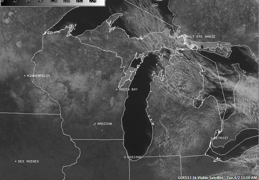
WARMING UP SLOWLY:  Temperatures right now are in the 40's with SSE winds.  We'll see those readings climb as the day progresses when the winds finish spinning around to the SW.  Readings well into the 50's and pushing 60 in some cases are back in Illinois, Chicago, Kankakee and Moline, among other places.  A dry slot in front of an upper wave ahead of the main surface low is keeping things clear and rain-free here, it's also holding down the temperatures.  Have a look at this composite map:

Visible Satellite Image with NEXRAD Composite and Surface Observation  overlays
NOT RAIN FREE TONIGHT:  Some scattered shower activity is out over the lake and moving northeast. Right now the air is pretty dry, so I think that we miss out on this for the most part, some stray showers could develop later this afternoon, but we really don't get into the higher rain probabilities until later this evening as southwest flow establishes and the warmer, moister air filters in.  Some scattered showers this evening, becoming more a touch more numerous with time.  Along with that, an embedded thunderstorm can't be ruled out.

WARMER, NOT SUMMER-LIKE THOUGH:  We'll see temperatures trending up as we go into next week, but not the 70 that was advertised yesterday.  Daytime highs will top out around 64 by next Wednesday.  After that, sharply cooler for the rest of the week.  I told you I wasn't buying that 70!

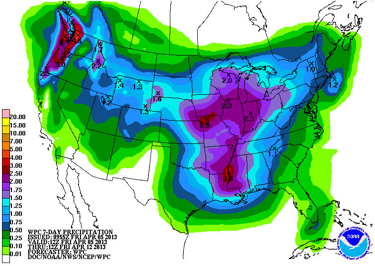
RAIN TONIGHT AND MONDAY:  The two chances at rain are tonight and Monday night.  A surface low passes northwest of us tonight, bringing snow to the Upper Peninsula.  Fortunately we stay on the warm side of this.  Dry tomorrow, then some rain again to start the new week.  Here's a look at the WPC Precipitation Forecast:

WPC 7 Day Precipitation Forecast
This has gotten a bit wetter, with a three inch rain bullseye in the area.

Here's a look at the radar, showing those showers off to the northwest.

Grand Rapids NEXRAD Composite Radar
Here's the forecast for Jackson and surrounding areas:


This afternoon, mostly cloudy by afternoon.  A stray afternoon shower in some spots is possible, high 56.  Winds turn SW increasing to 10-20 MPH.

Tonight, cloudy, a few scattered showers, even a roaming thunderstorm cannot be ruled out, milder, lows only roll back to 45. Wind SW 10-20 MPH.

Sunday, clearing by lunchtime leaves fair skies, mixed sunshine, seasonably warm, high 55, wind becoming ESE 5-10 MPH.

Sunday night, a mix of clouds and stars, colder than Saturday night, lows down to 35.  Wind NW 5-10 MPH turn ESE toward daybreak.

Monday, partly sunny skies, a pop-up rain shower is possible, high 60.

Tuesday, cloudy skies, scattered showers and a couple of  thunderstorms likely, mild, high 60.

Wednesday, continued mainly cloudy, some lingering showers and perhaps a buried storm are possible, warmer still, high 62.

Thursday, a mix of clouds and sunshine, still the chance of some scattered showers, cooler, high 50.

Friday, mainly cloudy, a few peeks of sunshine, some hit or miss showers are possible, high 56.

Saturday, some clouds and sunshine mix, high 55.

There's your forecast for the next seven days, have a great weekend!

Friday, April 5, 2013

Spring Finally Sprung From Hiding!

Good Afternoon!

This is more like it!  Milder days and cool or even chilly nights.  That's what Spring in Michigan is all about.  We'll see buds on the trees and flowers soon if they haven't already started waking up.  There's only one component missing right now - rain.  We'll have that soon enough.  Let's take a look and see what's running under the hood!

FINALLY SOME MILD WEATHER:  Yes indeed, and it gets better - after a brief backslide today into the mid or upper 40's from near 60 degree readings around the area on Thursday.  The GFS forecast model is suggesting we see a 70 or two in the area next Tuesday!  I am still skeptical of that at this point, but anything in the 50's or better...we'll take that.  My money says mid 60's for Tuesday.  After that, we drop back into more seasonable conditions, with temperatures making it comfortably into the 50's through the tail end of next week.  Average high temperature in Jackson this time of year is about 55 degrees, we shouldn't fall below that, in fact I think we stay above it until Wednesday, then we stick pretty close to that mark.

APRIL SHOWERS YET?:  You bet.  The next few days will have some shots of rain, and perhaps the first rumbles of thunder this season may be heard this weekend as well.  Warmer air with some moisture migrates in for the day tomorrow, sending high temperatures close to the 60 degree mark.  My take: we stay dry for much of the day Saturday, working some post-lunch clouds in, then add some scattered evening showers, and perhaps a lone thunderstorm.  We'll dry out around lunchtime on Sunday if not sooner, and stay that way until Monday evening, when our next chance of showers and perhaps some thunder presents itself.  Let's look at the WPC 7 Day Precipitation Forecast:

Weather Prediction Center 7 Day Total Precipitation Thru 8 AM Friday 4/12/13
There's some of those April showers you need to get the crops and flowers off to a good start.  A pretty damp look for South Central Michigan, with an inch and a half or better of rain expected statewide.

SEVERE WEATHER:  Now that the upper-air flow has reset into a more seasonable pattern, moist, tasty Gulf air for storms to chow on can filter well inland, interacting with cooler air and smaller waves and disturbances, kicking off showers and thunderstorms.  Nothing severe in this part of the world to worry with for the next week, but the Storm Prediction Center is eyeing a potentially significant severe weather event for Kansas, the central and southern Plains, and the lower Mississippi valley into Dixie Alley.  Have a look at the SPC forecast map:

Storm Prediction Center Severe Weather Outlook Days 4-8
I show you this in case you're headed that way next week.  There's not a chance of nailing down timing, severity, or location this early in the game, just file it away as a "re-check in a day or so" item.  We will know a lot more at that point in time.

CLOSER TO HOME:  The visible satellite showing plenty of SUNSHINE!  Readings holding in the mid to upper 40's at the reporting stations...

Visible Satellite Image with station observation plots overlaid - the stick with lines (a wind barb) shows wind speed in knots, and it points in the direction wind is blowing FROM.  Red numbers are surface temperature, green numbers are dew point values.  Letters are the station identifier: JXN - Jackson, LAN - Lansing, BTL - Battle Creek, ARB - Ann Arbor.
And with that bright blue sky, no point showing you the Grand Rapids NEXRAD - unless you like looking at ground clutter around the radar.

Here's the forecast for Jackson and surrounding areas including Parma and Grass Lake:

This afternoon, sunny, breezy, seasonably cool, high 50, wind NNW 6-12 MPH.

Tonight, clear skies, cold, lows near 25, wind NW 5-10 MPH.

Tomorrow, clear early morning skies become mostly cloudy by afternoon.  Stray afternoon showers become more numerous later, high 56.  Winds turn SW increasing to 8-16 MPH.

Tomorrow night, cloudy, a 50/50 chance of scattered showers, a lonely thunderstorm cannot be ruled out, milder, lows only roll back to 42. Wind SW 10-20 MPH.

Sunday, any lingering showers should be gone by lunchtime, leaving fair skies, mixed sunshine, seasonably warm, high 56, wind becoming ESE 5-10 MPH.

Monday, partly sunny skies, a pop-up rain shower is possible, high 60.

Tuesday, cloudy skies, scattered to numerous showers and a few thunderstorms likely, unseasonably mild, high 67.

Wednesday, continued mainly cloudy, some lingering showers are possible, not as warm, high 60.

Thursday, a mix of clouds and sunshine, still the chance of some scattered showers, cooler, high 54.

Friday, mainly cloudy, a few peeks of sunshine, some hit or miss showers are possible, high 56.

There's your forecast for the next seven days, I do hope that you have a wonderful Friday - and a great weekend.  Blessings.  Wish me luck as I get settled into the new place!

On The Move...

Hello!

I have been quiet the last few days, but not without cause.  I have relocated.  Not far, just 20 miles west, but still enough has been going on that my attention has been pulled away from the blog.  Excuse me while I help the family get settled into the new digs.

The blog is here and I hope to make it better as year two gets rolling.  Stay Tuned!

Tuesday, April 2, 2013

Warming Is Waiting In The Wings...

Good Morning!

Another day of mixed sunshine and chilly conditions is upon us here in South Central Michigan.  We'll keep them around for another day or so, but a nice warm up is on the way, along with some April Showers.  Let's pop the hood and see what we having running in there!

I THOUGHT SPRING WAS HERE!?:  Don't worry, it's coming back, I promise you.  We just need to allow the upper air patterns to reset, and that starts happening in the next 24-36 hours.  Right now, the lower 48 is under a ridge west/trough east setup.  If you're under the trough, the door is open for cool air from Canada.  Northwest breezes stay with us until late tomorrow into Thursday.  Have a look at this surface temperature plot and you can see what I mean:


The cold air is heavy and stable, so the milder, lighter air from the Pacific and points southwest can't go through, it gets shunted around and south.  A brief shot of warmer air comes in Thursday, sending us into the 50's again.  Another upper wave rotates in behind that, knocking us back into the 40's.  That gets out of here for Saturday, allowing ridging to reload into the area, and we get the 50's back.  This time I think those stay around here for awhile.  The usual 15-20 degree swing that I have observed during the warm season applies, so nighttime lows will be anywhere from 22 to 34 over the next several days.  Add 15 to 20 degrees to that during the day and you're pretty close to the high.

TURN THE SHOWERS ON:  You need some April showers for May flowers according to the old saying, so we start working on those this weekend.  The upper wave that pushes us from 40's to 50's between Friday and Saturday will also touch off some scattered shower activity as it works through the front slope of the larger ridge.  Nothing to worry about, just have an umbrella with you and you'll be fine.  Keep it handy into Sunday as well.  Have a look at the 7 Day WPC Precipitation Forecast Map...


Showers should be pretty well out of here late Sunday afternoon, with temperatures in the 50's.  Another crack at rain comes Monday afternoon, as an additional little disturbance scoots by, bothering the atmosphere enough to create a few more widely scattered showers.  If you're north of I-94 you may not even see anything Monday, this disturbance is expected to slide through Northern Indiana and Ohio if the forecast models have a handle on it.

Forecast modeling is showing more rain Wednesday and Thursday, so we'll pin that on the "re-check list" and see what shakes out in the future.  Anything more than 7 days out is suspect anyhow.

SEVERE WEATHER:  Too cold here yet to worry about that, and the Storm Prediction Center severe storm risk areas are about where you'd expect them to be this time of year, the south end of Tornado Alley (OK/TX), rotating through Dixie Alley and the Deep South for days two and three.

Looking at the visible satellite, just some broken stratocumulus clouds about, you can see the upper air winds  kind of curving a bit in the northern part of Michigan.  The white stuff in Wisconsin is surface snow cover that hasn't melted off yet.  Nothing to see on the Grand Rapids NEXRAD right now.

Visible Satellite Image
Here's the forecast for Jackson and surrounding areas including Concord and Rives Junction:


Today, mixed sunshine, a touch warmer but still chilly, high 41, wind NW 7-14 MPH.

Tonight, mainly clear skies, cold night, low near 20, wind fairly steady at NW 6-12 MPH.

Wednesday, mostly sunny, finally starting to warm a bit, high 45.  Winds turn SW 5-10 MPH.

Wednesday night, still clear, maybe a few stray clouds, not as cold, lows near 25, wind SW 5-10 MPH.

Thursday, sunny and pleasant, seasonable temperatures return, high 56.

Friday, mostly sunny, a few passing clouds, not as warm as Thursday, high 50.

Saturday, clouds develop around lunchtime, bringing scattered afternoon showers, high 56.

Sunday, cloudy skies, a lingering shower can't be ruled out, high 53.

Monday, mixed sunshine and cooler, still seasonable, high 51.

There's a look at your forecast for the next six days, I do hope that you have a great day!  Blessings.

Monday, April 1, 2013

Chilly Start, Spring Returns Late Week....

Good Morning!

Partly sunny skies greet us in South Central Michigan this morning, along with some chilly conditions.  A couple of spots even pocked up some flurries during the overnight hours.  Spring has temporarily paused, but not to worry!  It will be back.  Right now, a deeper dive is in order to see what we have going on here:

CHILLY WEATHER FOR AWHILE:  It stays here for a few days, but it's not as bad as what we have endured during the winter.  There will be some chilly nights, no doubt about it, but we also see daytime temperatures making it into mid 40's territory without a huge effort.  Chilly Canadian air has filtered in, and we are under a moderate amplitude ridge/trough/ridge upper air setup.  That's a fancy way of saying mild Pacific air is being diverted well south before it can turn back north again, and cold air is sagging into the US, pushing near freezing temperatures all the way into Tennessee.  Have a look at the current surface temperature map to see what I'm talking about:


Thursday, we see a shift in the pattern and the upper air flow flattens out some, winds come in more westerly, as opposed to diving in from Canada.  This allows temperatures to moderate some, and the ridging puts it in gear and starts moving our way.  We see upper 40's and the whole range of 50's back in the area as the end sum of that change.

WARMING NICELY FOR THE WEEKEND:  The headline says it all, but I will tell you that right now, the GFS forecast model likes a high of 56 on Thursday (I think that's a little ambitious right now), and we could make a run at 60 on Sunday!  As always, use caution with these statements, 7 days out is a bit early to hang your hat on anything.  I'll keep an eye on it and see how the modeling evolves.

A DRY LOOK 'TIL SATURDAY:  There's just not much of anything in the picture until the weekend.  An occasional lake effect flurry possible in this cold air, owing to the northwest wind off Lake Michigan, but aside from that, not a lot until a weak upper disturbance passes through Friday and maybe gets close enough to us that we think about a shower or two.  The more credible threat for scattered showers and perhaps a buried storm appears to be Saturday afternoon and evening.  If you're headed home from Spring Break, keep the umbrella handy.  Take a look at this map from the Weather Prediction Center, they do introduce some moisture into the game, but my money says what you see forecast on the map is a weekend deal:

National Weather Service Weather Prediction Center 7 Day Precipitation Forecast
A half inch total throughout pretty much the entire state between now and 8 AM next Monday morning.  Again - a lot can happen in seven days, this WILL change.

SEVERE WEATHER:  You'd have no clue that we are in severe weather season. Thanks to the upper atmosphere dynamics, we have been largely blocked out of all the rough stuff.  Any system with the moxie to start a ruckus has been shunted south of us or fallen apart in the face of a big fat stable cold air mass before it made it here.  And the systems that did hold together were starved of a crucial severe weather ingredient, usually unstable moist air to nosh on.  The severe weather is where you'd expect it this time of year, "slight" risk areas today and tomorrow in the south end of Tornado Alley, TX/OK.

Closer to home, the visible satellite shows that northwest flow off the lake, and you can almost see the cyclonic flow in the cloud bands up northeast into Canada:

Visible Satellite Image
Looking at Grand Rapids NEXRAD, this should look familiar - the right clouds you need for some lake effect snow bands.  Bear in mind that this is shooting aloft, so the returns here are likely not hitting the ground...

Grand Rapids NEXRAD Radar
And here's the forecast for Jackson and vicinity:

Today, a mix of clouds and sunshine, the clouds may have a few flurries in them.  Chilly, high 36, winds NW 10-20 MPH.

Tonight, a mix of clouds and stars, cold, lows near 20, wind NW 6-13 MPH.

Tuesday, sunny, a touch milder, high 40, wind NW 7-14 MPH.

Tuesday night, mostly starry skies, another cold night, low near 21, wind NW 6-12 MPH.

Wednesday, mostly sunny, warmer still, high 45.

Thursday, continued clear, seasonable temperatures return, high 54.

Friday, mostly sunny, a few passing clouds, a slight chance of an isolated shower or two Friday afternoon with increasing clouds, high 53.

Saturday, cloudy, scattered afternoon showers and perhaps the mention of a lonely thunderstorm, high 56.

Sunday, cloudy skies, a lingering shower or two possible, high 57.

There's a look at your forecast for the next six days, i do hope that you have a wonderful Monday!  Blessings.

Time Flies When You're Having Fun!!!

Do you realize that it has been ONE YEAR since I decided to take the plunge and blog about something I enjoy?  This has been an amazing ride so far!  I have met and made many friends, if only over the Web, and I have learned so much about the weather and meteorology as well.  I have been humbled by busted forecasts, celebrated forecasts that I have nailed, and have seen Nature at her best and worst.

If you're a reader, thanks for putting up with me for the last year, I hope I have made it bearable, if not enjoyable.  I also hope that I have provided some useful information at some point in time, as I have decided that I will be making one last career change into meteorology, and I plan to ride this horse until my sun sets.

If you're one of the meteorologists or forecasters that I have reached out to with questions, THANK YOU FOR TAKING TIME TO ANSWER ME!  I could not have gotten to this point without your help, support, and willingness to help me expand my knowledge base.

There's too many people for me to thank by name, because I don't want to short change anyone.  So suffice it to say that I appreciate all of you.  I look forward to growing this blog and my expertise, and hope to really  get into it when I get rolling with my classes and become a credentialed forecaster and eventually a Meteorologist.

Thanks!  Let's keep it going!

Mike

Sunday, March 31, 2013

A Brief Break From Spring...

Good Evening!

Our cool down is in full efect right now with winds turning more westerly on their way to northwest as a trough drops in from Canada, bringing us some chilly air for the next few days.  Let's take a look and see what we have on tap:

COOL IT OFF, REWARM IT:  Jackson reached 57 degrees today, with 56 in Battle Creek and 55 in Lansing.  That mild air is all but out of here as we have reading in the low to mid 40's across the board in the blog, and we will get down intot he 20's before daybreak Monday.  We'll keep readings in the 40's through midweek, then we start to pick up some warmth and get back into the seasonable 50's, carrying them into the weekend.  Average temperature this time of year is right around 53 degrees, and once we make it to Thursday, we get back into the ballpark and stay there right through the forecast window.

DRY WEEK ON TAP:  A pretty dry look in store for this part of the world, even though we are in the base of a trough, there isn't much in the way of disturbances embedded within it to create any real fuss.  There is the slight chance of a couple of snowflakes tomorrow, but other than that, we come under the influence of a couple of high pressure systems, keeping us dry and fair, with a few clouds here and there.  The next big chance for rain comes on Saturday where we have a chance at some scattered shower activity. Have a look at thye 5 day precipitation forecast from the National Weather Service:


As it stands right now, BONE DRY in this part of the world over the next five days.

Here's alook at the forecast for Jackson and surrounding areas including Parma and Michigan Center:

Tonight, cloudy and cold, lows roll back to near 27, wind NW 6-12 MPH.

Monday, mainly cloudy, perhaps some PM sunshine, high only 41.  Wind NW 6-12 MPH.

Monday night, mainly clear and very cold, lows all the the way down to 19, wind NW 3-6 MPH.

We will have an extended look at the forecast for you tomorrow.  Also, a special day - more on that to come!