Saturday, April 21, 2012

Cool But Dry For Awhile...

Good Morning.

The rain has moved off to the east, and some of the clouds along with it.  Now we're sitting under a very chilly air mass, imported from Canada.  What you see now is what you'll get for pretty much the entire week, with a slight warming trend thrown in.

On the east coast, all the models agree that Philadelphia, Baltimore, and points northeast will be treated to some snow courtesy of a late season Nor'Easter that starts off the coast of Georgia and South Carolina, then hugs the eastern seaboard before backing up inland over Maryland, New Jersey and New York State.  Let's take a deeper dive:

TEMPERATURES:  The warmest we'll see for the next few days is mid 50's, perhaps an outside chance at a 60 and a brief break in this pattern on Wednesday into Thursday, then back to the cool stuff until next Saturday, if the GFS model run is correct.

RAIN:  For Michigan, we see a little bit of an upper disturbance come though Tuesday as the trough over the eastern US really digs in deep, with that intense surface low off to the east in upstate New York and likely causing all kinds of snow madness there, we may see a shower or a snowflake as a result, but it shouldn't be much, or long duration, if we get anything at all.  This will change, as one model says a pretty strong low will scoot just south of us Wednesday evening into Thursday, kicking off some rain.  It's too early yet to see if we'll be dealing with two separate systems, or if the models are looking at the same thing and arguing about the arrival time, but for my money, I think it's the same system, and the models can't line up a time just yet.  Here's what the National Weather Service thinks we'll be getting in the way of precipitation the next five days:


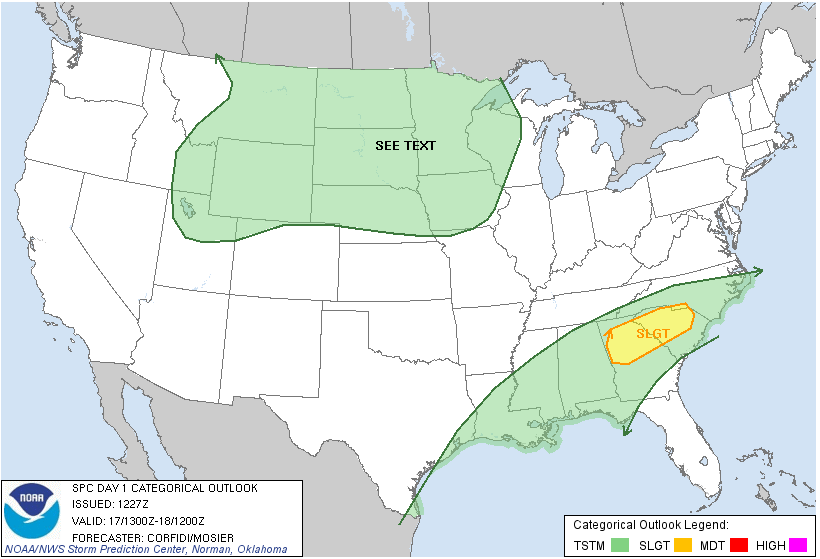
SEVERE WEATHER:  Not unless you want to count a severe headache from being sick with the temperatures fluctuating wildly week to week.  The only "slight" risk category on the map is the south half of the Florida peninsula for today.  Here's a look at that on  the map:


After that, no risk of anything beyond everyday thunderstorms for the next few days anywhere in the country.  This is a good thing, considering the tornadoes last week in the Plains, and the one-year anniversary of the 2011 Super Outbreak in the Deep South on April 27th.

Here's the local forecast for Jackson County:  today clouds should be mostly gone by early afternoon, then partly sunny, cool, high temperatures near 55, winds NE 5-10 MPH.

Tonight: Periods of clouds and stars, chilly, lows roll all the way back to 33, don't be surprised to see a frost or freeze warning posted tonight, winds calm to NNE at 8 MPH.

Sunday, mostly cloudy, perhaps a few peeks at sunshine here and there, high temperature 55, winds increasing to northerly 10-20 MPH.

Sunday Night: clearing, cold, lows will hover within a degree of freezing, winds north 5-10 MPH.

Monday: Clear skies, cool, high of 55, winds north but turning easterly, 5-10 MPH.

Tuesday: Sunny to start, then increasing clouds with a chance of a shower, a bit warmer, high of 57

Wednesday: Cloudy, chance of rain, high near 60.

Thursday: Periods of clouds and sun, warmer, high of 62.

There's a look at your forecast for today, I do hope you have a wonderful Saturday!  Blessings.

Friday, April 20, 2012

FREEZE WARNING ISSUED

The National Weather Service has issued a Freeze Warning for Clinton County...


...FREEZE WARNING IN EFFECT FROM MIDNIGHT TONIGHT TO 9 AM EDT
SATURDAY...

THE NATIONAL WEATHER SERVICE IN GRAND RAPIDS HAS ISSUED A FREEZE
WARNING...WHICH IS IN EFFECT FROM MIDNIGHT TONIGHT TO 9 AM EDT
SATURDAY.

HAZARDOUS WEATHER...

* FREEZING TEMPERATURES MAINLY NORTH OF INTERSTATE 96 BY 7 AM.

* ONE TO TWO HOURS OF TEMPERATURES JUST BELOW FREEZING IN SPOTS.

IMPACTS...

* DAMAGE TO UNPROTECTED VEGETATION IS POSSIBLE.

PRECAUTIONARY/PREPAREDNESS ACTIONS...

* A FREEZE WARNING IS ISSUED WHEN FREEZING TEMPERATURES ARE FORECAST
TO THREATEN OUTDOOR PLANTS. THOSE WITH AGRICULTURAL INTERESTS
IN THE WARNED AREA ARE ADVISED TO HARVEST OR PROTECT TENDER
VEGETATION. ALSO... POTTED PLANTS NORMALLY LEFT OUTDOORS SHOULD
BE COVERED OR BROUGHT INSIDE AWAY FROM THE COLD.

Cold Here...Winter's Back in the Northeast?

Good afternoon!


Just a bit of tweaking to the forecast and an update as well.  That colder Canadian air is more intense than I thought looking at the maps and model data this morning.  So I have to unfortunately put the "S" word into the forecast again.  That's right, we may see a bit of snow mixed in with the raindrops tonight.  That air will be cold when it does get here.  Forget about the 540 line (a "rule of thumb" line on a forecast map - north of it is generally below freezing, opposite if you're south), I see us north of the 534 line...that will make for a chilly start to tomorrow for sure.


Here's one for you: out on the east coast, how about some mayhem with a late season Nor'easter?  Sunday into Monday, the offshore low I discussed in the morning forecast will manage to snag some of the moisture from the departing surface low that is putting us into the cooler air now, as well as bring it's own supply of moisture with it.  Running headlong into that cold Canadian air mass could set up a pretty significant late season snow event from Pennsylvania into New York and up through New England.  We'll have to see how that plays out over the next 48 hours.


Tonight's forecast is modified as follows:  Cloudy, chance of showers or some light snow, lows near 33, north winds 10-20 MPH.  No accumulation is expected from any snow that falls.


That's all for now, have a wonderful afternoon!  Blessings.

Now Comes the Wet Stuff...

Good Morning!


Let's get the painful stuff out of the way first.  I have to own up to a busted forecast of sorts.  I had more confidence that it would already be wet in South Central Michigan, and that hasn't happened yet.  I also predicted nighttime lows for Jackson of 52, and from what I can see, we didn't dip below 55.  It did not cool as I expected it to, we had some cloud cover to keep the daytime and evening heat blanketed in.  The low didn't get here as I figured it would, keeping us dry.  I guess a no rain and warmer than forecast bust is one I can live with, if I have to take one at all.


TEMPERATURES:  Enjoy this mild air while you can, it's on the way out of here tonight into tomorrow as low pressure arrives from the southwest, tracking up through southeastern Michigan.  We'll see temperatures swing 20 to 30 degrees over the next day or so.  On the backside of the cold front, evening low temperatures will once again flirt with the freezing mark, a far cry from the 60's and occasional 70 we have had in the area.  That colder air isn't going anywhere either.  


A trough digs in over Michigan and the eastern Great Lakes, importing more colder Canadian air, keeping temperatures in the 50's well into next week.  Another strong low pressure system will start offshore near Georgia and South Carolina on Sunday and meander north, hugging the east coast, then actually "back up" northwest and move inland, over New Jersey and New York.  We'll be in the backside flow from that low as well, keeping colder air coming in over Michigan. The US will be split nearly in two, with a big ridge of warm air building into the west and the Plains, while most places east of the Mississippi and north of Georgia, South Carolina, and Tennessee will be chilly until that ridge pushes that Canadian import out mid week!  Here's two maps to help you see what's going on.  Look for the low (letter "L") down by Georgia and South Carolina on 8AM Sunday according to the GFS model...


Now look at where it is on Monday at 8AM...
It's up over Pennsylvania and Delaware, and the counter-clockwise airflow off the back brings cooler air down from Canada, keeping us cool in Michigan!


RAIN:  The surface low that was already forecast to be here let off the gas some yesterday.  Current model runs all agree that we'll be seeing some rain after lunch today, and it will carry through into tomorrow morning.  That low looks to track right up into Detroit, and we'll pick up most of our rain on the cooler back side of it.  As a result, I don't see a huge chance for thunder, but we'll leave a shot at an embedded thunderstorm in the forecast.  That low is expected to be gone in a little more than half a day once it does start raining, but it'll drop a lot of precipitation during it's stay.  The National Weather Service has upped the ante a bit to over 2 inches of rain in the bullseye northwest of us.  The South zone of the blog should see up to a half inch, the North zone counties will see closer to a inch or a touch more out of this rain-maker.  Here's a look at the predicted totals for the next 5 days:


Notice all the rain from that crazy low out on the eastern seaboard!


SEVERE WEATHER:  Today is the only day the Storm Prediction Center is currently forecasting any risk, and that's just a garden variety storm risk.  The best chance at rough stuff is along the Texas Gulf Coast then inland a ways today, and then tomorrow the Florida Peninsula gets a chance at severe storms.  Here's the Day 1 forecast, valid at 8AM today:


Southeastern Michigan is where storms may fire in advance of the front and low pressure system.


OK! A lot to go over, here's the forecast For Jackson and surrounding communities including Michigan Center and Rives Junction.


For today, a few peeks of sun early, then cloudy skies as showers and perhaps a hidden thunderstorm move in, high temperature 66, winds SW turning NW, 10-20 MPH.


Tonight, showers, possibly a lonely thunderstorm mixed in, lows drop to 34 with northerly winds 7-15 MPH.


Saturday, cloudy early then clearing by after lunchtime, much cooler, high of 55, NNE winds 7-15 MPH.


Saturday night, main starry, perhaps a couple of passing clouds, lows, near 34, winds NE 5-10 MPH.


Sunday, sunny, cool, high near 54, winds NE 5-10 MPH.


Back to work Monday with sunny skies, a touch warmer, highs near 56, winds ESE 5-10 MPH.


Tuesday, more sun than clouds, high of 56.


Wednesday, mostly clear, but a few clouds in the afternoon, high of 59.


Thursday, cloudy skies with a chance of showers, high of 62.


That's your forecast for the next 7 days, I hope you have a great Friday and weekend!  Blessings.

Thursday, April 19, 2012

Not Quite So Wet?

Good Morning!


As we roll downhill into the weekend, it looks to be a damp one, but not so wet as in prior forecasts.  It looks like there will be a space or two during the weekend to squeeze in some outdoor activities, where with earlier forecasts, the whole weekend looked to be pretty well washed out.


Warmer air has settled into the area, with most spots reporting 50's already, with some clouds in the area.  We're close enough to the weekend now that we can get a fairly clear picture of how things should shake out, so one deeper dive coming up!


TEMPERATURES:  We'll see most places in South Central Michigan make a good run at or get to 70 or better today, all under increasingly cloudy skies, with perhaps a touch of sun here and there.  We'll be keeping the clouds around for the weekend, as a low pressure system tracks this way from the southwest.  After today, we'll see temperatures start trending down again, landing in the mid 50's during the day to start next week.


RAIN:  It's coming, that's for sure.  Indications are that we should be able to get though most of the day dry, with a dry trip home for the evening commute.  We'll start the rain around dinnertime.  That will stay with us off and on all weekend long.  The shower activity we get will give us some decent watering though, rain totals for the next 5 days should come in from a quarter-inch southeast to an inch or so northwest.  Here's a look at the 5 day precipitation map from the National Weather Service.


This will help out the grass and the flower beds in the area.  Off to the northwest though, where that surface low is expected to track, look at that almost 2 inches of rain up through Cadillac, Manistee, and up to Traverse City.  And out east, over three inches is expected between now and Monday morning!


SEVERE WEATHER:  Go far away for that.  The Storm Prediction Center is currently forecasting only one day out of the next three where any part of lower Michigan has any chance at thunderstorm activity, and that's for tomorrow.  Here's the map for that day only which is Day 2, the forecast is valid starting at 8AM Friday morning:


As you can see, just a risk of plain ol' thunderstorms, off in the extreme southeast corner of Michigan.


Here's the current satellite image.  I had to use a different source than I usually do, as the regular site is down for maintenance.  You can see the map of Michigan with the satellite data superimposed on it.  Not much going on.


Now with that done, here's the local forecast for Jackson and surrounding communities including Vandercook Lake and Hanover:


For today, sunny to start, then increasing clouds, high temperature 72, winds SW 5-10 MPH.


Tonight, cloudy skies, a 40% chance of showers late, nighttime lows of 52, winds southerly 8-15 MPH.


Friday, cloudy, rain showers start after lunchtime, a bit cooler with a high of 63.  Winds NNW 5-10 MPH.


Friday night, cloudy skies clear off late, nighttime lows down to 35, winds N 10-15 MPH.


Saturday, sunny, cooler, high temperatures near 55, winds NNE 7-15 MPH.


Sunday, periods of clouds and sunshine, seasonable, high 55.


Back to work on Monday under clear skies, high of 56.


Tuesday, clear skies, warming, high of 60.


There's a look at your forecast for the next 6 days - I do hope you have a wonderful Thursday!  Blessings.

Wednesday, April 18, 2012

Sunny Skies, Wet Weekend Shaping Up...

Good Morning!

It's a clear start to a gorgeous day here in Jackson and South Central Michigan.  Enjoy it, because this will likely be the last really nice day for the rest of the week, as a system approaches us from out west, bringing with it rain showers and somewhat cooler temperatures.  There's not really a whole lot going on around the US today.  Let's take a deeper dive:

TEMPERATURES:  We'll make it well into the 60's today under mostly clear skies, though some clouds should start rolling in as the evening commute gets under way.  Some places do have a crack at 70, especially in the south zone.  An upper level wave moves through, bringing along with it some showers and perhaps an embedded thundershower or storm.  Temperatures will roll back to around 50, then rebound nicely.  Most spots in the area should see a 70 for tomorrow.  The weekend is looking a little warmer than in past forecasts - the models are printing lows in the mid to upper 40's, and the lowest daytime high is around 61.

RAIN:  Each day tomorrow afternoon through Sunday, we'll have a shot at some scattered showers with perhaps a roaming thunderstorm.  This forecast is a little wetter than prior runs, owing to a couple of upper-level disturbances moving through, and then an actual upper trough that comes through on Friday evening into Saturday pre-dawn.  Here's the National Weather Service rain forecast for the next 5 days.


Most of south central Michigan looks to be about an inch of rain, but just off to the northwest of us, those areas will see upwards of two inches between now and early next week.  The 2-inch rainfall areas are where that trough is expected to travel through.  The upper disturbances are just that - they'll bother the atmosphere enough to make it rain some, but that's about all.  Here's a look at the visible satellite image, take a good look over Wisconsin, that's where that upper disturbance is right now that will cloud up things and get us wet as early as tonight...


SEVERE WEATHER:  Nothing.  Most of the Upper Peninsula and the western half of the L.P. are under the low 5% risk for garden-variety thunderstorms today.  Tomorrow, it's just the counties in the South zone, and it looks like Washtenaw and maybe even Jackson County will miss even the low end threat.  Not even a "slight" risk category on the map anywhere - rare for this time of year.  Here's a look at the Storm Prediction Center's forecast for today and tomorrow.  The maps are, as always, valid at 8AM.


Now that the groundwork is laid, time for the forecast for Jackson and surrounding communities including Napoleon and Concord.

For today, mostly sunny skies, with a few passing clouds, high temperature near 64, winds SSW increasing to 10-20 MPH by nightfall.

Tonight, mostly starry skies with some clouds, nighttime lows near 50, winds SW 7-15 MPH.

Thursday, sunny skies to start, then clouds slowly increase ahead of that upper disturbance arriving, chance of showers after lunch, high of 69, SW winds 7-15 MPH.

Tomorrow night, showers likely, perhaps a roaming thunderstorm, lows near 48, winds SW 10-15 MPH.

Friday, cloudy skies, showers likely and perhaps a lonely thunderstorm embedded in the showers, high of 60, winds southerly 5-10 MPH.

Saturday, cloudy skies, showers and a couple of thunderstorms likely, high near 58.

Sunday, a lingering shower possible early, then clearing, seasonable, high near 61.

Monday, periods of clouds and sunshine, a outside chance of a shower, hear near 57.

Tuesday, partly sunny, warming slightly, high of 61.

There's your forecast for this hump day Wednesday, I do hope you have a wonderful day!  Blessings.


Tuesday, April 17, 2012

FROST ADVISORY POSTED

All counties in the South Central Michigan Weather Zone: Frost Advisory until 8 AM Wednesday morning. Go to www.weather.gov for details.

You Bring Me Sunshine...

Good Afternoon!


Man, yesterday literally blew out of here with winds howling all day long!  Winds around the area were consistently in the 20-35 MPH range, with gusts up to 61 MPH!  That's Tropical Storm territory!  I was out in it yesterday afternoon umpiring high school baseball.  Fortunately I was behind the plate, so my protective gear and jacket kept me nice and toasty :-).  Those people watching their kids play were hardy souls indeed, they were all bundled up with blankets and such, like it was a late October football game!  I hope you were warm, at least on the inside!


Now that the upper wave and surface low have moved away and taken blowhard along with it, on the more stable backside of it all, we just have bright blue skies and a few passing clouds in south central Michigan at this hour.  Here's a look at the satellite image.


Just a few wispy, high clouds across the north half of Michigan.


It's quite a bit cooler today than yesterday, but it probably feels nicer, because you don't have that strong northwest or north wind cutting through you today.  Most area wind reports are in the 5-10 MPH range.  Let's take a look at what else is in store for the South Central Michigan Weather Zone...one deeper dive coming up!


TEMPERATURES:  Much cooler today than yesterday, even though it won't feel as cool due to the greatly reduced wind.  We'll see temperatures in the mid 50's, some areas, especially the south zone, will try to stretch to 60, but I don't see that happening.  We'll have a clear night tonight, and some patchy frost is not out of the question, then some milder temperatures tomorrow, as winds swing back around more southerly, with a bit of warm air advection - that's a $5 word for warmer air pushing in and telling the colder air to take a hike.  That milder air hangs around for a bit, then the mercury dips again in time for the weekend, as cooler Canadian air starts reclaiming some space over Michigan.


RAIN:  Nothing until tomorrow evening, as an upper level wave and the surface low running with it pass us off to the northwest, through upper Wisconsin, just clipping the U.P.  The models say it'll trigger some showers down here at this end of Michigan tomorrow night into Thursday.  That surface low is not very strong, so we'll see what we get on the next model run.  The GFS and the NAM (two of our fearless computer models) are also showing a series of upper level waves coming in behind the Wednesday night/Thursday shower-maker.  Because of the waves, once we get the clouds in here Wednesday night into Thursday, we'll keep them and a chance of showers in the forecast through the weekend.  Here's what the National Weather Service is thinking regarding rain over the next 5 days...

The estimate is between half and three-quarters of an inch in this part of the world.

SEVERE WEATHER:  Nope.  The only severe we'll be seeing today and into tomorrow is severe clear!  Bright sunny skies throughout the entire area.  There is a "general" risk of thunderstorms across the northern half of the center third of the US, and a "slight" risk of severe weather through Georgia and South Carolina and that's about it for today.  Day 2, just a "general" risk of severe storms through the northwestern part of Michigan and a sliver of the upper peninsula, that's it!  Here are the Day 1 and Day 2 maps from the Storm Prediction Center, valid at 8AM each day.  


Here's the radar image from Grand Rapids with current observations overlaid on it.  Remember that circle around the radar site is "ground clutter", buildings and such that show up as radar returns but don't really count.


Now that the foundation is laid, it's time for the local forecast for Jackson and surrounding communities including Parma and Brooklyn.


For today, sunny skies, gentle breezes, a few passing clouds, high near 58 with WNW winds 5-10 MPH.


Tonight, mostly starry skies, some patchy frost is possible, lows near 35, any winds will be NNE calm to 5 MPH.


Wednesday, clear skies, some passing clouds, pleasant, high near 67, winds swing around from the south 10-20 MPH.


Wednesday night, clouds increase, a slight chance of showers late, nighttime low of 51, SW winds roll back to 7-15 MPH.


Thursday, mostly cloudy, perhaps a break or two in the clouds allowing for a peek of sun, periods of rain showers, high temperatures near 67, winds SW 5-10 MPH.


Friday, a near-replay of Thursday but cooler, cloudy, a few breaks in the clouds, chance of showers, high near 55.


Saturday, still cloudy, still a chance of rainshowers, still a high near 55.


Sunday, clouds early, then they FINALLY start to break later in the day, warming to a high of 58.


That's a look at your forecast for this Tuesday, I do hope your day is great!  Blessings. 

Monday, April 16, 2012

Hold Your Hats, Grab Your Jackets!

Good Morning!


Windy and springlike in Jackson...for now.  Temperatures will take a nosedive today as a strong surface low escapes the US and tracks into Canada.  It's centered over northwestern Wisconsin.  In fact, under that surface low, it is SNOWING there at this hour.  I don't expect us to see any of that, though it surely will be cold enough to snow by late tonight and into tomorrow.  


Elsewhere around the US, the Plains continue to pick up the pieces from the weekend's severe weather event through Tornado Alley.  Regrettably, there is now a 6th fatality from the Woodward, OK tornado.  This is why you need a weather radio or something indoors to warn you that a tornado may be coming through your town.  Though I talk somewhat tongue-in-cheek about tornadoes "visiting", etc., it really is NOT a laughing matter.  Several professionals, including meteorologists and emergency management specialists have weighed in, saying that had those people gotten timely warning AND had a plan, they might be alive today.


Let's take a deeper dive into the area weather picture:


TEMPERATURES:  We'll start the day in the 60's, then watch the mercury slowly fall as a fairly muscular surface low tracks up through Wisconsin and the Upper Peninsula, before escaping north of the border.  We actually get twin barreled action from that.  We had an upper level wave push through early this morning, kicking off some showers and embedded thundershowers.  That's gone, with STRONG south winds behind it.  The surface low movement turns the winds westerly and starts the cool down.  Another upper-level wave comes through, possibly triggering a few more showers, and then a cold Canadian high settles in behind that.  We'll struggle into the mid 50's tomorrow, but then temperatures rebound a bit as we get a bit of warmer southerly flow back.


RAIN:  The models seem to like the next chance for rain to come on Wednesday evening, as another upper disturbance tracks through the northern part of the Lower Peninsula, but close enough that it could trigger a shower or two.  After that, we'll keep a chance of rain in the picture into the weekend.  Here's the 5-day rain totals as predicted by the National Weather Service.  We'll come in around an inch, give or take, during the next 5 days.


SEVERE WEATHER:  Not here.  Here's what the Storm Prediction Center is saying, remember these maps are valid at 8AM each day:


Thankfully, things look to have settled down.  The "slight" risk is well off to the east of us, and just a "general" risk in the eastern part of Michigan.  After that we should be in the clear. No storms forecast anywhere on the third day.


Here's a look at the satellite image, and radar from Grand Rapids.


Not much, that circle is ground clutter around the radar in Grand Rapids.  Just a few light showers over Detroit and Windsor, Ontario, leaving the area.


It's time for the local forecast for Jackson and vicinity.


For today: High Wind Advisory in effect until 10PM.  Periods of clouds and sunshine with a chance of a scattered shower or two, perhaps an embedded thundershower hiding as well.  High temperatures near 66 but falling, winds SW 25-35 MPH but gusting to 45 MPH or better at times, also turning northwesterly toward evening.


Tonight: still a slight chance of scattered showers early, then cold, nighttime lows near 36, winds slow to NW 20-30 MPH, then taper off further to 10-15 MPH after midnight.


Tuesday morning: we could see some scattered frost, mainly clear and much cooler, high near 55.  NW winds 7-15 MPH.


Tomorrow night: mostly starry skies, chilly, frost possible, nighttime lows roll back to 34, NW winds 5-10 MPH, tapering off as the night progresses.


Wednesday: Sunny, warming nicely after a chilly start, temperatures near 70, winds S 5-10 MPH.


Thursday:  A mix of clouds and sunshine, with a chance of scattered showers, high near 63.


Friday: Mainly cloudy, cooler, a 40% chance of rain, high 55.


Saturday:  Mostly sunny skies, maybe a passing cloud or two, cooler, daytime high struggles to get to 52.


That's a look at your weather for this Monday.  Have a great day!  Blessings.

WIND ADVISORY ISSUED...

Good Morning!


The National Weather Service has issued a Wind Advisory for today through 10PM for the entire area...


...WIND ADVISORY REMAINS IN EFFECT UNTIL 10 PM EDT THIS EVENING... 
HAZARDOUS WEATHER... 

* SOUTHERLY WINDS WILL INCREASE THIS MORNING TO BETWEEN 25 TO 35
MPH. WIND GUSTS TO 50 MPH CAN BE EXPECTED.

* WINDS WILL CONTINUE THROUGH THE DAY TODAY...AND WILL
GRADUALLY BECOME WESTERLY BY LATE AFTERNOON.

* WINDS WILL DIMINISH THIS EVENING.
IMPACTS...

* DOWNED LIMBS AND BRANCHES CAN BE EXPECTED THROUGH EARLY THIS
EVENING. SOME POWER OUTAGES WILL BE POSSIBLE ACROSS THE AREA.

* DRIVING HIGH PROFILE VEHICLES WILL BE DIFFICULT.

* LOOSE OBJECTS SUCH AS TRASH CANS WILL BE BLOWN AROUND.
* A WIND ADVISORY MEANS THAT SUSTAINED WINDS OF 30 TO 39 MPH OR GUSTS BETWEEN 45 AND 57 MPH CAN BE EXPECTED. WINDS THIS STRONG CAN MAKE DRIVING DIFFICULT...ESPECIALLY FOR HIGH PROFILE VEHICLES. USE EXTRA CAUTION.


Take it easy out there.  Forecast on the way!

Sunday, April 15, 2012

SIGNIFICANT WEATHER STATEMENT Livingston Co., NWS reports pea size hail, winds 40 mph or better, downpours. Storm in NE Livingston Co. moving E @ 40 MPH.

Rain, Rewind, Repeat...

Good Morning!

For the first time in many hours, there are no Tornado watches active in the US.  Regrettably, five people have been killed in Woodward, OK from a tornado that hit there shortly after 1AM EDT.  People were saying they had no warning and didn't hear the sirens.  Let me rant here briefly...If your only source of information for a Tornado Warning impacting your community is an outdoor siren, you're risking your life.  PERIOD.  You need a weather radio or a smartphone app.  Thanks, enough ranting.  

Everyone's eyes are turned toward the Plains to see what the damage was from the over 100 tornadoes reported yesterday.  However we still have South Central Michigan to tend to, so we'll do just that.

Showers and thunderstorms moved through the area early this morning.  We'll have a break, and then those are expected to re-fire later.  At this point we don't expect anything severe.  Elevated, possibly.  By elevated we're talking heavy downpours, gusty winds and intense lightning.  Could there be hail?  Possibly small hail.  We'll have to keep an eye on that, with temperatures forecast for around 70 or better, and humidity, it won't take a whole lot to cook up some strong storms.  Let's take a deeper dive:

SEVERE WEATHER:  None expected here, just a general risk of thunderstorms that has already been realized.  The slight risk for Michigan is confined to a sliver of the north central part of Michigan at the lake shore, up near Ludington and Manistee.  Here's a look at the Storm Prediction Center's Day One and Two outlooks:


Notice that the Day 1 "moderate" risk bullseye has been moved out some, it now covers parts of WI, IA, and MN.


Day 2, just a general risk for the eastern half of lower Michigan.


Day 3, not much to say, just a low end 5% risk through the Carolinas into Georgia.

RAIN:  I tell you what, the rain totals have been harder to nail down than finding a $100 bill out on the street!  The models are changing the 5 day rain totals for south central Michigan every day.  Here's a look at what the National Weather Service is figuring for the next 5 days:


Our area finishes up at a half inch, tops.

TEMPERATURES:  Warm today, mild tomorrow, then the bottom falls out of it all.  The NAM and GFS (two of our friendly computer models) are printing 73 and 71, respectively.  I average them out and go with 72 for today.  60's for Monday, then we tumble back into the 40's and 50's.  We'll discuss that more below, because it's time for the local forecast for Jackson County.

For today, mostly cloudy, with periods of showers and thunderstorms, some could be strong this afternoon and evening, high of 72, winds SSW 5-10 MPH.

Tonight, 70% chance of showers and perhaps a roaming thunderstorm, nighttime lows near 60.

Back to work on Monday under mainly cloudy skies, 60% chance of showers and a lone thunderstorm is possible, high near 66, winds westerly 10-20 MPH.

Monday night, a chance of showers until around 2AM, then cloudy skies start to clear off after, a slight chance of frost leading up to daybreak, lows near 37, west winds calm to 7 MPH.

Tuesday, mainly clear and much cooler, high temperatures near 52 with NW winds 10-20 MPH.

Wednesday, sunny, a bit warmer, high temperatures around 61.

Thursday, mainly clear skies, clouds increase in the afternoon with a slight chance of showers, high temperatures near 63.

That's a look at your weather for this morning, stay tuned for updates later on today.

Have a wonderful Sunday!  Blessings.

Welcome To Some New Friends!

Good Morning!

Just a brief note here to formally welcome some new friends to the blog.  Some of you reading may have followed Ben Kouchnerkavich on the Southwest Michigan Weather Blog.  Effective yesterday, as part of a new partnership, The original coverage area for that page was split.  Right here at the South Central Michigan Weather Zone, you can get the information you need for the following counties:


In the North Zone:
  • Clinton
  • Shiawassee
  • Eaton
  • Ingham
  • Livingston
In the South Zone:
  • Calhoun
  • Jackson
  • Washtenaw
  • Branch
  • Hillsdale
  • Lenawee
This does not at all mean that Ben has abandoned you!  A smaller primary coverage area is easier to manage.  Ben and I will be working together to make sure that you can continue to count on BOTH of our sites for solid information regarding the weather in your area. 

Welcome, we hope you enjoy your stay!  

Watching...

Good evening!

One final update before getting some rest.  Tornadoes and severe thunderstorms are still working their way through Oklahoma and into Kansas.  Damage reported from an apparent tornado in Wichita at the airport.  Storms will likely continue there through 3 or 4AM EDT.

Showers and thunderstorms are building from Iowa into northern Illinois at this late hour, they will impact Chicago and likely Milwaukee by daybreak.  As it stands now we do NOT see any severe weather on tap for south-central Michigan, but the whole thing bears watching.  Just as those affected by the tornadoes tonight in the Plains will know more after the light of day tomorrow, so shall we.

If we see any showers or storms, they should enter south-central Michigan sometime after 4AM.

Say a prayer for those in the Plains that have suffered today and tonight, and I pray that no one has lost their life due to the storms.  We'll see you later this morning.