Man, yesterday literally blew out of here with winds howling all day long! Winds around the area were consistently in the 20-35 MPH range, with gusts up to 61 MPH! That's Tropical Storm territory! I was out in it yesterday afternoon umpiring high school baseball. Fortunately I was behind the plate, so my protective gear and jacket kept me nice and toasty :-). Those people watching their kids play were hardy souls indeed, they were all bundled up with blankets and such, like it was a late October football game! I hope you were warm, at least on the inside!
Now that the upper wave and surface low have moved away and taken blowhard along with it, on the more stable backside of it all, we just have bright blue skies and a few passing clouds in south central Michigan at this hour. Here's a look at the satellite image.

Just a few wispy, high clouds across the north half of Michigan.
It's quite a bit cooler today than yesterday, but it probably feels nicer, because you don't have that strong northwest or north wind cutting through you today. Most area wind reports are in the 5-10 MPH range. Let's take a look at what else is in store for the South Central Michigan Weather Zone...one deeper dive coming up!
TEMPERATURES: Much cooler today than yesterday, even though it won't feel as cool due to the greatly reduced wind. We'll see temperatures in the mid 50's, some areas, especially the south zone, will try to stretch to 60, but I don't see that happening. We'll have a clear night tonight, and some patchy frost is not out of the question, then some milder temperatures tomorrow, as winds swing back around more southerly, with a bit of warm air advection - that's a $5 word for warmer air pushing in and telling the colder air to take a hike. That milder air hangs around for a bit, then the mercury dips again in time for the weekend, as cooler Canadian air starts reclaiming some space over Michigan.
RAIN: Nothing until tomorrow evening, as an upper level wave and the surface low running with it pass us off to the northwest, through upper Wisconsin, just clipping the U.P. The models say it'll trigger some showers down here at this end of Michigan tomorrow night into Thursday. That surface low is not very strong, so we'll see what we get on the next model run. The GFS and the NAM (two of our fearless computer models) are also showing a series of upper level waves coming in behind the Wednesday night/Thursday shower-maker. Because of the waves, once we get the clouds in here Wednesday night into Thursday, we'll keep them and a chance of showers in the forecast through the weekend. Here's what the National Weather Service is thinking regarding rain over the next 5 days...

The estimate is between half and three-quarters of an inch in this part of the world.
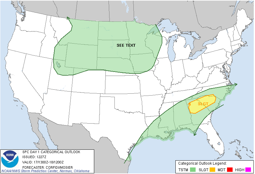
SEVERE WEATHER: Nope. The only severe we'll be seeing today and into tomorrow is severe clear! Bright sunny skies throughout the entire area. There is a "general" risk of thunderstorms across the northern half of the center third of the US, and a "slight" risk of severe weather through Georgia and South Carolina and that's about it for today. Day 2, just a "general" risk of severe storms through the northwestern part of Michigan and a sliver of the upper peninsula, that's it! Here are the Day 1 and Day 2 maps from the Storm Prediction Center, valid at 8AM each day.

Here's the radar image from Grand Rapids with current observations overlaid on it. Remember that circle around the radar site is "ground clutter", buildings and such that show up as radar returns but don't really count.

Now that the foundation is laid, it's time for the local forecast for Jackson and surrounding communities including Parma and Brooklyn.
For today, sunny skies, gentle breezes, a few passing clouds, high near 58 with WNW winds 5-10 MPH.
Tonight, mostly starry skies, some patchy frost is possible, lows near 35, any winds will be NNE calm to 5 MPH.
Wednesday, clear skies, some passing clouds, pleasant, high near 67, winds swing around from the south 10-20 MPH.
Wednesday night, clouds increase, a slight chance of showers late, nighttime low of 51, SW winds roll back to 7-15 MPH.
Thursday, mostly cloudy, perhaps a break or two in the clouds allowing for a peek of sun, periods of rain showers, high temperatures near 67, winds SW 5-10 MPH.
Friday, a near-replay of Thursday but cooler, cloudy, a few breaks in the clouds, chance of showers, high near 55.
Saturday, still cloudy, still a chance of rainshowers, still a high near 55.
Sunday, clouds early, then they FINALLY start to break later in the day, warming to a high of 58.
That's a look at your forecast for this Tuesday, I do hope your day is great! Blessings.
No comments:
Post a Comment