Thursday, June 6, 2013

Clouds & Sprinkles...

Good Morning!

A few peeks of sun break up otherwise cloudy skies that have those scattered showers in them that I mentioned in yesterday's posts.  Here's a look at the current NEXRAD composite:

Visible Satellite with NEXRAD Composite Overlay - light showers in Michigan, heavier activity back in north central Illinois.
Mostly scattered showers, becoming more numerous as you head southwest.  We do note a thunderstorm in the Upper Peninsula near Escanaba.  We'll keep the rain around in fits and starts throughout most of the day, as an upper disturbance works through the area.  Some breaks and thin spots in the clouds will allow for peeks of sun, but that's about it.   Another area of significance is down in the ArkLaTex, where a complex of strong thunderstorms has been wreaking havoc during the night and is poised to move east out of Texas and into Arkansas and Louisiana.

Out in the Gulf Of Mexico, the 2013 hurricane season kicks off with Tropical Storm Andrea up to mischief off the Florida coast.  She's slowly drifting toward the Big Bend, currently moving NNE at 14 MPH with max sustained wind of 60 MPH according to the National Hurricane Center.  She will be a problem for Florida and perhaps Georgia, with flooding and such.  Tornadoes are possible across the southern 2/3 of Florida today, and a Tornado Watch has been posted accordingly by the Storm Prediction Center.  Here's a look at those areas:

Thunderstorms over Texas & Oklahoma, heading into Arkansas and Louisiana, and Tropical Storm Andrea, with her Tornado Watch polygon over Florida.
A fairly benign pattern in place for the next several days.  Here's a look at the forecast for Jackson:


And here's the extended outlook:


Have a great day!

Wednesday, June 5, 2013

Afternoon Update

Good Afternoon!

With a bit of time to look at fresh forecast data, I can tell you that we'll pick up some scattered showers later this evening and during the overnight.  As I said this morning these will be hit & miss, and you're looking at about a 3 in 10 shot at getting wet between now and tomorrow morning.

Here's a look at the current NEXRAD radar composite:


The blog area should expect some scattered showers forming after 7 PM and running through tomorrow mid morning.

Quick Discussion For Wednesday

Good Morning!

Some changes are on the way here in the area, we have one more day of decent weather, clouds start to roll in as the day progresses, then we start to pick up some showers and storms for Thursday and the tail end of the week.  Let's have a look.

TEMPERATURES:  We'll continue to gain ground on the temperature front and get closer to seasonal readings.  Average temperature in this part of the world for this time of year is 78, and computer modeling is indicating that we get there and a bit warmer to start next week.  The GFS forecast model is suggesting 78 for Monday.  No major heat on the horizon that I can see at this point.

RAIN:  We'll see some wet conditions over the next week, but not in the typical fashion.  There will be enough of a chance of rain for me to mention in the forecast, but not so much as to be a good soaker or complete washout.  The rain will be hit or miss in variety, with the best risk tomorrow and Friday, then again on Monday, where we'll be right around the 50/50 mark for showers, with perhaps a lonely thunderstorm moving through.  You can thank an upper disturbance out around Minnesota and western Wisconsin that is currently firing some showers for the clouds we'll see later.  Rain looks to miss us well north, but don't be shocked to see a few showers sneak through later.

SEVERE WEATHER:  Michigan is on the sidelines for the next three days according to the Storm Prediction Center, with just a "general" risk for unorganized thunderstorms tomorrow, stretching in a sliver from Sturgis to Dundee and Monroe.  Have a look at the map for today:

Storm Prediction Center Day 1 Outlook - "slight" risk for eastern New Mexico, over into northern Texas, southern Oklahoma, most of Arkansas, and parts of Missouri, Kentucky, west Tennessee, northern Mississippi and a sliver of Alabama.
As you can see, the threat is concentrated at the south end of Tornado Alley.

We note just a lone shower in West Michigan, crossing 131 near Wayland right now.  Other small showers have popped up southwest of us and tried to head this way, but they dissipated as they headed northeast.

Here's the forecast:

Today, mixed sunshine early, increasing clouds as the day progresses, we can't eliminate the mention of a stray shower, high 74.  Wind E 3-7 MPH.

Tonight, mainly cloudy, still the chance of an isolated shower or two, low 50, wind NE 5-9 MPH.

Thursday, cloudy skies, a couple of lonely showers possible, high 76, wind NE 3-8 MPH.

There's an abbreviated forecast for you, we'll have more detail later on this evening.  Have a great one!

Tuesday, June 4, 2013

Seven Day Outlook

Busy day here as school is winding down for my daughter and I will be out at a sporting event later - so here's the seven day forecast, which includes today at the start.  Thursday on will see some dampness in spots - I don't foresee anything widespread, so don't be surprised to stay dry while a friend or neighbor not far from you picks up some rain.


Have a great Tuesday!

Sunday, June 2, 2013

Cool And Quiet...

Good Evening!

I have been away from the blog for a few days, a lot has  happened in the weather world, if you pay attention to the news and the earlier post on the blog here.  Three researchers/chasers killed Friday night, and a close shave for Mike Bettes from The Weather Channel, when his vehicle was picked up and thrown approximately 200 yards by the the El Reno tornado.  Fortunately, him and all but one of the crew he was with escaped serious harm, suffering only minor injuries.  12 are dead from the latest round of tornadic weather, and I hope that number doesn't go any higher.  It's a sobering reminder that weather will earn your respect - one way or the other.  Here in Michigan we don't expect anything close to that for the next several days.  I wish I could say Oklahoma and Kansas are done with severe weather for awhile, but that's not the case.  More on that in the severe part of this post.  Let's take a deeper dive and see what we have closer to home.

TEMPERATURES:  Unseasonably cool weather has settled into the area as a trough works through.  It's June 2nd, and way up north at the top of the mitten,  at this hour we have readings of 48 in Petoskey and 44 in Gaylord!  Out ahead of the trough, New England is getting some of the severe weather we experienced last week.  Severe storms with hail as far north as Maine today.  Here in our part of the world, just temperatures in the mid 50's with a 62 in Ann Arbor and a 64 in Adrian being the warm spots...


We'll keep these cool readings around for the next couple of days, then start gradually climbing the ladder with respect to temperature.  Readings around the area will remain in the 60's until at least Wednesday or Thursday, when we get back into the lower 70's.  The average temperature in Jackson this time of the year is 77, so the 10-15 degrees below normal we start the work week with is unusual to say the least!  Taking a look at temperatures around the nation, you get a sense of the bigger picture with the ridge/trough setup over the country...


We warm up as that upper air pattern flattens out some, then a ridge starts to build in closer to us, allowing some warmth to filter in, as opposed to the zonal flow we see into mid-week with wind coming in off the Pacific and not mixing with much of anything but perhaps a bit of cool Canadian air.  That change comes in time for the weekend, where we should see highs right around 76, which is refreshing, but cool for the first week of June!

RAIN:  Plenty of clouds right now with not many breaks in them, but no forcing to really bother the atmosphere enough to rain, and not a lot of moisture, with dewpoints sitting in the 50's for the most part.  It's a fairly benign pattern, and we stay in it for the next few days, with the next quality chance at some showers in the area coming on Thursday afternoon.  That being said, on Wednesday and Friday we'll cover the bases by tossing in just the mention of a possible stray shower, but most places should be nice and dry.  I'm fairly sure that the computer forecast models will change the timing of the rain, but from the perch right now, that's where we stand.  Let's look at the Weather Prediction Center's Precipitation map:

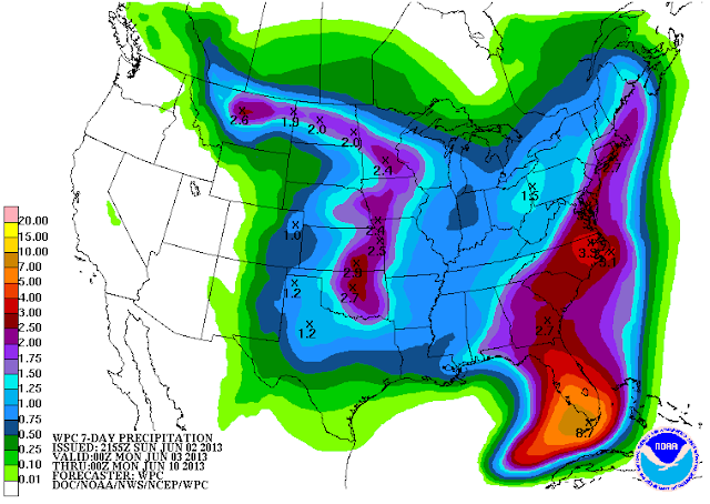
7 Day Precipitation Forecast
As you can see, a fairly dry stretch with just a touch under an inch of rain on the table, and thus far, I can definitely buy that solution with little, if any tweaking needed.

SEVERE WEATHER:  Michigan is on the sidelines for at least the next three to four days regarding severe weather.  I would go out beyond that, but I'm curious to see what may develop with our Wednesday-Friday shot at rain.  I don't expect any bad news up this way, but you never know.  Unfortunately, the storm-weary Plains don't get much a of a break at all, with the Storm Prediction Center showing a "slight" risk for Monday and Tuesday, both days involving Kansas and Oklahoma - North Texas gets a piece of that as well.  Let's pray for Oklahoma, and hope that this threat doesn't verify!

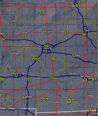
Nothing on the Grand Rapids NEXRAD but ground clutter, plenty of clouds in the area, but a little clearing starting to work in from the southwest:


And here's the forecast for Jackson and surrounding areas including Concord and Grass Lake:

Tonight, clouds early then clearing, unseasonably cold, lows all the way down to 39, wind becoming N and tapering off to 2-5 MPH.

Monday, mainly clear skies with some passing clouds, cool, high only 69, wind N calm to 5 MPH.

Monday night, increasing clouds, not quite as cold, lows near 43.  Wind NE 4-8 MPH.

Tuesday, becoming cloudy, a bit warmer, high 70.  Wind ENE 4-7 MPH.

Wednesday, cloudy, just a small chance of an isolated shower a touch cooler than Tuesday, high 68.

Thursday, continued cloudy, a few scattered showers about, possibly a rumble of thunder, high 70.

Friday, a mix of clouds and some sunshine, we can't rule out a lingering shower over a spot or two, high 73.

Saturday, more sun than clouds, warmer, high 77.

There's a look at your forecast for the next several days, I do hope you had a great Sunday!  Blessings.

We Have Lost Three Special People...

I was hoping that I would not have to use this particular slide again for a LONG time - but with the loss of these three Friday, we are reminded that the quest for knowledge sometimes comes with a hefty price.


The chasing community also remembers their comrades today in North & South Dakota, and Nebraska...

These are the locator beacons of chasers parked on the ground throughout these three states .
They coordinated this to honor the memory of their fallen comrades.
Even though these men didn't make it back to their houses, we can pray they are safely home.  Godspeed gents.  And thank you.