Good Morning!
A pleasant surprise to start the day today - SUNSHINE! I certainly didn't expect to see some quite so soon, but we'll take it! Don't worry though, clouds will return later today. It's looking like the clouds won't be quite as stubborn as originally thought. Let's take a deeper dive.
CHILLY FOR TODAY & PART OF SATURDAY: Cold Canadian prompted Frost Advisories in the area for last night. I hope that your plants came inside or are hardy enough to deal with it! That being said, there's a change to discuss regarding temperatures. Forecast models have reversed course, looking to bring a 60 or two into the area for tomorrow instead of waiting until Sunday. There's an upper low on the satellite picture, sitting over Illinois and Missouri as I write this, with high pressure behind it up closer to Canada. The thinking now is that the low just kind of fades away, but the high pressure behind it gets pulled down into the upper flow, keeping skies clearer than advertised yesterday, allowing sunshine-fueled warming. Behind that, ridging with warm air from the southwest building in. Add 'em up, and you get warmer readings a bit faster than I stated yesterday.
A FAIRLY DRY STRETCH ON THE WAY: Forecast data says we can expect a fairly dry stretch of days to come here in this part of Michigan. South Central Michigan looks pretty quiet, with just some passing clouds and maybe a stray shower this afternoon and tomorrow afternoon. In other words, your typical springtime hit and run PM shower through tomorrow, then a dry stretch if this models have a grasp on things. No severe weather or even thunderstorms to speak of for the next three days in this part of the world.
Here's the forecast:
Today - Mixed sunshine early then becoming cloudy, a couple of stray showers. Chilly, high 53. Wind NW 5-10 MPH.
Tonight - Periods of clouds & stars, perhaps a quick shower. Lows near 35, winds NW 4-8 MPH.
Saturday - Mainly sunny, a bit warmer, some spots could see a stray shower, high 60. Wind WSW 5-10 MPH.
I'll have more detail for you later!
Friday, May 16, 2014
Thursday, May 15, 2014
Gray & Gloomy For Awhile...
Good Morning!
A damp & chilly tail end of the week is in store for Michigan - we'll start recovering early next week if everything plays out as advertised right now. One deeper dive to talk about it all coming up below...
DAMP START TO THE DAY: A good potion of the state awakened to rainy conditions this morning, I expect that to continue later today after the break we're in now, as most of the western half of Michigan is getting a breather from the rain, with the exception of a light shower here and there that radar may have a hard time seeing. Don't expect any change in pattern just yet though, as we'll turn the rain back on with a couple of spotty showers mid-afternoon. Here's the current Tru-Track Doppler radar image:
Current short range data is telling me that the encore shower performance this afternoon should be light and widely scattered. That being said, toss the umbrella in the car with you - I'm thinking the line shown in the radar image may hold together a bit better than the models are saying it will as it comes east.
HOW MUCH RAIN THE NEXT SEVERAL DAYS?: The main low pressure system that brought us storms and the rains today is tracking northeast as I write this. You can pick out the center of the low and where the front is if you look at the radar/satellite composite and check the temperatures, as there's a 8-14 degree swing from warm to cold side. Regarding rain totals, the Weather Prediction Center says that today should about do it for copious rain for awhile. Have a look at the 5 Day Precipitation map...

Rain amounts should stay below a half-inch in Michigan if you're not in the thumb.
WELL BELOW AVERAGE TEMPERATURES FOR AWHILE: As we get this low pressure center, the associated cold front, and the rain through and out of here, Canadian air rolls in on northwesterly winds, keeping us about 20 degrees below normal. Average readings in South Central Michigan are right around 72 degrees. Nights will require a light blanket, with low temperatures flirting with the freezing mark. The forecast models aren't showing me a 70 or better daytime high until next Tuesday!

Now that you know the details, here's the forecast for Jackson and surrounding communities including Grass Lake and Parma:


And here's the extended outlook for us:

Bear in mind that there is a chance of a lone shower or two Friday, even though I didn't put a percentage on the graphic.
I hope you have a wonderful Thursday! Blessings.
A damp & chilly tail end of the week is in store for Michigan - we'll start recovering early next week if everything plays out as advertised right now. One deeper dive to talk about it all coming up below...
DAMP START TO THE DAY: A good potion of the state awakened to rainy conditions this morning, I expect that to continue later today after the break we're in now, as most of the western half of Michigan is getting a breather from the rain, with the exception of a light shower here and there that radar may have a hard time seeing. Don't expect any change in pattern just yet though, as we'll turn the rain back on with a couple of spotty showers mid-afternoon. Here's the current Tru-Track Doppler radar image:
 |
| Plenty of clouds, but a chance to dry out a bit if you're not in the thumb. A fresh line of showers is across the lake and on the move, we'll see how it survives the trip over Lake Michigan. |
HOW MUCH RAIN THE NEXT SEVERAL DAYS?: The main low pressure system that brought us storms and the rains today is tracking northeast as I write this. You can pick out the center of the low and where the front is if you look at the radar/satellite composite and check the temperatures, as there's a 8-14 degree swing from warm to cold side. Regarding rain totals, the Weather Prediction Center says that today should about do it for copious rain for awhile. Have a look at the 5 Day Precipitation map...
Rain amounts should stay below a half-inch in Michigan if you're not in the thumb.
WELL BELOW AVERAGE TEMPERATURES FOR AWHILE: As we get this low pressure center, the associated cold front, and the rain through and out of here, Canadian air rolls in on northwesterly winds, keeping us about 20 degrees below normal. Average readings in South Central Michigan are right around 72 degrees. Nights will require a light blanket, with low temperatures flirting with the freezing mark. The forecast models aren't showing me a 70 or better daytime high until next Tuesday!
Now that you know the details, here's the forecast for Jackson and surrounding communities including Grass Lake and Parma:
And here's the extended outlook for us:
Bear in mind that there is a chance of a lone shower or two Friday, even though I didn't put a percentage on the graphic.
I hope you have a wonderful Thursday! Blessings.
Wednesday, May 14, 2014
Clouds & Cooler...
Good Morning!
We welcome a gray, damp day into the area, and I hate to say, but this is about the last day of seasonable readings in the area until early next week. Let's get right into it and see what's running under the hood:
COLD FRONT IS BY, CHILLY CONDITIONS AHEAD: Yesterday's showers and thunderstorms were out in advance of a strong trough and cold front moving this way from out west. The big picture is a definite ridge/trough/ridge setup with the middle 60% of the US being influenced by the trough digging a ways south into the nation, pulling colder air down from Canada. Jackson made it to 81 officially at the airport yesterday, comparing favorably with my forecast high of 80. We'll give back about 25 degrees of daytime high over the next 24 hours, with the highs today topping out in the low to mid 60's, and a struggle to hold on to the upper 50's until late in the weekend. Your nighttime lows will dip to near freezing over the next few nights! Starting Sunday we begin to see more seasonable air filter in, with readings back into the 60's.
Here's the current temperatures as I write an early morning post for a change:

The readings say it all, but they don't tell you about some...
SHOWERS AND SUCH: This slow moving boundary will bring us periods of showers and perhaps a thunderstorm or two, keeping the skies cloudy and conditions damp today. The main body of storms is off to east and southeast, stretching from western New York, back south through PA, OH, WV, and eventually making it down into Dixie. Those areas are in the standard "slight" risk for severe storms today. Here's that map:

The next piece of the rain train is a strong shortwave located down around the ArkLaTex, organizing itself into a legitimate surface low and coming this way. That arrives as a surface low tomorrow. In front of it, as with most low pressure systems, clouds with rainy conditions. When it gets here, it sits on top of us for awhile, so while there will be an occasional break from rain, clearing doesn't really take hold until tomorrow evening and into Friday.
A few clouds persist from Friday on, and I have to toss in the mention of the chance of a stray shower or two through at least Saturday.
BACK TO MAY-LIKE WEATHER NEXT WEEK: Starting Sunday, we'll see some warmer conditions as the ridge currently sitting just on shore out on the west coast will have started a progression east, elbowing the colder air out of here and bringing back warmer readings, back into the mid and upper 60's.
Here's the forecast for Jackson and surrounding areas including Concord and Rives Junction:


I hope that you have a great Hump Day!
We welcome a gray, damp day into the area, and I hate to say, but this is about the last day of seasonable readings in the area until early next week. Let's get right into it and see what's running under the hood:
COLD FRONT IS BY, CHILLY CONDITIONS AHEAD: Yesterday's showers and thunderstorms were out in advance of a strong trough and cold front moving this way from out west. The big picture is a definite ridge/trough/ridge setup with the middle 60% of the US being influenced by the trough digging a ways south into the nation, pulling colder air down from Canada. Jackson made it to 81 officially at the airport yesterday, comparing favorably with my forecast high of 80. We'll give back about 25 degrees of daytime high over the next 24 hours, with the highs today topping out in the low to mid 60's, and a struggle to hold on to the upper 50's until late in the weekend. Your nighttime lows will dip to near freezing over the next few nights! Starting Sunday we begin to see more seasonable air filter in, with readings back into the 60's.
Here's the current temperatures as I write an early morning post for a change:
The readings say it all, but they don't tell you about some...
SHOWERS AND SUCH: This slow moving boundary will bring us periods of showers and perhaps a thunderstorm or two, keeping the skies cloudy and conditions damp today. The main body of storms is off to east and southeast, stretching from western New York, back south through PA, OH, WV, and eventually making it down into Dixie. Those areas are in the standard "slight" risk for severe storms today. Here's that map:
The next piece of the rain train is a strong shortwave located down around the ArkLaTex, organizing itself into a legitimate surface low and coming this way. That arrives as a surface low tomorrow. In front of it, as with most low pressure systems, clouds with rainy conditions. When it gets here, it sits on top of us for awhile, so while there will be an occasional break from rain, clearing doesn't really take hold until tomorrow evening and into Friday.
A few clouds persist from Friday on, and I have to toss in the mention of the chance of a stray shower or two through at least Saturday.
BACK TO MAY-LIKE WEATHER NEXT WEEK: Starting Sunday, we'll see some warmer conditions as the ridge currently sitting just on shore out on the west coast will have started a progression east, elbowing the colder air out of here and bringing back warmer readings, back into the mid and upper 60's.
Here's the forecast for Jackson and surrounding areas including Concord and Rives Junction:
I hope that you have a great Hump Day!
Tuesday, May 13, 2014
SEVERE THUNDERSTORM WARNING - WASHTENAW
THE NATIONAL WEATHER SERVICE IN DETROIT/PONTIAC HAS ISSUED A
* SEVERE THUNDERSTORM WARNING FOR...
WASHTENAW COUNTY IN SOUTHEAST MICHIGAN...
* UNTIL 330 PM EDT
* AT 236 PM EDT...SEVERE THUNDERSTORMS WERE LOCATED ALONG A LINE
EXTENDING FROM 8 MILES NORTHEAST OF JACKSON TO GRASS LAKE TO
MANCHESTER TO 5 MILES WEST OF CLINTON...AND MOVING NORTHEAST AT 50
MPH.
HAZARD...60 MPH WIND GUSTS.
SOURCE...RADAR INDICATED.
IMPACT...EXPECT DAMAGE TO ROOFS...SIDING AND TREES.
* SEVERE THUNDERSTORMS WILL BE NEAR...
PLEASANT LAKE AND LYNDON TOWNSHIP AROUND 245 PM EDT.
BRIDGEWATER AROUND 250 PM EDT.
MILAN AND HUDSON MILLS METROPARK AROUND 255 PM EDT.
WHITTAKER AND PITTSFIELD TOWNSHIP AROUND 300 PM EDT.
WILLIS AND ANN ARBOR AROUND 305 PM EDT.
DIXBORO AND YPSILANTI AROUND 310 PM EDT.
THE WARNING INCLUDES AREAS SURROUNDING THESE LOCATIONS...
WILLIS... DIXBORO... YPSILANTI...
SALINE... SALEM... MILAN...
MANCHESTER... DEXTER... CHELSEA...
ANN ARBOR...
...<.75IN
WIND...60MPH
Severe Thunderstorm Warning - Livingston
The National Weather Service In Detroit/pontiac Has Issued A
* Severe Thunderstorm Warning For...
Livingston County In Southeast Michigan...
* Until 315 Pm Edt
* At 227 Pm Edt...A Severe Thunderstorm Was Located Near Howell...And Moving Northeast At 55 Mph.
Hazard...60 Mph Wind Gusts.
Source...Radar Indicated.
Impact...Expect Damage To Roofs...Siding And Trees.
* The Severe Thunderstorm Will Be Near...
Hartland And Tyrone Township Around 240 Pm Edt.
The Warning Includes Areas Surrounding These Locations...
Oak Grove... Whitmore Lake... Pinckney...
Howell... Hartland... Hamburg...
Gregory... Fowlerville... Cohoctah...
Brighton...
...<.75in Wind...60mph
I Thought The Calendar Said May...
Good Morning!


After a busy weather day yesterday, things have quieted down somewhat, but they will get busy again in time, with another round of showers and thunder, fortunately not as intense as yesterday. Let's take a deeper dive...
NO HUGE DEAL SEVERE-WISE: Yesterday we were in a "slight" risk for severe weather, and boy did it verify in Washetnaw COunty and points east! Tornado warnings, hail, all of that. Today, things should be much quieter, even if not storm-free. Have a look at the Storm Prediction Center risk map:
 |
| SPC Day 1 Risk Map |
As you can see, just a general risk for garden variety thunderstorms today. That being said, we could see some hail up to pea-size and a some gusty winds as well.
MORNING SUNSHINE, SHOWERS AND A STORM LATER: We note clouds working into the area from the west at this hour on the visible satellite image, as they do, and you combine that with the heating we're getting right now and will continue to get, you can expect some scattered showers and thunderstorms sometime after 2 PM. Even though the air is pretty worked over from all the storms yesterday, thanks to the low-level jet pushing more moisture in ahead of this upper disturbance, it will recover some to support showers and new storms.
A BREAK IN THE ACTION, THEN THE ENCORE: Showers and storms persist into tonight and perhaps as late as morning drive tomorrow, then we see a break in the action until the main weather maker shows up. That's a low tracking northeast from IN/KY/OH, and that's the one that will bring us another round of showers and thunderstorms, but it also bring us sharply cooler weather. I hate to say it, but we are coming to the end of our seasonable weather for a few days. Normal temperatures run into the lower 70's here this time of year, we'll be on the order of 20 degrees cooler! Here's the current temperatures around the nation:
Now have a look at the NAM forecast model futurecast regarding temperatures:
 |
| This is valid Thursday at 8 AM. Nowhere CLOSE to what we're seeing now! |
That's chilly Canadian high pressure! We'll clear the skies and it will feel more like early Spring or even Fall than knocking on the door to Summer with Memorial Day just a couple of weeks away!
RAINS HERE AND THERE: Here's what the Weather Prediction Center thinks regarding rain totals for the next five days:
That's a pretty tight gradient there, showing two things: 1) the better chances for rain and storms will be confined to southeast lower Michigan and 2), those rains will have a bit of intensity with them. Showers and such that form will wring themselves dry fairly effectively over this area. As you track back northwest, the rainfall amounts drop sharply.
Here's the forecast for Jackson and vicinity:
And here's the extended outlook...
Have a great day! Blessings
Monday, May 12, 2014

TORNADO WARNING LIVINGSTON, WASHTENAW
BULLETIN - EAS ACTIVATION REQUESTED
TORNADO WARNING
NATIONAL WEATHER SERVICE DETROIT/PONTIAC MI
318 PM EDT MON MAY 12 2014
THE NATIONAL WEATHER SERVICE IN DETROIT/PONTIAC HAS ISSUED A
* TORNADO WARNING FOR...
SOUTHERN LIVINGSTON COUNTY IN SOUTHEAST MICHIGAN...
NORTHERN WASHTENAW COUNTY IN SOUTHEAST MICHIGAN...
* UNTIL 415 PM EDT
* AT 313 PM EDT...A SEVERE THUNDERSTORM CAPABLE OF PRODUCING A
TORNADO WAS LOCATED NEAR GREGORY...AND MOVING EAST AT 25 MPH.
HAZARD...TORNADO AND QUARTER SIZE HAIL.
SOURCE...RADAR INDICATED ROTATION.
IMPACT...FLYING DEBRIS WILL BE DANGEROUS TO THOSE CAUGHT WITHOUT
SHELTER. MOBILE HOMES WILL BE DAMAGED OR DESTROYED. DAMAGE
TO ROOFS...WINDOWS AND VEHICLES WILL OCCUR. TREE DAMAGE IS
LIKELY.
* THIS DANGEROUS STORM WILL BE NEAR...
HELL AROUND 325 PM EDT.
PINCKNEY STATE RECREATION AREA AND PINCKNEY AROUND 330 PM EDT.
HUDSON MILLS AND HUDSON MILLS METROPARK AROUND 335 PM EDT.
DEXTER AROUND 340 PM EDT.
LAKELAND AROUND 345 PM EDT.
HAMBURG AND DELHI MILLS AROUND 350 PM EDT.
PRECAUTIONARY/PREPAREDNESS ACTIONS...
TAKE COVER NOW. MOVE TO AN INTERIOR ROOM ON THE LOWEST FLOOR OF A
STURDY BUILDING. AVOID WINDOWS. IF IN A MOBILE HOME...A VEHICLE OR
OUTDOORS...MOVE TO THE CLOSEST SUBSTANTIAL SHELTER AND PROTECT
YOURSELF FROM FLYING DEBRIS.
SEVERE THUNDERSTORM WARNING, WASHTENAW, LIVINGSTON
...A SEVERE THUNDERSTORM WARNING IS IN EFFECT FOR NORTHERN
WASHTENAW AND SOUTHERN LIVINGSTON COUNTIES UNTIL 400 PM EDT...
AT 313 PM EDT...A SEVERE THUNDERSTORM WAS LOCATED NEAR GREGORY...AND
MOVING EAST AT 35 MPH.
HAZARD...60 MPH WIND GUSTS AND QUARTER SIZE HAIL.
SOURCE...RADAR INDICATED.
IMPACT...HAIL DAMAGE TO VEHICLES IS EXPECTED. EXPECT WIND DAMAGE TO
ROOFS...SIDING AND TREES.
THE SEVERE THUNDERSTORM WILL BE NEAR...
PINCKNEY STATE RECREATION AREA AND HELL AROUND 325 PM EDT.
HUDSON MILLS AND HUDSON MILLS METROPARK AROUND 330 PM EDT.
LAKELAND AROUND 335 PM EDT.
HAMBURG AND DELHI MILLS AROUND 340 PM EDT.
WHITMORE LAKE AND ISLAND LAKE STATE RECREATION AREA AROUND 345 PM
EDT.
SALEM AROUND 355 PM EDT.
THE WARNING INCLUDES AREAS SURROUNDING THESE LOCATIONS...
DIXBORO... WHITMORE LAKE... SALEM...
PINCKNEY... HOWELL... HARTLAND...
HAMBURG... GREGORY... DEXTER...
CHELSEA... BRIGHTON...
PRECAUTIONARY/PREPAREDNESS ACTIONS...
FOR YOUR PROTECTION MOVE TO AN INTERIOR ROOM ON THE LOWEST FLOOR OF A
BUILDING.
Severe Weather Update...
Here's a look at the current Tru-Track Doppler Radar picture. You see the Severe Thunderstorm Watch until 10 PM EDT shaded in yellow. You also see two active Severe Thunderstorm Warnings - a large one covering the Grand Rapids Metro and points north, and the one for the blog, covering Washtenaw and Livingston Counties.

SEVERE THUNDERSTORM WARNING - JACKSON, INGHAM
THE NATIONAL WEATHER SERVICE IN GRAND RAPIDS HAS ISSUED A

* SEVERE THUNDERSTORM WARNING FOR...
  SOUTHEASTERN INGHAM COUNTY IN SOUTH CENTRAL MICHIGAN...
  NORTHEASTERN JACKSON COUNTY IN SOUTH CENTRAL MICHIGAN...

* UNTIL 315 PM EDT

* AT 244 PM EDT...A SEVERE THUNDERSTORM WAS LOCATED NEAR FITCHBURG...
  AND MOVING EAST AT 35 MPH.

  HAZARD...60 MPH WIND GUSTS AND QUARTER SIZE HAIL.

  SOURCE...RADAR INDICATED.

  IMPACT...HAIL DAMAGE TO VEHICLES IS EXPECTED. EXPECT WIND DAMAGE TO
           ROOFS...SIDING AND TREES.

* LOCATIONS IMPACTED INCLUDE...
  STOCKBRIDGE...        WATERLOO TWP...       MUNITH...
  FITCHBURG...          BUNKER HILL...        WATERLOO...
  MILLVILLE...

PRECAUTIONARY/PREPAREDNESS ACTIONS...

FOR YOUR PROTECTION MOVE TO AN INTERIOR ROOM ON THE LOWEST FLOOR OF A
BUILDING.

LARGE HAIL...DAMAGING WINDS AND CONTINUOUS CLOUD TO GROUND LIGHTNING
IS OCCURRING WITH THIS STORM. MOVE INDOORS IMMEDIATELY. LIGHTNING
KILLS. REMEMBER...IF YOU CAN HEAR THUNDER...YOU ARE CLOSE ENOUGH TO
BE STRUCK BY LIGHTNING.
SEVERE THUNDERSTORM WATCH ISSUED
URGENT - IMMEDIATE BROADCAST REQUESTED
SEVERE THUNDERSTORM WATCH NUMBER 151
NWS STORM PREDICTION CENTER NORMAN OK
245 PM EDT MON MAY 12 2014
THE NWS STORM PREDICTION CENTER HAS ISSUED A
* SEVERE THUNDERSTORM WATCH FOR PORTIONS OF
CENTRAL AND SOUTHERN LOWER MICHIGAN
LAKE ERIE
LAKE MICHIGAN
* EFFECTIVE THIS MONDAY AFTERNOON AND EVENING FROM 245 PM UNTIL
1000 PM EDT.
* PRIMARY THREATS INCLUDE...
ISOLATED DAMAGING WIND GUSTS TO 70 MPH POSSIBLE
ISOLATED LARGE HAIL EVENTS TO 1.5 INCHES IN DIAMETER POSSIBLE
THE SEVERE THUNDERSTORM WATCH AREA IS APPROXIMATELY ALONG AND 50
STATUTE MILES NORTH AND SOUTH OF A LINE FROM 10 MILES SOUTHWEST
OF MUSKEGON MICHIGAN TO 15 MILES NORTHEAST OF DETROIT MICHIGAN.
FOR A COMPLETE DEPICTION OF THE WATCH SEE THE ASSOCIATED WATCH
OUTLINE UPDATE (WOUS64 KWNS WOU1).
PRECAUTIONARY/PREPAREDNESS ACTIONS...
REMEMBER...A SEVERE THUNDERSTORM WATCH MEANS CONDITIONS ARE
FAVORABLE FOR SEVERE THUNDERSTORMS IN AND CLOSE TO THE WATCH
AREA. PERSONS IN THESE AREAS SHOULD BE ON THE LOOKOUT FOR
THREATENING WEATHER CONDITIONS AND LISTEN FOR LATER STATEMENTS
AND POSSIBLE WARNINGS. SEVERE THUNDERSTORMS CAN AND OCCASIONALLY
DO PRODUCE TORNADOES.
&&
Noisy, Blowhard Storms Later...
Good Morning!
A potentially busy day for us here in South Central Michigan so let's have a look and see what's cooking!
RIGHT NOW: Plenty of shower and thunderstorm activity to be had - here's Tru-Track Doppler:

You can see the broken line of storms stretching from Adrian back northwest up to Big Rapids.
SEVERE WEATHER CHANCES: The Storm Prediction Center has placed us into the standard "slight risk for severe weather. Here's a look at the detail on that:

Thankfully, no moderate risks on the map like there were yesterday, resulting in several tornadoes across Nebraska and Kansas. The primary threats from these storms for us later today will be small hail, gusty straight line winds and locally heavy rains.
I will have a detailed forecast for you by 1 PM!
A potentially busy day for us here in South Central Michigan so let's have a look and see what's cooking!
RIGHT NOW: Plenty of shower and thunderstorm activity to be had - here's Tru-Track Doppler:
You can see the broken line of storms stretching from Adrian back northwest up to Big Rapids.
SEVERE WEATHER CHANCES: The Storm Prediction Center has placed us into the standard "slight risk for severe weather. Here's a look at the detail on that:
Thankfully, no moderate risks on the map like there were yesterday, resulting in several tornadoes across Nebraska and Kansas. The primary threats from these storms for us later today will be small hail, gusty straight line winds and locally heavy rains.
I will have a detailed forecast for you by 1 PM!
Sunday, May 11, 2014
Potential For Severe Weather Today & Tomorrow
Good Afternoon!
Happy Mother's Day to any moms reading this!
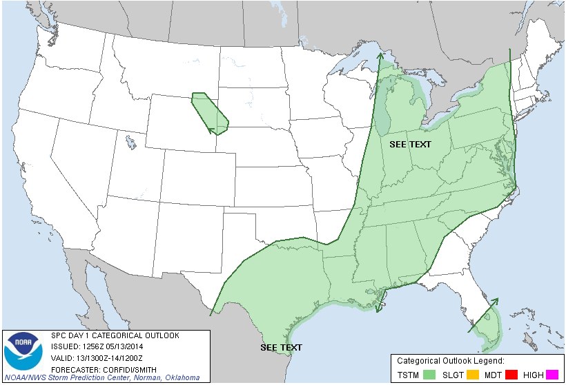
Let's get right to it - the next couple of days you need to be weather savvy here in South Central Michigan, with the threat of severe weather including possibly a tornado in the picture. I'll let the maps do the talking for me:
 |
| Storm Prediction Center Risk Outline |
 |
| Current Watch Map as of 4:30 EDT |
 |
| SPC Day 2 Risk Outline - note that basically the entire lower 2/3 of Michigan is in play for this one. |
Forecast is forthcoming. All of you Moms, enjoy the balance of your day!
Subscribe to:
Posts (Atom)