Good Afternoon!
The end of summer is upon us, and with it, a warm Labor Day holiday. One final chance to swim or boat, or partake in any of a number of outdoor activities. School starts in most areas in the South Central Michigan Weather Zone tomorrow (my daughter is no exception), so let's get in there and see what's under the hood for Labor Day 2012 and Back To School!
TEMPERATURES: We'll see temperatures stay up in the summer-like readings, with temperatures in the mid 80's until Wednesday or Thursday and heading into the weekend, because computer modeling suggests a trough works into the area, and under that, fall will blow in with northerly winds and temperatures that will have to work to get to 75. Average temperature this time of year is 75, so we'll run right about average when you factor in the warm readings from the early part of the week.
RAIN: Right now, the forecast models are suggesting multiple chances of rain for the next several days, the good news is that any showers that do occur will be light, primarily afternoon and evening affairs, and have plenty of space between showers, at least until we get to midweek and Thursday (more on that below). Here's a look at the forecast map from the National Weather Service (NWS) for the next five days...
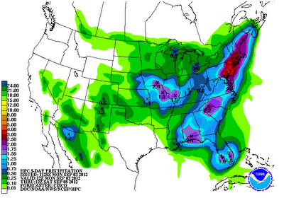 |
| 5 Day Precipitation Forecast |
Not a very wet look for this part of the state, this NWS forecast suggests a quarter-inch tops. That looks about right for the most part, I could see some areas picking up closer to a half-inch of precipitation though. Right now, we'll introduce a chance of isolated to widely scattered showers roughly every other day starting tomorrow and going through the weekend. Any given spot looks to have maybe a 30-40% chance of rain, with a little less spacing in the north zone than south.
SEVERE WEATHER: Nothing much but a "general" risk of thunderstorms - until you get to Wednesday, which is Day 3. The Storm Prediction Center has most of the Lower Peninsula under a "slight" risk for severe weather. Here's a look at that map for you:
 |
| Severe Weather Outlook Day 3, Valid 8AM Wednesday |
Wednesday is about the time that the trough will move across Michigan, and according to SPC, a surface cold front should be in the area also, setting the stage for some showers and thunderstorms that could be severe, depending on the quality of the air on Wednesday. We'll keep an eye on that as we get closer to hump day.
Grand Rapids NEXRAD is snoring with nothing to see besides ground clutter. Here's the visible satellite image, basically crystal clear across the Lower Peninsula:
 |
| Visible Satellite Picture |
Here's the forecast for Jackson and surrounding communities including Rives Junction and Parma:
Labor Day, Mostly sunny, clouds start to thicken some later, warm, high 85, winds ESE 5-10 MPH.
Tonight, periods of clouds and stars, low 64, winds ESE 3-8 MPH.
Tomorrow, mixed sunshine, breezy, continued warm, a chance of a stray isolated shower in the afternoon, high 83, winds N 4-9 MPH.
Tuesday night, some passing clouds, mild, low 63, winds SW 3-6 MPH.
Wednesday, partly cloudy skies, not as warm, chance of afternoon showers or thunderstorms, high 78.
Thursday, mainly clear skies, a few clouds in the afternoon, possibly an isolated shower, high 76.
Friday, periods of clouds and sunshine, cooler, a stray afternoon shower can't be ruled out, high 73.
Saturday, partly to mostly sunny, some clouds pass by during the day, high 72.
Sunday, sunny, cooler, high 71.
There's a look at your forecast for the next six days, I do hope that you have a great day! Blessings.


