Good Evening. The National Weather Service has issued a Wind Advisory for all counties in the South Central Michigan Weather Zone for winds 20-30 MPH gusting to 45 or better. Use caution when traveling.
Saturday, January 19, 2013
Mild, then BAM! Everyone Freezes!
Good Morning!
Just looking at some forecast data here while the place is quiet. Big changes and big snow on the way in some parts of Michigan, let's have a look:
SUMMARY: As I write this at 1 AM, all quiet in the Lower Peninsula of Michigan. A low is currently causing some light snow in the Upper Peninsula, and that should be gone by lunchtime tomorrow. Temperatures climb to unseasonably warm 40's in this part of Michigan. The changes come Saturday night as Arctic air kicks in the door and drops temperatures to teens and single digits. Both the GFS and NAM forecast models agree that a pretty solid 1000 millibar low tracks across the upper part of the mitten, bringing significant snow up that way. More on snow below. Temperatures stay bitterly cold through most of next week, not even coming close to freezing. We spend more time near zero during the nights than anything!
SNOW: Taking a look at forecast data and such, I will say the models seem to like a slight chance of snow on Monday and Wednesday, but at this point, I don't buy it. In South Central Michigan, we won't have lake effect to worry with, so with it being so cold, you don't have much of a trigger to create clouds or snow, like icy air blowing over the warmer waters of Lake Michigan. Now up north where the low should track, and over on the lake shore, there will be snow issues. Bear that in mind if you need to go up by Mt. Pleasant or points north, or west of US-131 tomorrow evening or Sunday. The National Weather Service says a quarter-inch of liquid precipitation between now and 7 PM Thursday, and that looks about right, meaning I would be surprised to see much more than 2" snow total over the next several days. Of course, if strong winds can push the lake effect snow bands well inland, we could see more than forecast, especially west.
Complete forecast later.
Thursday, January 17, 2013
Quiet, Warming Until Saturday...
Good Morning!
A blend of clouds and sun in South Central Michigan at this hour, at least until you get into the southern tier of counties along the state line, where it is mainly clear right now with temperatures at or near 30 across the board. The clouds in the north zone are thanks to some lake-effect snow off to the northwest that is affecting mainly Muskegon, Big Rapids and areas on over to Mount Pleasant. Let's take a deeper dive and see what we have going in this part of the world:
SUMMARY: Fairly quiet in the area now and for the next few days, with a warming trend until Saturday evening,then to bottom falls out of the thermometer and we get shoved into the freezer. Expect temperatures to fall almost 25 degrees and settle in the teens or low 20's in most places for Sunday.
We'll see an unseasonably mild high of 40 tomorrow, after we make it to about 30 today, so don't expect a whole lot of movement of the mercury today. The quick warming happens as we get to the back side of a high that is riding in the jet stream, which is currently running right over Michigan. That high has wind spinning clockwise around itself while it moves within the bigger and faster jet stream, so as it moves to the north of us, it will make the winds near the surface swing to the southwest, pulling milder air up from the south.
That all passes us, then winds swing back northwest, and the cold air kicks the door in and rushes us, sending the mercury toward zero over night early next week. Look at this map of surface temperatures:

If you're looking for any temperatures above freezing, forget about it through the end of next week.
PRECIPITATION: Based on what I just explained above, I really don't see much falling out of the sky in this area, with the exception of maybe a few flurries when the cold air barrels in Saturday night. If you're headed over to West Michigan, you'll want to tuck away in mind the chance of some lake-effect snow from US-131 west to the shore, but other than that, for my money, we stay quiet. Take a look at this map, which is the National Weather Service precipitation forecast map for the next five days:
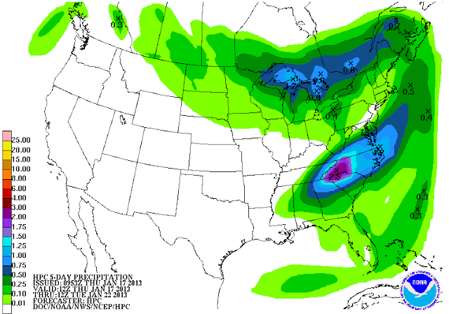
As you can see, a quarter inch of liquid tops for the next five days, and I can buy that. You have to remember that computer forecast models don't do all that well with things like lake-effect snow, because the ingredients that have to be in the pot to make that happen are so precise. This is the forecast models saying we see low risk for snow and we can't get more specific than that.
Here's the satellite and Grand Rapids NEXRAD images:
And here's the forecast for Jackson and surrounding areas including Parma and Vandercook Lake:
Today, periods of clouds and sun, seasonable, high 35, winds NW 6-12 MPH.
Tonight, partly to mostly cloudy skies, cold, lows near 16, wind SW 7-14 MPH, wind chills could reach -2 in some areas!
Friday, more clouds than sunshine, windy, with a high of 34, wind SW 10-20 MPH, wind chills will stay around 20 degrees.
Friday night, mainly cloudy, not as cold, low near 27. Wind SW 10-20 MPH, wind chills near 10 degrees are likely.
Saturday, partly sunny, unseasonably mild, high 40.
Sunday, some mixed sunshine, sharply colder, perhaps a few flurries as the cold air pours in, high 20.
Monday, partly to mostly cloudy skies, colder still, high only 15. Nighttime wind chills could reach or exceed -10.
Tuesday, continued partly cloudy, just a touch warmer, a few stray flurries may be about, high only 16.
Wednesday, clouds persist with some breaks for sunshine, a few degrees warmer again, high climbs to 22.
Thursday, a mix of clouds and sunshine, back to seasonable conditions, high 30.
There's a look at your forecast for the next six days, I do hope that you have a great day! Blessings.
A blend of clouds and sun in South Central Michigan at this hour, at least until you get into the southern tier of counties along the state line, where it is mainly clear right now with temperatures at or near 30 across the board. The clouds in the north zone are thanks to some lake-effect snow off to the northwest that is affecting mainly Muskegon, Big Rapids and areas on over to Mount Pleasant. Let's take a deeper dive and see what we have going in this part of the world:
SUMMARY: Fairly quiet in the area now and for the next few days, with a warming trend until Saturday evening,then to bottom falls out of the thermometer and we get shoved into the freezer. Expect temperatures to fall almost 25 degrees and settle in the teens or low 20's in most places for Sunday.
We'll see an unseasonably mild high of 40 tomorrow, after we make it to about 30 today, so don't expect a whole lot of movement of the mercury today. The quick warming happens as we get to the back side of a high that is riding in the jet stream, which is currently running right over Michigan. That high has wind spinning clockwise around itself while it moves within the bigger and faster jet stream, so as it moves to the north of us, it will make the winds near the surface swing to the southwest, pulling milder air up from the south.
That all passes us, then winds swing back northwest, and the cold air kicks the door in and rushes us, sending the mercury toward zero over night early next week. Look at this map of surface temperatures:

If you're looking for any temperatures above freezing, forget about it through the end of next week.
PRECIPITATION: Based on what I just explained above, I really don't see much falling out of the sky in this area, with the exception of maybe a few flurries when the cold air barrels in Saturday night. If you're headed over to West Michigan, you'll want to tuck away in mind the chance of some lake-effect snow from US-131 west to the shore, but other than that, for my money, we stay quiet. Take a look at this map, which is the National Weather Service precipitation forecast map for the next five days:

As you can see, a quarter inch of liquid tops for the next five days, and I can buy that. You have to remember that computer forecast models don't do all that well with things like lake-effect snow, because the ingredients that have to be in the pot to make that happen are so precise. This is the forecast models saying we see low risk for snow and we can't get more specific than that.
Here's the satellite and Grand Rapids NEXRAD images:
 |
| Visible Satellite Image |
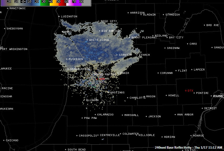 |
| Grand Rapids NEXRAD Radar Reflectivity |
Today, periods of clouds and sun, seasonable, high 35, winds NW 6-12 MPH.
Tonight, partly to mostly cloudy skies, cold, lows near 16, wind SW 7-14 MPH, wind chills could reach -2 in some areas!
Friday, more clouds than sunshine, windy, with a high of 34, wind SW 10-20 MPH, wind chills will stay around 20 degrees.
Friday night, mainly cloudy, not as cold, low near 27. Wind SW 10-20 MPH, wind chills near 10 degrees are likely.
Saturday, partly sunny, unseasonably mild, high 40.
Sunday, some mixed sunshine, sharply colder, perhaps a few flurries as the cold air pours in, high 20.
Monday, partly to mostly cloudy skies, colder still, high only 15. Nighttime wind chills could reach or exceed -10.
Tuesday, continued partly cloudy, just a touch warmer, a few stray flurries may be about, high only 16.
Wednesday, clouds persist with some breaks for sunshine, a few degrees warmer again, high climbs to 22.
Thursday, a mix of clouds and sunshine, back to seasonable conditions, high 30.
There's a look at your forecast for the next six days, I do hope that you have a great day! Blessings.
Wednesday, January 16, 2013
Back Into The Freezer This Weekend...
Hello!
As promised, I have a six day forecast for you. Enjoy the mild weather on Saturday - you'll need the extra blankets and warm jackets for Sunday and into next week!

Have a great evening!
As promised, I have a six day forecast for you. Enjoy the mild weather on Saturday - you'll need the extra blankets and warm jackets for Sunday and into next week!

Have a great evening!
Some Clouds, Some Warming...
Good Afternoon!
Plenty of sunshine in South Central Michigan at this hour, we'll see some clouds and a few changes though. Time to dive right in and see what we have going on for you:
SUMMARY: A touch of an upper disturbance in the area just off to the northwest of us at this hour, it's currently bringing a bit of light snow to the northwest quadrant of the Lower Peninsula. Not much in this area to mention.
Low to mid 30's the rule of thumb in the area. A warm-up in on the way, culminating in a high near 41 on Friday, then the door opens, and we see bitterly cold Canadian air filter in, putting us back in the freezer and daytime high temperatures top out below 20.
PRECIPITATION: Things are looking pretty quiet between now and Sunday, when the temperatures plummet back into the truly winter levels. Perhaps just the chance of a few flurries or some freezing precipitation Saturday evening into Sunday as the cold air filters in. Let's take a look at the five day precipitation outlook from the National Weather Service:
As you can see, perhaps a small chance each day of a few snowflakes around the area. What we have with this setup is a shallow trough aloft and the jet stream is sitting pretty much over us. There are a few disturbances embedded in that flow, so as a result, we get a shot at some snow. One looks like it will get into the area Friday evening and into the wee hours of Saturday, but that one should stay north of us here. A second little wave comes through about the same time Saturday night, forecast modeling is suggesting that some lake-effect snow could fall, and it may just barely brush us with a dusting or a light coating. Let's look at the forecast for you:

I will be working on an update and six day forecast for you. I hope that you have a great day!
Plenty of sunshine in South Central Michigan at this hour, we'll see some clouds and a few changes though. Time to dive right in and see what we have going on for you:
SUMMARY: A touch of an upper disturbance in the area just off to the northwest of us at this hour, it's currently bringing a bit of light snow to the northwest quadrant of the Lower Peninsula. Not much in this area to mention.
Low to mid 30's the rule of thumb in the area. A warm-up in on the way, culminating in a high near 41 on Friday, then the door opens, and we see bitterly cold Canadian air filter in, putting us back in the freezer and daytime high temperatures top out below 20.
PRECIPITATION: Things are looking pretty quiet between now and Sunday, when the temperatures plummet back into the truly winter levels. Perhaps just the chance of a few flurries or some freezing precipitation Saturday evening into Sunday as the cold air filters in. Let's take a look at the five day precipitation outlook from the National Weather Service:
 |
| 5 Day Precipitation Totals, Valid thru 8 AM Monday Jan 21st |

I will be working on an update and six day forecast for you. I hope that you have a great day!
Monday, January 14, 2013
Winter Is Back...
Good Morning!
Just a quick look at today and tonight for you. I hope to have a detailed summary for you later this evening. I will tell you that now that the wintry mix has left the area, bitterly cold air is poised to move in from west of us. Aside from an occasional flurry, we'll stay fairly snow-free, with the exception of a few Alberta Clippers embedded in the upper flow coming through and bugging the atmosphere enough to touch off some snow now and again. Forecast modeling indicates we have a crack at snow on Wednesday evening into Thursday, then we'll see a more substantial chance on Saturday. Temperatures remain below freezing, except on Wednesday and Saturday.
Here's the forecast for today:


Have a great day!
Just a quick look at today and tonight for you. I hope to have a detailed summary for you later this evening. I will tell you that now that the wintry mix has left the area, bitterly cold air is poised to move in from west of us. Aside from an occasional flurry, we'll stay fairly snow-free, with the exception of a few Alberta Clippers embedded in the upper flow coming through and bugging the atmosphere enough to touch off some snow now and again. Forecast modeling indicates we have a crack at snow on Wednesday evening into Thursday, then we'll see a more substantial chance on Saturday. Temperatures remain below freezing, except on Wednesday and Saturday.
Here's the forecast for today:


Subscribe to:
Posts (Atom)