
Saturday, December 21, 2013
Current Conditions
Here's a look at current temps and such in the area, as well as what's going on weather alerts wise:

Storm Update #1
Good Afternoon!
Here's a look at the current composite on Tru-Track Doppler:

As you can see, still rain in Jackson, some mixed precip setting up north of here though. Stay aware, as these conditions will start to change very quickly as the afternoon progresses.
Here's a look at the current composite on Tru-Track Doppler:

As you can see, still rain in Jackson, some mixed precip setting up north of here though. Stay aware, as these conditions will start to change very quickly as the afternoon progresses.
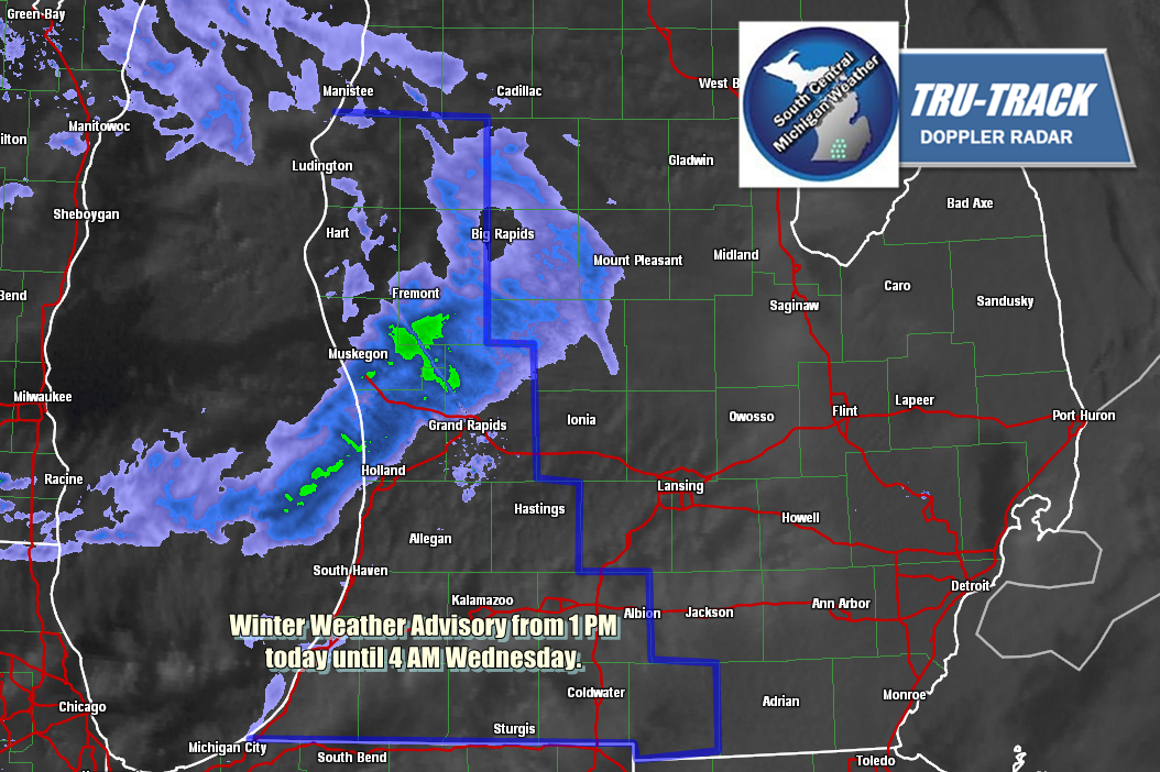
TRICKY TRAVEL AHEAD....
Have to work the straight job today, but you need to know there's an Ice Storm Warning for parts of the blog. Here's the forecast for Jackson & vicinity:


More coming later!


More coming later!
Friday, December 20, 2013

WEATHER ADVISORIES & UPDATED FORECAST
Good Morning!
Changes to the forecast and weather advisories to note:
DENSE FOG ADVISORY - Branch, HIllsdale - until 10 AM.
WINTER WEATHER ADVISORY - Eaton, Ingham, Clinton, Shiawassee, until 7 PM this evening now, for freezing rain causing icing up to a quarter-inch.
Here's the updated forecast for us primarily below Lansing:


More updates later! Have a good day.
Mainly Wet - Mix It Up Later?
Hello Again.
With a chance to look at fresh data now that everyone is in bed and the event has started, let's try to unravel some of these mysteries.
WEATHER ADVISORIES TO NOTE: The National Weather Service has issued a Winter Weather Advisory for Clinton and Shiawassee counties for a wintry mix of precipitation that will be in the area until late morning tomorrow. The advisory expires at 1 PM tomorrow afternoon. There will be ongoing snow and freezing rain or sleet. Basically all modes of winter precipitation are possible in this area.
SO WHAT WILL WE HAVE, RAIN, OR SNOW? I say both. Right now, it's rain, and it will stay that way for awhile. I don't see the temperatures falling below freezing until tomorrow late evening, and by that time the lion's share of precipitation will have worked out of the area. A surface boundary is stalled literally two counties north. Anything in the cold sector gets snow or something similar. We, thankfully are in the warm sector and temperatures support rain. Now as the boundary gets pushed to the south and we get falling temperatures, expect a changeover to mixed precipitation and then some snow. I don't foresee a huge accumulation from this, maybe an inch or a touch more. Here's a look at the current radar composite:

As you can see, not much elbow room between us and that wintry precipitation!
LOOKING AHEAD TO THE WEEKEND: We get this little bit of disturbance out of here and have a bit of time before the big system shows up on Saturday evening into Sunday. Right now it's an evolving low way out in southern California and into Baja Mexico. The next 12 hours should see it cross entirely into the US and then we can get a good look at it, poking and prodding to get a feel for where it's going to go and what it will do. Forecast models have it tracking thru Texas, Oklahoma, Arkansas and Missouri, ending up on our doorstep late Sunday. Right now, the data suggests temperatures that support rain. Sunday night into Monday, as that thing passes by, I see it dragging a cold front that will put us back into snow and falling temperatures.
Here's the forecast for Jackson and vicinity:


Have a great one. We'll update you as the day progresses.
Thursday, December 19, 2013
Time To Reach Into The Grab Bag...
Good Morning!
We may actually thaw out some! Temperatures are ABOVE FREEZING for the first time in recent memory. All of the snow we have on the ground will become good snowball snow for the kids, and some of it will melt. Let's jump right in and have a look.
WARMER CONDITIONS THE NEXT COUPLE OF DAYS: The upper air pattern reset that I alluded to is taking place as I write. No more cold Arctic air diving down into the area from Canada. This look is much more zonal, with a straight east/west flow coming off the desert out in Arizona and New Mexico. What does that mean for us? It's now warm enough to melt off some snow and anything that falls from above would have a good chance at being rain or a wintry mix. That being said, the break point between rain and snow is not very far north of us at all!
WHAT ABOUT THE STORM SYSTEM MIKE?: This is where I would earn my money as a forecaster if this were a paying gig. Let's try it. Multiple models have slowed down the arrival of the boundary, making it more of a late evening/overnight affair. From what I see, I'm calling rain over the southern half of the blog, and snow or mixed precipitation through the northern counties. Let me stress one thing - we are close enough to where the computers are saying the core of the boundary will track that the south half of Calhoun, Jackson and Washtenaw counties could see rain and the north half of the counties snow. It's THAT close. That will continue into tomorrow and the weekend. I'll have to dig in and see what it looks like next forecast model run.
LOOKING AHEAD: The weekend looks to be a mixed bag, then we shift back into snow mode, with a potential storm on tap to ensure a white Christmas for us here in this part of the world.
Here's my forecast:


Have a great day!
Tuesday, December 17, 2013
WINTER WEATHER ADVISORY - CALHOUN, BRANCH, HILLSDALE
Have a look at the latest advisory from the National Weather Service - I had to draw it in on a still graphic from Tru-Track Doppler, so I apologize for the somewhat crude look.

If you're inside the shadowed blue line, you're in play for this one. The radar currently shows some snow in the area now, that will scoot out of here until another Clipper makes a pass this way later today, dropping more snow.
If you're inside the shadowed blue line, you're in play for this one. The radar currently shows some snow in the area now, that will scoot out of here until another Clipper makes a pass this way later today, dropping more snow.
A Look Down The Line...
Good Morning!
While I figure out what the heck is going on with my forecasting (0 for 2 in this racket isn't a good thing at all), I will show you what we can expect heading into the weekend. Why should you trust it? I'm up front and admit when I screw it up, and I also checked this forecast very closely against multiple data sources. They all bear out this big picture pretty much in this order - it's the timing and the precipitation type later in the week that are the sticky points. Have a look:

Detailed forecast is in the process!

Monday, December 16, 2013
A Little Off The Top - Courtesy Of A Clipper...
Hey Gang!
Have a look at the latest Tru-Track Doppler radar picture - it shows the clipper that will impact Michigan until about 2 AM or so. If you're traveling home from work, please be careful and allow extra time.

Have a great evening!
Have a look at the latest Tru-Track Doppler radar picture - it shows the clipper that will impact Michigan until about 2 AM or so. If you're traveling home from work, please be careful and allow extra time.

Have a great evening!
Afternoon Update
Hey Gang!
Just taking a look at some fresh forecast data and I needed to let you know that the changes I made to the forecast this morning look to be the right ones. The snow will still get here, but from what I can see now it should not affect your trip home from work. This would be an issue for folks that work second shift and get out at 10 or 11 PM. There could be some snow in the area, which would make for slick roads if left untreated.
Amounts still look OK, about an inch or a bit more, I still think the I-94 corridor needs to be careful, as along and south of there looks like a quick shot of intense snow could fall. I'll have more for you this evening as we finish off the drive home.
No Clouds, Slower Snow...
Good Morning.
Dangit! I busted on the forecast for this morning. I was thinking cloudy skies, and we have bright blue skies and very cold this morning for the wake-up. OK. Fair enough. I need to re-examine what the models were saying and why I didn't pick up on the fact that we wouldn't have much regarding clouds this morning. That in turn would have caused me to lower the temperature prediction. No clouds = no blanket to keep daytime heating close to the surface. Moving on...
HEY CLIPPER - I SEE YOU: The disturbance that will bring us our next snow maker, likely this evening/tonight, is parked up in the northern half of Minnesota right now. Forecast model data is suggesting that it will be a bit slower than previously thought, so the snow should come through well after you've gotten home for the evening. The track and amounts still look OK though, about an inch in most areas give or take, perhaps a touch more in the snow box.
I'll have more detail later on today, but here's the forecast right now for Jackson and surrounding areas including Michigan Center and Spring Arbor:


I hope you have a great day. A lot of schools in the area, especially those that serve rural populations, have called 2 hour delay or snow day today, check the previous post for the list, then check local media for any updates I may have missed. Blessings!
Sunday, December 15, 2013

SCHOOL CLOSINGS
Hey Gang -
Just a heads up to let you know that there are a couple of school closings for tomorrow. Have a look:

Have a great one!
Just a heads up to let you know that there are a couple of school closings for tomorrow. Have a look:

Have a great one!
A Bit More Snow, Then Changing...
Good Evening!
Forecaster Mike here, still getting back into the swing of things with the blog. The two job bit is pretty much a done deal, so we'll be getting back to some semblance of a normal daily schedule soon. A lot to talk about so let's take a dive into it...
THE CHILLY AIR STAYS AROUND (FOR AWHILE LONGER): Have a look at temperatures in the country.

That cold trough and the Arctic air from Canada is still hanging tough. I love my Canadian neighbors, but that mess, they can take and keep north of the border! You can see milder air has split the big trough into two pieces, with a pocket of cold air over the Rockies, and the rest of the trough to the east of that. There is some change down the line a bit though, keep reading. Now let's talk about....
OUR FIRST WINTER STORM HAS COME AND (PRETTY MUCH) GONE: Even though it's gone, there's still plenty of lake effect snow to be had in this part of the world. A Winter Weather Advisory will be on the board for Calhoun County and points west until 7 PM for lake effect snow that could tack as much as an additional four inches onto the snowfall totals in t-hat part of the world. It is snowing still here in Jackson County, but our accumulations will only be about an additional inch. Let's have a look at the snow totals:
 As I said, plenty of snow to go around. That will continue into the week, as taking a look at model data, I'm seeing...
A BIT MORE SNOW, CLIPPER-STYLE: Forecast models are showing a couple of upper disturbances that will come through and give us more snow. These things are fast-moving, hit and run type deals, you may hear a meteorologist on TV or radio use the phrase "Alberta Clipper". That's because these are buried in the larger upper level flow, they ride into the area, create a bit of snow, then keep on cruising. Timing is fairly consistent from model to model, in that fairly late Monday afternoon, into the evening, a shot of snow works into the area, exiting by daybreak Tuesday. Have a look at this graphic:
Another upper disturbance looks to drop in here right on the heels of that one, it could give us some snow as well. I have seen model spread on the Tuesday affair concerning arrival time as soon as just after morning drive, to as late as second shift drive (3 PM). I'm going to split the difference, and go with an hour or two either side of lunchtime as when you should expect a bit of snow. I don't expect Tuesday's ride home to have much in the way of weather difficulty in it. I'm thinking another two inches of new snow between the two events, maybe a touch more, let's see what the Weather Prediction Center thinks about the next five days regarding precipitation:
Once we get through midweek, a pattern shift and warming trend start to take shape. This pattern change means...
THE COLD STUFF GETS SHOVED BACK NORTH: We'll see the icy Arctic air get shoved back north of the border, temperatures here climb above freezing and beyond, and the precipitation that falls from above would be RAIN, not snow. Current model solutions are suggesting a high of 40 in Jackson on Thursday. I personally think that's a bit ambitious, but 35-38 certainly isn't out of the picture. I'll hold any further judgment until the models crunch new data a few times and see what number they suggest on the guidance printout.
We come back down to just under the average high of 33 in time for the weekend, and leave in a chance of some flurries or light snow right through the forecast window.
LOOKING AHEAD: All of you white Christmas aficionados should have little or nothing to worry about. We don't stay warm long enough to melt the snow that we got Saturday, plus we have additional snowfall that accumulates through the week before the warm up gets here. In fact, the GFS forecast model suggests that Santa will have a storm center over northern lower Michigan to contend with on Christmas Eve, with temperatures supporting snow in the area. We'll evaluate that as we get closer to Christmas. Still many days before we get there, but from the perch now, more than enough white stuff for you.
Here's the forecast for Jackson and surrounding areas including Parma and Brooklyn:


 There's a look at your forecast for the next week. Have a great evening! Blessings.
Forecaster Mike here, still getting back into the swing of things with the blog. The two job bit is pretty much a done deal, so we'll be getting back to some semblance of a normal daily schedule soon. A lot to talk about so let's take a dive into it...
THE CHILLY AIR STAYS AROUND (FOR AWHILE LONGER): Have a look at temperatures in the country.
That cold trough and the Arctic air from Canada is still hanging tough. I love my Canadian neighbors, but that mess, they can take and keep north of the border! You can see milder air has split the big trough into two pieces, with a pocket of cold air over the Rockies, and the rest of the trough to the east of that. There is some change down the line a bit though, keep reading. Now let's talk about....
OUR FIRST WINTER STORM HAS COME AND (PRETTY MUCH) GONE: Even though it's gone, there's still plenty of lake effect snow to be had in this part of the world. A Winter Weather Advisory will be on the board for Calhoun County and points west until 7 PM for lake effect snow that could tack as much as an additional four inches onto the snowfall totals in t-hat part of the world. It is snowing still here in Jackson County, but our accumulations will only be about an additional inch. Let's have a look at the snow totals:

A BIT MORE SNOW, CLIPPER-STYLE: Forecast models are showing a couple of upper disturbances that will come through and give us more snow. These things are fast-moving, hit and run type deals, you may hear a meteorologist on TV or radio use the phrase "Alberta Clipper". That's because these are buried in the larger upper level flow, they ride into the area, create a bit of snow, then keep on cruising. Timing is fairly consistent from model to model, in that fairly late Monday afternoon, into the evening, a shot of snow works into the area, exiting by daybreak Tuesday. Have a look at this graphic:
 |
| I'm fairly confident we see snow both Monday and Tuesday. From this look, for my money, Monday will be the bigger hassle as far as travel. Heavier snowfall along and south of I-94 for the drive home. |
 |
| WPC likes between a quarter to a half-inch of liquid precipitation through 7 PM Saturday night. Using the rule of thumb that an inch of liquid gets you about a foot of snow, this looks OK to me. I think we pick up maybe two inches of snow early in the week, so that means a bit less than .25 inch of liquid, then don't be shocked to see some rain on Thursday to bring us up to these suggested totals. |
THE COLD STUFF GETS SHOVED BACK NORTH: We'll see the icy Arctic air get shoved back north of the border, temperatures here climb above freezing and beyond, and the precipitation that falls from above would be RAIN, not snow. Current model solutions are suggesting a high of 40 in Jackson on Thursday. I personally think that's a bit ambitious, but 35-38 certainly isn't out of the picture. I'll hold any further judgment until the models crunch new data a few times and see what number they suggest on the guidance printout.
We come back down to just under the average high of 33 in time for the weekend, and leave in a chance of some flurries or light snow right through the forecast window.
LOOKING AHEAD: All of you white Christmas aficionados should have little or nothing to worry about. We don't stay warm long enough to melt the snow that we got Saturday, plus we have additional snowfall that accumulates through the week before the warm up gets here. In fact, the GFS forecast model suggests that Santa will have a storm center over northern lower Michigan to contend with on Christmas Eve, with temperatures supporting snow in the area. We'll evaluate that as we get closer to Christmas. Still many days before we get there, but from the perch now, more than enough white stuff for you.
Here's the forecast for Jackson and surrounding areas including Parma and Brooklyn:


Winter Weather Advisory - Calhoun
The Winter Weather Advisory for Calhoun County, which includes cities such as Battle Creek, Marshall and Albion among others, continues until 7 PM tonight.
HAZARDOUS WEATHER...

 * SNOW SHOWERS WILL CONTINUE TODAY AND INTO THIS EVENING. FLUFFY
   SNOW ACCUMULATIONS OF 2 TO 4 INCHES ARE EXPECTED...WITH
   LOCALLY HIGHER AMOUNTS POSSIBLE.

 * WEST WINDS WILL GUST TO 30 MPH...LEADING TO BLOWING AND
   DRIFTING SNOW ALONG WITH WIND CHILLS AROUND ZERO.

IMPACTS...

 * TRAVEL INCONVENIENCES WILL CONTINUE AS ROADS WILL REMAIN SNOW
   COVERED AND SLIPPERY.

 * VISIBILITIES WILL BE REDUCED TO A FEW CAR LENGTHS AT TIMES.

PRECAUTIONARY/PREPAREDNESS ACTIONS...

 * THE MICHIGAN DEPARTMENT OF TRANSPORTATION REMINDS MOTORISTS
   TO ADJUST SPEEDS BASED ON THE CONDITIONS... AND TO TAKE IT
   SLOW IN ICE AND SNOW.

 * WEATHER PREPAREDNESS INFORMATION IS AVAILABLE ON LINE AT
   WWW.READY.GOV/WINTER AND HTTP://GO.USA.GOV/5OG.
Subscribe to:
Posts (Atom)