Another hot day in the books in South Central Michigan, and it's only going to get worse. Let's have a look at what's going on right now:
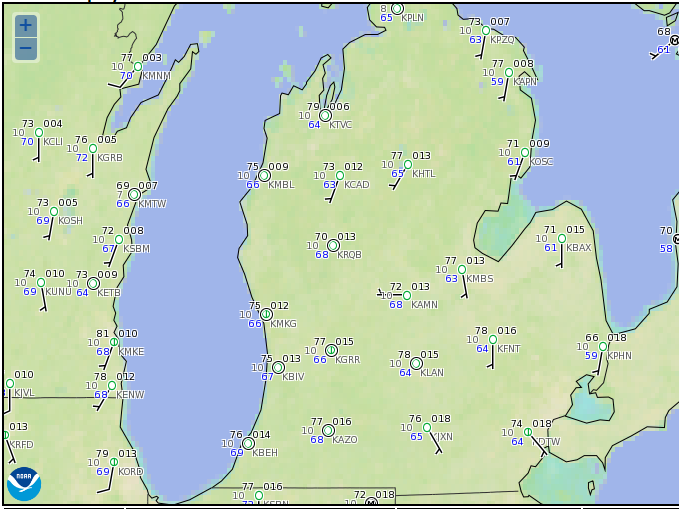
Still plenty warm with readings well into the 70's at most all the reporting stations! Lansing checking on with 78 in this image, Jackson 76. Marshall is at 75, and even though it's not here, Ann Arbor is the cool spot at 66.
HEAT ADVISORY POSTED: Every county in the blog - in the lower two thirds of the Lower Peninsula for that matter, is under a Heat Advisory for tomorrow and Friday. The text of it is available in the post prior to this one, or you can check the National Weather Service Grand Rapids Forecast Office page. In a nutshell, here's what to expect the next 48 hours
- The heat of the day will see readings into the 90's.
- Dew point values of 65 or better will be found in most places.
- The resulting Heat Index values will be near or at 100, locally higher values can't be ruled out.
I'm not going to bore you with "heat safety tips." If you're reading this, you have enough common sense to watch yourself carefully if you have to be outside, and take the necessary measures to keep cool and hydrated. I will say this though - please leave children and pets at home the next couple of days! If you must take them with you while you're out running errands, DO NOT leave them in the car when you park! Bring them inside with you. If you leave your car and forget about the two or four legged small people, it will not take long for a tragedy to happen. Even leaving the windows down a good ways may not be enough in this heat! Soapbox put away.
WHAT'S CAUSING ALL THIS?: It's what forecasters and meteorologists refer to as a "death ridge". It's a dome of hot air that is caused by a strong upper level high that is being fed by southerly flow, Air tends to sink in high pressure systems, and it will warm as it does. This is called subsidence. The reason we call this a "death ridge" is that it is not moving very much at all. The upper air pattern is blocked, so the ridge stays in the same general part of the country. It expands and shrinks and may re-distribute by shifting around by couple of states, but that's it! Here's the upper air map so you can see what I'm talking about:

I have drawn the ridge and labeled a couple of things. The numbers are the approximate height in meters of the 500 millibar pressure readings. We're pushing 6000 meters! When you see anything over 588 on a map in the summer, that's hot! Here's how hot:
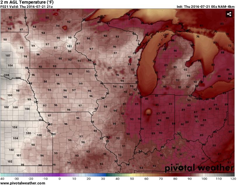
The above map is off the Hi-Res NAM Forecast Model. This is his temperature FutureCast for tomorrow at 5 PM EDT. Lower 90's across the board, more populated areas will likely be in the mid 90's thanks to the heat island effect (lots of pavement for solar radiation to heat boosts ambient temperature, also motor vehicle traffic can aid and abet heating as well). But that's only part of the story:

Here's the FutureCast for Heat Index values tomorrow at the same time. White shading is 100 degrees or better. South Central Michigan will feel like a dollar on the thermometer! Bad as that is, it's worse out west! Chicago will be pushing 110, Minnesota could make a run at 120! I think that is overdone, but not by much! This heat is serious business folks!
ANY CHANCE OF RAIN?: You'd think with all of the moisture in the air, but there's no real dynamic forcing to get anything going. That ridge is big, beefy, and stable. It'll defeat most attempts to get air rising for convection and storm development. The exception is I think we get what I call a ridge runner system coming through. That's a disturbance that's running around the edges of the ridge as it moves west to east. Normally you'd expect that to be part of a bona fide low pressure system, but in this setup, it's a disturbance that can sometimes kick off some scattered showers or a roaming thunderstorm. You can also get the occasional pulse storms that can pop up from daytime heating. From the perch here, I'm calling the mention of an isolated shower or pop-up storm in South Central Michigan tomorrow. Between say, midnight and 6 AM Friday, I think we may get a few widely scattered showers and storms. These could be strong, but spaced out some, based on a super juicy air mass.
LOOKING DOWN THE LINE: The good news is there is relief in the offing, and there is rain too! This brutally hot temperature setup should not last beyond Saturday. We'll stay warm no doubt, but forecast data is suggesting we bring daytime highs back into the mid to upper 80's for the new week, and the humidity looks to ease off some as well, because the ridge will flatten some and allow some drier air to mix into things. Tomorrow night into Friday, and then again Sunday evening look to bring rain chances up to about even money.
Here's the forecast for Jackson and vicinity:
Tonight - Mainly clear and muggy. Lows only roll back to about 68, dew point values in the 60's keep it feeling like low to mid 70's.
Thursday - Sunny and hot. Clouds start to develop late day, but not enough to mitigate heating. Heat Advisory in effect, all blog counties. High 90. Heat Index values near 100, some spots could top that figure.
Thursday Night - Clouds thicken, scattered showers and thunderstorms develop after midnight, these could be rowdy. Uncomfortable sleeping weather, with lows only rolling back to a steamy 75.
Friday - Partly cloudy, some lingering AM showers and thunderstorms. Clearing and becoming hot and sauna-like in the afternoon. High 93. Heat Index values make a run at 100 again.
Saturday - Sunshine. Still hot, but a touch less humid. High 91.
Sunday - A bit cooler still also less humid, widely scattered showers and thunderstorms possible in the afternoon. High 88.
Monday - More clouds than sunshine, still the risk of a couple of showers or a thunderstorm. High 87.
Tuesday - Sunny and warm, a bit less humid still. High 88.
There's a look at your forecast, be careful with the heat tomorrow and Friday, and have a great one! Blessings.