Monday, August 6, 2018

Stormy Monday, Better Midweek...

Good Morning!

Damp weather on the way for South Central Michigan, let's get right into what's going on!

SHOWERS & STORMS AFOOT:  Current radar from the Grand Rapids NEXRAD shows a cluster of showers and thunderstorms in Kalamazoo county, just west of the blog area, and a larger mass of showers stretching all the way up from Benton Harbor to just north of Big Rapids.  In addition, some showers and storms are starting to pop in the north zone of the blog, in Clinton and Shiawassee counties:


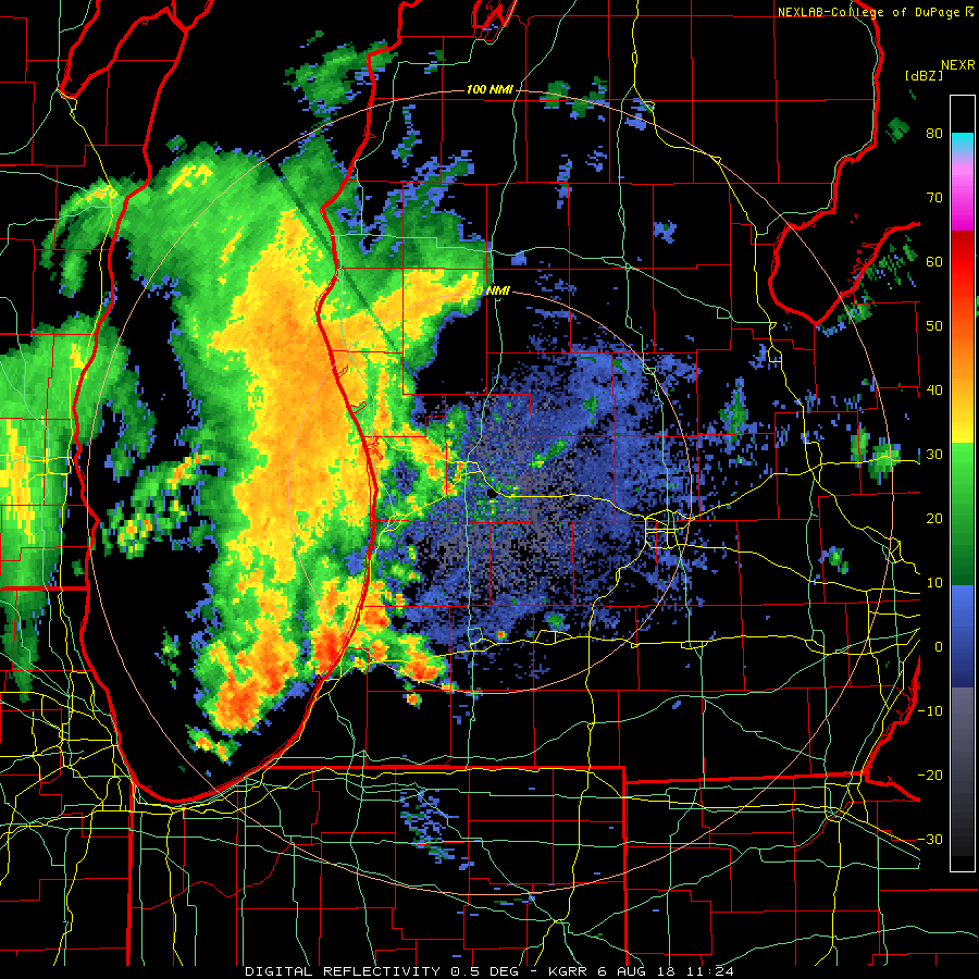
You see all of this moving east-northeast, so get the umbrellas ready.

MILD AND MUGGY FOR A BIT LONGER:  A flat ridge will keep things moist humidity-wise through late Tuesday, then we should gradually see some easing of the dewpoint values back into the 60's from the 70+ values we have in the area right now.  This means that you'll feel a little cooler and it will be a bit harder for showers and thunderstorms to get rolling in the area.  The good news is we don't have upper 80's and 90's to add to the mix, as winds are staying primarily west-northwest, and no big heat domes out west expanding into the area right now!

WHAT ABOUT RAIN:  Well, today we could see some strong or severe showers and storms with gusty wind and strong hail.  Here's the SPC graphic to show that:


One other "slight" risk, over the Front Range and eastern third of Colorado into Kansas.  I'm not expecting anything beyond the above for severe weather today.  We'll continue to keep some shower and storm risk in the forecast until at least mid week.  After that, clearing skies and seasonable for the second half of the week.

Here's the forecast:

Today - Mainly cloudy, showers and thunderstorms as the day progresses, some could be gusty with heavy rains and possibly some small hail.  High 84.

Tonight - Continued mainly cloudy, some showers and storms possible.  Lows near 68.

Tuesday - Overcast skies with periods of showers and thunderstorms.  High 85.

Wednesday - Slowly clearing skies, we can't rule out a lingering shower or PM storm.  High 83.

Thursday - Periods of clouds and sunshine, some spots could see a stray PM shower or lonely thunderstorm.  High 83.

Friday - Periods of clouds and sunshine, an isolated shower or two possible later in the day.  High 83.

There's your forecast to get you the end of the work week, have a great Monday!


Friday, August 3, 2018

Back Posting - Warm Weekend On The Way

Good Morning!

Has it really been THREE MONTHS since I last posted on this blog!?  That is just insane!  A decision is forthcoming regarding keeping this blog open, or just moving everything over to Facebook.  I personally prefer the flexibility of being able to post without being reliant on Facebook for everything, but we'll have to see what makes sense.  I have changed jobs so things should be a little less hectic regarding how I actually earn my living as opposed to this, which, for the time being is just a hobby.  Enough sidebar, let's get to some weather!

LOOKING QUIET THIS WEEKEND:  Aside from a lonely shower or two east of the blog into Detroit, not a whole lot to see.  Certainly nothing like the brief EF-0 tornado touching down in Taylor a little bit before 1 AM the other night.  I expect that we'll see more clouds than sunshine today and into the weekend, so we can't rule out a pop-up PM shower or lonely thunderstorm as a result.  The good news is that the really hot temperatures should stay away.  The clouds are also keeping us from surging into the 90's.  I expect daytime highs around 84.

HEAT IS ON FOR THE WEEKEND:  The hot air does elbow it's way back in as the upper ridge rebuilds itself.  Expect your weekend highs to climb to between 88 to 93 depending on how close you are to the southern border of Michigan.  Just the mention of an isolated raindrop or two Saturday but that is about it.

DAMP MONDAY:  The next credible chance of any widespread rain appears to be Monday, as the upper ridge positions itself more southwest of us, we'll see a couple of disturbances slide through the area, each bringing some scattered showers and a couple of thunderstorms to the party.  We'll alos cool it back down to the lower 80's as well.

Here's the forecast:

Today - Periods of clouds and sun, don't be shocked by an isolated or scattered shower or storm in the PM.  High 84.

Tonight - Some clouds persist, lows near 64.

Saturday - Sunshine increasing, and so do temperatures.  High 89.

Sunday - Mainly sunny with some passing clouds in the PM, warmer still.  High 90.

Monday - Increasing clouds, scattered showers and thunderstorms developing, cooler.  High 84.

We'll have a more detailed forecast for you later.  Have a good day!

Wednesday, May 2, 2018

Springy And Wet....

Good Morning!

Burning the late night oil for a potentially busy day weather wise in Michigan after going through the first seasonably warm taste of Spring/ (maybe even summer) in the area yesterday, with highs in the upper 70's and low 80's throughout the blog area with plenty of sunshine!  Changes are coming early tomorrow, and a chance of severe weather is in the mix as well.  Let's pop the hood and see what's running under there...

MARGINAL RISK FOR SEVERE:  Right off, I need to tell you that the Storm Prediction Center has placed most of the southern half of lower Michigan in a "Marginal" risk for severe weather tomorrow.  The good news is that I don't expect any tornadic weather out of this.


Taking a look at the SPC Outlook (this is Day 2, it will update at 8 AM), you see the southern half of Lower Michigan, excluding the thumb, in the Marginal.  Better chances for severe are just across the lake stretching from Chicago, back to places like Kansas City, Wichita, Oklahoma City, and down into Texas and points further southwest.

MORE SEVERE DETAIL:  Forecast data shows an upper disturbance working though the northern half of the Lower Peninsula this morning, and consistent with that, any rain and such appears to be confined to areas north of a line from say, Muskegon to Saginaw, so your AM and PM drives should be OK.  After dinner around the late news is the time to be concerned with.  Let's look at another graphic...


Here's a look at the hi-res NAM forecast model.  You can see that at 11 PM tomorrow, just a few thunderstorms between I-94 and I-96, and Detroit having a bit better concentration of them.  The better chance for showers and storms will be just into the northern half of the Lower Peninsula, with a second shot of showers and storms working more into South Central Michigan pre-dawn Thursday.  I still don't think we see anything tornadic, but we'll have to check the data as the day progresses.

PRECIPITATION AMOUNTS:  The second hit of showers and storms will bring the more robust precipitation amounts into South Central Michigan.  When we take a look at the precipitation map, we see...


The rain forecast thru Saturday, or Cinco De Mayo, is about 1.5", some spots will be locally higher or lower depending on storm track. Again, we'll need to look at the data and satellite and such tomorrow to get a better idea of how things will play out.

Here's the forecast:

Today - Early sun gives way to mainly cloudy skies, a pop-up shower or storm can't be ruled out.  High 82.

Tonight - Cloudy, developing showers and thunderstorms late, some could be strong or severe.  Lows near 60.

Thursday - Cloudy, scattered to numerous showers and thunderstorms, a bit cooler, with the high near 78.

Friday - Continued cloudy with scattered showers and perhaps a lingering storm or two.  High 76.

Saturday - Clearing skies with some PM sunshine and seasonable.  High 76.

Sunday - Cloudy skies, periods of showers and perhaps a thunderstorm in spots.  High only 64.

Monday - Sunny and seasonable.  High 67.

I hope that you have a great Hump Day!

Thursday, April 12, 2018

Changes Coming For The Weekend!

Good Morning!

Some shower activity in the area right now, with clouds in a good portion of South Central Michigan.  We'll see some big changes coming int he next couple of days, so let's dive in and see what we have going!

MILD AND A SHOWER:  Currently in the area we have plenty of clouds, with some showers in the far south zone, Hillsdale and Coldwater for example.  Temperatures in the mid and upper 40's, with Jackson checking on at 47 and Lansing 48.  Other than that all of the precipitation is inthe northern half of the Lower Peninsula.

FAIRLY QUIET TODAY:  Even with the clouds and such around, I don't expect much more in the way of precipitation or anything like that today, perhaps an isolated to widely scattered shower later this evening, but that's about it.  Temperatures should top out in the mid to upper 60's.  Some spots will see a 70 or two.  Mild and spring-like for sure.

NEXT WEATHER MAKER:  Our next system will start working in tomorrow afternoon and evening, and Saturday we'll wake up to cooler conditions, with showers and possibly a couple of thunderstorms during the overnight hours into Saturday.  I don't anticipate any of this activity being severe, but we will see temperatures dropping as a result back into the 60's and lower as we work through the weekend.

Here's the forecast:

Today - Cloudy and mild, we can't rule out an isolated PM shower.  High 68.

Tonight - Continued overcast, still above average temperatures that only roll back to 48.

Friday - Cloudy, scattered PM showers and perhaps a storm developing.  High 67.

Saturday - Overcast and damp - scattered to numerous showers.  Cooler.  High only 57.

Sunday - Clouds and rainy - cooler still.  High only 46.

We'll work on getting you an extended forecast up later on.  Have a great day!


Wednesday, April 11, 2018

Quick Hump Day Review...

Good Morning!

With a few minutes to spare before the day job starts, let's tap into the weather plan for the next few days...

DAMP TONIGHT - We'll see clouds thickening as the day progresses, with the approach from the west of an upper disturbance that will bring showers and perhaps an embedded thunderstorm or two.  Daytime highs today should be about 56, and the rains will move in anytime after 9 PM.  The good news is that they don't stay around too long, and while you may still have some rain to deal with for AM drive tomorrow, I don't expect anything really crazy.

PERHAPS A BIT MORE FRIDAY -  Forecast data is suggesting that we may get visited by a second round of  precipitation for Friday.  This appears to be more widely spaced shower activity, though I can't rule out a possible hit and run thunderstorm as well.  We'll see highs drop after this wave of precipitation as we are...

COOLING DOWN FOR THE WEEKEND:  We'll be giving back roughly 15-20 degrees of high temperature for the weekend.  We'll be into the upper 60's for Friday, some spots could post a 70, then that's all you see of those right through the forecast window.  We'll drop back into the 40's/low 50's regime.  The only positive to this is I don't see any real risk for snow of any consequence during the period.

Here's the forecast for Jackson and surrounding areas including Rives Junction and Concord.

Today - Mainly cloudy, any peeks of sun go away by early afternoon.  High 54.

Tonight - Rain moving in, with a possible pre-dawn thunderstorm.  Lows near 46.

Thursday - Continued overcast with a stray shower possible in a spot or two.  Warmer, high 68.

Friday - Cloudy, but the warmest day of the forecast period.  Again, we cannot eliminate the mention of a couple of periods of showers.  High 71.

Saturday - Cloudy and sharply cooler, scattered to numerous showers and maybe a lonely thunderstorm.  High only 54.

Sunday - Cloudy, damp, rainy.  High 51.

Monday - Still little to no sunshine, temperatures cooling further, rain or snow showers depending on your location.  High of only 44.

Tuesday - Lots of clouds, very little sun, a touch warmer.  High 52.

I hope that you have a great Wednesday!