Saturday, June 2, 2012
Warmer And More Seasonable...
Good Morning!
Relax, I promise you that we will not stay in the deep freeze like we were yesterday. Perhaps that was Old Man Winter letting us know that he hasn't forgotten about being bottled up last winter. Whatever it was, it was gray and rainy yesterday. We won't see temperatures that low during the day anymore for awhile though, as the thermometer will be recovering nicely. Let's take a closer look with a deeper dive:
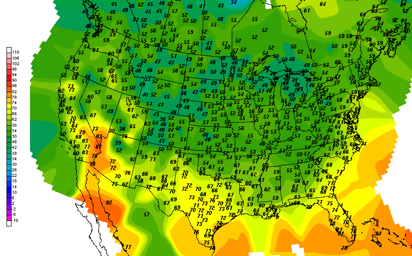
TEMPERATURES: The trough and cold front that have pushed through had the entire area with unseasonably cold conditions yesterday and last night. We struggled up to 54 degrees in Jackson, just missing my prediction by one...darn. Normal temperature yesterday was 74, so we were 20 degrees below normal. Today we will be much more seasonal, as we'll run much closer to normal not just for today, but for the next few days. Here's a look at current temperatures around the US at this hour...

RAIN: Not a whole lot of rain for the next five days, according to the National Weather Service. We come in drier than we have in previous looks at this map, with the NWS figuring on less than three-quarters of an inch of rain the next five days. Here's a look at that map, forecast is through 7AM Wednesday:

We got over a third of our entire rain amount for May yesterday, with .37 inches recorded in Jackson. Remember that we only had an inch total for the whole month.
SEVERE WEATHER: Unlike the Mid-Atlantic states yesterday that had to deal with severe thunderstorms and some tornadoes, we will have nothing like that here in Michigan for the next three days. According to the Storm Prediction Center, the only thing that we have going on today is the "general" risk for garden variety thunderstorms today. The "slight" risk is way out southwest of us in the High Plains, covering parts of CO, KS, OK, TX, and NM. Day two, just a smidge of far eastern Michigan is in a "general" zone. Here's the maps for days one and two, valid each day at 7AM.


Here's a look at the Grand Rapids NEXRAD radar, with a few very light returns up in the top of the blog zone, Clinton and Shiawassee counties.

That's drizzle or very light rain that may not even be reaching the ground up through Corunna and St. John's. And on the visible satellite, some mid level overcast in the area.

Here's the local forecast for Jackson and surrounding communities including Parma and Grass Lake:
For today, mainly cloudy skies with a few peeks of sunshine, perhaps the chance of an isolated shower or even a roaming thunderstorm in the afternoon, high 68, winds SW 7-14 MPH.
Tonight, continued partly cloudy with perhaps a few stars, a stray shower can't be ruled out, lows drop to 51, winds WNW 8-13 MPH.
Tomorrow, clearing skies, seasonable, warmer, high 75, winds WNW 10-15 MPH.
Saturday night, clearing continues slowly, lows down to 52, winds N 5-10 MPH.
Sunday, a mix of clouds and sunshine, chance of an isolated shower, high 74.
Monday, still periods of clouds and sunshine, along with a small chance of a lonely shower, high 74.
Tuesday, mainly cloudy with a break or two for sunshine, a bit cooler with a high only 70.
Wednesday, some sunshine with clouds, high 72.
Thursday, partly sunny, high 75.
There's a look at your forecast for the next six days. I do hope that you have a wonderful weekend! Blessings.
Relax, I promise you that we will not stay in the deep freeze like we were yesterday. Perhaps that was Old Man Winter letting us know that he hasn't forgotten about being bottled up last winter. Whatever it was, it was gray and rainy yesterday. We won't see temperatures that low during the day anymore for awhile though, as the thermometer will be recovering nicely. Let's take a closer look with a deeper dive:
TEMPERATURES: The trough and cold front that have pushed through had the entire area with unseasonably cold conditions yesterday and last night. We struggled up to 54 degrees in Jackson, just missing my prediction by one...darn. Normal temperature yesterday was 74, so we were 20 degrees below normal. Today we will be much more seasonal, as we'll run much closer to normal not just for today, but for the next few days. Here's a look at current temperatures around the US at this hour...
RAIN: Not a whole lot of rain for the next five days, according to the National Weather Service. We come in drier than we have in previous looks at this map, with the NWS figuring on less than three-quarters of an inch of rain the next five days. Here's a look at that map, forecast is through 7AM Wednesday:

We got over a third of our entire rain amount for May yesterday, with .37 inches recorded in Jackson. Remember that we only had an inch total for the whole month.
SEVERE WEATHER: Unlike the Mid-Atlantic states yesterday that had to deal with severe thunderstorms and some tornadoes, we will have nothing like that here in Michigan for the next three days. According to the Storm Prediction Center, the only thing that we have going on today is the "general" risk for garden variety thunderstorms today. The "slight" risk is way out southwest of us in the High Plains, covering parts of CO, KS, OK, TX, and NM. Day two, just a smidge of far eastern Michigan is in a "general" zone. Here's the maps for days one and two, valid each day at 7AM.


Here's a look at the Grand Rapids NEXRAD radar, with a few very light returns up in the top of the blog zone, Clinton and Shiawassee counties.

That's drizzle or very light rain that may not even be reaching the ground up through Corunna and St. John's. And on the visible satellite, some mid level overcast in the area.

Here's the local forecast for Jackson and surrounding communities including Parma and Grass Lake:
For today, mainly cloudy skies with a few peeks of sunshine, perhaps the chance of an isolated shower or even a roaming thunderstorm in the afternoon, high 68, winds SW 7-14 MPH.
Tonight, continued partly cloudy with perhaps a few stars, a stray shower can't be ruled out, lows drop to 51, winds WNW 8-13 MPH.
Tomorrow, clearing skies, seasonable, warmer, high 75, winds WNW 10-15 MPH.
Saturday night, clearing continues slowly, lows down to 52, winds N 5-10 MPH.
Sunday, a mix of clouds and sunshine, chance of an isolated shower, high 74.
Monday, still periods of clouds and sunshine, along with a small chance of a lonely shower, high 74.
Tuesday, mainly cloudy with a break or two for sunshine, a bit cooler with a high only 70.
Wednesday, some sunshine with clouds, high 72.
Thursday, partly sunny, high 75.
There's a look at your forecast for the next six days. I do hope that you have a wonderful weekend! Blessings.
Friday, June 1, 2012
Gray and Gloomy, It Doesn't Feel Like Summer...
Good Morning!
This forecast will be damp and dreary today. That's about it in a nutshell. Things will remain unseasonably chilly with rain. Things to start to improve some the further away we get from today. The Jackson Blues Festival out at the airport will be pretty much a washout today, though tomorrow they should see better conditions. Rain in periods all day today! Let's take a brief look:
TEMPERATURES: We don't make it out of the 50's today, with the GFS and NAM asking for 56 and 58 degree highs, respectively. Rain will make it feel even cooler than that, so I am going to low ball and say 55. After that, we moderate and warm back up to close to seasonable, as our daytime highs should be into the mid or upper 70's, and we should see a couple of 73 degree readings the next six days. Here's a look at current temperatures around the nation at around 7AM EDT...

For today to be the first day of meteorological summer, it'll feel more like early spring or late in the fall, at least today!
RAIN: Good beneficial rain to green things back up a bit will be around today and tomorrow. We were almost 2.5 inches light on precipitation last month, but we get a running start now! Here's what the National Weather Service thinks we get as far as rain totals between now and Tuesday at 7AM...

You see we should come in at over an inch -- we'll take it!
SEVERE WEATHER: Not likely. Tomorrow is the only day of the three that the Storm Prediction Center is suggesting thunderstorm development over Michigan specifically, and that extends throughout the Great Lakes into the Tennessee Valley, but that's just for garden variety storms. Best threat of severe weather today is way out east, the Mid Atlantic. Here's a look at the maps, valid at 7AM EDT each day.


Plenty of rain around right now, here's a look at the infrared satellite with the regional NEXRAD composite overlaid on it, and then a look at the Grand Rapids NEXRAD radar...


Here's the local forecast for Jackson County:
For today, GLOOMY. Cloudy, periods of showers, chilly, high 55, winds swing from NE and turn WNW 8-14 MPH.
Tonight, cloudy, rain showers start to taper off, chilly. Lows all the way down to 44 with W winds 10-15 MPH.
Tomorrow, mainly cloudy, chance of a widely scattered shower or thunderstorm, high 68, west winds 10-15 MPH.
Tomorrow night, still some lingering clouds, and still the chance of an isolated or widely scattered shower, low of 51, winds W 7-13 MPH.
Sunday, periods of clouds and sunshine, warmer, high 73.
Monday, cloudy skies, scattered showers and thunderstorms likely, high 73.
Tuesday, continued cloudy, still a chance of scattered showers and thunderstorms, high 72.
Wednesday, a mix of clouds and sun, a chance of a widely scattered shower or roaming thunderstorm, high 73.
There's a look at your forecast for the next six days, I do hope that you have a good Friday! Blessings!
This forecast will be damp and dreary today. That's about it in a nutshell. Things will remain unseasonably chilly with rain. Things to start to improve some the further away we get from today. The Jackson Blues Festival out at the airport will be pretty much a washout today, though tomorrow they should see better conditions. Rain in periods all day today! Let's take a brief look:
TEMPERATURES: We don't make it out of the 50's today, with the GFS and NAM asking for 56 and 58 degree highs, respectively. Rain will make it feel even cooler than that, so I am going to low ball and say 55. After that, we moderate and warm back up to close to seasonable, as our daytime highs should be into the mid or upper 70's, and we should see a couple of 73 degree readings the next six days. Here's a look at current temperatures around the nation at around 7AM EDT...

For today to be the first day of meteorological summer, it'll feel more like early spring or late in the fall, at least today!
RAIN: Good beneficial rain to green things back up a bit will be around today and tomorrow. We were almost 2.5 inches light on precipitation last month, but we get a running start now! Here's what the National Weather Service thinks we get as far as rain totals between now and Tuesday at 7AM...

You see we should come in at over an inch -- we'll take it!
SEVERE WEATHER: Not likely. Tomorrow is the only day of the three that the Storm Prediction Center is suggesting thunderstorm development over Michigan specifically, and that extends throughout the Great Lakes into the Tennessee Valley, but that's just for garden variety storms. Best threat of severe weather today is way out east, the Mid Atlantic. Here's a look at the maps, valid at 7AM EDT each day.

Day 1

Day 2
Plenty of rain around right now, here's a look at the infrared satellite with the regional NEXRAD composite overlaid on it, and then a look at the Grand Rapids NEXRAD radar...

Infrared Satellite with Regional NEXRAD Composite Data

Grand Rapids NEXRAD Radar Reflectivity
For today, GLOOMY. Cloudy, periods of showers, chilly, high 55, winds swing from NE and turn WNW 8-14 MPH.
Tonight, cloudy, rain showers start to taper off, chilly. Lows all the way down to 44 with W winds 10-15 MPH.
Tomorrow, mainly cloudy, chance of a widely scattered shower or thunderstorm, high 68, west winds 10-15 MPH.
Tomorrow night, still some lingering clouds, and still the chance of an isolated or widely scattered shower, low of 51, winds W 7-13 MPH.
Sunday, periods of clouds and sunshine, warmer, high 73.
Monday, cloudy skies, scattered showers and thunderstorms likely, high 73.
Tuesday, continued cloudy, still a chance of scattered showers and thunderstorms, high 72.
Wednesday, a mix of clouds and sun, a chance of a widely scattered shower or roaming thunderstorm, high 73.
There's a look at your forecast for the next six days, I do hope that you have a good Friday! Blessings!
Thursday, May 31, 2012
Chilly and Damp...Then Slowly Improving...
Good Morning!
A cool start to the day today, with temperatures here in the mid 40's. That's still not as cool as it was in the northern half of the mitten last night, where there were frost and freeze advisories! That's not something that you hear of toward the end of May normally! Let's take a deeper dive and see what's on tap for the next few days...
TEMPERATURES: We'll see some of the coldest temperatures that we have seen here in south central Michigan in quite awhile today and tomorrow, as I am not expecting us to even break 60 tomorrow, and if we do, it'll be with a 61. The GFS and NAM computer models are suggesting 59 and 56 for daytime highs tomorrow! After we get through Friday, temperatures start to make a slow climb back to seasonal levels, with mid 70's expected for back to work next week. Just take a look at the surface temperature readings around the US this hour...

RAIN: We definitely could use some around here, and it looks like the rain gauge will get a flying start tomorrow, with rain pretty much all day. That still won't offset the 2.5 inches we are short this month so far, but it sure will help, as the lawns are starting to look parched, even with regular sprinkling. I expect shower activity to start in earnest this afternoon, after a few sprinkles here and there throughout the area. Here's a look at what the National Weather Service thinks we'll get as far as rain for the next five days...

We are expected to pick up just over an inch, and we'll likely get the lion's share of that in the next 24 to 48 hours.
SEVERE WEATHER: Nothing here in Michigan for the next three days, but off to the south of us in the lower Ohio Valley and working back toward Texas, there's a chance at some severe weather today, and then the threat moves off to the east, over Georgia, the Carolinas, the Virginias, and up to Pennsylvania. It will be too cool for any severe weather up here for the next day or two. This map from the Storm Prediction Center shows the wind probability associated with severe storms, meaning gusty thunderstorms with some hail are the primary threats for the areas affected...

Plenty of clouds in the satellite image, with the more organized rain producing clouds, back toward the lake, and into Chicago and points southwest. Below that, the Grand Rapids NEXRAD radar shows showers out over Lake Michigan drifting this way, even though they are dying off as they move east right now, that's the post-lunchtime rain I allude to in the forecast.


Here's a look at the local forecast for Jackson County:
Today mainly cloudy skies, a chance of showers after lunchtime, continued cool with a high of 62. Winds N 7-14 MPH.
Tonight cloudy skies, not quite as cold, scattered showers expected by daybreak, low 47, northerly winds calm to 5 MPH.
Friday, cloudy skies, showers are likely, unseasonably cool with a high of 58. Winds NW 8-15 MPH, gusting to 20 MPH.
Friday night, rain tapers off late, leaving mainly cloudy skies with some breaks for stars, low 44. Winds becoming W 7-14 MPH.
Saturday, some clearing, perhaps a chance of an isolated lingering shower, warmer, high near 70.
Sunday, more clouds than sunshine, chance of a few scattered showers, warmer, high of 73.
Monday, skies become mostly cloudy with a chance of showers, high 75.
Tuesday, a mix of clouds and sun, seasonable and nice, high 78.
There's a look at your forecast for the next six days, have a great Thursday. Blessings!
Wednesday, May 30, 2012
Summer? Not According To The Thermometer...
Good Morning!


The cooler weather has settled into the area, and it will remain with us for the next few days. In fact, we may not see 70 again until Saturday, if everything plays out as advertised by the computer modeling. Let's take a deeper dive and see what's going on.
TEMPERATURES: Now that the short wave trough and cold front have pushed through the area, northwesterly flow from Canada is in place, leading up to a cool start for meteorological summer, which is June 1st. The warmest temperature in the computer modeling is 76 on Monday, with increasing clouds along the way. Below normal for sure. And if you can believe it, the NAM and GFS computer models are calling for 58 and 59 for highs on Friday!
RAIN: As it stands now, from Thursday night on is our best chance for rain, and it looks like Friday may be pretty much a washout. The National Wather Service thinks that we should pick up about three-quarters of an inch of rain in the next five days, through 7AM Sunday. Here's a look at that map for you...

Right around Oklahoma and Arkansas, they are expected to get almost four inches the next five days. We could use some of that up here, for sure. Normally we get around three inches of rain in Jackson during May. So far we only have .60, or a little better than a half-inch of rain for the month. A good soaking rain would be very beneficial.
SEVERE WEATHER: Nothing here in Michigan for the next three days, but look out now, a "moderate" risk bullseye over most fo Oklahoma and extreme north-central Texas today. That "moderate" risk includes a 10% chance for tornadoes and an almost 50-50 shot at hail producing storms. Here's the map for today.

And here's the map for tomorrow, showing the risk area sliding east. Dixie Alley may get some action, even though they could do without it, aside from rain, as they are dry there as well. That area covers a a lot of ground, starting in Texas, moving northeast through the deep south and up into the lower Ohio Valley.

Grand Rapids NEXRAD radar is all quiet, with nothing aside from the ever-present ground clutter at this hour, and the visible satellite has just some mid-level clouds on it north of us.
Here's the local forecast for Jackson and surrounding communities including Tompkins and Cement City:
Today, plenty of sunshine, much cooler, high only 70, winds NW 7-14 MPH.
Tonight, mostly starry skies with passing clouds, chilly, with nighttime lows all the way down to 41, winds northerly 5-10 MPH.
Thursday starts clear, then clouds slowly start increasing during the afternoon, continued cool with a high of 62. Winds N 3-8 MPH.
Thursday night cloudy skies, not quite as cold, scattered showers expected by daybreak, low 44, winds N calm to 5 MPH.
Friday, cloudy skies, showers and thunderstorms likely, unseasonably cool with a high of 58.
Saturday, cloudy skies, cooler, scattered showers and perhaps an isolated thunderstorm are likely, high near 70.
Sunday, more clouds than sunshine, chance of a few scattered showers, warmer, high of 73.
Monday, sunny skies, seasonable, high 76.
There's a look at your forecast for the next six days, I do hope you have a great hump day Wednesday! Blessings!
Tuesday, May 29, 2012
Did I Hear Records Falling?
Good Morning!
Just got the chance to pore over some data, and yes, records did fall: I do not as of yet have the prior record, if I find those I will edit this post accordingly:
Sunday May 27th Records:
Hillsdale - 92
Coldwater - 93
Adrian - 95
Ann Arbor - 82
Monday May 28th Records:
Hillsdale - 92
Adrian - 90
Ann Arbor - 93
Cooler weather on the way though!
It Runs Hot Then Cold Here....
Good Morning!
Cooler weather is on the way. After heat index values in the mid to upper 90's the last couple of days, and showers and storms that largely missed us but just clipped the northwest and southeast area of the blog, we get high temperatures that are a lot closer to normal today, and then run below normal for the rest of the week. One deeper dive coming up...
TEMPERATURES: A pretty steep drop in temperature is on the way...After seeing highs around the 90 mark, we roll back to the lower 80's today, then we don't see anything above 70 again until the end of the week. It will be a cool start to meteorological summer! A trough, then a cold front will move through the area, bringing air that is more reminiscent of a stable mid-spring pattern. Low dew points and humidity values, highs in the 60's during the day and lows in the 40's at night.
RAIN: Not much rain on tap for the next five days in the area, not at least until we get to Friday. That will be our next good shot at getting some rain in this neck of the woods. The National Weather Service is thinking that we will pick up around an inch the next five days. Here's a look at that map, good through Saturday morning at 7AM.

We could use some rain too. Average rain for May in Jackson is right at about 3 inches according to the NWS, and so far this month we've recorded just .60 inch of rain, so things are getting pretty dry.
SEVERE WEATHER: As we are now on the back side of the trough, and there is the approaching cold front, with drier more stable air, the severe threat has moved on to the southeast of us. Severe storms fired northwest of us last night, getting into the far northwest and southeast parts of the blog area, but that's it. Nothing for Michigan outside a general chance of garden variety storms for Ann Arbor and points east. After that, not much for the next few days. I will show you the Day 1 and Day 2 maps from the Storm Prediction Center though...look at that "moderate" risk bullseye at the south end of Tornado Alley tomorrow! These are valid at 7AM EDT as always...


I'm sure the storm chasers will be licking their chops at that potential chance for action in Oklahoma and Kansas.
All quiet in West Michigan, so we'll take a look at some strong thunderstorms moving out of Lenawee County right now on the Detroit NEXRAD radar, they'll move pretty quick and be in Monroe County and over into Canada before too long.

And this is the visible satellite image:

You can see the clearing behind the cold front (northwest part of the Lower Peninsula where there are no clouds showing).
Here's a look at the forecast for Jackson and surrounding communities including Michigan Center and Hanover-Horton...
For today, a mix of clouds and sunshine, breezy, not as warm, a chance of an isolated or widely scattered shower until around dinnertime, high 80, winds turning NW 7-15 MPH.
Tonight, mostly clear skies, a few passing clouds, much cooler and drier, lows roll all the way back to 50, winds W 3-7 MPH.
Tomorrow, another mixed bag of clouds and sunshine, much cooler, high only 67, winds NW 7-14 MPH.
Wednesday night, mostly starry skies, perhaps a passing cloud or two, chilly, nighttime lows all the way down to 41, winds northerly 5-10 MPH.
Thursday, clear to start then clouds slowly start building in after lunchtime, continued cool with a high of 66.
Friday, mainly cloudy skies, scattered showers and thunderstorms likely in the evening, a touch warmer with a high of 71.
Saturday, cloudy skies, cooler, scattered showers and perhaps a roaming thunderstorm are likely, high only 66.
Sunday, mainly cloudy, perhaps a peek or two of sunshine, chance of a few scattered showers, warmer, high of 73.
There's your forecast for the next six days, I do hope you have a great Tuesday! Blessings.
Cooler weather is on the way. After heat index values in the mid to upper 90's the last couple of days, and showers and storms that largely missed us but just clipped the northwest and southeast area of the blog, we get high temperatures that are a lot closer to normal today, and then run below normal for the rest of the week. One deeper dive coming up...
TEMPERATURES: A pretty steep drop in temperature is on the way...After seeing highs around the 90 mark, we roll back to the lower 80's today, then we don't see anything above 70 again until the end of the week. It will be a cool start to meteorological summer! A trough, then a cold front will move through the area, bringing air that is more reminiscent of a stable mid-spring pattern. Low dew points and humidity values, highs in the 60's during the day and lows in the 40's at night.
RAIN: Not much rain on tap for the next five days in the area, not at least until we get to Friday. That will be our next good shot at getting some rain in this neck of the woods. The National Weather Service is thinking that we will pick up around an inch the next five days. Here's a look at that map, good through Saturday morning at 7AM.

We could use some rain too. Average rain for May in Jackson is right at about 3 inches according to the NWS, and so far this month we've recorded just .60 inch of rain, so things are getting pretty dry.
SEVERE WEATHER: As we are now on the back side of the trough, and there is the approaching cold front, with drier more stable air, the severe threat has moved on to the southeast of us. Severe storms fired northwest of us last night, getting into the far northwest and southeast parts of the blog area, but that's it. Nothing for Michigan outside a general chance of garden variety storms for Ann Arbor and points east. After that, not much for the next few days. I will show you the Day 1 and Day 2 maps from the Storm Prediction Center though...look at that "moderate" risk bullseye at the south end of Tornado Alley tomorrow! These are valid at 7AM EDT as always...

Day 1

Day 2
All quiet in West Michigan, so we'll take a look at some strong thunderstorms moving out of Lenawee County right now on the Detroit NEXRAD radar, they'll move pretty quick and be in Monroe County and over into Canada before too long.

And this is the visible satellite image:

You can see the clearing behind the cold front (northwest part of the Lower Peninsula where there are no clouds showing).
Here's a look at the forecast for Jackson and surrounding communities including Michigan Center and Hanover-Horton...
For today, a mix of clouds and sunshine, breezy, not as warm, a chance of an isolated or widely scattered shower until around dinnertime, high 80, winds turning NW 7-15 MPH.
Tonight, mostly clear skies, a few passing clouds, much cooler and drier, lows roll all the way back to 50, winds W 3-7 MPH.
Tomorrow, another mixed bag of clouds and sunshine, much cooler, high only 67, winds NW 7-14 MPH.
Wednesday night, mostly starry skies, perhaps a passing cloud or two, chilly, nighttime lows all the way down to 41, winds northerly 5-10 MPH.
Thursday, clear to start then clouds slowly start building in after lunchtime, continued cool with a high of 66.
Friday, mainly cloudy skies, scattered showers and thunderstorms likely in the evening, a touch warmer with a high of 71.
Saturday, cloudy skies, cooler, scattered showers and perhaps a roaming thunderstorm are likely, high only 66.
Sunday, mainly cloudy, perhaps a peek or two of sunshine, chance of a few scattered showers, warmer, high of 73.
There's your forecast for the next six days, I do hope you have a great Tuesday! Blessings.
Significant Weather Advisory, Lenawee County
The National Weather Service in Detroit has posted a...
...SIGNIFICANT WEATHER ADVISORY...

AT 944 AM EDT...NATIONAL WEATHER SERVICE DOPPLER RADAR INDICATED
STRONG THUNDERSTORMS ALONG A LINE EXTENDING FROM CANTON TO 8 MILES
NORTHEAST OF DUNDEE TO 14 MILES WEST OF TEMPERANCE...MOVING EAST AT
45 MPH.

ONE HALF INCH DIAMETER HAIL...WINDS UP TO 40 MPH...BRIEF HEAVY
DOWNPOURS...ARE POSSIBLE WITH THESE STORMS.

* THUNDERSTORMS WILL BE NEAR...
  ROMULUS AND LAMBERTVILLE BY 955 AM EDT...
  TEMPERANCE AND TAYLOR BY 1000 AM EDT...
  FLAT ROCK AND DEARBORN BY 1005 AM EDT...
  DETROIT AND WYANDOTTE BY 1010 AM EDT...
  MONROE AND GROSSE ILE BY 1015 AM EDT...
  GROSSE POINTE BY 1025 AM EDT...
  ST. CLAIR SHORES BY 1030 AM EDT...


GUSTY WINDS MAY CAUSE SMALL OBJECTS SUCH AS TRASH BINS TO BLOW
AROUND. SEEK SHELTER IN A STURDY STRUCTURE UNTIL THESE STORMS HAVE
PASSED.
Monday, May 28, 2012
Significant Weather Advisory, Washtenaw
Good Evening
The National Weather Service has issued a...
The National Weather Service has issued a...
...SIGNIFICANT WEATHER ADVISORY FOR WASHTENAW COUNTY UNTIL 1145 PM
EDT...

AT 1054 PM EDT...NATIONAL WEATHER SERVICE DOPPLER RADAR INDICATED
THAT A THUNDERSTORM WAS RAPIDLY DEVELOPING NEAR CLINTON...OR 6 MILES
NORTH OF TECUMSEH...MOVING NORTHEAST AT 35 MPH.

HAIL UP TO ONE-HALF INCH IN DIAMETER AND WIND GUSTS UP TO 40 MPH ARE
EXPECTED WITH THIS STORM...ALONG WITH HEAVY RAIN.

THIS STORM WILL BE NEAR...
SALINE AROUND 1110 PM EDT.
PITTSFIELD TOWNSHIP AROUND 1115 PM EDT.
ANN ARBOR AROUND 1120 PM EDT.
YPSILANTI AROUND 1125 PM EDT.
DIXBORO AROUND 1130 PM EDT.
SALEM AROUND 1140 PM EDT.

THIS STORM MAY INTENSIFY...SO BE CERTAIN TO MONITOR LOCAL RADIO AND
TV STATIONS...AS WELL AS LOCAL CABLE TV OUTLETS... FOR ADDITIONAL
INFORMATION AND POSSIBLE WARNINGS FROM THE NATIONAL WEATHER SERVICE.

TORRENTIAL RAIN...WHICH MAY FLOOD LOW LYING AREAS SUCH AS DITCHES AND
UNDERPASSES...IS ALSO LIKELY. DO NOT DRIVE YOUR VEHICLE ON A FLOODED
ROADWAY.
Muggy Memorial Day, Then Cooling Off....
Good Morning!


Happy Memorial Day, and thanks to those of you that are serving, and have served, both here and abroad, alive or no longer with us. Thanks for safeguarding our freedom and this nation!
Summer is here, at least in the minds of most, with Memorial Day through Labor Day being defined as summer. And it will feel and act like it too! It will be hot and muggy, scattered showers and thunderstorms are on tap for the afternoon and evening, some of those could be severe. Let's take a look and see what's going on.
TEMPERATURES: Very warm. Jackson is already into the 70's, with Lansing almost there, and it is not even 8AM as I write this forecast! Here's a look at temperatures around the country at 8AM...You can see the big warm air ridge east, and the cold trough west. The 50's and 60's readings show you where the cold front is now that we expect to roll through here in the next day or two...

I expect the high for Jackson today to get to 92, with 91 in Lansing, but heat index values will be in the upper 90's, possibly even 100. Tomorrow, about a 10 degree drop, and after that, another 10-15 degrees falls off, with daytime highs rolling back into the mid to upper SIXTIES. Average temperatures this time of year run around 75 for this area, and all signs indicate we'll be below that, as a cold front moves through, bringing precipitation along with it. Let's look at that part.
RAIN: A much wetter look than we have seen in recent days, with Michigan looking at a range of over two and-a-half inches to about a half-inch from east to west for the next five days. Here's the forecast map from the National Weather Service, valid at 7AM today...

A cold front pushes through later today and into tomorrow, kicking off showers and storms, then we stay fairly dry until another trough drops in here on Friday, bringing us a wet weekend from the looks of things.
SEVERE WEATHER: The Storm Prediction Center has us under a "slight" risk for severe weather today. The main issues would be hail and damaging wind. After we get through today, no sever weather is expected in Michigan for the next couple of days after that. Here's the map for today from the SPC, valid at 7AM...

As you see, the other potential hot spots are in lower New England, and a chunk of north central Texas, and south central Oklahoma.
Nothing on the Grand Rapids NEXRAD radar at this hour but ground clutter, I do want you to notice the green numbers on the observations.

Those are dewpoints. All of them in the 60's and it's just now after 8AM. The only non 60 reading is way up north at the top in Alpena, with a 55, but that's also their air temperature, so the humidity is 100%! The sun is risen enough to see and use the visible satellite image, that shows some scattered clouds...

Currently Jackson is 72 with a dewpoint of 63, relative humidity a sticky 68%, winds SW at 7 MPH.
Here's the Memorial Day forecast for Jackson and surrounding communities including Concord and Pleasant Lake...
Today, mostly sunny, clouds increase as the day wears on, with a chance at scattered showers and thunderstorms, some possibly severe. Hot, humid, high 92, heat index values near 100. SW winds 7-15 MPH.
Tonight cloudy, still a chance at scattered showers and thunderstorms, some may be severe, nighttime lows roll back to 66, SW winds 5-10 MPH.
Tuesday, a mix of clouds and sunshine, cooler, chance at a widely scattered shower or two on the back side of the cold front moving through, high 81, winds SW 7-14 MPH.
Tuesday night, clear skies, much cooler, lows drop to 50, WNW winds 6-12 MPH.
Wednesday, mainly sunny with a few passing clouds, unseasonably cool, high only 66.
Thursday, sunny, continued cool, high 67.
Friday, cloudy, with a chance of scattered showers, high 68.
Saturday, continued cloudy, still a chance of scattered showers, high 67.
There's a look at your forecast for the next six days, I do hope you have a safe and enjoyable Memorial Day! Blessings.
Sunday, May 27, 2012
Some Sun, Lots of Warmth!
Good Morning!
It will be a hot day today in South Central Michigan, with a lot of areas seeing readings near 90 degrees and heat index values in the mid 90's. Strong thunderstorms are moving through the area off to our north, but we are not expected to have anything like that here - at least not until tomorrow. A surface low is moving through the area up there, and in front of it, showers and thunderstorms will be the rule. Here, just warm, with the best chance of showers and storms coming tomorrow into Tuesday.
Here's the forecast for Jackson County:
For today, mainly sunny with a few passing clouds, perhaps the chance of a widely scattered shower or two, warm, high 87. Winds ESE 5-10 MPH.
Tonight, mostly starry skies with a few clouds here and there, low 65, winds becoming southerly 5-10 MPH.
Memorial Day, very warm, some passing clouds, a chance of a shower or thunderstorm in the afternoon, high 91, Winds 7-14 MPH.
Monday night, mostly cloudy skies, scattered showers and perhaps a couple of thunderstorms, low 65, winds SW 6-12 MPH.
Tuesday, a mix of clouds and sunshine, cooler a chance of showers and thunderstorms, with a high of 82.
Wednesday, mainly cloudy skies, possibly a few breaks for sunshine, much cooler, high 66.
Thursday, clouds linger, possibly a few peeks of sunshine, a high of only 65.
Friday, cloudy, a chance of an isolated shower, high 67.
That's a brief look at your forecast for the next six days, I do hope you have a wonderful day! Blessings.
Subscribe to:
Posts (Atom)