Relax, I promise you that we will not stay in the deep freeze like we were yesterday. Perhaps that was Old Man Winter letting us know that he hasn't forgotten about being bottled up last winter. Whatever it was, it was gray and rainy yesterday. We won't see temperatures that low during the day anymore for awhile though, as the thermometer will be recovering nicely. Let's take a closer look with a deeper dive:
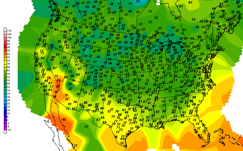
TEMPERATURES: The trough and cold front that have pushed through had the entire area with unseasonably cold conditions yesterday and last night. We struggled up to 54 degrees in Jackson, just missing my prediction by one...darn. Normal temperature yesterday was 74, so we were 20 degrees below normal. Today we will be much more seasonal, as we'll run much closer to normal not just for today, but for the next few days. Here's a look at current temperatures around the US at this hour...
RAIN: Not a whole lot of rain for the next five days, according to the National Weather Service. We come in drier than we have in previous looks at this map, with the NWS figuring on less than three-quarters of an inch of rain the next five days. Here's a look at that map, forecast is through 7AM Wednesday:

We got over a third of our entire rain amount for May yesterday, with .37 inches recorded in Jackson. Remember that we only had an inch total for the whole month.
SEVERE WEATHER: Unlike the Mid-Atlantic states yesterday that had to deal with severe thunderstorms and some tornadoes, we will have nothing like that here in Michigan for the next three days. According to the Storm Prediction Center, the only thing that we have going on today is the "general" risk for garden variety thunderstorms today. The "slight" risk is way out southwest of us in the High Plains, covering parts of CO, KS, OK, TX, and NM. Day two, just a smidge of far eastern Michigan is in a "general" zone. Here's the maps for days one and two, valid each day at 7AM.


Here's a look at the Grand Rapids NEXRAD radar, with a few very light returns up in the top of the blog zone, Clinton and Shiawassee counties.

That's drizzle or very light rain that may not even be reaching the ground up through Corunna and St. John's. And on the visible satellite, some mid level overcast in the area.

Here's the local forecast for Jackson and surrounding communities including Parma and Grass Lake:
For today, mainly cloudy skies with a few peeks of sunshine, perhaps the chance of an isolated shower or even a roaming thunderstorm in the afternoon, high 68, winds SW 7-14 MPH.
Tonight, continued partly cloudy with perhaps a few stars, a stray shower can't be ruled out, lows drop to 51, winds WNW 8-13 MPH.
Tomorrow, clearing skies, seasonable, warmer, high 75, winds WNW 10-15 MPH.
Saturday night, clearing continues slowly, lows down to 52, winds N 5-10 MPH.
Sunday, a mix of clouds and sunshine, chance of an isolated shower, high 74.
Monday, still periods of clouds and sunshine, along with a small chance of a lonely shower, high 74.
Tuesday, mainly cloudy with a break or two for sunshine, a bit cooler with a high only 70.
Wednesday, some sunshine with clouds, high 72.
Thursday, partly sunny, high 75.
There's a look at your forecast for the next six days. I do hope that you have a wonderful weekend! Blessings.
No comments:
Post a Comment