Saturday, June 21, 2014

Six Day Planner...

Good Afternoon:

I think the title is pretty self explanatory - Sunday looks nice, then as temperatures and humidity climb, expect some periods of showers and thunderstorms Monday and into Tuesday.


Have a great afternoon!

Summer Sails In...

Good Morning!

Let's get right to it.

SUMMER, SUMMER, SUMMER, SUMMERTIME:  The Summer Solstice occurred at 6:51 AM today, meaning season-wise, we kick off the second half, with today being the first day of Summer.  Get out and enjoy, clouds have moved off and we'll dry out.  The Summer Solstice also means that it's all downhill from here - the days start to gradually shorten from here on out.

FAIRLY STABLE WEATHER PATTERN:  Not much change in the upper air dynamics expected the next several days, so we'll keep seeing a couple of days of clear, quiet weather, interspersed with some periods of showers and a few storms.  The upper air systems are basically locked into place, which means that disturbances and bona fide systems are confined to the same parts of the US.  Look at this chart:

500 MB (18,000 ft) Upper Air Chart - The heat dome is parked off Southern California, waiting to come ashore.  Westerly winds prevail, ridging is somewhat damped out.  Bona Fides 1 and 2 won't break camp until next week.  Some disturbances are able to filter through the middle third of the US, and daytime heating also has the greatest impact in that same area - bringing the best chance for PM showers/storms.
Two big beefy lows, one up by Alaska, the other off the Newfoundland coast, and a smaller, weaker one in central Canada all conspire to keep us fairly zonal in flow.  That means no truly brutal summer heat in the cards just yet, though we will see warmer, more humid conditions into next week.

DRY WEEKEND, WET START TO THE WEEK:  While I certainly can't say the chances of a PM shower are non-zero, they surely are the lowest they have been in quite sometime.  The weekend will have some mixed sunshine and seasonable readings, with an 81 on deck for Sunday.  Monday feels more like summer, as warmer, more humid air pushes in from the south.  I expect scattered showers and thunderstorms in the area Monday afternoon and evening, and those stay around in fits and starts through at least Wednesday.  Let's see what the Weather Prediction Center thinks about rains:


A fairly wet look for Michigan and the eastern two-thirds of the US according to the forecast map.  This suggests rainfall totals of up to an inch and a half between now and 8 AM Thursday, with higher totals locally to the southwest of us.

SEVERE WEATHER?:  I don't really think so.  Maybe some localized heavy rain and perhaps marginally gusty wind, but nothing to be overly concerned with.  The Storm Prediction Center does think that perhaps the far southwest tip of lower Michigan has a crack at severe weather today.  Places like Benton Harbor and Bridgman for example.

Here's what's anticipated down the line and a look at the forecast for the weekend...


Forecast:


I'll get the six day planner hashed out and posted for you later.  Have a great first day of summer!  Blessings.

Thursday, June 19, 2014

A Bit Quieter For Awhile...

Good Morning!

After a couple of days with severe weather in the mix, a more benign look to the weather pattern in the area, though we do keep raindrops in the picture until early next week.  Let's take a look:

QUIETER AND CLOUDY, THANK YOU:  No formal severe weather risk on tap today according to the Storm Prediction Center, as the better dynamics and ingredients for big time storms are still nestled in the Plains, with Iowa and Kansas having the best look for severe activity later.  Here's the SPC risk map:


Even with no formal risk, we could still see a lonely afternoon storm in this part of the world today.  A brief downpour and perhaps some wind gusts would be the primary issues.  We don't fully get rid of the clouds for awhile yet, but we do get a quick breather from the rain and storms for the most part.

DAMP FRIDAY CLOSES THE WORK WEEK:  Forecast data is suggesting clouds with a ragged line of showers and a few storms moving through late morning or lunchtime Friday.  That line looks to cover most of the Lower Peninsula as it moves through.  Here's the NAM model futurecast for tomorrow at 11 AM EDT:

As always, the disclaimer applies - ONE forecast model - ONE solution.  With that in mind, the data all seem to agree on a line of showers working though the area tomorrow, with varying ideas on time, so we definitely mention some scattered showers and possibly a thunderstorm.  I think the NAM provides the most balanced look of the models I checked today, so that's why I'm going with this futurecast.  Beyond that, some sun and drier for the weekend.  Make sure you have the insect repellent, as the rains this week will spawn a fresh crop of bugs!

A WET START TO THE NEW WEEK:  After a respite from the rain Saturday and Sunday, Monday brings clouds again and the shower gets turned back on.  That in turn, causes me to say what you hear so much from forecasters and meteorologists this time of year: periods of scattered afternoon showers and thunderstorms.  We keep those on the table through Tuesday evening, then high pressure works into the area, clearing the skies and drying us out.  That dryness stays with us until Sunday, when the next weather maker finishes shoving the high off to the east, and skies again cloud up.

REASONABLE TEMPERATURES, IF A BIT COOL:  The next several days in the area will see readings right around normal, which is about 82.  We'll be a bit cooler than that today and tomorrow, with readings hovering near 78.  I say a bit cool because looking down the line, computers are suggesting highs that don't make 75 after the rain and such next week!

Here's the forecast for Jackson and surrounding areas including Parma and Grass Lake:


And here's the extended outlook:


That's how things look to unfold in the coming days.  I hope this day is a great one for you!  Blessings.

Wednesday, June 18, 2014

SEVERE THUNDERSTORM WATCH CANCELED

The Severe Thunderstorm Watch has been canceled for the blog.  That being said, more showers and storms will visit later, they too will bring heavy rain and gusty wind.

Severe Thunderstorm Watch - Entire Blog

SEVERE THUNDERSTORM WATCH 321 IS IN EFFECT UNTIL 900 PM EDT
FOR THE FOLLOWING LOCATIONS
MI
.    MICHIGAN COUNTIES INCLUDED ARE
BARRY                BRANCH              CALHOUN
CASS                 CLINTON             EATON
GENESEE              HILLSDALE           INGHAM
JACKSON              KALAMAZOO           LAPEER
LENAWEE              LIVINGSTON          MACOMB
MONROE               OAKLAND             SHIAWASSEE
ST. CLAIR            ST. JOSEPH          WASHTENAW
WAYNE

FutureCast For Today...

Hello!

Clearing skies for the moment in the area will allow the sun to warm the ground and destabilize the atmosphere.  In other words the battery is being charged for a show this afternoon and tonight.  Have a look at these two graphics:


Disclaimer:  ONE MODEL, ONE SOLUTION.  That being said, the HRRR has been not too shabby of late, so I'll buy what he's seeing regarding how things play out later.  These are futurecast images of what the HRRR computer model thinks the radar will look like at 3 and 8 PM today.  Basically it stacks up to scattered showers and thunder this afternoon, then a break until about 8.  I'll have updates as needed. 


Cloudy, Sticky, Stormy...

Good Morning!

ANOTHER DAY OF SEVERE WEATHER RISK:  The Storm Prediction Center has us in the standard "slight" risk category for severe thunderstorms today and tonight.  Have a look at the forecast map:


There are strong storms going on to the north and west of the blog area at this hour.  Here's a look at Tru-Track Doppler radar...

Here you see the storms in the state.  They are moving due east, and have history of strong wind and up to ping-pong ball sized hail.  The wild card today will be the amount of sun we see.  The conditions are more or less in place for strong to severe storms with straight-line wind and hail as the primary threats.  Less sun means less robust storms.  While I can't say the tornado risk is truly zero, I can say that I do not see much in the way of shear to spin the storms we do get and coax them into producing tornadoes right now.  That setup is found across the lake in Wisconsin.

STILL SULTRY AND STICKY:  It will be another muggy one in South Central Michigan today as dewpoint values again are already into the 60's, and in some cases, even 70.  Sturgis is reporting a dewpoint of 72 at this hour!  The good news is that the temperatures shouldn't approach the 90 that I posted in the Six Day Planner previously, as cooler air has filtered into the region.  That and cloud cover will help keep readings down.  We'll keep this moist air around right through the weekend, but I do expect it to become less damp as Friday and Saturday roll in.

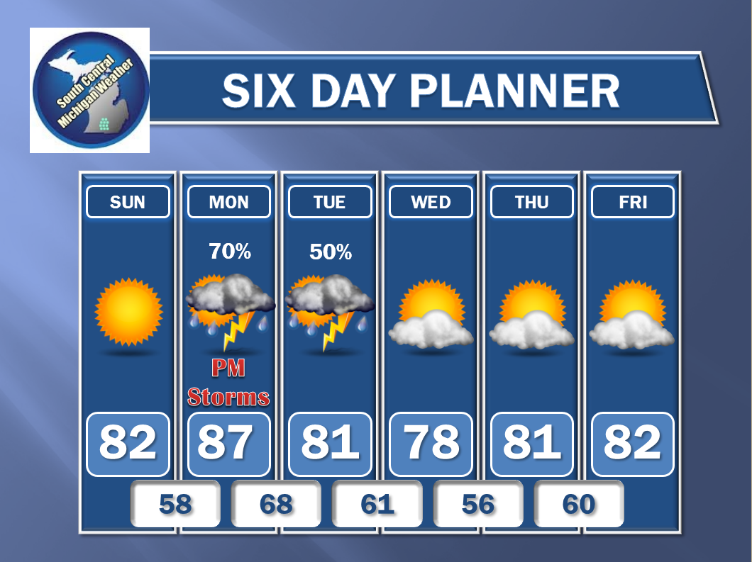
CHANCES OF RAIN INTO NEXT WEEK:  Looking at forecast model data this morning I'm seeing the typical summer weather pattern shaping up.  Scattered showers with the occasional thunderstorm for variety right into Monday.  That doesn't mean that any day will be a washout (it shouldn't be), but it does mean that tossing an umbrella in the car is a smart call.  The bright blue skies that we enjoyed over race weekend will likely not be back before then.

MORE SEASONABLE TEMPERATURES:  Looking down the line, temperatures come down, back to seasonal levels.  Most places in the blog should be about 80-82 this time of year, and I expect things to run right around there.

Here's the forecast for Jackson and surrounding areas including Concord and Rives Junction:

Today - Mainly cloudy, some scattered showers and thunderstorms, especially this afternoon, some could be severe.  High 83.  Wind ESE 6-12 MPH.

Tonight - Continued cloudy with more periods of showers and thunderstorms.  Lows near 68.  Wind ESE turning SW 5-10 MPH.

Thursday - Clouds don't really go anywhere, some widely scattered to scattered showers and perhaps a storm or two, especially in the afternoon.  High 80.  Wind SW 5-10 MPH.

Friday - A few more peeks of sun than before, still mostly cloudy with some PM showers and an occasional storm, high 81.

Saturday - Very gradual clearing means partly sunny skies, a touch warmer, high 83.

Sunday - A mix of clouds and sun, continued seasonable and pleasant, high 82.

There's what's cooking in South Central Michigan right now, I hope you have a wonderful day!  Blessings.

Tuesday, June 17, 2014

A Few Things For The Afternoon...

Good Afternoon...

Just a few points to mention - super busy day at the regular job:

  • The best chance of severe weather will be between now and say, 10 PM.
  • The higher risk appears to be in the eastern part of Michigan; for the blog this means Lenawee, Washtenaw, Livingston and Shiawassee counties.
  • While the Storm Prediction Center does not expect to issue a Severe Thunderstorm Watch, severe storms could fire any time in the next 8 hours, and require a warning for strong straight-line winds and hail.
  • Forecast models have the threat diminishing overnight, as we lose sunlight and the air cools off, thus becoming more stable.
  • Expect a hot and muggy next 36 hours or so...dewpoint values will stay in the 60's.  Highs will push or reach 90 today, so heat index values become an issue.  Lows tonight will remain around 70 in most spots, exceptions would be anywhere you get some storms to use up the moisture and such in the air.

I'll tweet and Facebook radar and such as necessary today.  South Central Michigan Weather on Facebook, and @wxMikeD on Twitter.

Monday, June 16, 2014

Stormy Week Ahead...

Hello Again...

I have the time now I didn't think I would have, to dive deeper into forecast data and tell you how the next week will shake out.  As an aside, I am considering adding a second tab to this blog, with forecasts on one page and the detailed discussions on a separate tab.  Let me know what you think.  Also, as time progresses, I will be pushing more traffic toward Google + and Twitter as opposed to Facebook.  That is down the road a bit, but it's on the radar - no pun intended.  Now - let's look at the detail and extended forecast.

SUMMER WEATHER INGREDIENTS:  The next three days will see temperatures in the mid to upper 80's and a 90 or two is not at all out of the question, as I stated this morning.  Showers and thunderstorms, some possibly severe, are in the mix as well.  The upper air pattern is currently a trough/ridge setup, with troughing from the High Plains west, and ridging east of that.  Look at this.


This is a chart that shows various features at 500 millibars (about 18,000 feet up, where the jets play).  I marked it up some to help you see what I'm talking about.  The solid black lines measure how high you need to go (in meters) to get a 500 millibar pressure reading.  Forecasters and meteorologists use it to identify upper air features.  As I have said in prior posts, the higher the number, the warmer the air is.  588 is usually good for upper 80's or even low 90's here in the bottom three to five thousand feet of air where we spend most of our lives.  So we have warm air.

Now, looking at charts that show how the atmosphere is stacking up between 5 and 10 thousand feet up (850 and 700 mb), I see there's a river of winds on the order of about 40-50 MPH over the middle third of the US.  This is the low-level jet (LLJ).  It brings warm temperatures, but most important, moist air up from the south, typically off the Gulf of Mexico, but sometimes from the Pacific, off southern California and the west coast of Mexico.  Add the moisture to the already warm rising air, and we get clouds.  As the air rises, it cools off, and when it gets cold enough, the clouds condense out their moisture into water - rain.

Now, there's other things we need for severe thunderstorms, such as shear (winds changing direction with height), lifting (usually an upper disturbance or a bona fide surface feature like a low or frontal boundary).  I won't get too technical with those, but they're in the area, or will be for tomorrow and Tuesday.  The green arrows I used to approximate the wind direction connected to the LLJ are different than the jet stream winds, so you will have some shear and instability.

STORM CHANCES TOMORROW AND HUMP DAY:  These maps are from the Storm Prediction Center.  They show that tomorrow and Wednesday we have a chance at severe storms each day.  We'll watch that for you and refine the forecasts as the day today progresses...


Severe Weather Outlook, SPC days two and three - South Central Michigan is in play for both days!
Here's how the six day outlook stacks up:


Have a great day!

Quick Look Forecast...

Good Morning!

I'll have to make the time to dive into this more deeply for you, but the sunshine today will give way to clouds later, with developing showers and thunderstorms tonight and into tomorrow, with some of them severe.  I'll detail that for you in another post.

With limited time this morning, let's look at the forecast:

Today - Sunny and warm, high 84.  Wind WSW 6-12 MPH.

Tonight - Becoming cloudy, some scattered showers and a thunderstorm or two possible, lows roll back to 67.  Winds becoming SW 5-10 MPH.

Tomorrow - A mix of clouds and sun, our first real summer weather arrives with increasing humidity and higher temperatures, high 88, though a 90 in spots is not at all out of the question.  A round of PM showers and storms is possible - some of those could be severe.  Wind SW 6-12 MPH.

Wedensday -Mainly cloudy and warm, some scattered afternoon showers or a storm, high 89.  Wind SW 5-10 MPH.

That will hold you for a little while - full detail on the forecast will come when I get a solid hour or two time block to look at the data and assemble the puzzle!

Have a wonderful day!