Good Evening!
What a wonderful Saturday! Plenty of blue skies and temperatures in the mid 50's across the area, with plenty of sun. I hope you got the chance to get out and enjoy it, as some changes are on the way in the near future.
DAMP EASTER MORNING ON TAP: As a trough starts shoveling it's way in here from Canada, winds flip northwesterly, it cools down, and we get rained on. The good news? I am not sold on the idea of a total washout anymore. The bad news? These showers will be scattered in most places, some spots north could see numerous showers. I do think we'll be able to squeeze in some Easter Egg hunting between showers. That being said, keep the umbrella close by, and a jacket as well.
COOL IT DOWN (FOR A FEW DAYS): As the cold front swings through the area, expect to give back 10 to 20 degrees of high temperatures for April Fool's Day. Mid 50's for the high on Saturday will be replaced by temperatures that have to fight their way to 40 on Monday. We creep into the low 40's and stay there through mid week, when we warm back up again into the 50's, and it looks like we hold those into the weekend.
DRY AFTER SUNDAY: You can expect scattered to numerous showers through mid-afternoon on Sunday, then we dry out for the next few days. Minimal rain chances through Friday after we get through tomorrow.
Here's the forecast for you:
Tonight, mainly cloudy, seasonably chilly, low 36.
Easter Sunday, mainly cloudy periods ofit & miss showers, high 50.
Sunday night, cloudy, chilly, low 34.
Monday, mainly cloudy, perhaps a bit of sun, high only 40.
There's your short-term forecast, have a blessed Easter Sunday!
Saturday, March 30, 2013
Friday, March 29, 2013
A Very Good Friday!
Good Morning!
A gorgeous Good Friday on tap for you today, and Saturday looks good also. Sunday? That's a different story. Wet Easter Eggs with numerous showers and steady rain. Details on that later, here's a look at the short-term:


Detailed forecast discussion later today!
A gorgeous Good Friday on tap for you today, and Saturday looks good also. Sunday? That's a different story. Wet Easter Eggs with numerous showers and steady rain. Details on that later, here's a look at the short-term:


Detailed forecast discussion later today!
Wednesday, March 27, 2013
Three Day Planner & Six Day Forecast
Hello!
If you're wondering what your run-up to Easter Weekend will look like - wonder no more. Looks like a nice string of days on tap:

And here's my six day forecast for you as well:

Have a great one!
If you're wondering what your run-up to Easter Weekend will look like - wonder no more. Looks like a nice string of days on tap:

And here's my six day forecast for you as well:

Have a great one!
Spring Is Getting Closer
Good Morning!
The clear skies I advertised got here ahead of schedule! They will be around for awhile! Temperatures will start to moderate as well! I could say that's the whole forecast through Friday and be in the ballpark, but you expect more detail than that. :) I also need to talk a little bit more about Easter Weekend. Let's pop the hood and see what's running...
FAIR AND MILD - AFTER A BUMP: A very benign weather pattern continues in this part of the world. Two high pressure centers keep a precipitation roadblock up and hold rain out of the picture through Saturday. Clear skies allow us to tack a few degrees of warmth each day onto an otherwise clear and cool overall look. What about mild you ask? The average high in Jackson is right around 53. The GFS forecast model is suggesting 54 on Saturday and 52 for Easter Sunday. Temperatures dip back into the lower 40's Monday and Tuesday, then rebound nicely to seasonable lower 50's levels.
EASTER SUNDAY: This forecast is still a touch tricky. I am confident that we get wet on Sunday, but carving out a solid window of arrival for the rain is the hard part. I don't have solid forecast data agreement to get you to an approximate arrival to help you know what to do regarding your Easter Egg hunts and such. I will say right now that Sunday being washed out is certainly more of a possibility than it was 24 hours ago, based on the data I have seen. We are still 72 hours out, so there is ample opportunity for things to change again. Plan on the umbrella or rain gear, and I'll have more idea as to how soon and how long you'll need it in the next day or so.
PRECIPITATION: Those roadblock highs hang tough and keep us dry into the weekend. Clouds thicken up Saturday evening, and showers look to be in place by the time you head out for Easter Sunday celebrations. Take a look at the National Weather Service 5 Day Precipitation Forecast, you can see that we should pick up around a half-inch of rain through 8 AM Monday morning...
For my money, most, if not all of that is on Sunday. Things do get better, we just have to get through the early part of the new week.
SEVERE WEATHER: With a big pile of seasonable and stable air across the eastern two-thirds of the nation, the Storm Prediction Center says all quiet, with maybe a few lonely garden-variety thunderstorms if that. Nothing organized expected the next three days.
Let's have a look at temperatures across the US of A at this hour....
Here's the visible satellite image:

No need to show you Grand Rapids NEXRAD radar, as it is sound asleep with nothing to see.
Here's the forecast for Jackson and surrounding areas including Michigan Center and Rives Junction:
Today, mainly sunny, some clouds form later in the day, seasonably cool, high 44, wind NW 7-14 MPH.
Tonight, mostly clear skies, perhaps a couple of passing clouds, lows drop to 24, winds NW 5-10 MPH.
Thursday, more primarily clear skies, milder still, high 45, wind NW 5-10 MPH.
Thursday night, mainly starry skies, a clouds of floating clouds, lows near 25, wind NW 4-8 MPH.
Friday, mostly sunny, you may see a few clouds during the day, warmer, high 50.
Saturday, sunny and seasonably mild to start, some clouds start building in during the afternoon. High 55.
Easter Sunday, cloudy and rainy, high 51.
Monday, lingering clouds, some scattered showers or snowflakes still linger, sharply cooler, high only 42.
Tuesday, clearing skies, milder, high 46.
There's a look at your forecast for the next six days, I do hope that you have a great Hump Day Wednesday! Blessings.
The clear skies I advertised got here ahead of schedule! They will be around for awhile! Temperatures will start to moderate as well! I could say that's the whole forecast through Friday and be in the ballpark, but you expect more detail than that. :) I also need to talk a little bit more about Easter Weekend. Let's pop the hood and see what's running...
FAIR AND MILD - AFTER A BUMP: A very benign weather pattern continues in this part of the world. Two high pressure centers keep a precipitation roadblock up and hold rain out of the picture through Saturday. Clear skies allow us to tack a few degrees of warmth each day onto an otherwise clear and cool overall look. What about mild you ask? The average high in Jackson is right around 53. The GFS forecast model is suggesting 54 on Saturday and 52 for Easter Sunday. Temperatures dip back into the lower 40's Monday and Tuesday, then rebound nicely to seasonable lower 50's levels.
EASTER SUNDAY: This forecast is still a touch tricky. I am confident that we get wet on Sunday, but carving out a solid window of arrival for the rain is the hard part. I don't have solid forecast data agreement to get you to an approximate arrival to help you know what to do regarding your Easter Egg hunts and such. I will say right now that Sunday being washed out is certainly more of a possibility than it was 24 hours ago, based on the data I have seen. We are still 72 hours out, so there is ample opportunity for things to change again. Plan on the umbrella or rain gear, and I'll have more idea as to how soon and how long you'll need it in the next day or so.
PRECIPITATION: Those roadblock highs hang tough and keep us dry into the weekend. Clouds thicken up Saturday evening, and showers look to be in place by the time you head out for Easter Sunday celebrations. Take a look at the National Weather Service 5 Day Precipitation Forecast, you can see that we should pick up around a half-inch of rain through 8 AM Monday morning...
 |
| NWS 5 Day Precipitation Forecast |
SEVERE WEATHER: With a big pile of seasonable and stable air across the eastern two-thirds of the nation, the Storm Prediction Center says all quiet, with maybe a few lonely garden-variety thunderstorms if that. Nothing organized expected the next three days.
Let's have a look at temperatures across the US of A at this hour....
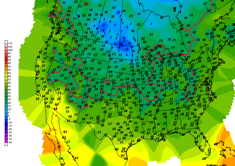 |
| US Surface Temperatures |

No need to show you Grand Rapids NEXRAD radar, as it is sound asleep with nothing to see.
Here's the forecast for Jackson and surrounding areas including Michigan Center and Rives Junction:
Today, mainly sunny, some clouds form later in the day, seasonably cool, high 44, wind NW 7-14 MPH.
Tonight, mostly clear skies, perhaps a couple of passing clouds, lows drop to 24, winds NW 5-10 MPH.
Thursday, more primarily clear skies, milder still, high 45, wind NW 5-10 MPH.
Thursday night, mainly starry skies, a clouds of floating clouds, lows near 25, wind NW 4-8 MPH.
Friday, mostly sunny, you may see a few clouds during the day, warmer, high 50.
Saturday, sunny and seasonably mild to start, some clouds start building in during the afternoon. High 55.
Easter Sunday, cloudy and rainy, high 51.
Monday, lingering clouds, some scattered showers or snowflakes still linger, sharply cooler, high only 42.
Tuesday, clearing skies, milder, high 46.
There's a look at your forecast for the next six days, I do hope that you have a great Hump Day Wednesday! Blessings.
Tuesday, March 26, 2013
Spring Will Get Here Eventually...
Good Morning.

Quiet weather here and across much of the US for the next couple of days, let's take a look and see what's running as we pop the hood:
IT STILL ISN'T FEELING LIKE SPRING MIKE!: I agree. I'm just in marketing and promotion. If you don't like the weather, design and manufacture are upstairs! All kidding aside though, the pattern we have seen for the last few days SLOWLY starts changing. Mainly cloudy for the moment, with some breaks for sun here and there, and perhaps a stray flurry or some light, non-accumulating snow on occasion. As the day progresses today, expect very slow clearing, and then a gradual switch to more sunshine than clouds over the next few days. You should see some 50's Saturday, but then we address another pattern shift following that.
WHAT ABOUT EASTER WEEKEND & SPRING BREAK?: I just discussed clearing skies above. Along with that, milder temperatures thanks to solar heating during the daylight hours. Expect 38-43 on the thermometer depending on location and how stubborn the cloud cover outside your home is. Moving ahead, let me caution you, countless things could change between now and Friday, making this forecast a moot point in a hurry; Mother Nature enjoys her unpredictability. Good Friday should be just that: A good Friday to get away for Easter or start Spring Break, Some clouds, but quite a bit of sun and milder readings into the mid or even upper 40's. Saturday is looking really good, with seasonable spring-like conditions and ample sunshine, then the shoe drops on Sunday. Cooler temperatures with some rain or perhaps even a snowflake Sunday afternoon into Monday. If you have an Easter Egg hunt planned, you'll want to get it done before about 2 PM to make sure your kids aren't after wet eggs. I don't see Sunday being a total washout by any stretch, however models are currently suggesting an even money shot at rain. Beyond that, no real warming until the end of next week, because more chilly air rolls in from Canada.
PRECIPITATION & SEVERE WEATHER: The upper pattern we are in with a big mass of colder, stable air across the eastern part of the US makes for a quiet, yawning pattern. No thunderstorm activity anywhere in the lower 48 for the next couple of days according to the Storm Prediction Center. All of our severe weather has involved that darned white fluffy stuff, and I don't see anything coming down the pike that remote resembles Spring bad weather.
Let me show you the Grand Rapids NEXRAD image, you can see some light snow falling in widely scattered fashion across the area this morning, especially west of US-131:
 |
| Grand Rapids NEXRAD Reflectivity |
And here's a look at the current national temperatures - this really paints the picture of a quiet and chilly pattern hanging tough for another few days. A big blob of cold, stable air is just sitting over the eastern three-quarters of the US like a meditating Zen master. You can forget about it leaving anytime soon, and as a result, just a few small disturbances here and there MAY create some precipitation.

Here's the forecast for Jackson and surrounding areas including Spring Arbor and Rives Junction:
Today, cloudy skies, those start thinning ever so slowly as the day progresses, high 40, wind NW 5-10 MPH.
Tonight, still plenty of clouds but they continue dissipating, lows roll back to 29, wind WNW 6-12 MPH.
Hump Day, periods of clouds and sunshine, high 41, wind NW 5-10 MPH.
Wednesday night, mainly clear and cold, lows near 24, wind NW 6-11 MPH.
Thursday, mostly sunny, a few passing daytime clouds, high 45, wind NW 5-10 MPH.
Good Friday, sunny and mild, high 47.
Saturday, sunny to start, clouds increasing during the afternoon, high 53.
Sunday, cloudy, scattered showers possible after 11AM, a bit cooler, high 49.
Monday, some clearing, not as warm, high 46.
There's a look at your forecast for the next six days, I do hope that you have a great Tuesday! Blessings.
Subscribe to:
Comments (Atom)