Saturday, April 28, 2012

Wetter, Then Warmer and Wetter...

Good Morning!


A clear, seasonably cool Friday and mainly starry night have given way to overcast skies this morning, and rain is lurking.  We'll have one more day of chilly temperatures to get through before we see warmer weather, but as the temperatures go up, so do our chances of showers and thunderstorms.  Let's take a deeper dive.


TEMPERATURES:  If you can hang in there for one more day and night, your patience should be rewarded starting Sunday.  Today and tonight look to be the last time we'll see a sub 55 daytime high and a sub-freezing nighttime low for awhile.  It's just not going to get very warm today at all, with mostly overcast skies and rain moving though in periods keeping the air cool.  The computer models are all running in the 48-51 range for the daytime high, and both the GFS and NAM are showing a low of 28 tonight, so don't be surprised to see some frost/freeze-related items coming from the National Weather Service later today.


After we make it through today, temperatures in the 60's, 70's and warmer are in the mix, with us making a hard run at 80 for Wednesday, seasonable nighttime lows in the 40's, and an occasional upper 30's low mark thrown in for variety.


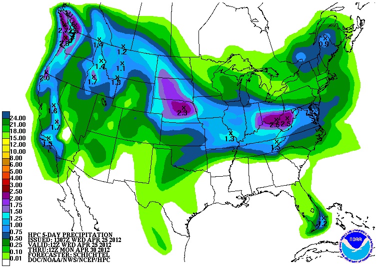
RAIN:  Currently there are some heavier showers and a couple of storms crossing Lake Michigan from Chicago.  We'll have a taste of that periodically as the day progresses, though I don't expect it to be anything too terribly wet, at least not until late morning into the afternoon. We'll be getting a little watering this next five days as this map shows.  This is the National Weather Service's idea of rain totals through 8AM Wednesday.


Rain totals are expected to come in between a half inch to 1.25 inches with totals increasing as you come south.


SEVERE WEATHER:  Nothing expected in Michigan for the next three days, but that changes.  No risk category given for thunderstorms on days one through three, so we'll keep any rains we get in the next 72 hours as showers, although a buried storm can't be ruled out.  Here's the change I mentioned, as the Storm Prediction Center is seeing a possible severe weather setup for Day 5 (May 2nd and 3rd) that includes a good chunk of southwest lower Michigan.  Here's that map.


A lot of big-picture stuff can happen in the next five days that would diminish or eliminate that threat altogether, so we'll keep an eye on it.  Long story short, if the forecast holds, it would be lower Michigan's first crack at a credible severe weather threat since the summer preview we had back in March that dropped a couple of tornadoes.  Just wanting to put that in the back of your mind as your new week starts taking shape.


Here's a look at the current radar image from Grand Rapids, showing the band of showers and storms moving on shore down by Benton Harbor, extending into Indiana, and below that is the infrared satellite image, notice the showers and storms from down by Benton Harbor and into Indiana:


And here's your local forecast for Jackson and surrounding communities including Parma and Michigan Center:


For today, cloudy skies with periods of showers and perhaps a roaming thunderstorm, high temperature 49, winds E 10-15 MPH, rain totals should top out around a quarter-inch around the area, less is on tap in many places.


Tonight, clearing skies, chilly, nighttime lows down to 28, winds ENE rolling back to between calm and 5 MPH.  Do not be surprised to see frost/freeze items coming from the NWS for tonight.


Sunday, sunny skies, warmer, high of 61, winds ENE 5-10 MPH.


Sunday night, clear skies, clouds start filtering in before daybreak, not as cold, nighttime lows of 38 with winds ESE 7-15 MPH.


Monday, clouds increase, showers and perhaps a thunderstorm, high of 68, winds ENE 7-15 MPH.


Tuesday. cloudy skies, warmer, chance of showers and thunderstorms, especially in the afternoon, high of 73.


Wednesday, clouds persist, showers and thunderstorms are likely, high near 80.


Thursday, cloudy skies, a bit cooler, showers and thunderstorms possible, high of 75.


There's a look at your forecast for the next 6 days.  I do hope you have a wonderful weekend!  Blessings.

Friday, April 27, 2012

Freeze Warning for Clinton County from 1AM through 9AM tomorrow.

Wet Saturday, Warmer Week

Just a quickie forecast today as Fridays are my hectic days, and with an energetic but stubborn 8 year-old (like dad, like daughter), mornings can be an adventure!


After we get out of the freezer this morning we'll see moderating temperatures with 70's on the table for next week.  We'll have to get through another night of chilly weather as well.  Showers are on tap for tomorrow, then it looks mainly dry, but perhaps a chance of a shower will be in the mix each day for the next few.


Severe weather is a non-resident, as the Storm Prediction Center has no severe weather risk for Michigan any of the next three days.


Currently most areas in the blog are checking in between 28 and 33 degrees with clear skies.  Here's the local forecast for Jackson County:


For today, sunny skies, warming nicely after 9AM, high temperature of 55, north winds 5-10 MPH.


Tonight, clear skies to start, clouds roll in later, not quite as cold, lows near 35, wind E 5-10 MPH.


Saturday, cloudy skies, chance of showers cool, high of 46, winds NNE calm to 5 MPH.


Saturday night, clearing skies, cold, frost of freeze advisories are possible again, lows down to 28, winds N 5-10 MPH.


Sunday, sunny, warmer, high near 62, E winds 7-15 MPH.


Monday, periods of clouds and sun, chance of showers after lunchtime, cooler, with a high of only 52.


Tuesday, cloudy skies, warmer, chance of showers or a roaming thunderstorm, high 70.


Wednesday, cloudy, chance of showers and thunderstorms, mild, high of 73.


That's a quick look at your forecast for the next 6 days, I hope you have a great Friday and an awesome weekend!  Blessings.

Thursday, April 26, 2012

Freeze Warning Update

All counties in the South Central Michigan Weather Zone are under a Freeze Warning from the National Weather Service until either 8AM or 10AM tomorrow morning.  Hillsdale and Branch Counties have had their Freeze watch upgraded to a warning, which expires at 10AM.  Temperatures in the area tonight are expected to drop as low as 25 degrees.

364, 252, 4/27/2011...

364:  Number of days that have passed since the 2011 Super Outbreak in the Deep South.
252:  Number of people that died in the state of Alabama during the 2011 Super Outbreak.
4/27/2011 :  One of the deadliest weather days ever in the history of the United States.

Tomorrow marks the one year anniversary of one of the most devastating weather days in the United States, both from a human suffering and monetary cost.

The 2011 Super Outbreak affected the Deep South, especially Mississippi and Alabama.  Dixie Alley saw severe storms setting up on the 26th, firing in the pre-dawn hours of the 27th, then briefly dissipating before re-forming and kicking off the "main event" starting at around 2PM that day.

It was watching this event that I got to know a bit more about Alabama, and meteorologists James Spann and Jason Simpson from ABC 33/40, along with Mark Prater from CBS 42 in Birmingham, Alabama.

I am not going to go down to the fine details about this day.  They are well documented in a number of places elsewhere on the web.  If you have some time, go to YouTube and search for jbbbrown2's channel, then find the clip from ABC 33/40 at 2:00 PM April 27th and start watching.  It was heartbreaking yet intense, as the day progressed, watching a tornado on live TV tear through downtown Cullman, AL, then later in the afternoon, watching as an EF4 laid waste to the southeastern part of Tuscaloosa, AL.  James and Jason did a phenomenal job covering multiple storms with tornadoes on deck and doing damage, as did Mark on the CBS station.  I say that, not to blow sunshine at people, but to give credit where it's due.  Am I a "fanboy"?  Perhaps.  If I can pull off this "mid-season" career change into meteorology, I can only hope that if I am fortunate enough to become a broadcast met or forecaster, given a similar situation, that I can do a TENTH of the job they did under the gun with lives on the line.

Sadly, despite their best efforts, and the heroic efforts of other meteorologists from the Storm Prediction Center on down the line, combined with the efforts of local emergency services workers, 252 people died in Alabama when the dust settled.

I'll be frank, I shed a few tears watching that whole thing unfold.  It still makes the hair stand up on my neck, seeing those tornadoes knife through towns like that.  I guess it was training and focus that kept James, Jason, Mark and the other meteorologists in the game when the chips were down and so much was riding on their performance.

I e-mailed James Spann about a month after the outbreak.  I won't go into detail about it, but I will say this: you could sense without even being there, that people were seriously hurting across the board.  I told James that he and all the other mets needed to hear from someone far removed from the situation that, from what I could see up here in Michigan, they did the very best they could with what they had facing them that day, and they had absolutely no reason to be down on or blame themselves.  In hindsight, that same observation goes to the emergency services personnel, and those who became first responders of all stripes in the minutes, hours, and days after the tornadoes had moved on or lifted.


In the subsequent days and weeks, I could tell a lot of the weather types involved took that event hard, and took it personally after the shock wore off.  Ever since then, the warning and forecasting process has been picked apart and re-evaluated, with changes happening, some more swiftly than others.


This is one reason why I started the South Central Michigan Weather Zone.  I hope to make a career change at some point.  If I don't, that's fine too.  I enjoy science, the weather, and trying to solve the weather puzzle daily.  I hope that if you take time to read the blog, it's been useful thus far in some small way.  Most important, I also hope that maybe, even just doing a blog on the web at the opposite end of the US, I can possibly have at least a part of a finger or a toe in preventing so many from perishing due to a weather event ever again.

Take a moment, and say a prayer or send a good thought today or tomorrow for those who are still recovering, as what was April 27, 2011 soon becomes April 27, 2012.  There are still many in Alabama that need help, as they continue to travel the road of recovery.  If you can find a way to help, that's even better. Thanks for reading.

Back to the Freezer...

Good Morning.

First, a small forecast bust to own up to:  I called for rain between 2PM and 5PM in Jackson yesterday afternoon.  It didn't show until about 6:30.  Just a reminder to me that I am not steering weather systems and they run on their own timetable - not mine.  OK, moving on:

We're in the midst of a pattern that is all too familiar to us of late.  We start to warm up a bit, some rain showers come through, and on the back side of the rain, the gates open from Canada to bring in some downright chilly air, especially for the overnight hours.  Showers and a few thunderstorms have left the state up in the northern half of the Lower Peninsula at this hour, and strong to severe storms are moving through Ohio and Kentucky, with a Severe Thunderstorm Watch up for southern Illinois, southern Indiana and Western Kentucky until 9AM EDT.  Let's take a deeper dive and see what's going on.

TEMPERATURES:  On the back side of this rain, temperatures will be cooler, and tonight the stage is set for sub-freezing temperatures.  As I indicated in my earlier warning post, Freeze Warnings are up for pretty much the entire blog area.  A lot of places will see nighttime lows into the mid 20's tonight.  That trend continues tomorrow with temperatures not making it above freezing until well after daybreak.  Skies will be clear, allowing any daytime heating to escape into the atmosphere in night.  Fortunately, we don't expect any snow.  Saturday the GFS is currently printing 49 for the high.  Once we get through this latest cold snap, temperatures will start to warm again in to the 50's with 70's on the table into next week.  Hang in there!  Here's current temperatures around the nation.  Notice the freezing line lurking just over the border into Canada...


RAIN:  Once we get this rain out of here today, our next chance at rain comes in early Saturday.  Rain totals should fall as you get away from the state line, and the latest model runs are looking  bit drier as compared to a day or so ago.  I'm thinking the south zone counties will see up to a half-inch of rain, and the north zone counties should pick up around three-tenths of an inch.  So at this point, we'll go with some scattered showers in the area throughout the day Saturday, but I'm not seeing enough rain now to totally ruin outdoor activities. I'll need to see another model run to lock that in for the weekend forecast.  After that, we'll keep the rain away for another day or so.  Here's a look at the National Weather Service's idea of rain through next Monday.

We're picking up close to an inch over the next five days, which matches up with around a half inch for this rain event and Saturday.  This is the first time that I haven't seen a wild fluctuation in the rain amount between forecasts. The middle of next week is looking pretty wet so far, again, we'll sharpen the forecast as we move closer.

SEVERE WEATHER:  We don't even get touched by a general risk for the next three days, as the bulk of the activity stays in the Tennessee Valley and foothills of Appalachia.  A "slight" risk extends through eastern Colorado, southwest Nebraska, western Kansas, and the panhandles of Texas and Oklahoma today.  Tomorrow that threat moves east a bit to Kansas, Missouri and Oklahoma.  The chasers are drawing up battle plans I'm sure.  Here's the Day 1 and 2 maps from the Storm Prediction Center.  They're valid as always, at 8AM.


Day 1
Day 2

Now let's look at the local forecast for Jackson County.


For today, cloudy skies, cooler, rain showers taper off as the day progresses, still mild, high of 59, SE winds 5-10 MPH turn northerly and increase to 10-20 MPH.


Tonight, clearing skies, then cold, frost after midnight, Freeze Warnings are in effect.  low of 25.
Winds N 5-10 MPH.


Tomorrow, clear and cooler, high of 56, winds N 5-10 MPH.


Friday night, becoming cloudy, chance of rain showers late, low of 36, winds NE 5-10 MPH.


Saturday, cloudy skies, cool, high of 49, winds NE 10-15 MPH.


Sunday, sunny, warmer, high of 56.


Monday, partly sunny skies, warmer still, chance of showers as clouds increase later in the day, high of 65.


Tuesday, cloudy skies, a 50/50 chance of showers and thunderstorms, high of 72.


There's a look at your forecast for the next 6 days, I do hope you have a wonderful day!  Blessings.

Freeze Warnings Issued (Again)...

The National Weather Service has issued Freeze Watches or Warnings for every county in the South Central Michigan Weather Zone:


North Zone:
  • Clinton County - Midnight Friday 4/27 through 10AM 4/27
  • Eaton County - Midnight Friday 4/27 through 10AM 4/27
  • Ingham County - Midnight Friday 4/27 through 10AM 4/27
  • Livingston County - 2AM Friday 4/27 through 8AM 4/27
South Zone:
  • Calhoun County - Midnight Friday 4/27 through 10AM 4/27
  • Jackson County - Midnight Friday 4/27 through 10AM 4/27
  • Lenawee County - 2AM Friday 4/27 through 8AM 4/27
  • Branch and Hillsdale Counties - Hard Freeze Watch in effect until 10AM Friday 4/27
Plants that must stay outside need to be covered, bring in any plants you can to protect them from possible damage.  Frost is expected tonight with temperatures falling into the mid 20's in several spots.

Wednesday, April 25, 2012

A Little Bit Of Everything....

Good Morning!


Some windy conditions and a lot of mainly clear skies in the area yesterday, with most places getting well into the 50's, and a couple of 60's as well.  Jackson was one of those places that saw 60 or better, with a high of 62.


The pattern starts changing, as showers and a couple of embedded storms are approaching Michigan from the west, part of a big line that currently stretches from Chicago all the way northwest into the arrowhead of Minnesota.  That line will be in here later this afternoon into tonight.  Here's the regional radar composite image of that:


Let's take a deeper dive and see what's going on...


TEMPERATURES:  We'll see temperatures hitting 60 or better again today in front of the rain mentioned above.  After that moves through, we start rolling back into the 50's for the rest of the week, and Saturday looks to be chilly!  Thursday night into Friday, we may see some patchy frost as sub-freezing lows creep in again.  The GFS (one of our fearless computer models) is showing a high of 49 for Saturday and that's it.  After that, temperatures warm back into the 60's and higher for the first week of May.  Longer-range, 70's and maybe even 80 is being put on the table.  That's still a ways off though, and any forecast that far out is speculation at best.


RAIN:  Two shots of rain are possible for south-central Michigan with a bit of drying between the two.  Wave one is tracking this way as I write the forecast today, you saw it in the radar composite.  Best estimates right now indicate that it should be here about time school dismisses, so we'll say between 2PM and 5PM rain should start, and expect a wet commute home from work today.  This event will have mostly showers, but an occasional buried thunderstorm could be there as well.  We'll keep the rain around most of tonight, and things should be pretty dry by the morning commute tomorrow.


Wave two comes in on Saturday.  That one is a little trickier to nail down.  Current modeling suggests Saturday's rain will be a morning affair for primarily the south zone counties of the blog, courtesy of an upper level disturbance passing just south of Michigan.  If you're at or north of I-96, so far it looks like you'll stay dry, albeit with some clouds on Saturday.  We'll go with a chance of scattered showers south, a chance of an isolated or widely scattered shower north.  It's not looking very wet in south central Michigan in any case for the next five days, here's the National Weather Service's idea of rain totals for that period.


There's half to three-quarters of an inch of rain expected in the forecast area over the next five days.


SEVERE WEATHER:  Today, Michigan is under a "general" risk for thunderstorms.  ANy that do fire, we expect to be your plain vanilla everyday storms that typically don't do much more than make some light and noise, and rain on you before they dissipate.  Just off to the southwest of us, there's a "slight" risk for severe weather.  Here's the Day 1 forecast from the Storm Prediction Center outlining the risk categories.  Maps are valid at 8AM as always during Daylight Savings Time.


Day 2, we drop out of the thunderstorm risk altogether, and the "slight" risk pushes way back west to the Central and High Plains of Nebraska, Kansas, and Colorado.  Here's that map.


More blue skies than gray in Jackson County right now, here's the satellite image showing that line of wet stuff off to the west...


And here's the forecast for Jackson and surrounding communities including Concord and Grass Lake:


For today, sunny skies, clouds increase as the day wears on , showers likely after 2PM, high temperature of 60, winds SE 10-15 MPH.


Tonight, showers, an embedded thunderstorm can't be ruled out, low 45, winds SSE 5-10 MPH.


Thursday, cloudy skies, showers early then clearing, high of 61, winds swing around from SE to NNW, 10-15 MPH.


Thursday night, mainly starry skies, colder, some patchy frost possible in lower-lying areas, lows near 30, winds N 5-10 MPH.


Friday, sunny, cool, high of 53, winds N 5-10 MPH.


Saturday, partly cloudy skies, a chance of a scattered shower or two, high of 49.


Sunday, sunny, warmer, high of 60.


Monday, sunny to start, clouds increase with a chance of showers later in the day, high of 62.


That's a look at your forecast for this hump day Wednesday, I do hope you have a wonderful day!  Blessings.

Tuesday, April 24, 2012

Sunny, Warmer...For a Bit

Good Morning!


We have started a beautiful day in Jackson, with temperatures already into the 40's and no frost or freeze issues from the prior night.  We haven't been able to say that in the last few days!


The late season snowstorm is FINALLY beginning to wind down a bit out east, with some spots in NY and PA reporting up to a foot of snow in higher elevations.  Most places out there that had snow saw 3-6 inches of snowfall since the whole event started late Sunday into early Monday.  There is still some snow falling, especially higher up in connection with the storm.


The low that is powering that storm will eventually migrate northward into Canada and take the rain and snow along with it.  Earlier this morning there were some showers that were being spun off by the low reaching into the thumb of Michigan, those have since tapered off as the low shows some indications of movement.


Closer to home, the mercury goes up a bit, but the chance for showers increases as well, especially for the weekend.  Let's take a look...one deeper dive coming up!


TEMPERATURES: Temperatures start to moderate just a touch, as the entire pattern over the US resets itself a bit.  The strong storm system over the Northeast retreats into Canada, breaking the logjam aloft and allowing the ridge that has kept the West warm to start expanding it's reach toward us.  Winds turn southwesterly and warmer air starts to filter in on the front slope of the warm air dome.  Currently the NAM is printing 68 as a high for Thursday, but for my money, right now that seems a little ambitious. We'll back that off and say 65 for the high, then cool it back down to the 50's for the weekend.  More on this below, but the models are all saying that a surface low riding the front side of the ridge like a surfer rides a wave on water will push through, kicking off some rain as it does.


RAIN:  We had a little bit of rain filter into the thumb off the backside rotation of that storm system that dropped all the rain and snow in the Northeast.  That's long gone now.  Our next shot at rain in South Central Michigan looks like tomorrow night into Thursday, with perhaps a passing shower or two, and then we get a more sizable risk of rain Saturday.  The Saturday event looks wetter and longer duration than the Thursday one on the current model run, and I can buy that, based on a forecast surface low with decent mid-level support riding a west wind without having to detour around a ridge or trough.  Here's what the National Weather Service's idea of the next 5 days looks like rain wise:


The bottom three counties in the South zone could see up to three-quarters of an inch of rain, with less as you go north.  That will change though, because rarely does a surface low track remain constant over repeated analysis, and a slight change can re-shuffle the deck as far as rain totals.  We'll see about it.


SEVERE WEATHER:  That picture has changed dramatically from yesterday.  I was reporting how quiet it looked to be for the next few days in my last forecast, and now here we are with severe weather knocking on the door, just to our southwest over IL, IN, OH, and KY.  Michigan is NOT in an elevated risk area at this point, so I can still say that we have just the chance of garden variety thunderstorms right now.  Any that do form, if they get strong, will just blow on us and maybe drop some small hail.  I don't see a lot of precipitation coming out of any storms that do form, and that's backed by the not very wet 5-day forecast from the National Weather Service.  Here's a look at the severe weather picture.  Each map is as always, valid at 8AM that day...


Here's Day 2, showing the closest severe risk to Michigan over the next 72 hours.  With the "slight" risk being southwest of us in warmer air, that could expand northeast into Michigan.


Here's a look at current conditions and the Grand Rapids radar image:  Clear as a bell in Jackson currently.


Now for the local forecast for Jackson and surrounding communities including Vandercook Lake and Rives Junction:


For today, mostly sunny skies, windy, high temperature of 57, winds NW 10-20 MPH.


Tonight, mainly starry skies, perhaps a passing cloud or two, nighttime low of 35, NW winds turn west and taper off to 5-10 MPH.


Wednesday, clear skies and warmer, we'll start to pick up some clouds later in the day as the warmer air begins venturing in - high of 64, winds WSW 5-10 MPH.


Tomorrow night, cloudy skies, a slight chance of an isolated shower, low of 48, winds WSW 5-10 MPH.


Thursday, cloudy skies early then clearing, chance of showers before 2PM, high of 65, winds SW 5-10 MPH.


Friday, clear skies to start, then clouding up later in the day, high of 50.


Saturday, mostly cloudy, chance of scattered to numerous showers, high of 53.


Sunday, showers clear off, then becoming sunny, high of 56.


Monday, sunny, pleasant, high of 58.


There's your forecast for this Tuesday.  I do hope you have a wonderful day!  Blessings.

Monday, April 23, 2012

Cool Today, Warming Wednesday...

Good Afternoon!


It was another cool start to the day here in South Central Michigan.  Freeze Warnings were up for most counties covered by the Blog, though they have long expired.  I'll tell you what - I'll take a Freeze Warning over the Winter Storm Warnings out east any day of the week.  Several inches of snow have already fallen in NY State and Pennsylvania, and it's still going.  This is also that heavy wet snow that downs trees and power lines, and can cause health problems for people out there trying to move it.  Just look at this radar composite image of that belt of snow out east!


One (not so) deep dive coming up:


TEMPERATURES:  We'll see temperatures cold during the night for another night and 50's during the day, then things start to moderate a bit for Wednesday, as we'll hit 60 and stay above freezing at night, with winds slowly starting to swing around to the south as the big ridge out west finally starts moving eastward a bit, allowing warmer air to roll in.


RAIN:  We'll have a chance at a shower or two on Thursday, as a rather disorganized surface feature tracks south of us.  The models have it closing off to a bona fide low, then re-opening and becoming more of an upper level low a couple of times while traveling between now and Thursday, so any rain that we get from it should be minimal.  Here's the National Weather Service's idea of rain totals for the next five days.


SEVERE WEATHER:  Nothing even CLOSE to Michigan for the next three days.  In fact, there's no severe weather threat anywhere in the US for the next three days, just your typical garden variety spring thunderstorms are forecast, where you might have some gusty wind and small hail.


It's a bright sunny day in South Central Michigan, here's a look at the radar and some current observations, now that my primary source for radar images is partly back on-line after the first of some improvements:


Clear skies with low 50's being reported pretty much through the entire area of the blog.


Here's the local forecast for Jackson and surrounding communities including Parma and Brooklyn:


For today, mostly sunny skies, warming, high of 57, winds N 10-15 MPH.


Tonight, starry, clear skies, cold, patchy frost is definitely possible, lows down to 31, don't be surprised to see frost or freeze warnings issued later today.


Wednesday, sunny to start, then increasing clouds with a chance of a late day shower, high 60, winds NNW 7-15 MPH turning SW as the day progresses.


Wednesday night, cloudy skies, with a chance of a passing shower, low of 42, winds SW 5-10 MPH.


Thursday, sunny, high 57, winds S 7-15 MPH.


Friday, sunny to start, clouds increase throughout the day, a bit cooler, high 56, winds S 7-15 MPH.


Saturday, cloudy skies, a chance of a shower, high near 53.


Sunday, a few peeks of sunshine but mainly cloudy, cool, high of 50.


There's a look at your forecast into Sunday, I do hope you have a wonderful day!  Blessings!

Sunday, April 22, 2012

Freeze Warnings Issued

Good Evening.

The National Weather Service has issued a Freeze Warning for the following counties in the South Central Michigan Weather Zone:

South Zone:
  • Branch
  • Hillsdale
  • Calhoun
  • Jackson
North Zone:
  • Eaton
  • Ingham
  • Clinton
This is in effect from 2AM until 9AM Monday, 4/23/12.  Damage to plants and tender vegetation can result if not covered or brought inside away from the cold.

Chilly Weather on Tap...

Good Morning!


We start the day with mixed clouds and sunshine and get a bit warmer, then go back into the freezer for tonight.  There are Freeze Watches up for Branch and Hillsdale County through tomorrow.  Nighttime lows will flirt with 30 degrees or lower throughout the area.  Let's get right to it.


TEMPERATURES:  We'll keep seeing temperatures in the 50's though it will warm a couple of degrees each day, with chilly nights.  Computer models are predicting sub-freezing temperatures for the next two nights.  Wednesday we'll get a break from this chilly air as a ridge pushes in here from the southwest, briefly moderating temperatures and warming us back to the mid 60's, before the daytime 50's then freezing nights pattern resumes until the weekend.  Here's current temperatures around the US:


RAIN: It looks like Wednesday night into Thursday will be our next good chance at some showers or storms, and that lines up with the expected arrival of the warmer air as ridging building in from southwest of us arrives.  It's looking pretty dry here in South Central Michigan, and the 5-day precipitation forecast from the National Weather Service backs that up.  Here's the map.  At most, a half-inch of rain in Michigan for the next 5 days.


Take a look out east though, man oh man, what a storm is shaping up out there!


SEVERE WEATHER: Nothing here for the next 3 days.  In fact, there's no severe weather forecast anywhere, except for the Outer Banks of North Carolina as the storm system tracks up the east coast and cranks up into a full-blown Nor'Easter.  I will forgo the severe weather maps right now since the severe threat to Michigan is so far removed, and minimal across the nation in general.  We'll update it if we need to as the day progresses.  Most of Indiana and Eastern Ohio is under a Freeze Watch through tomorrow morning at 8AM.


It's time for the local forecast for Jackson County:


Today, a mix of clouds and sunshine, breezy and cool, high temperatures near 53, NE winds 10-20 MPH.


Tonight, clear and cold, don't be surprised to see weather advisories for the freezing weather, lows down to 29, N winds 7-15 MPH.


Back to work on Monday with clear skies, a touch warmer, high temperature 56, winds N 7-15 MPH.


Monday night, clear and cold, nighttime lows down to 30, winds N 7-15 MPH.


Tuesday, mainly sunny, a few passing clouds, highs near 57.


Wednesday, sunny skies, clouds later on with a chance of showers or a thunderstorm, high near 63.


Thursday, cloudy skies to start with chance of lingering rain showers, then clearing, cooler,  high near 52.


Friday, clear and cool, high of 53.


That's a look at your weather for this Sunday, I do hope you have a great day!  Blessings.
Freeze Watch for Branch and Hillsdale Counties until 8AM Monday morning.