Some windy conditions and a lot of mainly clear skies in the area yesterday, with most places getting well into the 50's, and a couple of 60's as well. Jackson was one of those places that saw 60 or better, with a high of 62.
The pattern starts changing, as showers and a couple of embedded storms are approaching Michigan from the west, part of a big line that currently stretches from Chicago all the way northwest into the arrowhead of Minnesota. That line will be in here later this afternoon into tonight. Here's the regional radar composite image of that:

Let's take a deeper dive and see what's going on...
TEMPERATURES: We'll see temperatures hitting 60 or better again today in front of the rain mentioned above. After that moves through, we start rolling back into the 50's for the rest of the week, and Saturday looks to be chilly! Thursday night into Friday, we may see some patchy frost as sub-freezing lows creep in again. The GFS (one of our fearless computer models) is showing a high of 49 for Saturday and that's it. After that, temperatures warm back into the 60's and higher for the first week of May. Longer-range, 70's and maybe even 80 is being put on the table. That's still a ways off though, and any forecast that far out is speculation at best.
RAIN: Two shots of rain are possible for south-central Michigan with a bit of drying between the two. Wave one is tracking this way as I write the forecast today, you saw it in the radar composite. Best estimates right now indicate that it should be here about time school dismisses, so we'll say between 2PM and 5PM rain should start, and expect a wet commute home from work today. This event will have mostly showers, but an occasional buried thunderstorm could be there as well. We'll keep the rain around most of tonight, and things should be pretty dry by the morning commute tomorrow.
Wave two comes in on Saturday. That one is a little trickier to nail down. Current modeling suggests Saturday's rain will be a morning affair for primarily the south zone counties of the blog, courtesy of an upper level disturbance passing just south of Michigan. If you're at or north of I-96, so far it looks like you'll stay dry, albeit with some clouds on Saturday. We'll go with a chance of scattered showers south, a chance of an isolated or widely scattered shower north. It's not looking very wet in south central Michigan in any case for the next five days, here's the National Weather Service's idea of rain totals for that period.
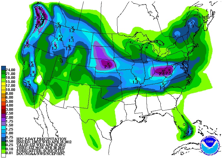
There's half to three-quarters of an inch of rain expected in the forecast area over the next five days.
SEVERE WEATHER: Today, Michigan is under a "general" risk for thunderstorms. ANy that do fire, we expect to be your plain vanilla everyday storms that typically don't do much more than make some light and noise, and rain on you before they dissipate. Just off to the southwest of us, there's a "slight" risk for severe weather. Here's the Day 1 forecast from the Storm Prediction Center outlining the risk categories. Maps are valid at 8AM as always during Daylight Savings Time.

Day 2, we drop out of the thunderstorm risk altogether, and the "slight" risk pushes way back west to the Central and High Plains of Nebraska, Kansas, and Colorado. Here's that map.

More blue skies than gray in Jackson County right now, here's the satellite image showing that line of wet stuff off to the west...

And here's the forecast for Jackson and surrounding communities including Concord and Grass Lake:
For today, sunny skies, clouds increase as the day wears on , showers likely after 2PM, high temperature of 60, winds SE 10-15 MPH.
Tonight, showers, an embedded thunderstorm can't be ruled out, low 45, winds SSE 5-10 MPH.
Thursday, cloudy skies, showers early then clearing, high of 61, winds swing around from SE to NNW, 10-15 MPH.
Thursday night, mainly starry skies, colder, some patchy frost possible in lower-lying areas, lows near 30, winds N 5-10 MPH.
Friday, sunny, cool, high of 53, winds N 5-10 MPH.
Saturday, partly cloudy skies, a chance of a scattered shower or two, high of 49.
Sunday, sunny, warmer, high of 60.
Monday, sunny to start, clouds increase with a chance of showers later in the day, high of 62.
That's a look at your forecast for this hump day Wednesday, I do hope you have a wonderful day! Blessings.
No comments:
Post a Comment