Friday, June 8, 2012

Sunny Summer Days...

Good Morning!


A fine summer weekend is on tap with warming temperatures and plenty of sunshine.  Kids and teachers should be out of school or about done, they'll have a fine weekend to kick off their summer vacation!  Rain chances look pretty low, but I can't rule out a pop-up shower or storm.  Anything we see should be widely scattered, non-severe, and mainly concentrated in the afternoon and evening hours.  One deeper dive on the way!


TEMPERATURES:  We are getting toward the end of the northwesterly flow coming out of Canada.  That's what has been holding temperatures down with dry conditions.  The ridge that we have been under for the last several days starts flattening out today, resulting in winds starting to turn more westerly.  Modeling indicates that wind shift will start tonight.  As that happens we'll see temperatures creeping up into the mid 80's by the end of the weekend with some spots making a run at 90.  Dew points and humidity also start creeping up as the air gets more moisture.  I don't expect any blistering heat like what we had Memorial Day weekend, but it'll be plenty warm for a day out on the beach, or in the pool or lake.  The new work week starts warm, then cools off.


RAIN:  The National Weather Service is predicting a more uniform rainfall now, with pretty much the entire Lower Peninsula looking to pick up between a quarter to a half-inch of rain the next five days.  I know no one wants to hear it, but the fact is we can use some rain here in South Central Michigan.  We finished May a couple of inches light on rainfall, and the total gap is growing each day.  So while the outdoor plans have a big green light, you'll need to keep the sprinklers on for the lawn to stay green.  Here's a look at the 5 day precipitation map from the NWS...


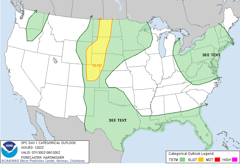
SEVERE WEATHER:  According to the Storm Prediction Center, the western part of the Upper Peninsula is the only part of Michigan where any risk is expected, and it's the "slight" risk category.  The north half of the Lower Peninsula is under a "general" risk for wet stuff.  If you look at the Day 1 map, you see the three "slight" bullseyes up north on the US/Canada border.  They match up with the flow on the trough-ridge-trough setup we have been under.  An upper disturbance is causing the fuss in MT, ND, WI and MI, and the "slight" bullseye in New England has a good deal of energy bottled up in the bottom of the trough, creating that risk bullseye.  Here's a look at the maps for Days 1 and 2, valid at 8AM EDT each day:


 Day 1
Day 2

As you can see not much regarding severe weather after today, except maybe the Upper Peninsula.


Bright blue skies in Jackson at this hour, with a few wispy clouds.  Here's the visible satellite image for you...


There's some cloud cover north of us with a solitary shower or two north of Shiawassee County, up near Saginaw and Midland.  Here's the Grand Rapids NEXRAD to look at those showers...


Here's a look at the local forecast for Jackson County:


Today, sunny, gentle breezes, some passing afternoon clouds, warm, high 83, winds turning W 7-14 MPH.


Tonight, mainly starry skies, still breezy with a few passing clouds, low 59, WSW winds 6-12 MPH.


Saturday, break out the sunscreen and cold drinks!  Abundant sunshine, maybe a cloud or two in the afternoon, not as breezy, warmer, high 85, winds SW 5-10 MPH.


Saturday night, mostly clear skies mild, nighttime lows only roll back to 61, winds SW 3-8 MPH.


Sunday, mainly sunny skies, with clouds slowly creeping in during the afternoon, very warm with a chance of an isolated shower or rogue thunderstorm, high 87.


Monday, mostly cloudy, cooler but more humid as dew points creep up to the mid 60's, a chance of showers and thunderstorms during the afternoon, high 80.


Tuesday, still cloudy, a chance at scattered showers and thunderstorms through mid-afternoon, high 82.


Wednesday, clouds and sunshine mix and match during the day, not as warm, high 75.


There's a look at your forecast for the next six days, can you believe that Father's Day is just around the corner, and here in South Central Michigan, the NASCAR invasion is spooling up as race weekend is a week away, with fans converging on Michigan International Speedway in Brooklyn.  We'll see what's on tap for that soon!  Have a fantastic Friday!  Blessings.

Thursday, June 7, 2012

Warm, Summery Weekend Coming - Along With Changes...

Good Morning!

We have yet another nice day in store in south central Michigan with temperatures around 80 and plenty of sunshine.  The bigger picture is that the big ridge that has kept our weather so benign for the most part for the last week is finally starting to break down. Systems that have had to climb the ridge to get this way will finally start having the ability to travel more directly west to east.  Let's take a deeper dive and see what we have...

TEMPERATURES:  As the upper ridge starts to flatten a bit and move to the east, winds will shift and warmer, moister air filters in on southwesterly winds.  With that warmer air, we'll see the thermometers climb well into the 80's before the weekend is done, and 90 is not out of the question in some spots.  Dew points will rise into the 60's.  After that, temperatures will fall back into the 70's.

RAIN:  The National Weather Service is predicting a fairly dry five days for us in the blog area.   We could pick up a stray afternoon shower or storm despite that, as the ridge we have been sitting under hasn't been so powerful as to prevent any convection at all from occurring.  We had some showers and thunderstorms fire yesterday evening well to the north, then they moved basically due south until they got south of I-96 and into the north zone of the blog, where they fell apart.  Here's the 5 day precipitation forecast map:


The half inch or better area is way north near the top of the mitten.  Rain chances will increase next week as that southwest flow establishes throughout the area and we get moister air from the south, as opposed to the drier, cooler flow from Canada.  So far the computer models seem to like Tuesday as the next big rain-making chance for the area, and we'll take it!  Pretty dry in this neck of the woods thus far.

SEVERE WEATHER:  We don't expect any severe weather in the area the next three days, with the exception of your garden variety thunderstorms today and tomorrow, and today is the better bet of the two according to the Storm Prediction Center.  Just a couple of "general" risk areas for Michigan.  Here's those maps for you:


 Day 1
Day 2

Notice the "slight" risk for severe weather way in the western Upper Peninsula for tomorrow.


Bright blue skies in Jackson at this hour with the visible satellite image to back that up...


The Grand Rapids NEXRAD radar is sound asleep with nothing showing on it but ground clutter.


Here's the forecast for Jackson and surrounding communities including Hanover-Horton and Concord:


For today, sunny skies, gentle breezes and pleasant, perhaps the chance of a stray shower or a hit and run thunderstorm in the evening, high 80.  Winds N 5-10 MPH.


Tonight, clear skies, cool, low of 51, winds turning westerly 3-8 MPH.


Friday, sunny skies, warmer, nice.  High 81, winds W 8-15 MPH.


Friday night, mostly starry skies with a few passing clouds and a low down to 58, winds SW 6-12 MPH.


Saturday, periods of clouds and sunshine, warmer still with a high of 84.


Sunday, partly sunny, breezy and warm, a chance of an isolated afternoon or evening shower or roaming thunderstorm, high 86.


Monday, variably cloudy skies persist, still the chance of an isolated or widely scattered shower, high 87.


Tuesday, cloudy, a chance of scattered showers and thunderstorms, not quite as warm, high 82.


There's a look at your forecast for Jackson for the next six days, I do hope you have a great Thursday!  Blessings.

Wednesday, June 6, 2012

Special Weather Statement Shiawassee - Thunderstorms with pea sized hail and strong winds. Storms moving at 20 MPH.

Mild Now, Warm Weekend Ahead!

Good Morning!


Full day ahead today, so let's get straight to the deeper dive.


TEMPERATURES:  We'll be right in the ballpark of our normal high for this time of year,  which is around 78.  The warming trend continues with a bit of a jump tomorrow instead of sneaking up a couple of degrees each day, getting into the 80's in time for the weekend, then climbing even more to make a run at 90 for Sunday.

RAIN:  This forecast seems to get a little drier each day.  The National Weather Service forecast for rain the next five days is simply put, a lack of it!  Bone dry here, up to a quarter-inch in the northern part of the mitten and in the Upper Peninsula.  Here's a look at that map for you.  The map is good through 8AM June 11th.


With that being said, the computer models are arguing about the chance of an isolated shower or perhaps a thunderstorm the next day or two.  The GFS says we'll be bone dry, and the NAM likes a one in three shot at rain.  For my money, dry looks better, based largely on the prevailing "big-picture" pattern.  Now, if we continue to see afternoon clouds develop like we have the last couple of days, toss in a little energy from any disturbance that is just wandering by in the upper atmosphere, and an isolated shower or lone thunderstorm become a possibility.


SEVERE WEATHER:  The Storm Prediction Center doesn't expect anything here in Michigan the next three ys, other than the "general" risk for plain vanilla garden variety thunderstorms today for most of the state.  Days two and three, just the western Upper Peninsula has that "general" risk or a 5% chance under a "see text" box.  Here's the map from SPC valid today at 8AM:


Grand Rapids NEXRAD radar is all quiet at this hour, and the visible satellite image shows clear skies in south central Michigan, with just some broken clouds off to the northwest.


Here's the forecast for Jackson and surrounding communities including Rives Junction and Vandercook Lake...


Today, mainly clear skies until late afternoon, then increasing clouds.  Seasonable and pleasant, high 75.  Winds NNW 5-10 MPH.


Tonight, a mix of stars and clouds, cool, some spots could possibly see a lone shower, low 49, winds N 3-8 MPH.


Thursday, bright blue skies and nice, high 78.  WInds N 5-10 MPH.


Thursday night, lots of stars, seasonable,  Low 52, winds N 3-7 MPH.


Friday, more of the same...abundant sunshine, a few scattered clouds, warmer, high 82.


Saturday, plenty of sunshine, a chance at a stray shower late in the day, warmer still, high 85.


Sunday, a mix of clouds and sunshine, temperatures continue to climb with a high of 87, some spots could easily notch a 90.


Monday, mostly cloudy skies, not quite as warm, scattered showers and perhaps a couple of random thunderstorms are possible, high 84.


That's your forecast for the next six days, I do hope you have a wonderful hump day Wednesday!  Blessings.

Tuesday, June 5, 2012

Some Clouds, Some Sun, Getting Warmer...

Good Morning!


Our quiet weather pattern continues with some small changes here and there. The biggest variable is temperatures climbing a bit each day as warmer air slowly eases in.  Nationwide, still not much change in the big picture.  We have a high amplitude trough-ridge-trough pattern in place across the US, so sitting on the back slope of the central ridge, we tend to get cooler, drier northwesterly flow with love from Canada, as opposed to moister, warmer air from the southwest or off the Gulf of Mexico.  Big weather makers have a hard way to go bulldozing through the front of a ridge, so they move with the flow, climbing the ridge (if they can) then coming down the back side.  Yes, that's an oversimplified explanation, but it helps you see in your mind what's going on regarding the pattern we're in.  I'll also toss in a map of winds at 500 millibars, or 18,000 feet where the jet airplanes play as a visual aid...


The black lines are height contours, color fills are spots of high vorticity.  See how the general shape of the black lines is not too unlike a wave?  I'll do a post and explain those for you later today, time permitting.


Let's shift gears and go to a deeper dive regarding what we'll get here the next few days:


TEMPERATURES:  As indicated above and in yesterday's post, the forecast remains largely intact, with some turning of the temperature knob toward the warmer setting, and perhaps some cloud cover changes.  We'll be in the upper 60's and 70's for daytime highs now, but expect 80's in time for the weekend.


RAIN:  Looking at computer modeling, I don't expect any major rain players the next few days.  That being said, it is summer in the midwest, and as the warmth returns, our chances of a few scattered afternoon showers or a roaming thunderstorm go up a bit each day.  That's just a keep it in mind type of thing, as I expect most places to remain dry the next several days.  Here's what the National Weather Services thinks as far as us getting some rain in here the next five days...


Basically all of Michigan will top out around a half inch of rain over the next five days.  For the record, one of our fearless computer models, the GFS, is suggesting a widely scattered shower or pop-up storm is possible each evening the next couple of days.


SEVERE WEATHER:  Nothing around here the next three days.  The Storm Prediction Center has us just under the "general" risk of plain vanilla thunderstorms.  The Deep South and Montana are in the "slight" risk today, with Colorado and Nebraska in a bullseye tomorrow.  SPC is thinking that some severe weather could occur in the Dakotas and hug the Canada/US border as it tracks east starting Saturday.  We'll keep an eye on that and see what SPC says later today before we toss it into the mix here on the blog.


Here's a look at the visible satellite image and the Grand Rapids NEXRAD radar.  Some cotton ball cumulus on the satellite, enough to blot out the sun now and again briefly, and nothing on the radar except ground clutter.


Here's the local forecast for Jackson County:


Today, a mix of clouds and sunshine, perhaps the chance of an isolated shower late today, with a high of 70.  Winds NE 7-14 MPH.


Tonight,  some stars and clouds, cool, possibly a lone shower or two, low 49, winds N 5-10 MPH.


Wednesday...plenty of sunshine with some clouds moving through, again the outside chance of an isolated shower in the afternoon, high 74, winds N 7-14 MPH.


Wednesday night, still that mix of clouds and stars, cool, low 49.  Winds N 5-10 MPH.


Thursday, mostly sunny, some clouds, a touch warmer with a high of 76.


Friday, more of the same...abundant sunshine, scattered clouds, add a few degrees to the thermometer, high 82.


Saturday, you guessed it - sunshine aplenty, a few clouds for variety, warming a bit more, high 85.


Sunday, partly sunny, warm, chance of a scattered shower or thunderstorm in the afternoon, high 85.


There's a look at your six day forecast, I do hope you have a great Tuesday!  Blessings.

Excuse Me While I Reset The Clock...

Hello!


Don't ask me how I have managed to do it so long, but I have been converting times incorrectly for you for at least two or 3 weeks now!  Pout.  By way of explanation, weather and aviation interests world wide need to be on the same clock so they know how old information is.  Because of this need, they use Universal Coordinated Time, also known as UTC or Zulu (Z) Time.  I have been subtracting the wrong number of hours to convert it to local time for you here.  Michigan and the Eastern Time Zone is four hours behind UTC during Daylight Savings Time, and five hours back during Standard Time.  So 1200 UTC or 1200Z, which is a standard time for weather observations to occur, is always 8AM Eastern Time.  I have been saying that maps at 1200Z are valid at 7AM, getting my conversions backward, when it should be 8AM.  Sorry about the mix up!

Monday, June 4, 2012

Shhh...Quiet Pattern Working...Change The Temperature For Variety...

Good Morning!  A quiet, routine pattern has established itself for the area, and I don't see that changing for the next several days.  Sun, mild, dry.  Let's take a deeper dive and see why we're getting that!


TEMPERATURES:  We'll stay right around seasonable levels for the next several days, with no wholesale changes to the weather pattern expected.  The air masses are pretty much locked in where they are now, or being slowed way down and/or diverted in their eastward progression across the US, with just a few disturbances here and there.  As a result, fairly dry and stable air for Michigan with low humidity off a northwesterly flow results in a benign pattern.  Temperatures set up shop in the 70's and remain there until later this week, when the warmer, more summer-like air returns in time for the weekend, bringing 80s or better back to the area.  Here's a look at the temperatures around the nation at this hour.


RAIN:  Still a pretty dry look for Michigan.  We could use some rain, as we were light last month, and that trend is continuing, according to the National Weather Service...here's their idea of rain for the next five days...


Computer modeling doesn't show any big rainmakers coming down the pike for the next few days, owing to the upper air flow mentioned above.  That's why we have been dry and "air-conditioned" the last few days, and that trend should continue.  We'll be lucky to pick up a half inch of rain the next five days.  Keep watering the lawn!


SEVERE WEATHER:  Nothing close to us here in Michigan for the next few days, unless you count the "general" risk of garden-variety stuff in the west half of the Upper Peninsula.  There's is quite a bit of slight risk in the nation though, and for that reason I am including the maps.  Here's a look at the maps from the Storm Prediction Center for today and tomorrow.  As usual, these are valid at 7AM EDT each day.


 Day 1
Day 2
Notice the "slight" risk way up in the northwest - you don't see that too often.  There's a 30% risk running around in that "slight" area too, that's something to pay close attention to.  In addition, there is a slight risk at the extreme south end of Tornado Alley including a sliver of New Mexico, then another "slight" risk starting in southern Illinois and tracking southeast all the way into Georgia today.  Here in Michigan, passing clouds mixed with abundant sunshine and mild temperatures.  Severe weather...go fish!


Lots of sunshine with a smattering of high clouds in Michigan right now on the visible satellite image, and the Detroit NEXRAD radar is sound asleep, with no activity on it.  In a nutshell, if you could make the days of the week switch places, the forecast for one should still hold with almost no changes all week!


Here's the local forecast for Jackson County:


For today, mostly sunny skies with a few passing clouds, cool and comfy with a high of 72.  Northerly winds 7-14 MPH.


Tonight, a mixture of stars and clouds, cool, low 48, winds N 5-10 MPH.


Tuesday, a rewind and repeat of Monday.  Mainly sunny with a few scattered clouds, a bit warmer with a high of 75.  Winds NE 7-14 MPH.


Tuesday night, another instant replay of the previous night.  Lots of stars with some clouds occasionally, cool, low 49, winds N 5-10 MPH.


Wednesday, another press of the rewind and play buttons...plenty of sunshine with some clouds moving through, high 74, winds N 7-14 MPH.


Thursday, mostly sunny, some clouds add a bit of decoration to the sky, warmer with a high of 76.


Friday, more of the same...abundant sunshine, scattered clouds, add a few degrees to the thermometer, high 82.


Saturday, you guessed it - sunshine aplenty, a few clouds for variety, warming a bit more, high 85.


That's a look at your very quiet forecast for the next six days, I do hope you have a great Monday!  Blessings.

Sunday, June 3, 2012

Deeper Dive For Sunday...

With a break in the action here, I figured now is a good time to try my remote setup and feed the blog.  As promised, a bit of a deeper dive discussion for today's post:

TEMPERATURES:  You'll see temperatures at or just a touch below normal the next few days, but they will be seasonable, and you will enjoy the abundant sunshine.  North breezes will keep us air conditioned and the humidity down.  We stay in the 70's until the coming weekend, when we get into 80's and more summer-like conditions.  That holds true for pretty much the entire blog area, with the exception of the far south zone, where you may see an 80 or two running loose on Thursday.  Here's a look at temperatures around the US right now:


RAIN:  Not that we can see now.  We are looking at a pretty dry 5 day stretch here in south central Michigan.  We can really use the rain, as most places are running at least an inch or better below normal.  Jackson and Lansing both look dry for the next five days.  Here's a look at the map from the National Weather Service of the next 5 days worth of rain...


SEVERE WEATHER:  Just a chance of a pop-up regular thunderstorm way east, over into the Detroit metro area and up into Port Huron and the eastern part of the thumb.  Other than that, low rain probabilities and no severe threat noted.


Grand Rapids NEXRAD is quiet, and here's the visible satellite image with bright blue skies all over the blog!


There's your discussion for today!  Have a good one! 

Summer Will Be Back, Hang In There!!!


Abbreviated format today, just the forecast for you as I have to head out to a soccer tournament here shortly.  As time permits, I'll flesh this out with a deeper dive.


Today, mainly clear skies, a few scattered clouds here and there, seasonable and warmer, high 75, winds WNW 10-15 MPH.


Tonight, mainly starry skies, again, a few clouds clouds move through, lows down to 51, winds N 5-10 MPH.


Tomorrow, more clouds than sunshine, chance of an isolated shower, high 73.  Winds N 8-15 MPH.


Tomorrow night, partly cloudy skies, cool, low 49, winds N 6-12 MPH.


Tuesday, mainly cloudy with a few rays of sunshine, a bit cooler with a high only 70.


Wednesday, some sunshine with clouds, high 72.


Thursday, partly sunny, high 75.


Friday, sunny and mild, high 77.


That's a look at your forecast for the next six days, I do hope you have a great Sunday!  Blessings.