We have yet another nice day in store in south central Michigan with temperatures around 80 and plenty of sunshine. The bigger picture is that the big ridge that has kept our weather so benign for the most part for the last week is finally starting to break down. Systems that have had to climb the ridge to get this way will finally start having the ability to travel more directly west to east. Let's take a deeper dive and see what we have...
TEMPERATURES: As the upper ridge starts to flatten a bit and move to the east, winds will shift and warmer, moister air filters in on southwesterly winds. With that warmer air, we'll see the thermometers climb well into the 80's before the weekend is done, and 90 is not out of the question in some spots. Dew points will rise into the 60's. After that, temperatures will fall back into the 70's.
RAIN: The National Weather Service is predicting a fairly dry five days for us in the blog area. We could pick up a stray afternoon shower or storm despite that, as the ridge we have been sitting under hasn't been so powerful as to prevent any convection at all from occurring. We had some showers and thunderstorms fire yesterday evening well to the north, then they moved basically due south until they got south of I-96 and into the north zone of the blog, where they fell apart. Here's the 5 day precipitation forecast map:

The half inch or better area is way north near the top of the mitten. Rain chances will increase next week as that southwest flow establishes throughout the area and we get moister air from the south, as opposed to the drier, cooler flow from Canada. So far the computer models seem to like Tuesday as the next big rain-making chance for the area, and we'll take it! Pretty dry in this neck of the woods thus far.

The half inch or better area is way north near the top of the mitten. Rain chances will increase next week as that southwest flow establishes throughout the area and we get moister air from the south, as opposed to the drier, cooler flow from Canada. So far the computer models seem to like Tuesday as the next big rain-making chance for the area, and we'll take it! Pretty dry in this neck of the woods thus far.
SEVERE WEATHER: We don't expect any severe weather in the area the next three days, with the exception of your garden variety thunderstorms today and tomorrow, and today is the better bet of the two according to the Storm Prediction Center. Just a couple of "general" risk areas for Michigan. Here's those maps for you:


Notice the "slight" risk for severe weather way in the western Upper Peninsula for tomorrow.
Bright blue skies in Jackson at this hour with the visible satellite image to back that up...

The Grand Rapids NEXRAD radar is sound asleep with nothing showing on it but ground clutter.
Here's the forecast for Jackson and surrounding communities including Hanover-Horton and Concord:
For today, sunny skies, gentle breezes and pleasant, perhaps the chance of a stray shower or a hit and run thunderstorm in the evening, high 80. Winds N 5-10 MPH.
Tonight, clear skies, cool, low of 51, winds turning westerly 3-8 MPH.
Friday, sunny skies, warmer, nice. High 81, winds W 8-15 MPH.
Friday night, mostly starry skies with a few passing clouds and a low down to 58, winds SW 6-12 MPH.
Saturday, periods of clouds and sunshine, warmer still with a high of 84.
Sunday, partly sunny, breezy and warm, a chance of an isolated afternoon or evening shower or roaming thunderstorm, high 86.
Monday, variably cloudy skies persist, still the chance of an isolated or widely scattered shower, high 87.
Tuesday, cloudy, a chance of scattered showers and thunderstorms, not quite as warm, high 82.
There's a look at your forecast for Jackson for the next six days, I do hope you have a great Thursday! Blessings.
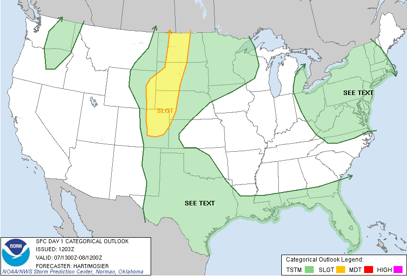
Day 1

Day 2
Bright blue skies in Jackson at this hour with the visible satellite image to back that up...

The Grand Rapids NEXRAD radar is sound asleep with nothing showing on it but ground clutter.
Here's the forecast for Jackson and surrounding communities including Hanover-Horton and Concord:
For today, sunny skies, gentle breezes and pleasant, perhaps the chance of a stray shower or a hit and run thunderstorm in the evening, high 80. Winds N 5-10 MPH.
Tonight, clear skies, cool, low of 51, winds turning westerly 3-8 MPH.
Friday, sunny skies, warmer, nice. High 81, winds W 8-15 MPH.
Friday night, mostly starry skies with a few passing clouds and a low down to 58, winds SW 6-12 MPH.
Saturday, periods of clouds and sunshine, warmer still with a high of 84.
Sunday, partly sunny, breezy and warm, a chance of an isolated afternoon or evening shower or roaming thunderstorm, high 86.
Monday, variably cloudy skies persist, still the chance of an isolated or widely scattered shower, high 87.
Tuesday, cloudy, a chance of scattered showers and thunderstorms, not quite as warm, high 82.
There's a look at your forecast for Jackson for the next six days, I do hope you have a great Thursday! Blessings.
No comments:
Post a Comment