Saturday, December 15, 2012

Quick Look At Tonight...And Sunday...

Good Evening!

A rainy and cooler day in the area, rain is gone for now, some clouds stick around, and a chance at some showers again tomorrow.  Here's the forecast:


Have a great evening!

God Bless Newtown, CT

I was busy yesterday with work and such, and had planned to give you a quick look forecast - until I heard about the horrific tragedy in Newtown, CT yesterday.  I was too shaken to write.  I had to step outside of work for some air as I read the details coming across on CNN.com.  Allow me to vent briefly if you will please.

Yesterday, 20 innocent children were murdered at the hands of a young adult that got into their Connecticut school and began shooting.  When the dust settled, the shooter, along with the kids and six other adults, was dead.  When I picked up my soon to be nine year-old little girl from her third-grade class yesterday afternoon here in Michigan at dismissal, you can bet that I hugged her very tightly and told her how much her mom and I loved her as I drove her back to her mom.

While driving, I silently gave a brief prayer of thanks that I didn't get an emergency phone call like the one that went out to the families of kids attending Sandy Hook Elementary.  I am so very thankful and happy that my daughter, in all likelihood, will be able to celebrate her 8th Christmas as a happy and healthy, rambunctious little lady.

However, my joy is tempered by the fact that a small southern New England town of about 27,000 people will now have a Christmas far different than the one they had envisioned as dawn broke on December 14th.  I am sure that many of the families who lost their precious children or loved ones probably had Christmas shopping for them already done, or had planned to put the finishing touches on that this weekend.  Rather than pulling together plans for Christmas vacation, and Christmas morning celebrations, 27 families and a town, indeed a nation, now have a different type of Christmas mourning to work with.  

We'll never know what 20 young kids would have become with time, growth, and nurturing.  We'll never know how many more lives the adults that died to protect them in that school building would have been able to shape and influence.  We may never know why all this happened.  I certainly hope that's not the case, but it is possible.

In time, our questions will hopefully be answered; our grief, sorrow, and anger will hopefully subside.  In their place, I hope, comes a resolve to make it as difficult as possible for something like this to ever happen again  in our country.  I don't know what that looks like, or the steps needed to make that happen.  I just know, that as a parent and a human being, it needs to happen.  Period.

Tomorrow is a day of rest and worship for a sizable chunk of our nation.  As we get into tomorrow, and during the run-up to Christmas, when most of us will celebrate the birth of Jesus Christ, please say a prayer for those touched by this senseless killing.  Please, in whatever manner and tradition you're used to, pray for the community of Newtown, for comfort during their hours of grief; for grace, to eventually accept what has occurred; and for strength, to move forward, unified, and to care for those still here.

I speak only for myself here, but I sincerely believe that God has added 26 angels to the roster.  I am sure that as time progresses they will be able to do greatness far beyond comprehension.  Thanks for reading, and God Bless Newtown, and the United States Of America.

- Forecaster Mike Estwick


Thursday, December 13, 2012

Quick Look For Thursday...

Good Morning!

Another mild December day is in store for us here in South Central Michigan.  We'll see another day with lots of sun and temperatures nearly 10 degrees above average for this time of the year!  Here's my forecast for today:


I hope that you have a great Thursday!

Wednesday, December 12, 2012

Quick Look For Hump Day...

Good Morning!

Let's get this out of the way first.  I'm calling a forecast bust on myself for last night's forecast, because I was not able to get back onto the blog and change it.  I did mention in yesterday's discussion that it would likely need changing, but it didn't happen.  Bad on me.  We had a starry, cold night last night.

We wake to clear skies and chilly conditions here in south central Michigan this morning, and we can expect a gorgeous day.  Here's my forecast for today:


Keep a blanket close by or a log for the fireplace tonight.  It will be chilly with the wind and no clouds to keep the daytime heat from escaping back into the atmosphere overnight.  Have a great day!

Tuesday, December 11, 2012

A Dusting, Then Quiet...

Hello Again!

If you were hoping that we would somehow not have snow and miss a White Christmas, well...the no snow bit is out the window.  Still far too early to predict a White Christmas with any accuracy.  We picked up about a tenth of an inch this morning here in Jackson as some lake effect snow managed to hold shape long enough to dust us.  Right now the sun has broken through and offered himself for view.  Still plenty chilly here and in a good part of the US, here's the surface temperature plot for your viewing pleasure:


Now, let's take a look and see what we have running under the hood here...

SUMMARY:  Fairly calm in the area today, but some lake-effect snow that has been going on since last night continues off to the west.  Berrien County was under advisory for 2-4" of snow into this morning, all due to lake effect.  A couple of upper disturbances are nearby, one of which is touching off some snow in far western Wisconsin at this hour.  I don't see that impacting south central Michigan.  More good news in that the lake effect snow should soon be tapering off and leaving just a mix of clouds and sunshine for today, helping us melt most of this snow that we picked up this morning.  The quick look forecast said cloudy with flurries tonight; I am leaving it as is for the moment, though improvement looks possible, into a deal where we'll see some breaks for stars in the sky after dark.  Looking ahead, we see clearing and temperatures working up to 40 degrees plus over the next few days, with high pressure locking into the area and bringing us fair skies.

PRECIPITATION:  Not much to talk about regarding precipitation for the rest of the workweek.  As I mentioned above, Canadian high pressure is settling in over the area, though thankfully, not the bitterly cold variety that has kept our friends out in the Plains and Rockies in the freezer.  As a result, not much to kick off any rain or snow events.  If we do get any snow, it will be from a passing upper wave, and I would daresay that would show as some lake effect that holds together long enough to make it well inland.  Unlikely though it is, anything we get here from that kind of a deal should stay at an inch or less.  Here's what the National Weather Service thinks regarding precipitation totals the next five days:

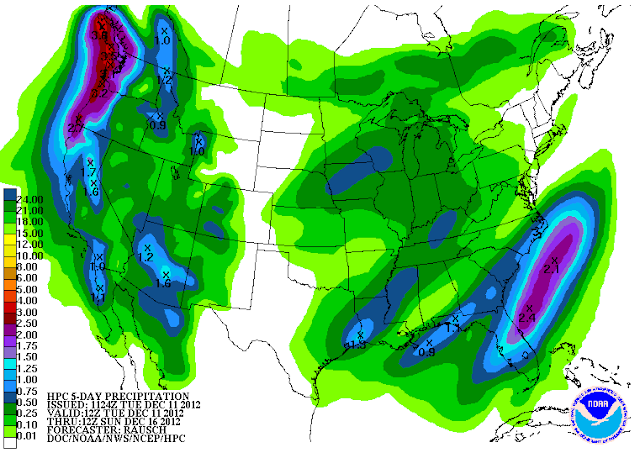
5 Day Precipitation Forecast
WEEKEND RAIN?:  Looking into the weekend, one of our friendly computer models, the Global Forecast System (GFS), is suggesting to me that a surface low will be making tracks for our part of the world late this week.  The low generates some scattered showers around lunchtime Saturday, these becoming more numerous as the afternoon wears on.  We keep all of that around Saturday night and into Sunday, then start tapering it off early Sunday afternoon.  It should be mostly gone in time for the drive to work on Monday morning.  Temperatures will fall off from Saturday a bit, so as this stuff leaves on Sunday if the GFS has it right, a snow shower or two isn't out of the question.

Right now we don't have much going on, the snow is lifting northeast and out of here.  Just a little bit of snow lingering in Eaton, Ingham, and Clinton counties in the north zone of the blog:

Grand Rapids NEXRAD Radar, in precipitation type mode
Here's the forecast for Jackson and surrounding areas including Grass Lake and Sandstone Township:

Today, periods of clouds with a few peeks of sun, some flurries or even light snow are possible, high 34.  Wind SW 3-6 MPH.

Tonight, a few lingering flurries with some late clearing, lows near 23, SW winds 5-10 MPH will put wind chills into the teens.

Wednesday, partly sunny, a bit warmer, high 40.  Wind SSW 5-10 MPH.

Wednesday night, mostly starry skies, seasonably chilly, lows near 24, winds SW 7-14 MPH.

Thursday, sunshine early, may just a few clouds develop in the afternoon, milder, highs warm back up to 42.

Friday, mainly sunny,  some clouds start to roll in during the evening, continued mild, high 41.

Saturday, increasingly cloudy skies, scattered lunchtime showers become more numerous as the afternoon progresses, high 40.

Sunday, cooler temperatures under cloudy skies may create a rain/snow mix as precipitation tapers off after lunch.  High 38.

Monday, cloudy skies to start the work week, a few scattered rain or snow showers can't be ruled out, cooler, high only 36.

There's a look at you six day forecast, I do hope that you have a great Tuesday!  Blessings.

Quick Look At Tuesday

Good Morning!

We awakened to some snow flurries that have developed into some light snow here in south central Michigan this morning!  We'll keep it around for awhile this morning with some tapering off to flurries as the day progresses.  Here's my forecast for today!


I hope you have a great Tuesday!

Monday, December 10, 2012

Quick Look For Monday

Good Morning!

Cloudy and gray here today with some light showers, maybe some freezing stuff later today.  Wild weather in the Deep South, as Mississippi woke to the sound of tornado warnings blaring from TV's and radios there as this cold air sweeps into the US.  Here's a look at the forecast for today closer to home:


I hope you have a great Monday!

This Should Have Been Up Yesterday

(Disclaimer:  This forecast was done on Saturday night, and should have gone up at that point in time.  Instead it didn't and I was off the grid yesterday. - Forecaster Mike)

Good Evening!

There are a few changes on the horizon here and elsewhere in the nation.  An Arctic Express invades the US from north of the border, and frigid temperatures settle into the nation's midsection, along with some heavy-duty snowfall.  The good news?  Michigan gets spared a lot of headache this go-round.  Time to pop the hood and have a look...

SUMMARY:  A good chunk of the nation's middle third gets shoved into the fridge or freezer as Old Man Winter makes his presence known, especially in the Dakotas and Minnesota.  Temperatures Monday and into Tuesday could stay below 15 degrees in the northern tier of states, from Montana to Wisconsin, with those frigid readings maybe grazing the western Upper Peninsula of Michigan.  Cold air invades in force, sending temperatures for much of the nation plummeting.  The good news: daytime highs here stay in the 35-41 range over the next several days. This sounds cold compared to what we have had, but it is actually very seasonable.  Highs this time of year should be about 35, no more.  Now that we've set the table somewhat, with all the cold air and some moisture around, we'll talk about every forecaster's winter headache...

PRECIPITATION:  I was actually surprised to see some snow in the north zone of the blog that stuck to the pavement today, even if only briefly.  Clinton County picked up 1.5 inches of snow today!  We won't have to worry about brevity of snow sticking around for much longer, as we get deeper into December and the winter season, temperatures come down enough and solar heating wanes enough that if it falls, it sticks, either as snow or ice.  Thankfully, temperatures stay far enough above freezing that we shouldn't get any significant accumulations out of freezing precipitation.  That being said, counties on the west end of the forecast zones should keep an eye out for lake effect snow over the next few days.

The NWS thinks we come in at a quarter inch tops, and that doesn't look out of line to me.  Most places shouldn't pick up much of anything at all, and those that do see something falling should see it as rain initially, but I do think we get involved with a wintry mix tomorrow late and into Monday.  So far, I still like the whole little or no accumulation idea, but we'll need to revisit that later.  Right now, it looks like we start to see some rain after lunchtime, and as temperatures come down, some mixing into a touch of snow looks likely.

Let's take a look at the forecast for Jackson and surrounding areas including Leslie and Concord:

Tonight, we remove the mention of precipitation in the guise of a rain and snow mix, and just leave it cloudy and cold, lows near 29.  Wind NE 7-12 MPH.

Tomorrow, cloudy, seasonably cool, scattered to numerous showers should arrive around lunchtime and persist in periods through the day, high 40.  Winds becoming WSW 6-12 MPH.

Sunday night, still cloudy, a few snowflakes may mix in before everything starts to taper off after dinnertime, lows roll back to 33, winds W 7-12 MPH.

Monday, continued cloudy, just the mention of a possible stray shower or flurry, high only 38.  Wind turning N 5-10 MPH.

Monday night, cloudy skies and cold, lows dip all the way down to 24, winds NW 5-10 MPH, wind chills will dip near single digits.

Tuesday, periods of clouds with a few peeks of sun, colder, high 35.

Wednesday, continued partly sunny, a touch warmer, high 36.

Thursday, sunshine early, increasing clouds during the afternoon, milder, highs warm back up to 41.

Friday, a mix of clouds and sunshine, a lone shower or flurry can't be ruled out, high 40.

Saturday, cloudy skies, a chance of a few showers, high 43.

There's a look at your forecast for the next six days, I do hope that you have a great evening!  Blessings.