Good Morning!
A beautiful day on tap for South Central Michigan today with sunny skies and seasonable temperatures, but then tomorrow, scattered to numerous showers and thunderstorms look to move in, and some of those could be elevated, which means they'll blow hard and possibly drop some small hail. Let's take a look and see what we have.
TEMPERATURES: We'll see temperatures right around where they should be for the weekend, but then they take a bit of a nosedive on Monday, as the upper air pattern brings us a good shot of cool air from up in Canada. Temperatures look to run about 10 degrees cooler for Monday into Tuesday, with computer modeling suggesting daytime highs in the 70's for Monday and Tuesday. After that, we get back into the summer-like middle 80's that are more the norm for this time of year.
RAIN: The rain forecast looks like a twin-barreled event, with one shot early Sunday morning, then a better chance late Sunday afternoon or evening. For my money, I'm inclined to hang my hat on the evening event as the better of the two. I am forecasting isolated to widely scattered for the early chance, then for the afternoon and evening the coverage should be a little more widespread, so I will call it scattered. After that, we stay pretty dry until the end of the month, when we have our next best chance at rain.
SEVERE WEATHER: While the Storm Prediction Center doesn't have us with anything severe, for Sunday, they do introduce some low end 5% chances for rough weather, with the primary threat being elevated storms with strong straight-line winds and perhaps some small hail. You can thank a cold front coming down the back side of the big ridge in the central part of the nation for that. Out ahead of it in an air mass with temperatures in the 80's, some storms are expected to fire. We'll have to see what kind of unstable they can get hold to, as that determines how strong they'll become.
Bright blue skies in Jackson right now with variable winds, here's the local forecast for Jackson and surrounding communities including Grass Lake and Parma:
Today, mainly sunny, maybe a couple of passing clouds, high 81, variable winds up to 6 MPH.
Tonight, partly cloudy skies, a bit milder than Friday night, lows roll back to 58, winds SW calm to 5 MPH.
Sunday, partly sunny skies, a chance of a widely scattered afternoon shower or pop-up thunderstorm, high 83. Winds SW 7-14 MPH.
Sunday night, continued periods of clouds and stars, chance of a scattered shower or storm, lows down to 53, winds swing to the NE 5-10 MPH.
Monday, sunny, much cooler, pleasant, high 74.
Tuesday, mainly sunny, seasonable and nice, high 77.
Wednesday, a rewind and repeat of Tuesday. Sunny and pleasant with a high of 78.
Thursday, periods of clouds and sunshine, warm, high 86.
There's a look at your forecast for the next six days, I do hope you have a great Saturday! Blessings!
Saturday, June 23, 2012
Friday, June 22, 2012
Quick Update...A Small Chance Of Rain...
Good Evening Friends!
Just had a rare early evening chance to look at some data and radar, and I see enough to change the forecast slightly for tonight. What we've got now is a couple of rogue thunderstorms firing out over Lake Michigan, and some small showers further inland and tracking southwest. Right now the smaller stuff is currently in west Michigan, and it looks as if they are falling apart as they move deeper over land and into the drier air, but here in the blog zone, we may see a couple of stragglers that manage to form up and fire briefly later on.
Your updated forecast for tonight is partly cloudy skies, we'll add in a chance of an isolated or widely scattered shower, perhaps a lonely thunderstorm, nighttime low of 53 with NW winds 5-10 MPH.
More on this tomorrow, but computer forecast modeling indicates we may have a crack at some showers before daybreak again on Sunday, then perhaps a more substantial threat late Sunday night into Monday. That will depend on how close an upper disturbance tracks to us as it slides off the back of the ridge that will keep the Plains hot and high ninety-ish for the next few days. We'll check it out and forecast it for you tomorrow! Have a great evening! Blessings.
Strong Wind Shift Advisory - Livingston, Washtenaw
The National Weather Service has issued a Special Weather Statement for a strong wind shift for Livingston and Washtenaw Counties. Winds over 30MPH are moving in from northwest to southeast, and may cause small objects to be blown around, so secure anything you don't want blown away.
Nice Weekend In The Works...
Good Morning!
TGIF! We've almost made it through another work week, and the weekend is creeping closer by the minute! It looks to be a pretty nice one once we get through today and a tiny lingering shower threat. Let's take a deeper dive and see what we have on tap...
TEMPERATURES: With a trough-ridge-trough pattern starting to emerge over the US, we'll see temperatures much more moderate as compared to recent days. Humidity will be down some as well, with drier air working into the area. Temperatures will top out at around 84 degrees for a few days, then late next week, we'll see winds shift and come in more directly from the west as opposed to making a detour up through Canada and coming in from the northwest.
RAIN: The dryness continues over South Central Michigan for the next few days, as we really don't pick up much of anything according to the National Weather Service for the next five days. Considering that we don't really have any weather systems poised to pay us a visit the next few days, this 5 day precipitation map from the NWS looks like a good bet from here:
As you can see, basically nothing in the forecast, perhaps a brief stray shower but that's about it.
SEVERE WEATHER: The Storm Prediction Center doesn't expect much in the way of severe weather for us for the weekend, which is a good thing. We've got a "general" risk just north of us for today, so I need to mention that a rogue thunderstorm or two may fire and cruise through, but anything that does happen, shower or storm, will be isolated. Day three, SPC has us in a 5% chance for severe weather, so we'll need to keep an eye on it. Here's the forecast maps for days one and three, valid at 8AM EDT as always.
Nothing on the infrared satellite image this morning, and the Grand Rapids NEXRAD is quiet, those heavier green returns you see are ground clutter and some dense fog that is lingering in the area.
Here's the local forecast for Jackson County:
Today, mostly sunny skies with a couple of passing clouds, high of 80, winds NNW 5-10 MPH.
Tonight, mainly starry skies with a lone cloud or two floating by, low 54, winds NNW 3-8 MPH.
Saturday, mainly sunny, perhaps a few clouds, high 81, variable winds up to 6 MPH.
Saturday night, a mix of clouds and stars, a bit warmer than Friday night, low of 58, winds SW calm to 5 MPH.
Sunday, partly sunny skies, a slight chance of an isolated or widely scattered afternoon shower or pop-up thunderstorm, high 83.
Monday, sunny, much cooler, pleasant, high 74.
Tuesday, mainly sunny, seasonable and nice, high 77.
Wednesday, a rewind and repeat of Tuesday. Sunny and pleasant with a high of 78.
There's a look at your forecast for the next six days, I do hope you have a great Friday and a wonderful weekend! Blessings.
TGIF! We've almost made it through another work week, and the weekend is creeping closer by the minute! It looks to be a pretty nice one once we get through today and a tiny lingering shower threat. Let's take a deeper dive and see what we have on tap...
TEMPERATURES: With a trough-ridge-trough pattern starting to emerge over the US, we'll see temperatures much more moderate as compared to recent days. Humidity will be down some as well, with drier air working into the area. Temperatures will top out at around 84 degrees for a few days, then late next week, we'll see winds shift and come in more directly from the west as opposed to making a detour up through Canada and coming in from the northwest.
RAIN: The dryness continues over South Central Michigan for the next few days, as we really don't pick up much of anything according to the National Weather Service for the next five days. Considering that we don't really have any weather systems poised to pay us a visit the next few days, this 5 day precipitation map from the NWS looks like a good bet from here:
 |
| 5 Day Precipitation Forecast |
SEVERE WEATHER: The Storm Prediction Center doesn't expect much in the way of severe weather for us for the weekend, which is a good thing. We've got a "general" risk just north of us for today, so I need to mention that a rogue thunderstorm or two may fire and cruise through, but anything that does happen, shower or storm, will be isolated. Day three, SPC has us in a 5% chance for severe weather, so we'll need to keep an eye on it. Here's the forecast maps for days one and three, valid at 8AM EDT as always.
 |
| SPC Forecast Map, Day 1 |
 |
| SPC Forecast Map, Day 3 |
 |
| Grand Rapids (GRR) NEXRAD Radar, showing some fog in northern Hillsdale County. |
Today, mostly sunny skies with a couple of passing clouds, high of 80, winds NNW 5-10 MPH.
Tonight, mainly starry skies with a lone cloud or two floating by, low 54, winds NNW 3-8 MPH.
Saturday, mainly sunny, perhaps a few clouds, high 81, variable winds up to 6 MPH.
Saturday night, a mix of clouds and stars, a bit warmer than Friday night, low of 58, winds SW calm to 5 MPH.
Sunday, partly sunny skies, a slight chance of an isolated or widely scattered afternoon shower or pop-up thunderstorm, high 83.
Monday, sunny, much cooler, pleasant, high 74.
Tuesday, mainly sunny, seasonable and nice, high 77.
Wednesday, a rewind and repeat of Tuesday. Sunny and pleasant with a high of 78.
There's a look at your forecast for the next six days, I do hope you have a great Friday and a wonderful weekend! Blessings.
Thursday, June 21, 2012
Cooling Down...Coming Soon...
Good Afternoon!
We have made it though a hot day yesterday and a warm morning today. It looks like relief is finally on the way, in the form of a cold front that is kicking off some showers and thunderstorms ahead of it. On the backside of that, we should see temperatures retreat for the next couple of days. Let's take a peek and see what's going on this first full day of summer...
TEMPERATURES: Temperatures roll back on the cool side of the front as it moves through the area. Drier Canadian air holds temperatures right around the 80 degree mark for the next few days, and humidity values come down as well. A bigger cool down is on tap next week, with temperatures topping out in the low to middle 70's if things play out as advertised according to computer modeling! In fact, the GFS computer model likes a high temperature of 72 for Monday!
RAIN: We have a chance at some scattered showers and perhaps a roaming thunderstorm today as the cold front and associated low move through the area. After that, not much for the next few days, so again, we will still be way behind what we need as far as monthly rainfall. The National Weather Service is thinking we pick up between a quarter to a half-inch of rain the next five days, which we may, but it will be scattered and hit or miss, and not very uniform in nature. A good, uniform, soaking rain would help a bunch right now! Here's the 5 day precipitation map from the National Weather Service...
SEVERE WEATHER: Not much of that here in the area for the next three days according to the Storm Prediction Center. In fact, today is the only day that we have anything on the map to deal with, and that's just a low end 5% chance for storms with damaging straight line winds. This is the first time in a while that the whole of Michigan, both peninsulas, will be fairly quiet as far as severe weather is concerned. Here's the maps for days one and two with their "general" risk areas outlined...
Here's a look at the visible satellite at this hour, and the scattered showers and storms on the Grand Rapids NEXRAD radar.
Here's the forecast for Jackson County:
For the rest of today, mixed clouds and sunshine, a chance of an isolated or widely scattered shower or a rogue thunderstorm, high temperature 85, winds W 7-14 MPH.
Tonight, variably cloudy skies with perhaps a stray shower early, then some peeks at stars, much cooler, lows drop to 59, NNW winds 5-10 MPH.
Friday, partly cloudy skies, not as warm as Thursday, with a high of 81, winds NNW 5-10 MPH.
Friday night, clearing skies, cooler, lows drop to 55, winds NNW 3-8 MPH.
Saturday, mainly sunny, maybe a few clouds, high 81.
Sunday, partly sunny, a slight chance of an isolated or widely scattered afternoon shower or pop-up thunderstorm, high 80.
Monday, more clouds than sun, very cool, high only 72.
Tuesday, mainly sunny, still unseasonably cool, high 73.
There's a look at your forecast for the next six days, I do hope you have a great rest of your Thursday! Blessings.
We have made it though a hot day yesterday and a warm morning today. It looks like relief is finally on the way, in the form of a cold front that is kicking off some showers and thunderstorms ahead of it. On the backside of that, we should see temperatures retreat for the next couple of days. Let's take a peek and see what's going on this first full day of summer...
TEMPERATURES: Temperatures roll back on the cool side of the front as it moves through the area. Drier Canadian air holds temperatures right around the 80 degree mark for the next few days, and humidity values come down as well. A bigger cool down is on tap next week, with temperatures topping out in the low to middle 70's if things play out as advertised according to computer modeling! In fact, the GFS computer model likes a high temperature of 72 for Monday!
RAIN: We have a chance at some scattered showers and perhaps a roaming thunderstorm today as the cold front and associated low move through the area. After that, not much for the next few days, so again, we will still be way behind what we need as far as monthly rainfall. The National Weather Service is thinking we pick up between a quarter to a half-inch of rain the next five days, which we may, but it will be scattered and hit or miss, and not very uniform in nature. A good, uniform, soaking rain would help a bunch right now! Here's the 5 day precipitation map from the National Weather Service...
 |
| 5 Day Precipitation Forecast |
SEVERE WEATHER: Not much of that here in the area for the next three days according to the Storm Prediction Center. In fact, today is the only day that we have anything on the map to deal with, and that's just a low end 5% chance for storms with damaging straight line winds. This is the first time in a while that the whole of Michigan, both peninsulas, will be fairly quiet as far as severe weather is concerned. Here's the maps for days one and two with their "general" risk areas outlined...
 |
| Day 1 Severe Outlook |
 |
| Day 2 Severe Outlook |
Here's a look at the visible satellite at this hour, and the scattered showers and storms on the Grand Rapids NEXRAD radar.
 |
| Visible Satellite Image |
 |
| Grand Rapids (GRR) NEXRAD Radar Reflectivity Image |
For the rest of today, mixed clouds and sunshine, a chance of an isolated or widely scattered shower or a rogue thunderstorm, high temperature 85, winds W 7-14 MPH.
Tonight, variably cloudy skies with perhaps a stray shower early, then some peeks at stars, much cooler, lows drop to 59, NNW winds 5-10 MPH.
Friday, partly cloudy skies, not as warm as Thursday, with a high of 81, winds NNW 5-10 MPH.
Friday night, clearing skies, cooler, lows drop to 55, winds NNW 3-8 MPH.
Saturday, mainly sunny, maybe a few clouds, high 81.
Sunday, partly sunny, a slight chance of an isolated or widely scattered afternoon shower or pop-up thunderstorm, high 80.
Monday, more clouds than sun, very cool, high only 72.
Tuesday, mainly sunny, still unseasonably cool, high 73.
There's a look at your forecast for the next six days, I do hope you have a great rest of your Thursday! Blessings.
Wednesday, June 20, 2012
Hot Again, Some Relief In Sight....
Good Morning!
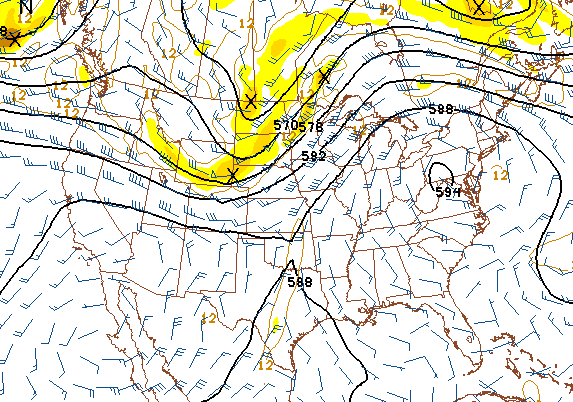
One of the hottest days of the year is here, but some form of relief is on tap for us for in another day or two. A pair of 588 heat domes have set up shop in the southwest and southeast parts of the nation, joined forces through the deep south and southern Plains, and are making their presence known with temperatures in the middle 90's all the way up into New England! Here's a map from the GFS computer forecast model. Where the 588 lines are is where the heat is. There's also a 594 circle in southwestern PA and the Virginias, that's good for intense heat, with air temperatures likely exceeding 100+!
If you have to be outside in the South Central Michigan Weather Zone today, rest often, drink lots of water, and shade it up as much as practical! It is an Ozone Action Day for Lenawee, Washtenaw and Livingston counties today as well, so those of you in those areas REALLY need to take it easy during the day. Let's take a look at what's under the hood...
TEMPERATURES: Can be summed up in one word: HOT! We see temperatures edge as close to 100 as they have all year today, with high temperatures right around 95. Heat index values will easily make it into the triple digits, against dew point values of 60 or better, so this heat will be a muggy, uncomfortable kind of heat that saps your energy if you are outside. It's already warm around the area, with most spots in the blog area already reporting temperatures pushing 80 degrees before 9AM! Here's a look at temperatures around the US right now...
RAIN: We'll stay in the sprinklers needed regime. The National Weather Service is suggesting a pretty dry five day stretch for us here in South Central Michigan, with any one point around here not expected to pick up much more than a quarter inch of rain! We are far behind where we should be for the month and season so far, and the temporary refresh from the line of thunderstorms that moved through Monday is long gone. It looks like some areas may score a little bit of badly needed rain on Thursday, as the upper trough that has been raining on MN and WI finally gets close enough to us to perhaps touch off a shower or two. Here's a look at the forecast map for the next five days...
SEVERE WEATHER: Nothing in Lower Michigan for the next three days at this point. The Storm Prediction Center has the Upper Peninsula in a "slight" risk area, and a "general" risk for a sliver of the Lower Peninsula today. Now, there is a trough moving this way west of us, and that is what's causing the severe threat I just mentioned. Tomorrow there is just a small 5% threat of severe weather in our area, largely confined to the southeast part of the state. Here's those maps from SPC...
Not much going on at this hour in the area, the visible satellite image shows us mainly clear with just a few passing clouds, but you can see where the upper trough is right now that will kick off some showers and thunderstorms. Grand Rapids NEXRAD is quiet.
Here's the forecast for Jackson and surrounding communities including Liberty Township and Grass Lake:
For today mainly clear skies with perhaps a passing cloud or two, hot, high temperature 94, heat index values at or above 100. SW winds 7-14 MPH.
Tonight, mostly starry skies, again a few clouds may float by, still warm, nighttime lows only roll back to 68, winds start SW but turn NW 6-12 MPH.
Thursday, a mix of clouds and sunshine, perhaps the chance of an isolated or widely scattered shower or a rogue thunderstorm, cooler, high temperature 85, winds W 7-14 MPH.
Thursday night, some clouds and stars mix, much cooler, nighttime lows drop to 59, NNW winds 5-10 MPH.
Friday, variably cloudy skies, cooling a bit more, with a high of 81.
Saturday, continued periods of clouds and sunshine, high 81.
Sunday, partly sunny, a slight chance of an isolated or widely scattered afternoon shower or pop-up thunderstorm, high 83.
Monday, clear skies, comfortable, high 79.
There's a look at your forecast for the next six days, I do hope your hump day Wednesday is a great one! Blessings.
One of the hottest days of the year is here, but some form of relief is on tap for us for in another day or two. A pair of 588 heat domes have set up shop in the southwest and southeast parts of the nation, joined forces through the deep south and southern Plains, and are making their presence known with temperatures in the middle 90's all the way up into New England! Here's a map from the GFS computer forecast model. Where the 588 lines are is where the heat is. There's also a 594 circle in southwestern PA and the Virginias, that's good for intense heat, with air temperatures likely exceeding 100+!
 |
| GFS Computer Forecast Model Map, 500mb Thickness and Vorticity |
TEMPERATURES: Can be summed up in one word: HOT! We see temperatures edge as close to 100 as they have all year today, with high temperatures right around 95. Heat index values will easily make it into the triple digits, against dew point values of 60 or better, so this heat will be a muggy, uncomfortable kind of heat that saps your energy if you are outside. It's already warm around the area, with most spots in the blog area already reporting temperatures pushing 80 degrees before 9AM! Here's a look at temperatures around the US right now...
 |
| US Surface Temperature Reports, 9:00AM EDT |
 |
| National Weather Service 5 Day Precipitation Forecast |
 |
| SPC Day 1 Severe Outlook |
 |
| SPC Day 2 Severe Outlook |
 |
| Visible Satellite Image |
For today mainly clear skies with perhaps a passing cloud or two, hot, high temperature 94, heat index values at or above 100. SW winds 7-14 MPH.
Tonight, mostly starry skies, again a few clouds may float by, still warm, nighttime lows only roll back to 68, winds start SW but turn NW 6-12 MPH.
Thursday, a mix of clouds and sunshine, perhaps the chance of an isolated or widely scattered shower or a rogue thunderstorm, cooler, high temperature 85, winds W 7-14 MPH.
Thursday night, some clouds and stars mix, much cooler, nighttime lows drop to 59, NNW winds 5-10 MPH.
Friday, variably cloudy skies, cooling a bit more, with a high of 81.
Saturday, continued periods of clouds and sunshine, high 81.
Sunday, partly sunny, a slight chance of an isolated or widely scattered afternoon shower or pop-up thunderstorm, high 83.
Monday, clear skies, comfortable, high 79.
There's a look at your forecast for the next six days, I do hope your hump day Wednesday is a great one! Blessings.
Tuesday, June 19, 2012
Getting Hot Under The Collar!!!
Good Morning!
Another hectic morning, so we'll get right into the deeper dive today!
TEMPERATURES: The heat is ON honey! Temperatures in the low to mid 90's and heat index values near or into triple digits will be the rule of the day for the next couple. A couple of big 588 heat domes have parked themselves over the southwest and southeast parts of the US, and that heat is reaching well north. Hot weather with not much in the way of rain to cool things, other than your typical pop-up thunderstorm. Remember the Vernal Equinox, which was the 1st day of Spring and how cool it was? You won't have any issues knowing it's the first day of summer, that's for sure! After that, we cool into the low 80's in time for the weekend.
RAIN: The half inch or so of rain we picked up in Jackson was welcomed, even though it busted my forecast all to smithereens. I wasn't thinking we'd have an MCS (an unruly mob of thunderstorms) until later in the day, and we got it at the tail end of lunchtime! At any rate, we're back into the sparse rain regime for the next several days, with most areas of Lower Michigan picking up maybe a quarter inch tops. Wisconsin is hogging all the good soaking storm activity! Thursday looks to be the next real chance of any rain in South Central Michigan, then a smaller chance on Sunday. Turn the sprinklers back on!
SEVERE WEATHER: We don't have any of that to worry about here, after the somewhat sneak attack of the MCS running us down from the north. No real defined risk category for this part of Michigan for the next three days, outside of a 5% risk on day three hidden under a "See Text" on the forecast maps from the Storm Prediction Center. That being said, a rogue storm could fire during the afternoon or evening hours, if any unstable air pockets can get a foothold as they rise and nosh on some moist air. Any storms that do get loose will be wind producers primarily.
Here's the local forecast for Jackson County:
Today, mostly sunny, hot, high of 93, winds SW 5-10 MPH. Heat index values will push or break 100, use caution outside!
Tonight, periods of clouds and stars, mild, low 69, increasing SW winds 7-13 MPH.
Wednesday, a mix of clouds and sunshine, still hot, high 91. SW winds 7-14 MPH.
Wednesday night, mainly clear with some passing clouds, still a warm night with temperatures near 68. Winds change from SW to NW 6-12 MPH.
Thursday, mostly cloudy skies, perhaps a few peeks of sunshine, a chance at scattered showers and thunderstorms later in the day, high 84.
Friday, variably cloudy, perhaps the chance of an isolated shower or lonely thunderstorm, a bit cooler with a high of 81.
Saturday, continued periods of clouds and sunshine with the chance at a shower or storm, high 82.
Sunday, more clouds than sun, a chance at an isolated or widely scattered afternoon shower or pop-up thunderstorm, high 83.
There's a look at your forecast for the next six days, I do hope you have a wonderful Tuesday. Blessings!
Monday, June 18, 2012
Updated Forecast For Jackson & Vicinity...
Good Afternoon!
Strong thunderstorms have moved through the area, cooling things off dramatically and dropping over a half inch of rain the last hour. We'll take that rain. No damage or flooding that I am aware of at this time. Models are showing that we should get back into the middle or upper 80's today, along with a continued risk of severe weather north of us. I don't think we get quite that warm, but the possibility of at least some severe weather should still be there with the afternoon heating destabilizing the atmosphere, though that looks marginal with lower available convective energy values (you need that to kick off strong storms.)
Dew points do remain in the low 60's throughout the area, so there will be moist air around for storms to nosh on and rebuild, we will have to wait and see what happens. Across the lake in Wisconsin and a small part of the U.P., the Storm Prediction Center is saying there's an 80% chance of a weather watch being issued in the next hour.
For the rest of the day in Jackson, we see lingering clouds, a chance of more scattered showers and thunderstorms later today or into the early evening with a high of 82. While I cannot rule out another organized system, for my money, any storms we see will be more cellular in design.
We'll update more as needed here, on Twitter, and Facebook.
We'll update more as needed here, on Twitter, and Facebook.
Strong Storms Moving Thru Ingham, Livingston, Jackson, and Washtenaw Counties
Here's the latest Detroit NEXRAD radar image showing the MCS (Mesoscale Convective System) moving southeast...it's starting to look less organized and more cellular as it travels, it should continue to weaken into a mob of cellular storms.
 |
| Detroit NEXRAD Radar |
Storms are strong but NOT severe,lots of rain, some lightning, and wind. Temperatures 10-15 degrees lower due to rain-cooled air on the back side of the storms. After this moves through, we should see temperatures recover into the upper 70's before perhaps another round of storms this evening.
Strong Storms On The Way...Special Weather Statement, Calhoun, Jackson, Eaton, Ingham, Livingston
Good Morning Again

If you've not already done so and had your chance, strong thunderstorms with downpours and gusty winds are on the way through all but the bottom tier of south zone counties in the blog area! Calhoun, Eaton, Ingham, and Livingston have them in progress right now, Jackson and Washtenaw will be getting yours in the next hour. Temperatures are running as much as 15 degrees cooler on the back side of this line of storms. Here's the current Detroit NEXRAD radar image, as you tend to get a better look at storms coming at you as opposed to moving away...

Special Weather Statements are up for strong storms, Calhoun, Jackson, Ingham, Eaton, Livingston Counties...no warnings issued at this time. Follow me @wxMikeD on Twitter or Forecaster Mike Estwick on Facebook for more updates!
Sunny, Summery, Hot...Maybe A Storm...
Good Morning!
I hope all of you dads out there had a great Father's Day! We were able to get the races in on the scheduled days here in Michigan at Michigan International Speedway in Brooklyn. Now that the races have moved on until August, and I am back in town, we are in the regular routine again. Clear skies today, and for the next couple from the looks of it, but things are heating up again temperature-wise. Let's have a closer look.
TEMPERATURES: A very warm day today with temperatures climbing into the middle 80's for the afternoon. After that, we visit and remain in the 90's for awhile, as computer models show us under a heat dome, with high pressure is centered in the southeastern part of the US. It's a typical summer pattern, a strong high parking down in the southeast, spreading out and warming things, you also get showers and thunderstorms on the edges of the high, as well as in other parts of the nation where systems can move about more freely. We'll stay at 85 or better until near the end of the week, when we cool down a little as a front moves through. The cool-off stays with us for a couple of days, then we warm right back up, as the heat dome rebuilds.
RAIN: The showers that delayed the Sunday race at MIS were welcome, though it annoyed the NASCAR fans. While helpful, it was nowhere near enough to green things back up for us, and we are still way behind on rain totals for the month and the season in this part of Michigan. Things aren't forecast to get much better around here rain-wise either, as the 5 Day Outlook from the National Weather Service has us below a quarter inch of rain again for the next five days. Here's that map for you:
That being said, scattered showers and thunderstorms are a possibility in the area as the afternoon progresses, more on that below. After today, it looks like Thursday is the next best chance at picking up some badly needed rain.
SEVERE WEATHER: The Storm Prediction Center has us in a "general" risk for thunderstorms, but there is a "slight" risk area for the northern half of the Lower Peninsula and pretty much all of the Upper Peninsula today. A strong thunderstorm complex is moving out of Wisconsin into Michigan now, currently over the lake, so I would not at all be surprised to see severe weather warnings pop up for counties in the northern part of Lower Michigan later this morning. Here in South Central Michigan, any storms we get could become strong, with a small chance at severe. Here's a look at the forecast maps from the SPC, valid as always at 8AM EDT each day:
Here's a look at the Grand Rapids NEXRAD radar showing those strong storms moving through well to the north of us, and the visible satellite showing them as well.
Here's your forecast for Jackson and surrounding communities including Parma and Grass Lake.
For today, mainly sunny and warm with a few passing clouds, breezy, a chance at an isolated pop-up shower or rogue thunderstorm this evening, high 85, winds SW 8-16 MPH.
Tonight, mostly starry skies with some clouds floating by, mild, nighttime lows only roll back to about 68 with winds SW 6-12 MPH.
Tomorrow, mostly clear skies, hot and summery, high of 91, winds SW 5-10 MPH.
Tomorrow night, continued clear and mild, low 68, increasing SW winds 7-13 MPH.
Wednesday, a mix of clouds and sunshine, still hot, high 90.
Thursday, mostly cloudy skies, perhaps a few peeks of sunshine, a chance at scattered showers and thunderstorms later in the day, high 85.
Friday, variably cloudy, perhaps the chance of an isolated shower or lonely thunderstorm, a bit cooler with a high of 81.
Saturday, continued periods of clouds and sunshine with the chance at a shower or storm, high 82.
There's a look at your forecast for the next six days, I do hope you have a wonderful Monday. Blessings!
I hope all of you dads out there had a great Father's Day! We were able to get the races in on the scheduled days here in Michigan at Michigan International Speedway in Brooklyn. Now that the races have moved on until August, and I am back in town, we are in the regular routine again. Clear skies today, and for the next couple from the looks of it, but things are heating up again temperature-wise. Let's have a closer look.
TEMPERATURES: A very warm day today with temperatures climbing into the middle 80's for the afternoon. After that, we visit and remain in the 90's for awhile, as computer models show us under a heat dome, with high pressure is centered in the southeastern part of the US. It's a typical summer pattern, a strong high parking down in the southeast, spreading out and warming things, you also get showers and thunderstorms on the edges of the high, as well as in other parts of the nation where systems can move about more freely. We'll stay at 85 or better until near the end of the week, when we cool down a little as a front moves through. The cool-off stays with us for a couple of days, then we warm right back up, as the heat dome rebuilds.
RAIN: The showers that delayed the Sunday race at MIS were welcome, though it annoyed the NASCAR fans. While helpful, it was nowhere near enough to green things back up for us, and we are still way behind on rain totals for the month and the season in this part of Michigan. Things aren't forecast to get much better around here rain-wise either, as the 5 Day Outlook from the National Weather Service has us below a quarter inch of rain again for the next five days. Here's that map for you:
 |
| 5 Day Precipitation Forecast |
SEVERE WEATHER: The Storm Prediction Center has us in a "general" risk for thunderstorms, but there is a "slight" risk area for the northern half of the Lower Peninsula and pretty much all of the Upper Peninsula today. A strong thunderstorm complex is moving out of Wisconsin into Michigan now, currently over the lake, so I would not at all be surprised to see severe weather warnings pop up for counties in the northern part of Lower Michigan later this morning. Here in South Central Michigan, any storms we get could become strong, with a small chance at severe. Here's a look at the forecast maps from the SPC, valid as always at 8AM EDT each day:
 |
| SPC Day 1 Severe Outlook |
 |
| SPC Day 2 Severe Outlook |
 |
| SPC Day 3 Severe Outlook |
 |
| Grand Rapids (GRR) NEXRAD Radar |
 |
| Visible Satellite Image |
For today, mainly sunny and warm with a few passing clouds, breezy, a chance at an isolated pop-up shower or rogue thunderstorm this evening, high 85, winds SW 8-16 MPH.
Tonight, mostly starry skies with some clouds floating by, mild, nighttime lows only roll back to about 68 with winds SW 6-12 MPH.
Tomorrow, mostly clear skies, hot and summery, high of 91, winds SW 5-10 MPH.
Tomorrow night, continued clear and mild, low 68, increasing SW winds 7-13 MPH.
Wednesday, a mix of clouds and sunshine, still hot, high 90.
Thursday, mostly cloudy skies, perhaps a few peeks of sunshine, a chance at scattered showers and thunderstorms later in the day, high 85.
Friday, variably cloudy, perhaps the chance of an isolated shower or lonely thunderstorm, a bit cooler with a high of 81.
Saturday, continued periods of clouds and sunshine with the chance at a shower or storm, high 82.
There's a look at your forecast for the next six days, I do hope you have a wonderful Monday. Blessings!
Sunday, June 17, 2012
Hot, Muggy, Some Rain...
Good Afternoon!
After some Father's Day activities with me and the rugrat, I am back home for now and able to write forecasts for you/We have clear skies and muggy conditions around Jackson after some morning showers that ultimately delayed the start of the Quicken Loans 400 at Michigan International Speedway in Brooklyn. As I write this, those showers have moved on eastward, yielding partly sunny skies. The race should be able to be completed without any weather related issues. A few showers and storms moved through the area last night as well. I will be writing the forecast for you now, and the deeper dive will come later.
For the rest of today, periods of clouds and sunshine, high 83, winds SW 5-10 MPH.
Tonight, partly cloudy skies, an outside chance of a shower, low 60, winds S 5-10 MPH.
Tomorrow, a mix of clouds and sunshine, chance of scattered showers and thunderstorms in the afternoon, high 89, winds SW 8-15 MPH.
Tomorrow night, partly starry skies, low 69, winds SW 6-12 MPH.
Tuesday, partly sunny, hot, high 91.
Wednesday, a mix of clouds and sunshine, warm, high 88.
Thursday, partly to mostly cloudy, a chance of scattered showers and thunderstorms, high 85.
Friday, periods of clouds and sunshine, high 84.
We'll have a deeper dive for you later today!
Subscribe to:
Comments (Atom)