Friday, September 18, 2015

Stormy Then Splendid...

Good Morning!

Rain with a few thunderstorms working through the area at this hour as advertised.  We'll see plenty more in the next 36 hours or so, let's take a closer look.

RADAR CHECK:  A line of showers and storms is pushing through Jackson and South Central Michigan at this hour:


This is that lead impulse that I have been discussing with you the last few days.  It will continue to bring some shower and storm activity into the area as it works through.

A BREAK IN THE ACTION FOR MOST SPOTS:  I expect the rains to impact the balance of the morning drive but be working out of here by say, 10 AM.  We'll keep clouds around the area in fits and starts, but I don't think any one area sees continuing rain right through the day.  In fact, some areas will have a bit of sunshine this morning, and all of that is setting the stage for what could happen this afternoon.

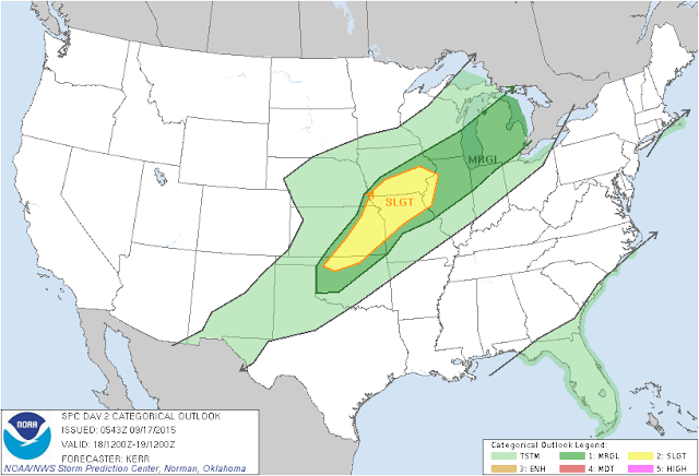
SEVERE WEATHER POSSIBLE LATER:  The folks at the Storm Prediction Center have included pretty much all of Lower Michigan in a risk category for severe weather today.  Thankfully, it's the "marginal" risk as opposed to the "slight" that is present back to the south and west of us.  Here's a look at the maps:

SPC Day 1 Risk
SPC Day 2 Risk
Based on how things are expected to layout, Michigan is too far removed from the quality dynamic support that you need to kick off thunderstorms that are capable of spinning up a tornado.  That being said, expect storms that will have heavy downpours, marginally severe wind, and perhaps a bit of small to marginally severe hail.

REDEVELOPING SHOWERS/STORMS:  The first disturbance is gone for lunchtime.  I expect at least a few peeks of sun this afternoon, then as the more substantial shortwave disturbance and his associated cold front get to us, expect the clouds to increase and some pop-up showers and thunderstorms to fire out ahead of the main system.  Umbrellas are a good thing to have, especially if you're headed out to a high school football game this evening!  That being said, my thought is we should be able to get most of the games or your other outdoor evening plans done tonight without interruption.  Prevailing wisdom from the models suggests that the greater coverage of showers and storms doesn't really arrive until after 9 PM or so, but be prepared in case the second system shows up sooner than expected.  Your student-athletes will probably be close to home by the time the rains start to arrive in earnest.  Have a look at this map of the NAM Model FutureCast.  This is for 6 PM tonight...


One BIG caveat:  What we get tonight and the intensity will be directly correlated to how much sunshine we get across South Central Michigan between events this morning and afternoon.  Clearer skies than expected, plan on more widespread and higher intensity showers and storms.  If it stays cloudier than we think, back the intensity and coverage off a notch,  We'll have to watch it hour by hour.

SATURDAY?:  Pre-dawn showers and thunderstorms.  The good news is if you're headed out for some college football, most games should be be rain-free.  All indications are that the rain should be out of here by noon with clearing and cooler temperatures on the back side of the frontal boundary.

LOOKING DOWN THE LINE:  After this quick double barreled hit today and tomorrow, it stays quiet for awhile.  The next shot at any widespread rain could be early next month!  Forecast model data suggests maybe a shortwave disturbance for early next week, but weak, with no dynamic support to create anything,  After that, our upper air flow stays zonal to flat ridged, with another wave and a disturbance coming through a week from Sunday, or 9/27, but that doesn't look to do much more than maybe cloud us up.

Here's the forecast for Jackson and surrounding areas including Michigan Center and Springport:

Today - AM showers and any storms move off with the disturbance and leave cloudy skies with some breaks for sun.  Clouds redevelop PM, a few stray showers or even a roaming storm can't be ruled out.  High 76.

Tonight - Showers and thunderstorms re-develop, some could be marginally severe with heavy rains, high winds and even some small hail.  Lows near 61.

Saturday - Showers and thunderstorms should be pretty well gone by lunchtime,  Clouds start to thin in the afternoon, high 71.

Sunday - Sunny & seasonable.  High 69.

Monday - Clear & comfortable.  High 70.

Tuesday - Abundant sunshine and pleasant.  High 72.

Wednesday - Rinse & repeat Monday or Tuesday, sunshine and mild.  High 75.

Thursday - Continued clear and pleasant.  High 76.

Friday - Sunshine, nice.  High 75.

There's a look at your forecast.  I hope that you have a great day!  Blessings.

Thursday, September 17, 2015

Details On The Weekend...

Good Evening!

As promised, I'm having a look at the forecast data to try to get some better grasp on what I expect to transpire in the next 24 to 36 hours.

YEP, THOSE SHOWERS ARE STILL THERE:  No question in my mind that we do pick up some showers and thunderstorms in the area.  The solution now seems to be maybe a stray shower or two between say, 8 and midnight, with heavier rains working into the area during the overnight and into early tomorrow morning.  My suspicion is that at least some of the heavier rain will stay north of Lansing.  I can't pinpoint it any more specifically for you then that, as there is still spread in the model solutions as to how hard of a left turn this disturbance makes as it heads up into Canada,  Let's call it a few isolated showers until about 10 PM, then scattered to numerous showers and perhaps a storm after that,  Lows will drop to about 58, a couple or 3 degrees lower where the rains are.

SOME SUNSHINE TOMORROW, THEN MORE RAIN:  Forecast data for tomorrow is suggesting that we do see at least some peeks of sunshine, but I don't see sustained heating that will really juice up the atmosphere with the kind of energy you'd be looking for to get severe weather.  For sure we'll have some scattered showers and storms though, so keep the umbrella with you.  Some of these storms could be strong, or even marginally severe, with high winds and some downpours the primary threat.  Forecast models are discussing the idea of 72 for a high, but I think we back that off to 70.  This temperature forecast could easily bust though, depending on how much sun we see between visits from these systems,  Expect showers and storms back into the area by about 6 PM in scattered fashion, and don't be shocked to see some raindrops during the high school football tomorrow night.  You may even have to contend with a lightning delay depending on where you're at!

SOGGY START ON SATURDAY:  The showers and storms that roll in tomorrow night from the second system and the frontal boundary it will pull along with it will linger into Saturday.  I don't expect a full washout of the day on Saturday, but know that the AM will be fairly wet.  As you make it toward lunchtime, I anticipate the showers will taper off.

CLEARING SUNDAY:  The system that brings all of the storminess Friday into Saturday is nothing but a memory as we work with seasonably cool temperatures in the upper 60's.  Have a great night!

Stormy Start To The Weekend!

Good Morning!

One more dry day on tap in Michigan, then a damp evening and a couple of days of potentially active weather on tap for us.  Let's jump right in and have a look.

SEASONABLE:  Right now, most reporting stations checking on with 60's and with dewpoint values close to matching air temperatures as well.  Fog was being reported at multiple stations including Ann Arbor, Jackson, Battle Creek, and Grand Rapids earlier.  That's the warm Gulf air that has made it all the way up to the Great Lakes thanks to an active low-level jet.  We'll see that air dry out some and dewpoints come down as we clear off through the morning.

SUNSHINE TODAY, CHANGES FOR THE WEEKEND:  Multiple things to talk about in the forecast for the weekend, but we have to get there first!  I expect today to be a pleasant late summer day, with readings from 81-84 throughout South Central Michigan and abundant sunshine, southwesterly breezes as well.  The supply of days like this is fast dwindling as astrological Fall kicks off on the 23rd, so get out and enjoy some of it!  After we get through today, changes are afoot.
'
SEVERE WEATHER POSSIBILITY:  Taking a look at the risk maps from the fine folks at the Storm Prediction Center, we note that tomorrow and Saturday find us in a "marginal" risk for severe weather.  Have a look at the maps, then we'll talk about it, as it figures prominently in the forecast for the next few days...

This is the SPC Risk Map for Friday.  The entire Lower Peninsula could see some gusty thunderstorms with striaght-line winds that could cause some damage,
SPC Risk for Saturday.  The Southeast half of the Lower Peninsula in play once again, we still think that strong straight-line winds will be the issue here.
DETAILS:  This setup is a double-barreled affair.  Two waves moving through in fairly quick succession will cloud us up and set the table for showers and storms.  Wave #1 could be here as soon as evening drive tonight, but for my money, I think we make it to almost the 11 PM news before the raindrops start falling in earnest,  That disturbance touches off showers throughout the area and you could find a thunderstorm or two in the mix.  What doesn't happen though, is any heavy-duty convection that works the air over and mixes it such that it inhibits storm formation for Friday and Saturday.

Round 1 is done by lunchtime Friday at the latest.  I expect a few AM showers or perhaps a storm in the area until then,  Plenty of moisture about, as the upper air dynamics haven't changed.  The low-level jet will still be pulling that quality moist air that storms like to nosh on into the area.  Wildcard: I'm not certain how much daytime heating we pick up from the sun.  How quickly round 1 departs the area and pulls some of those clouds with him will play a key role.  Earlier departure = more time for destabilization.  A later departure will certainly mitigate the storm threat somewhat.  I'll check it out on later forecast model runs, we'll have at least a couple or three to look at.

Round 2 starts Friday;  Showers and thunderstorms will develop and some of those could be severe.  You'll for sure want to take an umbrella or rain gear with you and have it handy for Friday Night Football at your local high school!  I'm still seeing a bit of spread on arrival time for the second, more robust front.  For now, I'll say anytime after 3 PM on Friday, expect scattered to numerous showers and storms to develop, some of these will have gusty winds, heavy rain and perhaps even a bit of hail in them.  Have a look at this map:

Not 100% sold on this solution, it's suggesting spotty showers developing in the area, this would be right around halftime of the local football games,  I buy the scattered shower bit, but I'm thinking a bit more widespread coverage.  Let's see what the forecast data suggests in future runs.
We'll have to deal with those showers and storms early Saturday, perhaps into the early afternoon on Saturday.

After we get through that rain and storminess, the cold front will have officially swung through the area.  It will clear the skies and bring us more in line with the seasonal average for temperatures, which is right around 70 degrees in mid to late September.

LOOKING AHEAD:  Clear skies and readings in the 70's for the next several days, with low rain chances,  The next credible chance at any widespread shower or storm activity doesn't show up until a week from Sunday!

Here the forecast:

Today - Mainly sunny to start, increasing PM clouds, warm,  High 84.

Tonight - Becoming mainly cloudy, developing showers and thunderstorms late,  lows near 60.

Friday - Rains taper off as the morning progresses, then partly sunny, with clouds and showers re-developing toward evening.  High 78.

Friday Night - Partly to mainly cloudy, showers and storms redevelop after 6 PM.  Some could be severe, lows roll back to 60.

Saturday - AM showers and thunderstorms should be gone by lunchtime, clearing and not as warm.  High 69.

Sunday - Mainly sunny, a few passing clouds.  High 68.

Monday - Clear and seasonably cool.  High 69.

Tuesday - More sunshine, continued pleasant.  High 71.

Wednesday - Sunny and splendid.  High 73.

Thursday - Sunny to start, some PM clouds could bring an isolated shower.  High 74.

There's the forecast for the next seven days.  I'll be looking at fresh model data to update this forecast for you.  Have a great one!  Blessings.

Wednesday, September 16, 2015

Cooler & Damp...

Good Afternoon!

Things are dry and sunny right now, but that is changing and we'll have a wet weekend on tap.  Let's dive in and have a look at things...

NOT A LOT AROUND CURRENTLY:  Just a few clouds up in the northern half of the Lower Peninsula, no rain to speak of on radar at the moment.  Here's the visible satellite...


SOME RAINS EXPECTED STARTING TOMORROW LATE:  Today looks like we should get through it dry enough with highs into the 80's.  Tonight should be starry and seasonably cool.  Tomorrow, clouds increase during the day, and we'll introduce the mention of a stray shower or storm that could form out ahead of the main impulse that comes in tomorrow night after dark.  That one brings us scattered to numerous showers and a couple of storms as it works through during the overnight.  Here's a look at that:


After we get that line of showers and storms through and out, variably cloudy, some more raindrops. in spots, then the next system works into the area.  That's a low coming out of the Plains that is expected to track from southwest to northeast right across Michigan.

WET WEEKEND FOOTBALL?:  Sure looks that way.  Michigan State hosts the Falcons of Air Force with a noon EDT kickoff, and I'm thinking at least the first half of that tilt will see showers in the area.  Looks like a break in the rains works through by about 1:30-2 PM.  You can expect about the same thing for the Wolverines as they host UNLV at the Big House starting at noon as well.  WMU has a night game against Murray State in Kalamazoo with a 7 PM kickoff.  That one starts dry, but the backside of that spinning low could work a band or two of showers through during the second half of that match up.  Central is on the road at Syracuse.  High school games in the area Friday night could see some rains with even a couple of lightning delays south of I-94 and wets of I-69.

HOW ABOUT TEMPERATURES?:  Not a really big impact on temperatures until Sunday.  We'll get to about 84 today, then start chipping 3-5 degrees off your highs each day.  Friday we'll see 78 before the rains and that big low get in here, then we drop it to about 72 on Saturday, Sunday as the cold front and the low pulling him along lift away from here, northwesterly winds, and readings don't get out of the 60's.

LOOKING AHEAD:  Quiet next week, closer to our seasonal average of 71-73, and rain appears to be a non factor from Sunday through at least Thursday.

Forecast:

Today - Partly to mainly sunny, warm, high 84.

Tonight - Starry and cool, lows near 53.

Thursday - Sunny to start, clouds increase during the day, a few showers and perhaps a PM storm in spots,  High 83.

Friday - Partly to mainly cloudy, showers and thunderstorms develop in the afternoon, high 78.

Saturday - Cloudy, scattered to numerous showers and thunderstorms, tapering off some during the afternoon.  High 73.

Sunday - Partly cloudy, clearing as the day progresses, cooler, high 73.

Monday - Mainly clear, seasonable, high 71.

Tuesday - Sunny, comfortable, high 69.

There's your forecast, have a great day!  Blessings.