One more dry day on tap in Michigan, then a damp evening and a couple of days of potentially active weather on tap for us. Let's jump right in and have a look.
SEASONABLE: Right now, most reporting stations checking on with 60's and with dewpoint values close to matching air temperatures as well. Fog was being reported at multiple stations including Ann Arbor, Jackson, Battle Creek, and Grand Rapids earlier. That's the warm Gulf air that has made it all the way up to the Great Lakes thanks to an active low-level jet. We'll see that air dry out some and dewpoints come down as we clear off through the morning.
SUNSHINE TODAY, CHANGES FOR THE WEEKEND: Multiple things to talk about in the forecast for the weekend, but we have to get there first! I expect today to be a pleasant late summer day, with readings from 81-84 throughout South Central Michigan and abundant sunshine, southwesterly breezes as well. The supply of days like this is fast dwindling as astrological Fall kicks off on the 23rd, so get out and enjoy some of it! After we get through today, changes are afoot.
'
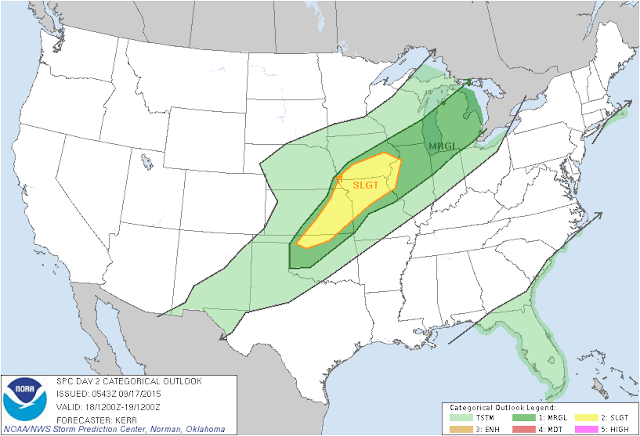
SEVERE WEATHER POSSIBILITY: Taking a look at the risk maps from the fine folks at the Storm Prediction Center, we note that tomorrow and Saturday find us in a "marginal" risk for severe weather. Have a look at the maps, then we'll talk about it, as it figures prominently in the forecast for the next few days...
 |
| This is the SPC Risk Map for Friday. The entire Lower Peninsula could see some gusty thunderstorms with striaght-line winds that could cause some damage, |
 |
| SPC Risk for Saturday. The Southeast half of the Lower Peninsula in play once again, we still think that strong straight-line winds will be the issue here. |
Round 1 is done by lunchtime Friday at the latest. I expect a few AM showers or perhaps a storm in the area until then, Plenty of moisture about, as the upper air dynamics haven't changed. The low-level jet will still be pulling that quality moist air that storms like to nosh on into the area. Wildcard: I'm not certain how much daytime heating we pick up from the sun. How quickly round 1 departs the area and pulls some of those clouds with him will play a key role. Earlier departure = more time for destabilization. A later departure will certainly mitigate the storm threat somewhat. I'll check it out on later forecast model runs, we'll have at least a couple or three to look at.
Round 2 starts Friday; Showers and thunderstorms will develop and some of those could be severe. You'll for sure want to take an umbrella or rain gear with you and have it handy for Friday Night Football at your local high school! I'm still seeing a bit of spread on arrival time for the second, more robust front. For now, I'll say anytime after 3 PM on Friday, expect scattered to numerous showers and storms to develop, some of these will have gusty winds, heavy rain and perhaps even a bit of hail in them. Have a look at this map:
After we get through that rain and storminess, the cold front will have officially swung through the area. It will clear the skies and bring us more in line with the seasonal average for temperatures, which is right around 70 degrees in mid to late September.
LOOKING AHEAD: Clear skies and readings in the 70's for the next several days, with low rain chances, The next credible chance at any widespread shower or storm activity doesn't show up until a week from Sunday!
Here the forecast:
Today - Mainly sunny to start, increasing PM clouds, warm, High 84.
Tonight - Becoming mainly cloudy, developing showers and thunderstorms late, lows near 60.
Friday - Rains taper off as the morning progresses, then partly sunny, with clouds and showers re-developing toward evening. High 78.
Friday Night - Partly to mainly cloudy, showers and storms redevelop after 6 PM. Some could be severe, lows roll back to 60.
Saturday - AM showers and thunderstorms should be gone by lunchtime, clearing and not as warm. High 69.
Sunday - Mainly sunny, a few passing clouds. High 68.
Monday - Clear and seasonably cool. High 69.
Tuesday - More sunshine, continued pleasant. High 71.
Wednesday - Sunny and splendid. High 73.
Thursday - Sunny to start, some PM clouds could bring an isolated shower. High 74.
There's the forecast for the next seven days. I'll be looking at fresh model data to update this forecast for you. Have a great one! Blessings.

No comments:
Post a Comment