Saturday, July 28, 2012

Seasonable With A Few Showers...

Good Morning!


Clear skies in South Central Michigan this morning with nice cool temperatures.  We'll be keeping things seasonable and nice for the next few days here, and not a lot of rain in the forecast.  Let's pop the hood.


TEMPERATURES:  Should stay in the range of low to mid 80's for daytime highs with nighttime lows in the 60's, though for tonight, some areas have a chance at dipping all the way into the lower 50's.  The 80's/60's pattern looks to hold pretty much through the entire forecast window.


RAIN:  A series of "ridge runner" disturbances will bring us chances of rain on Monday into Tuesday, then again on Thursday.  As has been the case, showers and storms that do form look to have some gaps, so isolated to scattered will be the rule coverage-wise.  We should stay around a half inch for the coming five days according to the National Weather Service, here's that map:


5 Day Precipitation Forecast


SEVERE WEATHER:  Two words: Not here.  The Storm Prediction Center is forecasting nothing for the Lower Peninsula for the next five days.  The U.P. gets a low end 5% crack at storms on Monday.  Right now that's all there is in the area.  All the severe chances are off in the Plains or over on the Eastern Seaboard.


Grand Rapids NEXRAD is quiet, there's a few clouds on the visible satellite image over southeast Michigan:


Visible Satellite Image
Here's the forecast for Jackson County:


For today, periods of clouds and sunshine, mild, high 81, winds N 5-10 MPH.


Tonight, clear skies and unseasonably cool, lows roll all the way back to 52, winds N 3-8 MPH.


Sunday, partly sunny skies, breezy and a bit warmer, high 83, winds ESE 5-10 MPH.


Sunday night, continued periods of clouds and stars, not quite as cool, lows near 61, winds ESE 3-8 MPH.


Monday, increasing clouds, a chance of widely scattered or scattered showers, perhaps a thunderstorm, high 84.


Tuesday, mainly cloudy, a chance of a scattered shower continues, high 83.


Wednesday, a mix of clouds and sunshine, a widely scattered morning shower can't be ruled out, then breezy and warm, high 86.


Thursday, partly sunny skies cloud over later in the day, a chance of a shower or lonely thunderstorm during the afternoon, high 84.

There's a look at your forecast for the next six days, i do hope you have a great day!  Blessings.

Friday, July 27, 2012

Strong Storms Firing...

Good Afternoon!


While we have scattered showers here in Jackson, strong thunderstorms are firing in the extreme north and south edges of The South Central Michigan Weather Zone, here's a look at the Grand Rapids NEXRAD radar...


A Severe Thunderstorm Watch remains in effect for Branch, Hillsdale, and Lenawee counties in the south zone until 11PM EDT.

SEVERE THUNDERSTORM WATCH - BRANCH, HILLSDALE, LENAWEE

The National Weather Service has issued a Severe Thunderstorm Watch for Branch, Hillsdale, and Lenawee counties until 11PM.  Additionally, strong thunderstorms are firing in both zones of the blog.  Stay tuned for details!

Scattered Showers And Cooler...

Good Morning!


A cloudy start to the day here in South Central Michigan, with just a couple of sprinkles throughout the area.  More substantial rain is out over Lake Michigan and in the northern half of the Lower Peninsula right now.  The shower activity over the lake looks to track into the blog area and wet things in a widely scattered fashion.  Let's take a look under the hood and see what's going on!


TEMPERATURES:  We'll see temperatures stay cooler today, barely making it into the 80's before the day is over under mainly cloudy skies, though some partial clearing will occur south to north.  For the weekend, temperatures warm back up into the mid 80's with a lot of clouds and some peeks of sun mixed in.  It looks like we'll hold that pattern through the weekend, then see readings start to creep back up toward the middle or even upper 80's.


RAIN:  Cloudy skies today should bring in a few widely scattered showers this afternoon and evening, we'll have to mention the chance of a buried thunderstorm as well, especially in the south zone of the blog (more on that below).  After today and tonight, the weekend actually looks fairly dry.  Here's the five day precipitation forecast from the National Weather Service:


5 Day Precipitation Forecast
And it looks like my instinct from yesterday was right.  I said I was inclined to dial back the rainfall totals, the NWS has done that here in this forecast, now we're back down to around a quarter-inch or so for the next five days.


SEVERE WEATHER:  A couple of things to keep an eye on as the day progresses today, the Storm Prediction Center has part of the south zone of the blog under a "slight" risk for severe weather.  Southeastern Calhoun, southern Jackson, Branch, Hillsdale, Lenawee, if you're in those areas, you've got a crack at wind and hail today.  Thankfully no tornado threat in the forecast.  After that, no severe weather forecast for the rest of this 72 hour window.  Here's the map for today...


There's a few scattered showers off to the southwest visible on the Grand Rapids NEXRAD radar, and the satellite shows plenty of cloudiness...


Grand Rapids NEXRAD Radar
Visible Satellite Image
Here's the forecast for Jackson and vicinity:


For today, mostly cloudy skies, and occasional break for sun, expect a few widely scattered showers and perhaps a roaming thunderstorm today, mild, high temperature 81, northerly winds 3-7 MPH.


Tonight, cloudy skies continue with a few breaks for stars, a chance of a lingering shower, lows near 58, winds N 3-8 MPH.


Saturday, cloudy to start, giving way to sunny skies, breezy and mild, highs near 83, winds N 5-10 MPH.


Saturday night, mainly starry skies, possibly a passing cloud or two, breezy and unseasonably cool, lows all the way down near 53, winds N 5-10 MPH.


Sunday, mostly sunny skies, continued breezy, warmer, high 85.


Monday, a mix of clouds and sunshine, chance of a widely scattered shower late, high 84.


Tuesday, cloudy and mild, still the chance of a scattered shower in the afternoon, high 85.


Wednesday, periods of clouds and sunshine, a chance of a widely scattered or scattered shower is still in the picture, high 82.


There's a look at your forecast for the next six days, I do hope you have a great Friday!  Blessings.

Thursday, July 26, 2012

Much Needed Rain, Then A Bit Drier...

Good Morning!


Severe storms moved through to the north of us last night, just clipping the north zone of the blog.  Showers moved through here, and they are just wrapping up at this hour in this neck of the woods.  Rain!  Glorious, needed RAIN!  We'll keep it around here for awhile today as well.  A significant severe weather event is dialed in from Ohio to Connecticut for later today.  A lot to talk about, so we'll go in reverse order again today, time to pop the hood and see what's running in there!


SEVERE WEATHER:  The severe weather threat is over for Michigan today.  Severe storms fired in the northern part of the state last night and in the early morning hours well before daybreak, just brushing Shiawassee county.  If you take a look at the forecast maps from the Storm Prediction Center, you can see that the stage is now set for some major weather issues from extreme southeast Indiana northwest to Massachusetts.  Here's a look at the maps for today, valid at 8AM EDT:


Storm Prediction Center Day 1 Categorical Risk
Storm Prediction Center Day 1 Severe Wind Risk
Storm Prediction Center Day 1 Hail Risk
Note that Michigan is now in just the "general" thunderstorm risk category, so we'll just pick up rain showers and perhaps a buried storm later this afternoon or tonight, but that's it.  If you have friends or family out east, call them, message them, e-mail them, let them know they need to be close to a good source of weather warning information today - and no, outdoor sirens DO NOT COUNT.

As far as days two and three for severe weather, things get fairly quiet, with just low 5% risk bullseyes on the maps for days two and three.  We'll add those maps in later discusssions if need be.  Closer to home...

TEMPERATURES:  We'll keep temperatures down in the mid to upper 80's today and tomorrow, thanks to a surface low tracking north of us today.  Longer range, I think upper 80's may pop up again briefly, perhaps on Tuesday, but shower and storm activity should help hold things in check.  Dewpoints should come down into the low to mid 60's as the day wears on today and right through the weekend, so it won't be as damp and muggy outside either.  Last night at midnight before the rains came, we had heat index values at 90 degrees in Jackson and 89 in Ann Arbor, due mainly to the humid air!


RAIN:  Once we get the showers out of here this morning, we should be set until late this evening or tomorrow.  There's still a chance of showers and perhaps a thunderstorm, but nothing like what we just finished up with to the north of us, or what's forecast for out east.  Conditions will still favor some widely scattered or scattered showers, possibly a roaming storm or two, and computer forecast modeling supports that, but no unruly mobs of storms expected.


The National Weather Service is forecasting around an inch over the next five days for the blog area, and that seems to fit for now, though in the back of my mind I want to dial it back to around half inch.  We'll leave it as is for now and check it later.  Here's that map:


5 Day Precipitation Forecast
If I bust low on this part of the forecast, I will embrace it lovingly, as we need all the rain we can get.  Crops are basically at the point of no return now, so, sadly we'll have to expect food prices to climb some in the coming months.


Looking at current conditions, plenty of cloud cover that should stay with us through the day with some breaks here and there are visible on the satellite image:


Visible Satellite Image
Grand Rapids NEXRAD radar shows we've gotten the rain out of here for the time being:


Grand Rapids NEXRAD Radar Image
And here's the forecast for Jackson County:


For today, mainly cloudy skies with a few breaks for sun, a chance of scattered showers and perhaps a thunderstorm re-forming this afternoon, warm and still muggy with a high of 84, winds SW 3-8 MPH.


Tonight, skies continue mostly cloudy with a chance at scattered showers and thunderstorms, lows down to 65, winds SW 3-8 MPH.

Friday, a mix of clouds and sunshine, chance at a widely scattered or scattered shower or lonely thunderstorm, high 83, winds SW turning NW 5-10 MPH.


Friday night, periods of clouds and stars, we still can't rule out a scattered shower or hit and run thunderstorm, a bit less humid with lows rolling back to 62, winds turn NNW calm to 6 MPH.


Saturday, mostly sunny skies with a few passing clouds, seasonably warm and pleasant, high 83.


Sunday, more sun than clouds, continued pleasantly warm, high 84.


Monday, clouds roll in as the day progresses, becoming mainly cloudy by late afternoon with a chance at scattered showers and thunderstorms, a bit more humid, high 85.


Tuesday, mostly cloudy skies, a chance of widely scattered to scattered showers and thunderstorms after lunchtime, high 86.


There's a look at your forecast for the next six days.  I do hope that you have a great Thursday!  Blessings.

SEVERE THUNDERSTORM WARNING - SHIAWASSEE

SEVERE THUNDERSTORM WARNING - Northeast Shiawassee County until 2:30AM


Storm that prompted the warning can produce winds up to 60MPH and penny sized hail.  Storm tracking SE @ 45MPH, seek shelter until they pass!

Wednesday, July 25, 2012

SEVERE THUNDERSTORM WATCHES ISSUED

The National Weather Service has issued a SEVERE THUNDERSTORM WATCH for the following counties in The South Central Michigan Weather Zone
  • Clinton until 3AM
  • Livingston until 5AM
  • Shiawassee until 5AM
  • Washtenaw until 5AM
Have a good source of warning information available and check the blog as well!

Severe Weather Risk Update...

Good Afternoon!

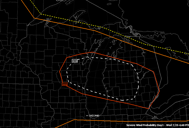
Just a quick update on the severe weather situation.  The Storm Prediction Center has refined their targets again for the rest of the forecast window.  Look at this image with the updated risk areas:

The white SIG indicates the best chance for damaging weather, such as wind, hail or tornadoes.  At this point it looks like straight-line winds will be the problem.
Clinton, Shiawassee, Eaton, Ingham - you all have the best shot at storms that will produce high winds tonight.  As I indicated this morning it looked like the severe weather would be more of a north zone problem, and this seems to bear that out.

We'll keep an eye on it for you and let you know if things start popping!

Heat On The Move...Warming Up Again Today

Good Morning!


When we last talked, I was telling you about a 30% risk bullseye within a "slight" risk category for severe weather today.  The Storm Prediction Center has updated their forecast, and as a result, the risk blobs have moved and changed shape.  We'll pop the hood as usual, but go in a little different order today, starting with the severe weather outlook and working backward.  Off we go!


SEVERE WEATHER:  The Storm Prediction Center has left the slight risk in, but the 30% risk has moved and become basically a north zone concern.  Here's a look at the map with the 30% severe wind risk area, inside the red potato-shaped ring.  I have the county map underneath it for you.


Severe Wind Forecast Day 1, North Zone is in, South Zone out at the moment.
As you can see, parts of Eaton, Ingham, Livingston, Clinton and Shiawassee are in the potential for severe and damaging wind gusts today.  Thankfully, hail and tornado probabilities are low.


Tomorrow, we still have a slight risk, but the better odds move into Ohio and Pennsylvania.  I suspect SPC will push the risk up to moderate from slight at some point during the day today.  Here's a look at the maps for days two and three for you:


Day 2 SPC Forecast, don't be shocked if the 30% red area becomes a Moderate risk before the end of the day.
Day 3 SPC Forecast, just low 5% chance for extreme SE Michigan, this would be a South Zone matter, a Lenawee and  possibly Washtenaw issue.
RAIN:  This is a bit drier look than we have seen in past forecasts, and it won't do much to help the drought that we're in, but still, any rain is better than none.  The National Weather Service is predicting between three-quarters of an inch and an inch of rain over the next five days.  here's a look at that map for you:


Computer modeling indicates a chance of rain in the forecast for later today through Friday; in the south zone anything we get will have plenty of space between showers, the north zone looks to have a tad bit more uniform coverage.  


Currently Grand Rapids NEXRAD is showing some showers and storms off in West Michigan.  They are weakening as they move east, so we may get a little something, but it shouldn't amount to a lot.  We could see those rebuild this afternoon and evening with daytime heating and moist, unstable air for storms to nosh on, so they could pack a punch if they get rolling.  Here's the current radar picture for you:


Grand Rapids NEXRAD image.  These storms have fizzled as they move into the dry air ahead of the advancing warm front.  Hot and steamy when the rain ends!
TEMPERATURES:  We'll see temperatures that are not quite as warm as they have been in past days, along with lower dewpoints and southeasterly breezes for now with clouds rolling in, but then as a warm front moves through, we see temperatures and dewpoint values start to climb once more, and winds swing back around to the southwest on the back side of the front, pushing hotter, more humid air closer in here again.  We'll see temperatures climb back into the 90's with heat index values getting into the upper 90's or better as the day wears on.  That trend should stay with us for the next day or two.  Welcome back to hot and muggy.


Here's a look at the visible satellite for you:


Visible Satellite - you can sort of pick out where the hot, muggy air is on the back of the warm front, in this image it's about to move on-shore and into West Michigan (Benton Harbor, Holland).  Northern Illinois is already heating up, hence the clear skies with just a bit of high cirrus.
And here's the forecast for Jackson and surrounding areas including Grass Lake and Parma:


For today, periods of clouds and sunshine, a chance of a widely scattered or scattered shower  or storm earlier in the day as a warm front moves through, then becoming hot and muggy, showers and storms could re-build this afternoon, high 90, SE winds become SW 8-15 MPH.

Tonight, partly cloudy skies, breezy, still the chance of widely scattered or scattered showers or a couple of roaming thunderstorms, especially north, nighttime lows only roll back to 73, winds SW 8-15 MPH.  Any storms that form could be severe, with high winds as the primary concern.


Thursday, periods of clouds and sunshine, an isolated or widely scattered shower or thunderstorm is still possible, warm and muggy, high 91, winds SW 7-14 MPH.


Thursday night, mostly cloudy skies, we still can't rule out the chance of a widely scattered shower or lonely thunderstorm in spots, nighttime low of 64, winds SW 5-10 MPH.


Friday, mostly cloudy skies, breezy, cooler and less humid, a widely scattered or scattered shower or storm is possible, high temperature 84, winds NE 5-10 MPH.

Saturday, a mix of clouds and sunshine, breezy, high 81.


Sunday, mostly sunny skies with a couple of passing clouds, pleasant, high 84.


Monday, sunny to start, then clouds increase slowly as the day progresses, continued seasonably warm, high 85.


There's a look at your forecast for the next six days, I do hope you have a great hump day Wednesday!  Blessings.

Tuesday, July 24, 2012

Increased Risk Of Severe Weather...

Good Evening!

The Storm Prediction Center has the blog area under a "slight" risk of severe weather, but within that, there's a 30% risk bullseye.  We'll be keeping an eye on it all for you, so check us out for updates!  Here's a look at the percentage risk map...


Inside the red ring is the 30% area.

Monday, July 23, 2012

Hot And Humid...Multiple Chances At Rain...

Good Morning!


We had a little bit of widely scattered shower activity move through the area in the pre-dawn hours.  Jackson barely picked up anything measurable, the airport recorded .01 of an inch.  That has moved on through, giving way to partly sunny skies and southwesterly breezes.  We'll keep those around for awhile, and have another crack at some showers and thunderstorms later today.  Time to pop the hood and see what's running under there!


TEMPERATURES:  The heat dome is fighting to invade once again, but it'll stop just short of us.  Doesn't really matter where it is though, as we'll still be plenty hot.  Temperatures will climb into the mid 90's in most spots around the blog area today, and moist dewpoints in the middle 60's or better raise the chance of triple digit heat index values this afternoon.  Here's the wildcard.  We have a chance at showers and storms this afternoon, and any rain will cool it down for us, if only briefly.  We'll start to see the heat go down as we approach the weekend.


RAIN:  We didn't see much this morning under the cover of darkness, but not to worry.  We'll have another shot at some rain later today, and it looks like a couple more chances after that through the rest of the week.  Any rain we get is beneficial and needed!  The National Weather Service has changed the look for South Central Michigan and rolled back the five day rain totals a bit, as I figured they would.  I predicted a shade over 2 inches on the high side for most parts of the blog, and the NWS is now suggesting around an inch and-a-half.  Here's the map for you:
National Weather Service 5 Day Precipitation Forecast
Computer modeling is suggesting widely scattered showers late tonight, then again on Wednesday night and Thursday night.  We'll shore that up as more data becomes available.


SEVERE WEATHER:  Here's something that I haven't had to say in a while.  We are under a risk for severe weather for the better part of the three days covered by the Storm Prediction Center.  Today and Wednesday we are under a "slight" risk bullseye, and tomorrow, just the garden variety thunderstorms are forecast.  Here's the outlooks from the SPC for the next three days, each one valid at 8AM EDT:


Day 1 Outlook
Day 2 Outlook 
Day 3 Outlook
The greatest threat from any storms that do develop are wind and hail.  Nothing that should produce a tornado is expected.

Some clouds off to the southwest and moving away from us here on the satellite image:


Visible Satellite Image
And here's the forecast for Jackson County:


For today, periods of clouds and sun, hot and muggy, isolated to widely scattered showers or thunderstorms are possible this afternoon, high 94, winds SSW 7-14 MPH.


Tonight, mostly cloudy skies, still the chance of an isolated or scattered shower or thunderstorm, low 67, winds SW 5-10 MPH.


Tuesday, more sun than clouds, not quite as warm, high 86, winds NW 5-10 MPH.


Tuesday night, mixed clouds and stars, cooler, nighttime low 64, winds NE 5-10 MPH.


Wednesday, continued partly sunny and seasonably warm, chance of an afternoon or evening shower or thunderstorm, high 85.


Thursday, cloudy with scattered showers and thunderstorms high 84.


Friday, continued mostly cloudy, a scattered shower or storm still can't be ruled out, high 82.


Saturday, a mix of clouds and sunshine, cooler and less humid, high 80.


That's a look at your forecast for the next six days, I do hope you have a great Monday! Blessings.
Sunday, July 22, 2012

Hot Once Again...Rain Chances Creeping Up...

Good Evening!

After a busy day with church and working the straight job, I finally have the chance to sit and pore over some data and modeling, and I can sum it up in one word...HOT.  As much as I hate to say this, it sure looks like we are poised to be thrust into the oven again, at least for tomorrow.  This will be a little different than previous trips to the blast furnace for South Central Michigan though...Let's pop the hood and see what's running under there.

TEMPERATURES:  We'll see temperatures climb into the mid 90's for tomorrow, with dewpoint values into the 70's that will allow the heat index to make a run at 100.  The heat dome is trying to elbow it's way back in here, and modeling indicates that we'll be on the cusp of it.  After tomorrow, we'll see temperatures start easing off through the balance of the week, as it looks like we get some help from an unusual source...RAIN.  Rain-cooled air is a definite possibility based on the setup.  I'll have more for you about the "Ring Of Fire" in another post.

RAIN:  I surely hope that I am not jinxing it for us, but things are shaping up for us to have multiple shots at some needed, beneficial rain as early as daybreak tomorrow.  With us sitting right at the cusp of the ridge and heat dome, we're in good position to catch upper waves and disturbances sliding off the back side of the ridge.  Each one that come through gives us a chance at some showers and thunderstorms, and given the heat and humidity, I don't think the moist, unstable air that thunderstorms love to nosh on will be lacking.

The National Weather Service is also thinking along similar lines, here's their forecast map regarding precipitation for the next five days...

5 Day Precipitation Forecast
That's the juiciest map I have seen in quite awhile for rain chances!  That 3 inch bullseye over by Port Huron looks especially good given the drought conditions we are currently experiencing.  Here in the blog area, I'm thinking we'll top out at a little over two inches.  If I am too low with that prediction, so much the better!  Our best shots at rain come during the early and middle parts of the week, with a clearing trend setting up in time for the weekend.  Here's a look at the GFS computer model valid at 5AM tomorrow, showing the setup for the day...

GFS Computer Model Forecast for Monday 7/23, valid at 5AM EDT
SEVERE WEATHER:  The Storm Prediction Center has us under a "slight" risk for severe storms tomorrow.  The biggest threat that we need to be concerned about is for wind and hail.  Here's a look at the forecast map from SPC:

Severe Weather Forecast Valid 8AM EDT 7/23/12
As you see, a slight risk for us, then down into the Ohio Valley, and then back up through the Appalachians and into New England, along with a second area way out west in Montana and the extreme west Dakotas.

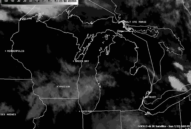
Here's a look at the infrared satellite, just some passing clouds and some shower activity over Lake Michigan:

Infrared Satellite Image
Here's the local forecast for Jackson County:

For tonight, periods of clouds and stars, muggy, a chance at an isolated or widely scattered shower or storm, lows only down to 69, winds SW 5-10 MPH.

Tomorrow, a mixture of clouds and sunshine, a chance of widely scattered to scattered showers and thunderstorms in the afternoon, hot with a high of 94, winds SW 7-13 MPH.

Monday night, continued muggy and warm under cloudy skies with a chance of showers and thunderstorms, low 68.  Winds turn NNW 5-10 MPH.

Tuesday, periods of clouds and sunshine, not as warm or humid, high 88, winds NE 5-10 MPH.

Wednesday, partly sunny skies, chance of a scattered shower or thunderstorm, high 84.

Thursday, mostly cloudy, a few peeks of sunshine, chance of scattered showers or a thunderstorm, high 83.

Friday, mostly sunny skies with a few passing clouds, high 82.

There's a look at your forecast for the next six days, i do hope that you have a great evening and a good day tomorrow!  Blessings.