Good Morning!
A mix of clouds and sunshine and some mild temperatures for mid-autumn greet us this morning in the South Central Michigan Weather Zone today! We'll keep the mild stuff around as we push some very spotty shower activity out of here, then we enjoy some sunshine. Soak it up now, because the rest of the week features some shower and thunderstorm activity. Let's take a deeper dive and see what we have on tap for the next several days!
TEMPERATURES: The mercury climbs to some unseasonably mild levels today in advance of a cold front. Warmer southerly flow pushed mild air in here overnight that caused temperatures to hold fairly steady or even rise. Pretty much all of the reporting stations are checking in at 50 or better, with some temperatures already working on 60 degrees at 9AM. We get a cold front coming through this evening and tonight that kicks off some precipitation (more on that below) and then we cool back into the 50's for the next few days with gray, rainy conditions. Here's a look at readings this hour:
RAIN: Enjoy the sunshine and mild conditions because you don't see them anymore after today for awhile! We stay dry through the day, but clouds thicken and we get a couple of showers and possibly a thunderstorm in here around time for the evening drive home from work. The main body of the rain comes in closer to 11 PM, with falling temperatures and a better coverage of showers and some thunderstorms. Take a peek at the National Weather Service outlook:
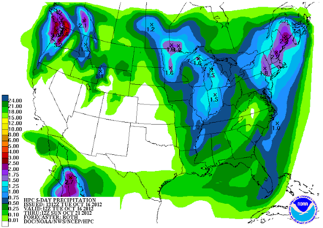 |
| 5 Day Precipitation Forecast |
As you can see, you'll definitely need the umbrella here as once the rain starts, as it sticks with us pretty much into the start of the weekend, with some breaks here and there. Friday Night Football will be a chilly and damp affair this week in the lion's share of the stadiums in the blog area. I don't really know how much sunshine we get during those breaks, though, just yet, as the low pressure system that will cause all this fuss looks to be a pretty substantial one.
SEVERE WEATHER: Taking a look from the perch today, we shouldn't have any severe weather issues to worry about, even with all of the rain and storm activity coming. Take a look at the forecast from the Storm Prediction Center and you see that the severe threat is well to the south of us here in Michigan...
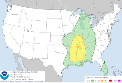 |
| Storm Prediction Center Day 1 Outlook |
A 15-20 degree temperature swing usually brings some good storms with it, so don't be surprised to see a couple of strong, but not severe storms with gusty winds later today and into the nighttime hours.
Some scattered clouds around the area at this hour, but lots of sunshine to pass around :)
Here's the forecast for Jackson and surrounding areas including Spring Arbor and Rives Junction:
Today, mainly sunny skies with some passing clouds that increase during the afternoon, a couple of isolated showers should develop after 5 PM, high 70, winds S 7-14 MPH.
Tonight, becoming overcast, scattered to numerous showers and a few thunderstorms, turning cooler, lows drop back to 51, winds SSE 10-15 MPH.
Thursday, cloudy skies, rainy, high 54, winds SE 6-12 MPH.
Thursday night, continued cloudy and wet, but rain does start to taper off as the evening progresses, low 41, winds SE 5-10 MPH.
Friday, continued cloudy, still a couple of showers around, high only 53.
Saturday, mainly cloudy, but some partial clearing during the day, still a couple of lingering hit or miss showers, high 55.
Sunday, becoming sunny and seasonably pleasant, high 59.
Monday, mostly sunny skies with maybe a couple of passing clouds, warmer, high 63.
Tuesday, periods of clouds and sunshine, warmer still, chance of a few afternoon scattered showers, high 65.
There's a look at your forecast for the next six days, I do hope that you have a great Wednesday! Blessings.


