One of the hottest days of the year is here, but some form of relief is on tap for us for in another day or two. A pair of 588 heat domes have set up shop in the southwest and southeast parts of the nation, joined forces through the deep south and southern Plains, and are making their presence known with temperatures in the middle 90's all the way up into New England! Here's a map from the GFS computer forecast model. Where the 588 lines are is where the heat is. There's also a 594 circle in southwestern PA and the Virginias, that's good for intense heat, with air temperatures likely exceeding 100+!
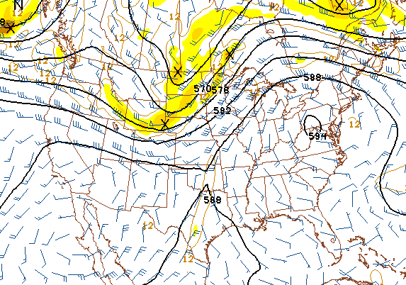 |
| GFS Computer Forecast Model Map, 500mb Thickness and Vorticity |
TEMPERATURES: Can be summed up in one word: HOT! We see temperatures edge as close to 100 as they have all year today, with high temperatures right around 95. Heat index values will easily make it into the triple digits, against dew point values of 60 or better, so this heat will be a muggy, uncomfortable kind of heat that saps your energy if you are outside. It's already warm around the area, with most spots in the blog area already reporting temperatures pushing 80 degrees before 9AM! Here's a look at temperatures around the US right now...
 |
| US Surface Temperature Reports, 9:00AM EDT |
 |
| National Weather Service 5 Day Precipitation Forecast |
 |
| SPC Day 1 Severe Outlook |
 |
| SPC Day 2 Severe Outlook |
 |
| Visible Satellite Image |
For today mainly clear skies with perhaps a passing cloud or two, hot, high temperature 94, heat index values at or above 100. SW winds 7-14 MPH.
Tonight, mostly starry skies, again a few clouds may float by, still warm, nighttime lows only roll back to 68, winds start SW but turn NW 6-12 MPH.
Thursday, a mix of clouds and sunshine, perhaps the chance of an isolated or widely scattered shower or a rogue thunderstorm, cooler, high temperature 85, winds W 7-14 MPH.
Thursday night, some clouds and stars mix, much cooler, nighttime lows drop to 59, NNW winds 5-10 MPH.
Friday, variably cloudy skies, cooling a bit more, with a high of 81.
Saturday, continued periods of clouds and sunshine, high 81.
Sunday, partly sunny, a slight chance of an isolated or widely scattered afternoon shower or pop-up thunderstorm, high 83.
Monday, clear skies, comfortable, high 79.
There's a look at your forecast for the next six days, I do hope your hump day Wednesday is a great one! Blessings.
No comments:
Post a Comment