Sunny skies have returned to the area after the clouds broke late yesterday. The warm-up is on the way as we breeze right through the 70's today and push 90 a couple of times the next few days. We'll also have a shot at some rain over the next few days as well. Let's take a deeper dive and see what we have going on out there...
TEMPERATURES: We see temperatures right at or just above seasonal levels today, then things warm up to the upper 80's on Thursday, with a brief moderation in temperature. The weekend looks very warm, with temperatures in the upper 80's again. I would not be surprised to see a 90 or two as we kick off summer with the arrival of Memorial Day. As a whole we run well above average, which is around 75 in this neck of the woods for this time of year. Tuesday we'll see a cool down, as temperatures are expected to roll back into the lower 70's.
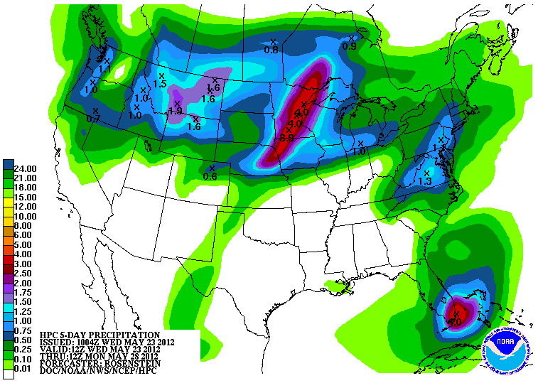
RAIN: Things are looking a bit wetter now than they have in past days, with the National Weather Service suggesting that the southern half of lower Michigan will pick up about an inch of rain the next five days. The best chances of rain look to be in the weekend, with a chance of showers and storms each day starting on Saturday and going all the way through Tuesday. My take on things is that we'll stay dry on Saturday, and we pick up some rain on Sunday into Monday. Here's a look at the National Weather Service map for total rainfall between now and 8AM Monday...
SEVERE WEATHER: You'll have to go way up and over to the far western Upper Peninsula for that. Tomorrow the Storm Prediction Center is showing a "slight" risk for severe storms in the western part of the U.P. Here's that map for you, valid at 8AM tomorrow.

NO thunderstorms of any kind expected here for the next three days.
Bright blue skies in Jackson this morning, Grand Rapids NEXRAD radar is quiet as Sunday Mass, here's the visible satellite image, showing not a whole lot going on in Michigan right now.

Here's the local forecast for Jackson and surrounding communities including Spring Arbor and Brooklyn:
For today, sunny, pleasant, high 77, winds SSE 5-10 MPH.
Tonight, clear skies with maybe a passing cloud or two, low 57, winds SSE 3-8 MPH.
Thursday, continued clear, warmer, high 85, winds southerly 8-15 MPH.
Thursday night, mostly clear skies, a few clouds pass by, low of 63, winds SSW 8-15 MPH.
Friday, a mix of clouds and sunshine with a small chance of an isolated shower, high of 80.
Saturday, partly sunny to start then clouds increase during the day with a chance of scattered showers or a lonely thunderstorm, high 80.
Sunday, cloudy, a chance of scattered to numerous showers and thunderstorms, high 85.
Memorial Day, cloudy with a chance of scattered showers and thunderstorms, high 85.
There's your local forecast for the next 6 days, I do hope you have a great Wednesday! Blessings!
No comments:
Post a Comment