RAIN: We are sitting near the hump of an upper ridge that has established itself in the Deep South. As a result all of the storm activity will be shunted toward us the next few days, as the warmer air continues to build in here. We'll see more on that in the severe weather portion of this post. In the meantime, this forecast is looking even wetter than the one yesterday. Here's the map showing the National Weather Service's guess at rain for the next 5 days. Just look at that almost 4 inch bullseye!

Here in the blog's area, we're forecast to pick up between two and three inches of rain as you move north. For my money, I can buy two inches, but that three inch plus seems maybe a tad high to me. The question will be how do tomorrow and Thursday play out. At any rate, I fully expect a pattern of rain every other day, chance of rain between, and clouds for the whole thing to persist through the whole week, and with the warmer air moving in it will not take a whole lot to kick off storms that will drop some good rain totals. In case you're unsure, this is the day with a chance of rain, but cloudy all day.
SEVERE WEATHER: A quick sidebar, after the devastation of April last year in Alabama, this year that state went the entire month with no tornadoes. Good for them, they needed it! Now, back to Michigan. For today, basically the entire eastern half of the on is under at least a general risk of thunderstorms, and that includes all of Michigan. The "slight" bullseye is over the far north central Plains. Here's the Day 1 map, all maps are as usual valid at 8AM that day:

Tomorrow, Day 2, more of the same, with the "slight" zone covering the west half of the Upper Peninsula, WI, northern IL, IA, southern MN, a sliver of SD, and eastern NE:

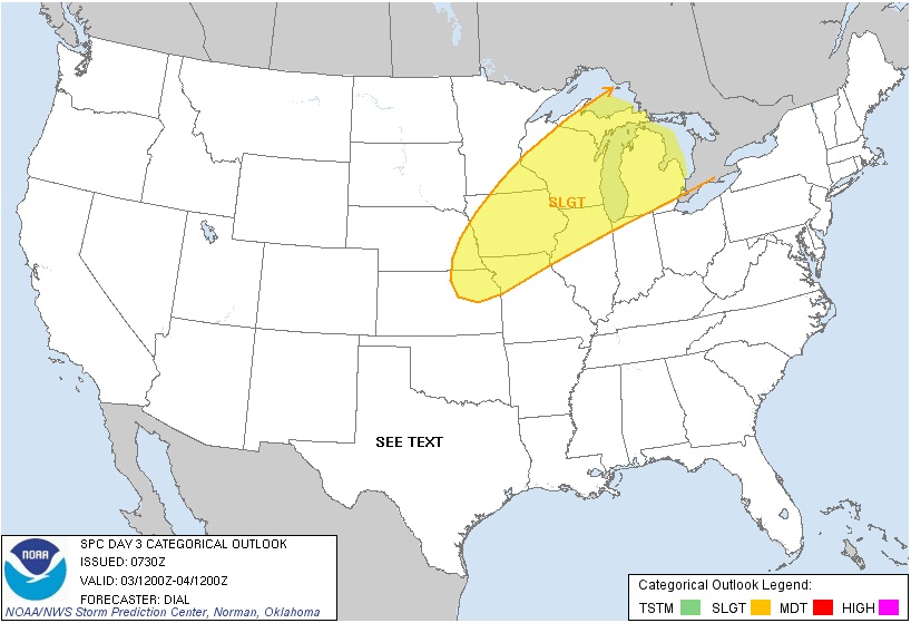
Now take a look at Day 3: It's baaack...We had a severe risk area drawn on us a couple of days ago - it vanished, now it's here again. All of Michigan is under the "slight" risk of severe storms. Right now any we get are forecast to be more hail and wind producers than to be tornadic, but you can never truly know until you see how the atmosphere stacks up the day of.
Here's a look at the visible satellite image:

It's time for the local forecast for Jackson County:
For today, cloudy skies, maybe a peek of sun, mild, chance of a scattered shower in the afternoon, high near 71, winds swinging from NW to SE 5-10 MPH.
Tonight, cloudy skies, still a chance of a shower late, nighttime lows near 50. Winds SW increasing to 10-20 MPH.
Wednesday, mainly cloudy skies with a few peeks of sunshine, chance of showers and thunderstorms, high of 80 with winds SW 15-25 MPH.
Wednesday night, some clearing, making it partly starry skies, low of 62, winds SW 5-10 MPH.
Thursday, periods of clouds and sunshine, a chance of scattered to numerous showers and thunderstorms, high 85, winds SW 15-25 MPH.
Friday, cloudy skies a peek or two of sunshine, chance of showers and perhaps a thunderstorm, high of 83.
Saturday, cloudy skies and cooler, chance of showers, high of 72.
Sunday, mainly sunny skies, seasonable, high of 65.
There's a look at your weather for the next 6 days, I hope you do have a good day. Blessings!
No comments:
Post a Comment