Wednesday, June 13, 2012

Wonderful Wednesday Leads To A Warm Weekend!

Good Morning!


A cool start to another seasonably mild day for South Central Michigan, with abundant blue skies, pleasant conditions, and no rain.  Lows rolled back into the 40's in many spots across the blog last night.  You don't see that headed into mid-June too often this far south in Michigan!  That no rain situation I just mentioned is becoming a concern, as more watering is the only way to keep things green and growing, and the risk of brush fires is slowly creeping up as well.  No organized rain in sight for the next several days.  That's good news for those with outdoor activities, including race weekend, and bad news for those growing things, such as farmers.  Let's take a deeper dive and see what's going on...


TEMPERATURES:  Canadian high pressure has rolled in and parked itself on top of us.  As a result, northeasterly winds today keep our temperatures in the low 70's and humidity down.  It's a perfect day for any outdoor activity. After this, temperatures start climbing, and by Friday, as that high pressure center moves east, putting us into southwesterly flow, temperatures top out in the upper 80's in time for race weekend, with a 90 or two a possibility.  More on that for the area around Michigan International Speedway in the RaceCAST below.  Going into the new week, things look much warmer, with a heat dome indicated by computer modeling putting us into 90 degree territory around midweek.


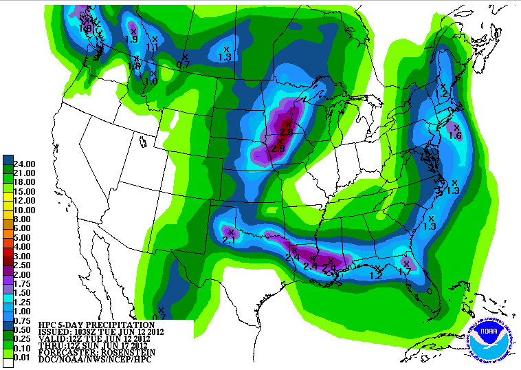
RAIN:  Hmph.  Not anywhere close to us.  The next five days still look dry for South Central Michigan, though the GFS computer model wants to bring just a smidge of moisture in here on Sunday.  For me, we stay dry, and if by chance we do stumble across some rain, looking at it now, you'll see an isolated shower pop up after lunchtime on Sunday, wring itself dry, then dissipate.  If you look at the latest five day precipitation map from the National Weather Service, you see that we aren't bone dry anymore, but we only get a little bit through this area, with more rain forecast as you head west.  This is valid through 8AM Monday.


With the dry conditions, the National Weather Service office in Northern Indiana has issued a Special Weather Statement for Branch and Hillsdale counties.  It doesn't fit any official criteria per se, such as a Red Flag Warning, but the message text seeks to raise awareness of dry and breezy conditions increasing the chance of a brush fire or wildfire if given a spark.  I'll post that separately.  For lack of a better term, i'll call it a Fire Risk Advisory.  That is MY title for it, not the National Weather Service's.


SEVERE WEATHER:  The Storm Prediction Center says nothing in Michigan the next three days. Can't really say too much beyond that.  Just a general risk of plain vanilla thunderstorms in the western Upper Peninsula tomorrow.  "Slight" risk areas up in the northern Plains today, along with TX, OK, CO, NM and KS.  That moves into the northern edge of Tornado Alley tomorrow, and a small 5% risk area in the central US, spreading into WY and MT on Friday.  That's it.


Day 1
Day 2
Day 3
RaceCAST:  I've seen the buses and campers slowly trickling into the Brooklyn/Jackson area of the blog's South Zone as they converge on Michigan International Speedway, and any that aren't already here will show up today or tomorrow I'm sure.  Race fans will have a nice couple of days to relax around MIS before things rev up this weekend.  Clear skies through early Saturday, then a mix of clouds and sunshine for the races each day.  Temperatures top out in the upper 80's, however local to the track, I would not at all be surprised to see 91 with heat index values around 94.  Lows should be around 60 both Friday and Saturday night.  Rain chances are pretty much non-existent, but owing to the GFS showing a touch of dampness on Sunday, for now,  I will leave a small chance at an isolated shower in the forecast.


Grand Rapids NEXRAD radar is quiet, and the visible satellite shows nothing but a few wispy clouds out over Lake Michigan.


Here's the local forecast for Jackson and surrounding communities including Pleasant Lake and Parma:


For today, sunny skies with a passing cloud here and there, cooler than normal but still pleasant, a great day for outdoor activity with a high of 74, winds NE 5-10 MPH.


Tonight, mainly starry skies, a few clouds float by, lows roll all the way back to 46, winds E 5-10 MPH.


Thursday, continued sunny with a couple of lonely clouds floating by, warmer, another winner, high 78, winds ESE 7-14 MPH.


Thursday night, more clear skies, not quite as cool, lows around 52, winds ESE 5-10 MPH.


Friday, bright blue skies and warmer still, highs reach 85.


Saturday, mainly sunny to start, a few clouds start mixing in later in the day, very warm with a high of 89.


Sunday, periods of clouds and sunshine, just a slight chance at an isolated shower, high 87.


Monday, clouds and sunshine continue to mix and match during the day, still the outside chance at a lone shower, high 85.


That's a look at your forecast for the next six days, I do hope you have a wonderful Wednesday! Blessings.

Tuesday, June 12, 2012

Plenty Of Sun, Plenty Of Fun...

Good Morning!


I tell you what, rain has been SUCH a tease and in SHORT supply.  We get a little bit here and there, and then we get a reasonably organized system approaching us, then it fizzles, or just flat out misses you.  The line of showers and thunderstorms did come through and drop a little bit of needed rain.  On the back side of that, much cooler weather for the next few days, then temperatures start to warm again in time for the end of the week.  Let's take a look at what we have going in the area - one deeper dive coming up!


TEMPERATURES:  New computer modeling has shuffled the deck for the weekend.  Enjoy the cooling now, because we'll see warm conditions in time for the weekend, including out at Michigan International Speedway for the Alliance Truck Parts 250 and the Quicken Loans 400 on Saturday and Sunday (No, I am not being paid for mentioning the names of the races!).  We'll have more on that in the RaceCAST below.  Temperatures will roll back into the 70's, then slowly start creeping back up Thursday.  Here's temperatures around the nation right now.


RAIN:  Yeah, right.  The only rain your yard will see in this area is what comes from the sprinklers.  The National Weather Service is predicting zip in the way of rain for the next five days, and the models sure line up with that.  Hot and dry is the name of the game.  Here's a look at the 5 day precipitation map...


So far the rain deficit is creeping up on the two inch mark...we'll add to that gap over the next several days.


SEVERE WEATHER:  No severe weather on tap for Michigan for the next three days.  Today is the only day currently with any severe risk anywhere in the US according to the Storm Prediction Center.  After that, just 5% probability areas and chances for garden variety thunderstorms.


RaceCAST:  Two races, one weekend, lots of fun.  Lots of sun as well, along with very warm weather.  Temperatures should be in the mid to upper 80's with periods of clouds and sunshine.  Of the two days, Sunday will be the warmer of the two, with a forecast high right now of 86.  No rain expected, it should be an enjoyable weekend for everyone headed this way to watch the cars "run fast, turn left".  Dew points around 60 degrees should yield heat index values at or above 90 degrees, but at the track I would not be surprised to see heat index values in the mid 90's.


Grand Rapids NEXRAD radar is quiet.  The clouds are around us, but not over, yielding bright blue skies in south central Michigan at this hour.  Here's a look at the local forecast for Jackson and surrounding communities including Napoleon and Spring Arbor.


For today, sunny skies, pleasant, high 76, winds WNW 6-12 MPH.


Tonight, clear skies, very cool, low 45.  Winds N 5-10 MPH.


Wednesday, continued sunny, a cloud or two will pass during the day, unseasonably cool, high 71, winds N 5-10 MPH.


Wednesday night, mostly starry skies, a bit warmer, lows 46, winds NE 5-10 MPH.


Thursday, lots of sunshine, seasonably pleasant with a stray cloud or two floating by, high of 78.


Friday, still sunny and warm, high 83.


Saturday, a mix of clouds and sunshine, warm, high 85.


Sunday, periods of clouds and sunshine, very warm, high of 87.


There's a look at your forecast for the next six days.  I do hope you have a great Tuesday!  Blessings.

Monday, June 11, 2012

Storms Then Cooler...

Good Morning!


After a very warm weekend in South Central Michigan with a record-tying high of 91 yesterday in Jackson, we finally see some moderation in temperatures a bit, with some showers and thunderstorms likely later today.  Once we get though with that, we'll have temperatures back into the 70's.  Let's take a look and see what we have with a deeper dive.


TEMPERATURES:  After a very warm weekend we'll cool things down into the 70's and then warm back up into the mid 80's for Father's Day Weekend - or if you're a NASCAR junkie, Race Weekend!  Mid-range computer modeling doesn't show any sweltering heat or high humidity for the next several days.  We'll be on the back side of an upper disturbance that is touching off some showers south of us, and storms are approaching from the west.  More on that below.


RAIN:  We may see some rain today, though it doesn't look like it will be a whole lot.  At this point we'll take anything that we can get.  Things are pretty dry in this part of Michigan, with most areas at least a couple of inches below where they should be for rainfall.  An upper disturbance should touch off some showers, then there is a more organized linear system approaching from the west.  That westerly system will be the soaker if it can hold together as it crosses into Michigan from Chicago and Milwaukee.  At this hour, the northern part of the line looks like it is weakening with eastbound travel, so that one may be gone, and we'll have to wait for daytime heating to perhaps build up some storms later today.  Here's the map for what the National Weather Service thinks we'll get over the next five days with respect to rainfall...


As you can see, not much at all, just a meager bit of rain, if any at all.


SEVERE WEATHER:  Just the "general" risk for garden variety thunderstorms in this part of the world today according to the Storm Prediction Center.  That being said, there is a small window of opportunity for some severe weather later this afternoon into this evening, located just ahead of the cold front approaching from the west.  We'll have to see how everything comes together, and afternoon heating will be a key part of the equation.  Too much cloud cover, and we don't get warm enough to destabilize the atmosphere sufficiently for rough storms to fire.  After that front moves through, nothing much.  Here's the maps, valid at 8AM.


 Day 1
Day 2

Here's a look at the Detroit NEXRAD radar, as it is closer to the rain that is occurring in east Michigan, so we can get a better look at it from that site.  The visible satellite has lots of clouds on it.  You see the clouds connected with the shower activity in southeast Michigan, and off to the west, the clouds that belong to the storms ahead of the cold front.


 Detroit (DTX) NEXRAD Reflectivity
Visible Satellite

Here's your forecast for Jackson County...


Thunderstorms Close By

Good Evening!


After a warm humid day with more sun than I expected, the rains are finally getting close.  We have a semi-organized line of storms from Ingham County tracking roughly straight southwest all the way to Branch County and the state line.  Some of these may get strong, but I don't see anything becoming severe until after it moves on east.  Here's a look at the Grand Rapids NEXRAD:


Expect maybe some brief but heavy rain and some gusty winds, as this looks like a hit and run affair.  Forecast tomorrow. 

Missed Ya'll!

Good Morning Everyone!


After being at a baseball tournament ALL WEEKEND, I am back in the saddle and busy getting your forecasts ready!  Stay tuned.  It was hot over in Ben Kouchnerkavich's part of the world this weekend.  I was in Grand Rapids, MI, and had a great time, though I am/was exhausted.  Forecast on the way.