The severe threat didn't develop here as advertised last night, the storms that looked so impressive from northern Illinois through the Chicago area and into northern Indiana went flat as they tracked this way, just leaving us with some scattered shower activity and a couple of isolated thunderstorms. These same storms knocked down trees and produced a couple of tornado warnings as a couple of brief spin-ups were detected over by the lake shore and then in northern Indiana as well. This morning, skies are cloudy but clearing, let's pop the hood and see what we have:
TEMPERATURES: With the passing of the cold front that brought the rain to south central Michigan, we'll see temperatures climb into the low 80's later today, with clearing skies limiting the amount of heating that we actually see. That trend looks to continue for the next several days throughout the area, with primarily sunny skies as well. A ridge/trough pattern will bring a bit cooler northwesterly flow in for at least a couple of days, then winds coming more westerly bring us slightly warmer temperatures, as the ridge with the truly brutal heat stays off to the southwest. For today, we'll still have a good part of the day to get through today before the drier, less humid air winds it's way in.
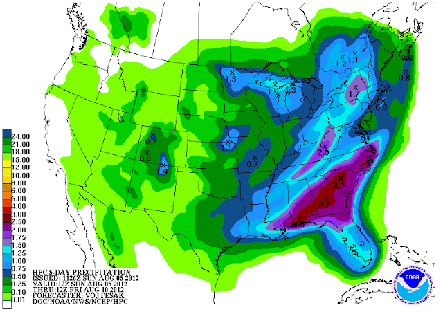
RAIN: We picked up a smidgen of badly needed rain last night and into this morning, but the bad news is, that's about all until late this week. Thursday looks to be the next real chance at any rain beyond the occasional afternoon pop-up shower or thunderstorm that is typical this time of the year in the Midwest. Here's a look at the 5 day precipitation outlook from the National Weather Service:
 |
| 5 Day Precipitation Forecast |
SEVERE WEATHER: The severe weather threat has shifted out of here and to the east, with us just being in the "general" risk area for garden variety storms today, and then nothing for Monday and Tuesday. There's still plenty of moisture in the air at this hour, but with all the clouds, it doesn't look like it will get hot enough to help create the really unstable air that big storms like to work on.
Grand Rapids NEXRAD is quiet, here's a look at the visible satellite image, showing clouds slowly exiting the blog area to the west, then just some scattered clouds behind that:
 |
| Visible Satellite Image |
For today, cloudy skies become clear late this afternoon, cooler and less humid, seasonably pleasant. High 82, winds NW 6-12 MPH.
Tonight, mainly starry skies with perhaps a passing cloud, unseasonably cool nighttime lows roll back to 52, winds NW 5-10 MPH.
Monday, continued sunny and seasonably mild, high of 81, winds NW turning WSW 5-10 MPH.
Monday night, more clear skies and cool temperatures, nighttime lows roll back to 54, winds SW 3-8 MPH.
Tuesday, mostly sunny skies with a few passing clouds, warmer, high 84, winds SW 5-10 MPH.
Wednesday, periods of clouds and sunshine, mild, high 81.
Thursday, mainly cloudy skies with a few peeks at sunshine, a widely scattered shower is possible, high 83.
Friday, continued cloudy, still the chance of a scattered shower, high 80.
There's a look at your forecast for the next six days, I do hope you have a wonderful day! Blessings.
No comments:
Post a Comment