Good Afternoon!
Still seasonably cold in the area with a Canadian Special bringing us cold northerly flow out from north of the border. We expect this pattern to persist for the next few days, then we'll start to see some changes around mid-week. Let's have a look and see what's going on...
A PAIR OF PLAYERS: Two players on the field to be concerned about. The first is an upper low currently over eastern Nebraska/western Iowa, that will become a closed low over the next several hours and progress southeasterly. That is responsible for the Winter Weather Advisories and Winter Storm Warnings well to our south.
The second player is another upper low that is a fair ways into Canada. It's currently several hundred miles northwest of us, but I expect it to be here at some point on Tuesday based on the available forecast data.
WHAT DO THEY DO?: Well, the upper low heading southeast doesn't directly impact us itself, but it does appear that it will change up the track of the Canadian upper low a little bit in our favor. Additionally, this low is the one that New York and New England were concerned would be the third nor'easter in 2 weeks, but the forecast data is indicating that he'll just march right out to sea and keep on going - so no wraparound snow or anything like that to worry about.
The second one in Canada right now? 1) He'll keep cold air working into Michigan until the latter part of the week; 2) Tomorrow night into Tuesday, we'll see the chance of a few flurries or some light snow. I don't really think we'll see a ton in the way of accumulation because there's not a whole lot of moist air for this system to work with.
WARMING UP: Good news! Milder conditions are on the way. I expect to see some 50's and possibly a 60 or two around the area for the weekend. Enjoy it because things change again to start the new work week!
A NEW SHOT OF PRECIPITATION: I expect us to see some sun on Monday, but clouds will thicken as the next weather-maker approaches us from the east. We'll also be close enough to the leading edge of some cold air that there is some uncertainty at this time as to whether we'll be seeing all rain, all snow, or a wintry mix. Behind that, temperatures will be falling back into a more winter-like range with clearing as well.
Here's the forecast:
This evening: Increasing clouds as the night wears on, lows roll back to near 22.
Monday - More clouds than sunshine, seasonable, high 39.
Monday Night - Cloudy with a chance of some light snow - lows near 21.
Tuesday - Partly cloudy and chilly, high near 37.
Wednesday - Partly cloudy, high 43.
Thursday - A mix of clouds and sun, not as cold, high 48.
Friday - Mainly sunny and warmer, high 51.
Have a great rest of your Sunday
Sunday, March 11, 2018
Friday, February 23, 2018
Will We Be Able To Dry Out?
Good Morning!
Too much water in the area! Multiple rivers are out of their banks and flooding is a problem in multiple places across South Central Michigan. Here's a quick look for you!
FLOOD WARNINGS AND SUCH: A good chunk of the area is under Flood Warnings, but there is also a fair amount in the blog coverage areas that is NOT. Branch, Hillsdale, Lenawee, Washtenaw, Livingston, Shiawassee have either no warning, or just the part of the county near a riverbed is impacted. All other counties in the blog area are under Flood Warnings until further notice.

CHANGES COMING: The trough that has the western US cold and snow covered, and also touching off some stormy weather to our south, will finally begin to ever so slowly creep eastward over the next 24 hours or so. Looking back up at the map, you see all the blue shading for the Winter Weather Advisories that stretch from the Upper Peninsula all the way down into western Texas. All of that will slowly start to migrate this way over the weekend, and I suspect that it will lose a bit of steam as it marches this way.
SUMMARY: We'll need to put up with the rain and such for another 48 hours or so, then as we get into late Sunday and Monday for the new work week, we'll finally clear out the skies and give everyone a chance to dry out a bit! Those conditions should last into mid-week, when the next system works into the area, increasing the chances to pick up more rain and such.
Here's the forecast for Jackson and surrounding areas including Michigan Center and Parma:
Today - Cloudy, periods of rain and showers, high 48.
Tonight - More clouds and still rainy at times, but any showers will diminish, lows roll back to 31.
Saturday - Mainly cloudy, a lonely shower or two can't be ruled out, high 47.
Sunday - AM clouds should give way to PM sunshine, seasonable. High 48.
Monday - Mainly sunny and a touch warmer than the weekend, high 51.
Tuesday - Sunshine, conditions will remind you of early Spring. High 53.
Wednesday - Increasing clouds with a couple of PM showers possible, a bit cooler, high 47.
Thursday - Cloudy with scattered to numerous showers. High only 46.
There's a look at your forecast, I hope that you have a great Friday!
Sunday, February 11, 2018
Winter's Usual Pattern...
Good Evening!
Has it really been over 8 months since I have posted on this blog!? WOW! I guess when you're working 2 jobs to pay the bills that's what happens. At any rate, looking like some moderation and relief from the bone numbing cold is on the way. Let's have a look and see what's going on...
CLOUDS MOVING OUT - SLOWLY: Infrared satellite shows clouds slowing working through Michigan with westerly winds pushing. We note the Canadian air coming in behind all of this as well...

Readings currently in the 20's at all reporting stations with varying degrees of cloudiness at this hour.
STILL COLD: We'll get the clouds out of here and then the cold Canadian air is free to roll in. Single digit lows will greet you as you head out the door to work in the morning, with subzero wind chills, all the way down to near 10 below zero! Fortunately those won't stick around long enough to present any sort of issue where a Wind Chill Warning is needed - at least not right now. That will be the pattern for the next few days, with daytime highs not getting out of the 20's and lows in the single digits, with wind chills making it feel like zero or worse until Wednesday.
MIDWEEK MODERATION: Temperatures will finally get north of freezing mid week, with daytime highs around South Central Michigan set to get into the mid to upper 30's, and some areas may even stretch into the 40's. Positively balmy as compared to what's going on now! Forecast data is suggesting a high of 45 in Jackson for Wednesday, but I think that's a bit ambitious on the model's part. I'll say 40-43 would work though. The bad news is those readings stick around for only a day or two, then back to the daytime highs in the 20's and very cold nights bit again. The next chance for any moderation appears to be Sunday.
PRECIPITATION: Coincident with the brief warm-up mid-week, we'll need to introduce the chance of some rain into the picture as well. I would say anywhere from a 3 in 10 to 50 - 50 chance of some showers would fill the bill.
LOOKING AHEAD: The full scoop is still a ways off, but mid week next week, the Tuesday/Wed timeframe, forecast data is suggesting the chance of a wintry mix of precipitation. Be aware of this planning your travels next week.
Here's the forecast:
Tonight - Clearing skies and cold, lows roll back to near 11.
Monday - Mostly sunny, continued seasonably cold, highs only near 28.
Monday Night - Mainly clear, some passing clouds - very cold. Lows down to 6 with wind chills below zero likely.
Tuesday - Partly to mainly sunny, a touch warmer, high 29.
Wednesday - More clouds than sun, chance of rain, warmer, high 43.
Thursday - Continued mainly cloudy, rain still a possibility, high 46.
Friday - Continued mainly overcast, but sharply colder as a cold front moves through, highs top out near 29.
Saturday - Clearing skies, becoming mostly sunny, warmer, high 36.
I hope you have a great evening!
Sunday, July 23, 2017
Quick Severe Weather Update
Good Afternoon!
Updating the severe weather potential part of the forecast for you. The Storm Prediction Center has trimmed out the western half of Michigan from the slight risk area, but the are keeping it in for the eastern half of Michigan. The area that was trimmed out though, is west of US-131, so we still could see some severe weather with gusty winds and marginally severe hail.
We haven't been able to heat up as much as I had expected just yet, because some lingering mid to high clouds have kept some of the sun out of here. This will mitigate the severe threat somewhat as well. We'll still need to keep watch for severe storms, but these will be after probably 3 PM, a bit less widespread than initially expected, and gusty outflow winds will be the main threat.
Stay weather aware!
Cooling Down After Some Stormy Weather
Good Evening!
We'll see some changes in the weather pattern over the next day or two, but we need to get through a period of potentially rough weather first. Let's dive in and have a quick look at it.
SLIGHT SEVERE RISK TODAY: We note that the Storm Prediction Center has placed all of lower Michigan into a risk category of some type. Here in South Central Michigan, we see the standard "slight" risk for severe weather...

And a "marginal" risk identified for the northern part of the Lower Peninsula and the eastern Upper Peninsula. The main threat would be damaging wind, marginally severe hail, and some heavy downpours. I am NOT seeing where we would have tornado issues to worry about. I would be close to good source of weather information tomorrow afternoon though.
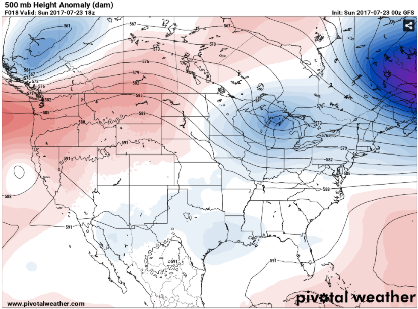
BIG PICTURE: Taking a look at the upper air setup, we see primarily zonal flow (west to east winds) up at about thirty thousand feet plus. Coming down toward the ground, at around 18,000 feet, we have a ridge west/trough east setup, and all of the weather makers coming on-shore via the Pacific Northwest immediately get re-routed up through Canada and then slide down the back of the ridge...

The blue shading over Michigan indicates an upper disturbance that came down the back side of the ridge via the Dakotas, Minnesota, and Wisconsin. Again, while some severe weather is possible, the better chances of this should remain north of us, I would say from St. Johns north is where the action would be. We'll have to see how the fine details set up though - any boundaries and such over the state, the amount of daytime heating, these kind of things.
DETAILS, DETAILS: Any shower or thunderstorm activity appears to be most likely to start sometime after 2 pm. The main body of the storms should slide well north. I would think that way up by the international border is the best bet.
AFTER THE FRONT MOVES BY: We'll see cooler, more comfortable conditions with readings in the upper 70's to lower 80's for a couple of days before the warmer weather moves back into Michigan on Wednesday, which also lines up with our next credible chance at some showers and storms. Looking down the line, forecast model data is suggesting that we will start August not in the dog days pattern,, with lower dew point values and readings holding in the lower 80's. In other words, seasonable to start the tail end of summer 2017.
Here's the forecast for South Central Michigan including Jackson, Michigan Center, and Springport:
Tonight - More clouds than stars, seasonably mild, low near 66.
Sunday - AM sunshine, clouds increase as the day progresses, PM showers and storms developing, some of these could be severe. High 87.
Sunday Night - Skies clearing slowly, any rain in the area should be gone around 11 PM. Lows near 63.
Monday - Mainly clear and cooler. High 78.
Tuesday - Continued mostly sunny and comfortable. High 81.
Wednesday - Clouds on the increase as the day progresses, some PM showers and perhaps an isolated or widely scattered thunderstorm. Warmer, high 86.
Thursday - Mixed sunshine and perhaps a couple of widely scattered showers, a touch cooler. High 82.
Friday - Sunny and pleasant. High 81.
There's your forecast, have a great one!
We'll see some changes in the weather pattern over the next day or two, but we need to get through a period of potentially rough weather first. Let's dive in and have a quick look at it.
SLIGHT SEVERE RISK TODAY: We note that the Storm Prediction Center has placed all of lower Michigan into a risk category of some type. Here in South Central Michigan, we see the standard "slight" risk for severe weather...

And a "marginal" risk identified for the northern part of the Lower Peninsula and the eastern Upper Peninsula. The main threat would be damaging wind, marginally severe hail, and some heavy downpours. I am NOT seeing where we would have tornado issues to worry about. I would be close to good source of weather information tomorrow afternoon though.
BIG PICTURE: Taking a look at the upper air setup, we see primarily zonal flow (west to east winds) up at about thirty thousand feet plus. Coming down toward the ground, at around 18,000 feet, we have a ridge west/trough east setup, and all of the weather makers coming on-shore via the Pacific Northwest immediately get re-routed up through Canada and then slide down the back of the ridge...
The blue shading over Michigan indicates an upper disturbance that came down the back side of the ridge via the Dakotas, Minnesota, and Wisconsin. Again, while some severe weather is possible, the better chances of this should remain north of us, I would say from St. Johns north is where the action would be. We'll have to see how the fine details set up though - any boundaries and such over the state, the amount of daytime heating, these kind of things.
DETAILS, DETAILS: Any shower or thunderstorm activity appears to be most likely to start sometime after 2 pm. The main body of the storms should slide well north. I would think that way up by the international border is the best bet.
AFTER THE FRONT MOVES BY: We'll see cooler, more comfortable conditions with readings in the upper 70's to lower 80's for a couple of days before the warmer weather moves back into Michigan on Wednesday, which also lines up with our next credible chance at some showers and storms. Looking down the line, forecast model data is suggesting that we will start August not in the dog days pattern,, with lower dew point values and readings holding in the lower 80's. In other words, seasonable to start the tail end of summer 2017.
Here's the forecast for South Central Michigan including Jackson, Michigan Center, and Springport:
Tonight - More clouds than stars, seasonably mild, low near 66.
Sunday - AM sunshine, clouds increase as the day progresses, PM showers and storms developing, some of these could be severe. High 87.
Sunday Night - Skies clearing slowly, any rain in the area should be gone around 11 PM. Lows near 63.
Monday - Mainly clear and cooler. High 78.
Tuesday - Continued mostly sunny and comfortable. High 81.
Wednesday - Clouds on the increase as the day progresses, some PM showers and perhaps an isolated or widely scattered thunderstorm. Warmer, high 86.
Thursday - Mixed sunshine and perhaps a couple of widely scattered showers, a touch cooler. High 82.
Friday - Sunny and pleasant. High 81.
There's your forecast, have a great one!
Subscribe to:
Posts (Atom)