We'll see some changes in the weather pattern over the next day or two, but we need to get through a period of potentially rough weather first. Let's dive in and have a quick look at it.
SLIGHT SEVERE RISK TODAY: We note that the Storm Prediction Center has placed all of lower Michigan into a risk category of some type. Here in South Central Michigan, we see the standard "slight" risk for severe weather...

And a "marginal" risk identified for the northern part of the Lower Peninsula and the eastern Upper Peninsula. The main threat would be damaging wind, marginally severe hail, and some heavy downpours. I am NOT seeing where we would have tornado issues to worry about. I would be close to good source of weather information tomorrow afternoon though.
BIG PICTURE: Taking a look at the upper air setup, we see primarily zonal flow (west to east winds) up at about thirty thousand feet plus. Coming down toward the ground, at around 18,000 feet, we have a ridge west/trough east setup, and all of the weather makers coming on-shore via the Pacific Northwest immediately get re-routed up through Canada and then slide down the back of the ridge...
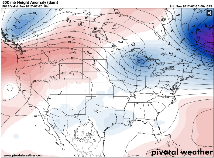
The blue shading over Michigan indicates an upper disturbance that came down the back side of the ridge via the Dakotas, Minnesota, and Wisconsin. Again, while some severe weather is possible, the better chances of this should remain north of us, I would say from St. Johns north is where the action would be. We'll have to see how the fine details set up though - any boundaries and such over the state, the amount of daytime heating, these kind of things.
DETAILS, DETAILS: Any shower or thunderstorm activity appears to be most likely to start sometime after 2 pm. The main body of the storms should slide well north. I would think that way up by the international border is the best bet.
AFTER THE FRONT MOVES BY: We'll see cooler, more comfortable conditions with readings in the upper 70's to lower 80's for a couple of days before the warmer weather moves back into Michigan on Wednesday, which also lines up with our next credible chance at some showers and storms. Looking down the line, forecast model data is suggesting that we will start August not in the dog days pattern,, with lower dew point values and readings holding in the lower 80's. In other words, seasonable to start the tail end of summer 2017.
Here's the forecast for South Central Michigan including Jackson, Michigan Center, and Springport:
Tonight - More clouds than stars, seasonably mild, low near 66.
Sunday - AM sunshine, clouds increase as the day progresses, PM showers and storms developing, some of these could be severe. High 87.
Sunday Night - Skies clearing slowly, any rain in the area should be gone around 11 PM. Lows near 63.
Monday - Mainly clear and cooler. High 78.
Tuesday - Continued mostly sunny and comfortable. High 81.
Wednesday - Clouds on the increase as the day progresses, some PM showers and perhaps an isolated or widely scattered thunderstorm. Warmer, high 86.
Thursday - Mixed sunshine and perhaps a couple of widely scattered showers, a touch cooler. High 82.
Friday - Sunny and pleasant. High 81.
There's your forecast, have a great one!
No comments:
Post a Comment