Good Evening!
The temperatures have started to fall as advertised, and the rains are working into the area. Any place that is dry now will not be in the next hour or so. A couple of wrinkles have been added to the mix:
WINTER WEATHER: A Winter Weather Advisory has been posted by the National Weather Service until 11 AM tomorrow for Calhoun, Jackson, Eaton, Ingham and Clinton counties. What's expected to happen is that as temperatures fall below freezing tonight, rain will change to freezing rain, then to light snow. Icing will be an issue also. As much as three-tenths of an inch of ice is possible in some areas by daybreak, with around an inch of snow on the high side throughout the area.
FLOODING: The National Weather Service has also issued a Flood Watch for Branch, Hillsdale, Lenawee, Washtenaw and Livingston Counties until 10 AM tomorrow. Temperatures in this part of the state are expected to remain sufficiently above freezing that steady moderate to heavy rain will be the precipitation mode, and some flooding or flash flooding is possible.
If you are in the far southeastern part of the South Zone, please watch for rain/flooding and fog tonight. The rest of the blog needs to look out for rain changing over.
We'll keep monitoring the situation and update as needed.
Saturday, January 12, 2013
FLOOD WATCH
The National Weather Service has issued a Flood Watch until 10 AM Sunday for Hillsdale, Washtenaw, Livingston and Lenawee Counties, due to heavy rain associated with a low pressure system and cold front heading into the area. Heavy rains develop tonight, 1 to 2 inches possible in southeastern Michigan, and this combined with snowmelt could pose a problem.
WINTER WEATHER ADVISORY
The National Weather Service has issued a Winter Weather Advisory for Jackson, Clinton, Ingham, Eaton and Calhoun counties starting at 10 PM tonight. Rain changes over to freezing rain and snow showers thus creating slippery driving conditions. Use caution if traveling!
So Long Spring Preview....
Good Morning!
Enjoy the spring weather while we have it, because once the temperature starts sliding backward, we don't see this mild weather again anytime soon. Let's dive right into it while it's warm (pun intended).
SUMMARY: Unseasonably mild air is in place over the area right now, and we have a surface set to make tracks this direction from the southwest. It will track right over Illinois, Indiana and Kentucky, with the core of it sliding into far southeastern Michigan and northwest Ohio. Adrian, Temperance, Toledo. That part of the world. A couple of peeks of sun mix in with the clouds, then we get into the precipitation later today and into tonight. Temperatures run 20+ degrees above average for this time of year, and I could see a record being threatened. Just as an FYI, record high this date for Jackson is 59 degrees, set over a century ago in 1898! Lansing's record high this date is 62, in 1890.
Once we get through today and tonight, we drop back to reasonable temperatures, topping out in the mid 30's. A cold polar air mass finally elbows it's way into the area...
This may force temperatures into the 20's on occasion, but you have to understand that our average according to climatology is 30 degrees, so even mid 30's is above average. We'll take it!
PRECIPITATION: We start off with some sprinkles later today that fill in and become rain showers, then we change to snow showers as the mercury falls over the next 24 hours. With the moisture in the air, also expect some fog about this evening, so use caution as you drive. After that, not really much chance of anything until hump day next week.
Here's a look at the forecast for Jackson and surrounding areas including Rives Junction and Michigan Center:
Today, mainly cloudy skies, perhaps a peek or two of sun, afternoon showers develop, unseasonably mild still, high near 57. Winds swing from southwest to NW 5-10 MPH.
Tonight, cloudy with scattered to numerous showers, temperatures fall sharply to a low near 35, winds NW 8-15 MPH.
Sunday, overcast, plenty of showers through early afternoon with maybe a bit of snow mixing in, high 38. Wind W 8-15 MPH.
Sunday night, clouds thin out as the night progresses, giving us a view of some stars, seasonably cold with lows down to 19. Winds W 9-16 will keep wind chills in or near single digits.
The new work week on Monday brings partly to mostly sunny skies, colder, high 30.
Tuesday, partly cloudy, continued seasonably chilly, high 31.
Wednesday, mostly cloudy skies, we can't rule out a few flakes or some light snow, high 35.
Thursday, skies continue mainly cloudy, we keep the mention of a flake or two around, high only 33.
Friday, still not much in the way of direct sunshine, mostly overcast, high 36.
There's a look at your forecast for the next six days, I do hope that you have a great day! Blessings.
Enjoy the spring weather while we have it, because once the temperature starts sliding backward, we don't see this mild weather again anytime soon. Let's dive right into it while it's warm (pun intended).
SUMMARY: Unseasonably mild air is in place over the area right now, and we have a surface set to make tracks this direction from the southwest. It will track right over Illinois, Indiana and Kentucky, with the core of it sliding into far southeastern Michigan and northwest Ohio. Adrian, Temperance, Toledo. That part of the world. A couple of peeks of sun mix in with the clouds, then we get into the precipitation later today and into tonight. Temperatures run 20+ degrees above average for this time of year, and I could see a record being threatened. Just as an FYI, record high this date for Jackson is 59 degrees, set over a century ago in 1898! Lansing's record high this date is 62, in 1890.
Once we get through today and tonight, we drop back to reasonable temperatures, topping out in the mid 30's. A cold polar air mass finally elbows it's way into the area...
 |
| NAM Forecast model, 4 PM Today |
 |
| NAM Forecast Model, 4 PM Sunday |
PRECIPITATION: We start off with some sprinkles later today that fill in and become rain showers, then we change to snow showers as the mercury falls over the next 24 hours. With the moisture in the air, also expect some fog about this evening, so use caution as you drive. After that, not really much chance of anything until hump day next week.
Here's a look at the forecast for Jackson and surrounding areas including Rives Junction and Michigan Center:
Today, mainly cloudy skies, perhaps a peek or two of sun, afternoon showers develop, unseasonably mild still, high near 57. Winds swing from southwest to NW 5-10 MPH.
Tonight, cloudy with scattered to numerous showers, temperatures fall sharply to a low near 35, winds NW 8-15 MPH.
Sunday, overcast, plenty of showers through early afternoon with maybe a bit of snow mixing in, high 38. Wind W 8-15 MPH.
Sunday night, clouds thin out as the night progresses, giving us a view of some stars, seasonably cold with lows down to 19. Winds W 9-16 will keep wind chills in or near single digits.
The new work week on Monday brings partly to mostly sunny skies, colder, high 30.
Tuesday, partly cloudy, continued seasonably chilly, high 31.
Wednesday, mostly cloudy skies, we can't rule out a few flakes or some light snow, high 35.
Thursday, skies continue mainly cloudy, we keep the mention of a flake or two around, high only 33.
Friday, still not much in the way of direct sunshine, mostly overcast, high 36.
Friday, January 11, 2013
Old Man Winter Returns Soon...
Good Evening!
Well, if I am going to own a busted forecast, I will certainly take this kind of a bust! The rain that came in over night moved out of the area quicker than forecast. We were partly to mostly sunny with temperatures pushing 60 in a lot of places. I should have stayed with my first read of the forecast data and left the high up at 56 today. Oh well.
SUMMARY: Some good, gentle, soaking rain moved in and out of here today, and we had clear skies. These are now clouding up, and we may see a sprinkle or two during the overnight hours. As for tomorrow, we enjoy more unseasonably mild weather. We are almost 30 degrees above average here in Jackson! Take a look at the current temperatures right now...

Look at that mild reading for the "cold" spot - 45 in Adrian at this hour. I suggest that you enjoy it, because the bottom falls out of the thermometer on Sunday, with temperatures giving back every inch of that almost 30 degree surplus and then some! Plan on temperatures not making it back to the freezing mark for at least the next week to 10 days.
PRECIPITATION: Our next weather maker comes in on Sunday as a surface low moving this way from Arkansas and Tennessee. That will kick off another round of showers that will change to a wintry mix and then all frozen precipitation as it moves this way and then heads off. Take a look at this forecast map from the GFS computer model, you can see where the cold stuff will be on Sunday afternoon...
The good news is that after Sunday, we keep snow pretty much off the table for the next week, as far as I can see. We'll have our first extended cold snap of the season as a Polar Express marches through Canada and then dives into the US.
Here's a look at the forecast for Jackson and surrounding areas including Grass Lake and Leslie:
Tonight, partly to mainly cloudy and mild, perhaps a brief stray shower, lows roll back to 42, winds SSW
5-10 MPH.
Saturday, partly to mainly cloudy skies, clouds thicken and some showers are possible in the afternoon, milder still, high near 57. SW winds work around to the NW 5-10 MPH.
Saturday night, cloudy skies, scattered showers and cooling quickly, lows near 35, winds NW 8-15 MPH.
Sunday, cloudy, scattered showers with maybe a bit of snow mixing in, high 34.
Monday, partly to mainly sunny skies, colder, temperatures top out near 30.
Tuesday, partly cloudy, high 30.
Wednesday, partly cloudy skies don't really go anywhere, we add a small chance of a few flakes or some light snow, high only 33.
Thursday, skies continue mainly cloudy, we keep the mention of a flake or two around, high only 30.
There's a look at your forecast for the next six days. I do hope that you have a great weekend! Blessings.
Well, if I am going to own a busted forecast, I will certainly take this kind of a bust! The rain that came in over night moved out of the area quicker than forecast. We were partly to mostly sunny with temperatures pushing 60 in a lot of places. I should have stayed with my first read of the forecast data and left the high up at 56 today. Oh well.
SUMMARY: Some good, gentle, soaking rain moved in and out of here today, and we had clear skies. These are now clouding up, and we may see a sprinkle or two during the overnight hours. As for tomorrow, we enjoy more unseasonably mild weather. We are almost 30 degrees above average here in Jackson! Take a look at the current temperatures right now...

Look at that mild reading for the "cold" spot - 45 in Adrian at this hour. I suggest that you enjoy it, because the bottom falls out of the thermometer on Sunday, with temperatures giving back every inch of that almost 30 degree surplus and then some! Plan on temperatures not making it back to the freezing mark for at least the next week to 10 days.
PRECIPITATION: Our next weather maker comes in on Sunday as a surface low moving this way from Arkansas and Tennessee. That will kick off another round of showers that will change to a wintry mix and then all frozen precipitation as it moves this way and then heads off. Take a look at this forecast map from the GFS computer model, you can see where the cold stuff will be on Sunday afternoon...
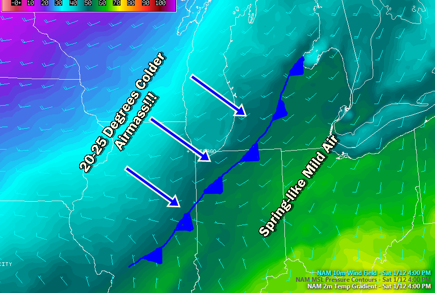 |
| NAM Forecast Model, 4 PM Saturday. Notice the sharp gradient of falling temperatures just behind where the cold front is marked here. |
The good news is that after Sunday, we keep snow pretty much off the table for the next week, as far as I can see. We'll have our first extended cold snap of the season as a Polar Express marches through Canada and then dives into the US.
Here's a look at the forecast for Jackson and surrounding areas including Grass Lake and Leslie:
Tonight, partly to mainly cloudy and mild, perhaps a brief stray shower, lows roll back to 42, winds SSW
5-10 MPH.
Saturday, partly to mainly cloudy skies, clouds thicken and some showers are possible in the afternoon, milder still, high near 57. SW winds work around to the NW 5-10 MPH.
Saturday night, cloudy skies, scattered showers and cooling quickly, lows near 35, winds NW 8-15 MPH.
Sunday, cloudy, scattered showers with maybe a bit of snow mixing in, high 34.
Monday, partly to mainly sunny skies, colder, temperatures top out near 30.
Tuesday, partly cloudy, high 30.
Wednesday, partly cloudy skies don't really go anywhere, we add a small chance of a few flakes or some light snow, high only 33.
Thursday, skies continue mainly cloudy, we keep the mention of a flake or two around, high only 30.
There's a look at your forecast for the next six days. I do hope that you have a great weekend! Blessings.
Subscribe to:
Posts (Atom)