Well, if I am going to own a busted forecast, I will certainly take this kind of a bust! The rain that came in over night moved out of the area quicker than forecast. We were partly to mostly sunny with temperatures pushing 60 in a lot of places. I should have stayed with my first read of the forecast data and left the high up at 56 today. Oh well.
SUMMARY: Some good, gentle, soaking rain moved in and out of here today, and we had clear skies. These are now clouding up, and we may see a sprinkle or two during the overnight hours. As for tomorrow, we enjoy more unseasonably mild weather. We are almost 30 degrees above average here in Jackson! Take a look at the current temperatures right now...

Look at that mild reading for the "cold" spot - 45 in Adrian at this hour. I suggest that you enjoy it, because the bottom falls out of the thermometer on Sunday, with temperatures giving back every inch of that almost 30 degree surplus and then some! Plan on temperatures not making it back to the freezing mark for at least the next week to 10 days.
PRECIPITATION: Our next weather maker comes in on Sunday as a surface low moving this way from Arkansas and Tennessee. That will kick off another round of showers that will change to a wintry mix and then all frozen precipitation as it moves this way and then heads off. Take a look at this forecast map from the GFS computer model, you can see where the cold stuff will be on Sunday afternoon...
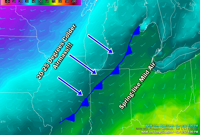 |
| NAM Forecast Model, 4 PM Saturday. Notice the sharp gradient of falling temperatures just behind where the cold front is marked here. |
The good news is that after Sunday, we keep snow pretty much off the table for the next week, as far as I can see. We'll have our first extended cold snap of the season as a Polar Express marches through Canada and then dives into the US.
Here's a look at the forecast for Jackson and surrounding areas including Grass Lake and Leslie:
Tonight, partly to mainly cloudy and mild, perhaps a brief stray shower, lows roll back to 42, winds SSW
5-10 MPH.
Saturday, partly to mainly cloudy skies, clouds thicken and some showers are possible in the afternoon, milder still, high near 57. SW winds work around to the NW 5-10 MPH.
Saturday night, cloudy skies, scattered showers and cooling quickly, lows near 35, winds NW 8-15 MPH.
Sunday, cloudy, scattered showers with maybe a bit of snow mixing in, high 34.
Monday, partly to mainly sunny skies, colder, temperatures top out near 30.
Tuesday, partly cloudy, high 30.
Wednesday, partly cloudy skies don't really go anywhere, we add a small chance of a few flakes or some light snow, high only 33.
Thursday, skies continue mainly cloudy, we keep the mention of a flake or two around, high only 30.
There's a look at your forecast for the next six days. I do hope that you have a great weekend! Blessings.
No comments:
Post a Comment