Well, time to own up to a busted forecast. Where did the snow come from? Simple. Air aloft at or below freezing, strong winds mixing that all the way down to the surface, and voila! I had precipitation in the forecast, but I wasn't thinking it would be the frozen variety. Nuts. Next?
SUMMARY: Cloudy skies right now, they stay that way for the most part today, I don't see any snow falling today that amounts to anything, but we can't rule out a stray flurry or two. We'll keep the temperatures above average, hovering right around the 40 degree mark. After Thursday, things cool down again as we get some chilly Canadian air in here; readings do not even break 30 for the weekend. Next week we get back into the mid to upper 30's part of the thermometer, and stay around there for a bit, but then changes may be in the offing...
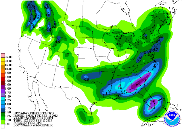
PRECIPITATION: Not much going on in the immediate future, maybe some stray flurries or a lonely shower tomorrow. Thursday a more substantial chance at some rain as a low walks across the northwest part of Michigan up by Cadillac and Traverse City. Some light rain or snow shower activity is a safe bet, I don't see it amounting to a whole lot though. I'm thinking more so rain since we'll be on the "warm" side of that system, but I'll need to see some air temperature plots to solidify that. The National Weather Service 5 day forecast backs that up...
 |
| 5 Day Precipitation Forecast |
 |
| Global Forecast System Forecast Map Valid Tuesday 1 PM |
Let's bring it closer to home and have a look at the forecast for Jackson and surrounding areas including Spring Arbor and Michigan Center...
This afternoon, cloudy skies, seasonable, perhaps a few flurries or a light shower, high 34, wind SW 6-12 MPH.
Tonight, mainly cloudy skies, perhaps a bit of clearing later, low 21. Wind SW 3-7 MPH.
Wednesday, a mix of clouds and sunshine, milder, high 38. Wind SW 5-10 MPH.
Wednesday night, some stars, clouds thicken as the night progresses, lows near 26, wind SW 5-10 MPH.
Thursday, cloudy skies, some scattered showers or perhaps snow showers high 40.
Friday, cloudy and colder, high 31.
Saturday, cloudy skies, even colder, light snow possible, high only 26.
Sunday, clouds thin as the day progresses, high 27.
Monday, partly cloudy skies, not as cold, high 37.
There's a look at your forecast for the next six days, I do hope that you have a great day! Blessings.
No comments:
Post a Comment