TEMPERATURES: We see temperatures in the
70's until midweek, when an 80 or two is likely in the area. Modeling
indicates that the late summer/early fall regime should hold for the next
several days, with temperatures running a bit below normal. The ridge trough
pattern continues, and with it, cool Canadian air. A series of shortwave
disturbances work into and through the troughs, bringing rain chances.
Cooler conditions as well, with forecast modeling suggesting 60's next
week.
RAIN: The National Weather Service is
predicting that we'll see rainfall totals around an inch for most areas in the
blog for the next five days, and that looks about right. Wednesday looks
to be the only really dry day of the next several, with the chance of scattered
showers or a roaming thunderstorm every day except Wednesday. Here's a
look at that five day forecast map for you...
 |
| 5 Day Precipitation Forecast |
This
looks about right for the next few days, the data I have looked at doesn't
suggest that the rain amounts are out of line. If anything, what you'll
see is heavier rain centered in a track from southwest to northeast, so the
west end of the South zone gets a good soaking (Branch, Calhoun, northwest
Jackson), then that tracks up and through the east end of the North zone
(Shiawassee, Livingston).
SEVERE WEATHER: Not much of that in the
outlook for south central Michigan. The Storm Prediction Center has us
under just a general risk of thunderstorms for the next two days, with a slight
risk well south today and into Pennsylvania, Delaware, Maryland, and Virginia
tomorrow.
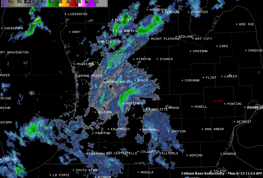
The
Grand Rapids NEXRAD has some shower activity on it, that will make it's way in
here as the day progresses. It's not as organized as it was earlier this
morning, so coverage will be uneven, as is typical this time of year.
 |
| Grand Rapids NEXRAD |
The
visible satellite is cloudy as all get out, as this current system tracks
through the area.
 |
| Visible Satellite Image |
Today, mostly cloudy skies with scattered showers, perhaps a buried thunderstorm, high 77, winds SW 5-10 MPH.
Tonight, more scattered showers, cloudy, low 57, winds SW 5-10 MPH.
Tuesday, clouds stay with us for much of the day, along with some lingering scattered showers, high 75, winds NW 6-12 MPH.
Tuesday night, clouds finally thin out and depart, leaving it mainly clear late, low of 55, winds N 5-9 MPH.
Wednesday, periods of clouds and sunshine, a very small chance of an isolated shower, breezy, high 76.
Thursday, partly sunny, breezy, warmer, a widely scattered shower or lonely thunderstorm is possible later in the day, high 79.
Friday, cloudy, a chance of some scattered showers, cooler, high 73.
Saturday, partly cloudy skies, we still can't eliminate the chance of a few scattered midday showers, high 73.
There's a look at your forecast for the next six days. I do hope that you have a great day! Blessings.
No comments:
Post a Comment