Between the moving and summer baseball, I have been SUPER BUSY! I haven't been in front of a computer since Friday! I had just enough time that day to text a one-day forecast for Friday and that was it. As soon as things settle down, I promise you we'll get back to the regular schedule. Please be patient.
I'll tell you what, a couple of days makes SO much difference! The stifling heat we have had to work through the last couple of weeks has retreated southwest back into the high southern Plains and desert, to places that are used to dealing with it. The Sun Belt and interior west are heating up to their scorching hot summertime temperatures, and here in South Central Michigan, we finally have cooled back into a much more comfy and seasonable pattern. Here's US surface temperatures at 9AM:
 |
| US Surface Temperature Map, notice the heat is back in the desert and Interior West where it typically should be in summer. |
The rain situation is still bad news; even though we did get some desperately needed precipitation in spots over the weekend, still nothing to speak of that will put a dent in the drought. That being said, it's nice to not wake to a morning temperature at or near a muggy 80 degrees! Let's do a deeper dive and see what's under the hood for the next few days...
TEMPERATURES: Seasonable. No triple digits, 90's or even upper 80's on the radar for the next several days! Finally the air conditioners get a much deserved rest in the evenings in most places! Average temperatures for this time of year run from 83-87 degrees, and our friendly GFS computer forecast model likes 85 as the warmest daytime high right through the weekend. The shorter range NAM computer model is running a degree or two warmer, but they both are in agreement that it stays seasonable. Here's another bonus to this true northwesterly flow that has re-established itself. With the heat dome retreating southwest as I said, the air coming from north of the border is not only cooler, but drier as well. This is truly a cooler Canadian air regime we are set up in now, and you'll love it I'm sure! Here's a bird's eye view of how the heat has moved away from us, this is about 18,000 feet up on the GFS computer model:
 |
| GFS Model Map showing the ridge with the hot air west, and a trough with cooler air east, we are in the cool northwest flow on the back side of the ridge. |
Looking into the crystal ball for almost 2 weeks out, allegedly the heat will return, but not as intense as this last heat wave. I wouldn't even worry about it at this point, as it's still WAY too early to hang a hat on anything the computer models say that far out.
RAIN: The trade off for all this gorgeous weather is that we miss out on some much needed rain in the area. The National Weather Service has us basically bone dry for the next five days, and I buy that solution. Cool, dry air from Canada is here, with the warmer, moister air boundary well off to the south adds up to not much to bother the atmosphere and fire off showers, so keep the sprinklers going. Here's a look at a very dry five day rain forecast map from the NWS:
 |
| 5 Day Rain Forecast Map from the National Weather Service |
SEVERE WEATHER: Nothing on tap in Michigan for the next three days according to the Storm Prediction Center. Today we have just a "general" risk of plain vanilla thunderstorms and that's it. For my money, I would frankly be a little shocked if we get any really organized storms moving, but any storms that do manage to get going in this dry air will be isolated "hit and run" storms. Here's the forecast map for today only from the SPC, as days two and three have nothing on the board for us.
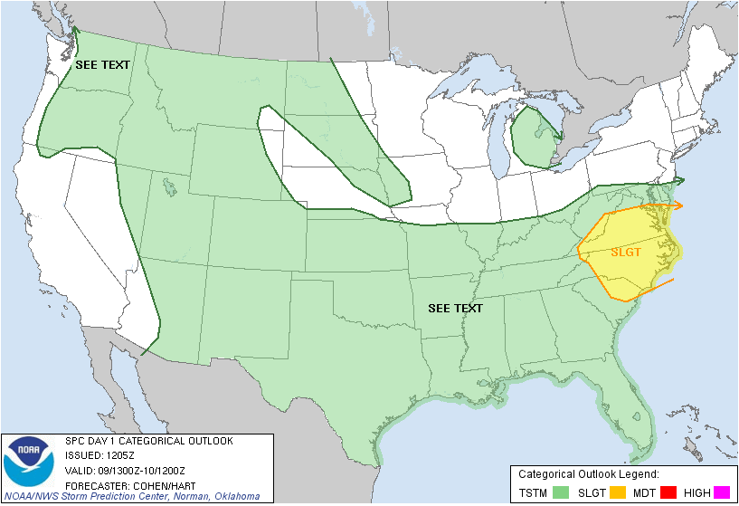 |
| SPC Day 1 Forecast Map |
Grand Rapids NEXRAD has nothing of interest unless you like looking at ground clutter near the radar itself, and the visible satellite is dotted by just a few high clouds in the area.
 |
| Visible Satellite Image |
Here's the forecast for Jackson and surrounding communities including Pleasant Lake and Spring Arbor:
Today, sunny and pleasant, high 84, winds ESE calm to 6 MPH.
Tonight, clear skies, a good stargazing night, lows roll back to 56, winds NE 3-8 MPH.
Tuesday, continued sunny and seasonable, high 83, winds E calm to 6 MPH.
Tomorrow night, still mostly clear, a few passing clouds will float by, low of 58, winds E calm to 5 MPH.
Wednesday, rewind and replay Tuesday, plenty of sun, seasonably warm, high 83.
Thursday, mainly clear, perhaps a few clouds throughout the day, a bit warmer, high of 85.
Friday, still sunny, just a few clouds here and there during the day, high 84.
Saturday, a mix of clouds and sunshine, a small chance of an isolated shower during the afternoon, high 85.
There's a winner of a six-day forecast for you, I do hope your Monday is a great one! Blessings.
No comments:
Post a Comment