Wednesday, August 13, 2014

Cool & Quiet Until The Weekend...

Good Afternoon!

Lunchtime is winding down here in the Rose City and probably for a lot of folks in the Eastern time zone!  Bright blue skies in Michigan with readings just into the 70's in most places, thanks to a cool, dry Canadian air mass that has settled in across the area.  That's the setup for some quiet weather the next few days.  The kids practicing to kick off their high school football and soccer seasons soon won't have to worry about heat for awhile.  Let's take a closer look!

CLEAR & DRY:  Taking a look at the enhanced Water Vapor satellite image, just look at that dry air from Texas working through the Southeast and curling back up into the lower Ohio Valley!
 

That means sunshine and seasonable readings, if a bit cool for this time of year.  I don't see anything on the horizon rain-wise until Saturday afternoon and evening at the earliest.  Low dew point values will keep things comfy and refreshing for the most part.  Average temperature in this part of the world is right around 80, and we stay below that until early next week if the computers have it right, and so far, they all seem to point in that direction!

WEEKEND RAIN, RACE LOOKS OK FOR NOW:  Taking a look at the forecast models, the Canadian high pressure that we'll be parked under for the next couple of days gets bothered by a bit of an upper disturbance, then it slides off to the east, Friday, allowing a low to march due east from out of the central Plains.  We'll see clear skies to start, then some clouds work during the overnight into Saturday. Since there's no Nationwide race at Michigan International Speedway this trip, the rain may dampen things for the campers there, but I don't see it bothering the Pure Michigan 400 on Sunday.  The low should slide underneath us and track across north central Indiana.  The forecast has the rain moving through on Saturday and being done for the most part by the time church is over on Sunday, which brings you right up to the race.

DRY AFTER WEDNESDAY:  The next chances at rain come mid week after we get the Saturday/Sunday deal through and out of here.  Temperatures look to stay in the low 80's, so seasonable if a bit cool is still the look for us in the area.  Let's see what the rainfall totals look like the next five days:


This bears out my feeling that we shouldn't see a whole lot of rain, and that the race should be fine Sunday - only a half inch expected during the next five days on the high side.

NO SEVERE EXPECTED:  In fact, no thunderstorms of any kind are expected the next three days in Michigan according to the Storm Prediction Center.  The closest they get to us is on Friday, when they show up across lake Michigan in Wisconsin.

Here's the forecast:


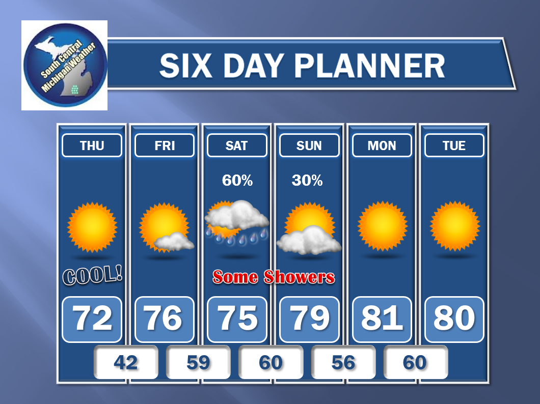
And the extended Six day...


I hope you have a wonderful day!  Blessings.

I Will Be In And Out For Awhile...

Dear Friends & Readers:

A lot going on in Forecaster Mike's world, and I wish I could say it was all good.

Last Thursday evening, the lady who is basically my mother-in-law was found unresponsive and basically near death in her apartment.  She was rushed by ambulance to the local hospital and is still in the Critical Care Unit.  I am thankful to say that she has improved a bit since she was admitted, but she still has a long road to travel.

She had septic shock, pneumonia, and extreme acute diabetic shock from not taking her insulin and watching her diabetes as she should.  And to add insult to injury, she was recently diagnosed with cancer and the docs are trying to figure out what the scoop is with that as well.

Combine that with the fact that I have to move by the end of this month, and the search for a place is complicated by 1) now needing 3 bedrooms instead of 2; 2) at least one pet, possibly two having to go with (even though the puppy is a registered companion dog in training); 3) I have had such a rough go financially this last year, that I've fallen behind on bills, even working what amount to two jobs, so no one wants to touch me for another place. 4)  I'm pretty sure I've got something going on with me health-wise, but I can't spare the time just now to get looked over, and possibly have to sit out for awhile from keeping my fam in what they need to live.  It's getting close to time for my daughter to start school.

So - long story short, I'll be more out than in, except in the case of severe weather.  I will post on the Facebook page that goes with the South Central Michigan Weather blog, as I can do that from my phone. And that's another thing; the whole deal with Facebook now mandating you use their Messenger app for instant messages, which demands too much access to your smartphone in my opinion - I'm debating quitting Facebook altogether and going with Google +.

Anyway - please pray for and/or send a good thought towards Nana - her name is Dianna, and for the family, so that we don't end up out on the streets Labor Day weekend.

Forecast on the way.

Cheers.

Mike


Thursday, August 7, 2014

Quick Look At A Quiet Weekend...

Good Morning!

Not a whole lot to talk about weather wise in this part of the world.  Fairly quiet for the next few days, with all of the action elsewhere.  Let's talk...

FAIRLY LAID BACK SETUP:  Looking at the Water Vapor satellite imagery, we note some very dry air over lower Michigan, putting the kibosh on rain chances here for now.  The upper air setup is a moderate trough west, some weak ridging over the central US, and another moderate trough east.  The result?  most of the storm action is confined to the Plains and the Mississippi/Ohio valleys.  Not seeing any real rain in this part of the world before early next week.

NO ORGANIZED SEVERE WEATHER EXPECTED:  At the moment, the Storm Prediction Center has no bona fide risks drawn on any of their maps for the next three days.  There are some "see text" spots on the maps, these are for pop-up or clustered thunderstorms with locally heavy rain, marginally severe straight-line winds, and perhaps some small hail.

FAIRLY MILD TEMPERATURES FOR US:  The dry air will keep dew point values down, and the weak trough we're under will keep a northerly component to the wind, thus limiting the intrusion of warm, humid Gulf air.  All of that keeps readings seasonable, with 83 being the high side until you get into an urban area like Lansing or Ann Arbor/Detroit, where the heat island effect might cause them to post an 84 or 85. Still, comfy with low humidity.  We'll keep those readings around until Sunday evening/Monday, when our next credible shot at showers and thunderstorms drops the mercury back into the upper 70's.  Still no sign of those dog days of August yet, and we'll take it!

RAIN CHANCES:  Basically non-existent through Sunday.  We'll introduce some clouds as early as Saturday evening, but I'm hanging my hat on the Sunday solution presented by the forecast models.  That means increasing clouds during the day, with the chance of a few scattered PM showers or a storm Sunday evening and into Monday.  I'm watching to see how the computers refine their take on this, but I'm seeing enough run to run consistency between the models that a mention is warranted.  4 in 10 for any one spot getting some rain fits the bill at this time.

OK, here's the forecast for you:

Today - Sunny and seasonably pleasant - High 81.  Winds variable, calm to 5 MPH.

Tonight - Moonlit and pleasant - Low 55.  Winds NNW swinging to NNE calm to 5 MPH.

Friday - Continued sunny and summery.  A touch warmer - High 83.  Winds turning ESE 2-7 MPH.

Saturday - Mostly sunny, some clouds start filtering in during the afternoon.  Warm - High 83.

Sunday - Becoming mostly cloudy by evening, a spotty PM shower can't be ruled out - High 82.

Monday - Variably cloudy, some scattered showers or perhaps a roaming thunderstorm.  A touch cooler - High 79.

Tuesday - Clearing skies, mostly sunny by afternoon.  Seasonably warm - High 80.

Wednesday - Sunny, a touch cooler - High 78.

There's a look at what's going on and your forecast.  I hope that you have a wonderful day!  Blessings.

Monday, August 4, 2014

Severe Thunderstorm Warning - Washtenaw - CANCELED

This Warning has been canceled by the National Weather Service as the storm has weakened to sub-severe strength and is not an immediate threat to life and property.

Severe Thunderstorm Warning - Washtenaw

THE NATIONAL WEATHER SERVICE IN DETROIT/PONTIAC HAS ISSUED A
* SEVERE THUNDERSTORM WARNING FOR...
NORTHEASTERN WASHTENAW COUNTY IN SOUTHEAST MICHIGAN...
* UNTIL 530 PM EDT
* AT 422 PM EDT...A SEVERE THUNDERSTORM WAS LOCATED NEAR DIXBORO...
AND MOVING EAST AT 10 MPH.
HAZARD...QUARTER SIZE HAIL.
SOURCE...RADAR INDICATED.
IMPACT...DAMAGE TO VEHICLES IS EXPECTED.
* THE SEVERE THUNDERSTORM WILL BE NEAR...
SALEM AROUND 455 PM EDT.
THE WARNING INCLUDES AREAS SURROUNDING THESE LOCATIONS...
DIXBORO...            YPSILANTI...          SALEM...