The Storm Prediction Center in Norman, Oklahoma has issued a Severe Thunderstorm b Watch until 9 PM for all counties covered by South Central Michigan Weather. Small hail, wind up to 60 MPH, and heavy downpours are possible. I'll be monitoring and will post as necessary.
Friday, September 5, 2014

Tuesday, August 26, 2014
SEVERE THUNDERSTORM WARNING - EATON, INGHAM, JACKSON, WASHTENAW, SHIAWASSEE, LIVINGSTON

60 MPH winds with these storms, especially in Ingham County.
Monday, August 25, 2014
SEVERE THUNDERSTORM WARNING EATON, CLINTON
The National Weather Service In Grand Rapids Has Issued A
* Severe Thunderstorm Warning For...
Southwestern Clinton County In South Central Michigan...
Northeastern Eaton County In South Central Michigan...
Southeastern Ionia County In South Central Michigan...
* Until 315 Pm Edt
* At 234 Pm Edt...A Severe Thunderstorm Was Located Near Sunfield...
And Moving East At 30 Mph.
Hazard...60 Mph Wind Gusts And Penny Size Hail.
Source...Radar Indicated.
Impact...Expect Damage To Roofs...Siding And Trees.
* Locations Impacted Include...
Grand Ledge... Waverly... Mulliken...
Dimondale... Sunfield... Wacousta...
Eagle... Kent Corners... Frost Corners...
Delta Mills... Hoytville... Millett...
...0.75in Wind...60mph
Thursday, August 21, 2014
Summer? Oh, There You Are...
Good Morning!
Weather more typical of August has finally made it into Michigan. Hot weather with humid conditions for the next few days, with a decent chance of afternoon showers and storms each day for the next few. Let's have a look...
PATTERN RESET: The upper air pattern has finally sifted into something you'd expect for this time of year. Even though it's technically not the dog days of August as Sirius is in the wrong position, we'll still have plenty of heat and moisture to deal with. Sub-tropical ridging with plenty of Gulf moisture is evident across the eastern 2/3 of the US. Add the jet stream turning southeast right near us, and you have plenty of quality air for disturbances working through the mean flow to kick off showers and storms!
WARMER WEATHER: Temperatures in the area tend to stay right around 79 this time of year. You can forget about anything below 80 for the next week or so, and I would not at all be shocked to see a 90 here and there, with moderate to high dew point values making it steamy. I'm not seeing an 80 in the cards again until next Thursday at the earliest! Readings should fall in the 83-89 range across the area, and the high dew point values will yield heat index values from 85 to 90!
CLOUDS AND RAINDROPS: The other big change from the last several days is the chances of rain. I expect more clouds than sunshine in the area for the next week, and given the conditions, rain should not be a surprise to anyone. Computer data is suggesting a minimum 3 in 10 shot at rain right through the forecast window, so needless to say, each day will have the mention of some scattered showers and possibly a few thunderstorms.
SEVERE WEATHER?: The Storm Prediction Center does have part of the blog in the "slight" risk category for severe thunderstorms today. SPC says strong straight-line winds and hail are the primary threats. Looking at the map, it's the far southwest part of the blog that is in play. Draw a diagonal line from the northwest to the southeast corner of Calhoun county. Extend that line into Hillsdale county, same thing.
Just the extreme southwest corner of Lenawee county is in, All of Branch county is in. If I didn't mention your county, you're out...for now. That being said, don't expect storms to obey the lines drawn on the map. Be ready for the possibility of strong to severe storms this afternoon. We'll know more here about 2 PM EDT.
FORECAST: Today - cloudy skies, humid, an even money (50/50) shot at scattered to numerous showers and thunderstorms this afternoon and evening. High 85. Wind WSW calm to 5 MPH.
Tonight - continued cloudy and muggy, still the chance of scattered showers and storms, lows near 66. Wind SW 3 -8 MPH.
Friday - mainly cloudy, 60% chance of scattered to numerous showers and thunderstorms. Sticky, high 88, heat indexes could get to 90 or better. Wind SW 4-8 MPH.
Friday Night - Continued warm and sultry, some breaks in the clouds lower rain chances to 25%. Lows roll back to near 67, wind SW Calm to 6 MPH.
Saturday - some broken sunshine in spots, a touch cooler but still humid, an afternoon or evening shower or storm can't be ruled out. High 85. Wind SW Calm to 6 MPH.
Sunday - a replay of Saturday. Clouds do increase in the afternoon, high 86. Still the chance of a few PM showers or storms.
Monday - Partly sunny, warm and humid. 30% chance of scattered afternoon showers and storms, high 88.
Tuesday - More mixed sunshine, more PM showers and a couple of storms in spots, high 85.
Wednesday - Periods of clouds and sun, a 30% chance of showers or a storm, high 86.
There's your forecast for the next six days. I hope you have a great Thursday! Blessings.
Weather more typical of August has finally made it into Michigan. Hot weather with humid conditions for the next few days, with a decent chance of afternoon showers and storms each day for the next few. Let's have a look...
PATTERN RESET: The upper air pattern has finally sifted into something you'd expect for this time of year. Even though it's technically not the dog days of August as Sirius is in the wrong position, we'll still have plenty of heat and moisture to deal with. Sub-tropical ridging with plenty of Gulf moisture is evident across the eastern 2/3 of the US. Add the jet stream turning southeast right near us, and you have plenty of quality air for disturbances working through the mean flow to kick off showers and storms!
WARMER WEATHER: Temperatures in the area tend to stay right around 79 this time of year. You can forget about anything below 80 for the next week or so, and I would not at all be shocked to see a 90 here and there, with moderate to high dew point values making it steamy. I'm not seeing an 80 in the cards again until next Thursday at the earliest! Readings should fall in the 83-89 range across the area, and the high dew point values will yield heat index values from 85 to 90!
CLOUDS AND RAINDROPS: The other big change from the last several days is the chances of rain. I expect more clouds than sunshine in the area for the next week, and given the conditions, rain should not be a surprise to anyone. Computer data is suggesting a minimum 3 in 10 shot at rain right through the forecast window, so needless to say, each day will have the mention of some scattered showers and possibly a few thunderstorms.
SEVERE WEATHER?: The Storm Prediction Center does have part of the blog in the "slight" risk category for severe thunderstorms today. SPC says strong straight-line winds and hail are the primary threats. Looking at the map, it's the far southwest part of the blog that is in play. Draw a diagonal line from the northwest to the southeast corner of Calhoun county. Extend that line into Hillsdale county, same thing.
Just the extreme southwest corner of Lenawee county is in, All of Branch county is in. If I didn't mention your county, you're out...for now. That being said, don't expect storms to obey the lines drawn on the map. Be ready for the possibility of strong to severe storms this afternoon. We'll know more here about 2 PM EDT.
FORECAST: Today - cloudy skies, humid, an even money (50/50) shot at scattered to numerous showers and thunderstorms this afternoon and evening. High 85. Wind WSW calm to 5 MPH.
Tonight - continued cloudy and muggy, still the chance of scattered showers and storms, lows near 66. Wind SW 3 -8 MPH.
Friday - mainly cloudy, 60% chance of scattered to numerous showers and thunderstorms. Sticky, high 88, heat indexes could get to 90 or better. Wind SW 4-8 MPH.
Friday Night - Continued warm and sultry, some breaks in the clouds lower rain chances to 25%. Lows roll back to near 67, wind SW Calm to 6 MPH.
Saturday - some broken sunshine in spots, a touch cooler but still humid, an afternoon or evening shower or storm can't be ruled out. High 85. Wind SW Calm to 6 MPH.
Sunday - a replay of Saturday. Clouds do increase in the afternoon, high 86. Still the chance of a few PM showers or storms.
Monday - Partly sunny, warm and humid. 30% chance of scattered afternoon showers and storms, high 88.
Tuesday - More mixed sunshine, more PM showers and a couple of storms in spots, high 85.
Wednesday - Periods of clouds and sun, a 30% chance of showers or a storm, high 86.
There's your forecast for the next six days. I hope you have a great Thursday! Blessings.
Wednesday, August 13, 2014
Cool & Quiet Until The Weekend...
Good Afternoon!
Lunchtime is winding down here in the Rose City and probably for a lot of folks in the Eastern time zone! Bright blue skies in Michigan with readings just into the 70's in most places, thanks to a cool, dry Canadian air mass that has settled in across the area. That's the setup for some quiet weather the next few days. The kids practicing to kick off their high school football and soccer seasons soon won't have to worry about heat for awhile. Let's take a closer look!
CLEAR & DRY: Taking a look at the enhanced Water Vapor satellite image, just look at that dry air from Texas working through the Southeast and curling back up into the lower Ohio Valley!

That means sunshine and seasonable readings, if a bit cool for this time of year. I don't see anything on the horizon rain-wise until Saturday afternoon and evening at the earliest. Low dew point values will keep things comfy and refreshing for the most part. Average temperature in this part of the world is right around 80, and we stay below that until early next week if the computers have it right, and so far, they all seem to point in that direction!
WEEKEND RAIN, RACE LOOKS OK FOR NOW: Taking a look at the forecast models, the Canadian high pressure that we'll be parked under for the next couple of days gets bothered by a bit of an upper disturbance, then it slides off to the east, Friday, allowing a low to march due east from out of the central Plains. We'll see clear skies to start, then some clouds work during the overnight into Saturday. Since there's no Nationwide race at Michigan International Speedway this trip, the rain may dampen things for the campers there, but I don't see it bothering the Pure Michigan 400 on Sunday. The low should slide underneath us and track across north central Indiana. The forecast has the rain moving through on Saturday and being done for the most part by the time church is over on Sunday, which brings you right up to the race.
DRY AFTER WEDNESDAY: The next chances at rain come mid week after we get the Saturday/Sunday deal through and out of here. Temperatures look to stay in the low 80's, so seasonable if a bit cool is still the look for us in the area. Let's see what the rainfall totals look like the next five days:

This bears out my feeling that we shouldn't see a whole lot of rain, and that the race should be fine Sunday - only a half inch expected during the next five days on the high side.
NO SEVERE EXPECTED: In fact, no thunderstorms of any kind are expected the next three days in Michigan according to the Storm Prediction Center. The closest they get to us is on Friday, when they show up across lake Michigan in Wisconsin.
Here's the forecast:


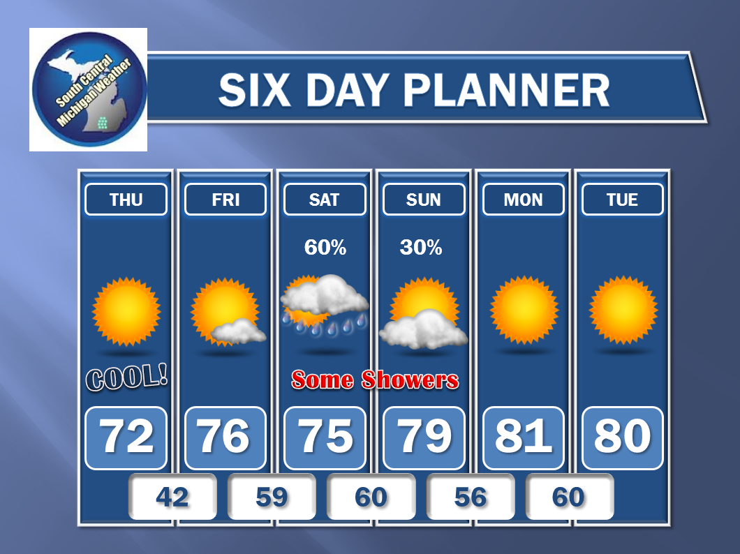
And the extended Six day...
I hope you have a wonderful day! Blessings.
Lunchtime is winding down here in the Rose City and probably for a lot of folks in the Eastern time zone! Bright blue skies in Michigan with readings just into the 70's in most places, thanks to a cool, dry Canadian air mass that has settled in across the area. That's the setup for some quiet weather the next few days. The kids practicing to kick off their high school football and soccer seasons soon won't have to worry about heat for awhile. Let's take a closer look!
CLEAR & DRY: Taking a look at the enhanced Water Vapor satellite image, just look at that dry air from Texas working through the Southeast and curling back up into the lower Ohio Valley!
That means sunshine and seasonable readings, if a bit cool for this time of year. I don't see anything on the horizon rain-wise until Saturday afternoon and evening at the earliest. Low dew point values will keep things comfy and refreshing for the most part. Average temperature in this part of the world is right around 80, and we stay below that until early next week if the computers have it right, and so far, they all seem to point in that direction!
WEEKEND RAIN, RACE LOOKS OK FOR NOW: Taking a look at the forecast models, the Canadian high pressure that we'll be parked under for the next couple of days gets bothered by a bit of an upper disturbance, then it slides off to the east, Friday, allowing a low to march due east from out of the central Plains. We'll see clear skies to start, then some clouds work during the overnight into Saturday. Since there's no Nationwide race at Michigan International Speedway this trip, the rain may dampen things for the campers there, but I don't see it bothering the Pure Michigan 400 on Sunday. The low should slide underneath us and track across north central Indiana. The forecast has the rain moving through on Saturday and being done for the most part by the time church is over on Sunday, which brings you right up to the race.
DRY AFTER WEDNESDAY: The next chances at rain come mid week after we get the Saturday/Sunday deal through and out of here. Temperatures look to stay in the low 80's, so seasonable if a bit cool is still the look for us in the area. Let's see what the rainfall totals look like the next five days:
This bears out my feeling that we shouldn't see a whole lot of rain, and that the race should be fine Sunday - only a half inch expected during the next five days on the high side.
NO SEVERE EXPECTED: In fact, no thunderstorms of any kind are expected the next three days in Michigan according to the Storm Prediction Center. The closest they get to us is on Friday, when they show up across lake Michigan in Wisconsin.
Here's the forecast:
And the extended Six day...
I hope you have a wonderful day! Blessings.
Subscribe to:
Posts (Atom)