Saturday, April 14, 2012

SPC Updates Day 2 Forecast...

Good Evening!

While all of the weather enthusiasts and severe weather fans have their attention directed out to the evolving severe weather event in the Plains, we still have a state right here that needs some attention too.  Plus a couple of developments have occurred since the AM forecast.

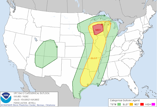
The big change is a revision of the Day 2 forecast map by the Storm Prediction Center.  Take a look at this updated map:


Notice the new "moderate" risk covering pretty much all of Wisconsin, and the "slight" risk that has crept across Lake Michigan and covers the south half of the upper peninsula and a sliver of northwestern lower Michigan.  That "slight" risk goes all the way down into the ArkLaTex.  That wasn't in the SPC forecast this morning.

That moderate risk is out in front of the deep surface low that is making all the ruckus in the Plains today.  Computer models are all liking a track northwest right up through Wisconsin, and upper Michigan, including the northern part of the Lower Peninsula tomorrow into Monday.  Models are also showing good upper level support for showers and thunderstorms in the area.  We'll know this evening how much this impacts the forecast for next week.

The bulk of the rain is staying south of Michigan for now, and that looks to hold for at least a few more hours.  Do not be surprised to see showers and storms re-develop tonight into tomorrow.

More to come later!
Storm Prediction Center has upgraded the storm risk over Wisconsin to "Moderate" for tomorrow. Details coming up later today on the blog.

Rain...Rinse...Repeat

Good Morning!

I certainly hope my day today goes better than yesterday!  Anyway, we’ve got a lot to talk about, so no dwelling on the past, let’s jump into it.  Be advised that today the posting will deviate somewhat from the usual format.

SEVERE WEATHER:  All eyes are on the Great Plains today, as the Storm Prediction Center is forecasting a high likelihood of a tornado outbreak for later today into tonight.  Here’s today’s map from SPC.  As always, the map isn’t valid until 8AM each day…


You see the double-dip of “high” risk area for severe weather in the Plains.  Take note, as you see a “high” risk maybe three or four times per year, and the last time SPC issued a “high” risk more than 24 hours in advance was back in 2006!

Severe thunderstorms with dangerous lightning, downpours, damaging wind, large hail, and supercell storms that will spin off long-tracked, long-lived, dangerous, wide tornadoes are expected.  This setup looks to be perhaps even stronger than the one that spawned the 2011 Super Outbreak over the Deep South. 

My sincere hope is for no loss of life today, though that will depend on a number of factors, not the least of which is how well people heed warnings.  We shall see.  After that, things look to be a bit quieter headed into days two and three, here are those maps:

Here on day two, all of Michigan is under a "general" risk, the "slight" risk stays across Lake Michigan in Wisconsin.


Day 3 below, just low 5% chances, but nowhere close to Michigan. 
Here in South Central Michigan this morning, showers and thunderstorms are on deck, primarily in the south zone, with a couple of small showers in the north zone counties.  As it stands now, nothing severe is expected, though I would not be shocked at all to see some elevated storms with some heavy rain and stronger winds later on as the atmosphere heats up in the afternoon.  We’ll see showers and storms in periods today, so if you’re headed outdoors and you have activities like a picnic or something planned, bring an umbrella and plan on some disruption of activity.

TEMPERATURE:  Temperatures in the 50’s are the rule throughout the area.  We’ll see highs near 70 before the day is over.  70 or better is on tap for tomorrow, then rolling back, in front of a surface low that is expected to track through the northern half of the lower peninsula.  On the other side of that, we’ll see temperatures in the 50-60 degree range.

RAIN:  The computer models are having a rough time figuring the rain for the next five days.  We have gone from bone dry to two inches or better and back!  This forecast has us around one inch in the area.  Here’s the latest 5-day total precipitation forecast from the National Weather Service:


It looks like the intense low that is helping to kick off the severe weather in the Plains today will lose some punch coming this far north, so it will become an upper-level low, with not as much focused rain when it shows up here tomorrow evening into Monday.  Of course, that could change with the next model run!


Here’s a look at the current satellite image for the area showing lots of clouds...


And here is the current radar image for the area, showing showers moving through.  They are slowly tapering off right now.


And here’s the forecast for Jackson and surrounding communities including Pleasant Lake and Spring Arbor:

Cloudy skies today, periods of showers and thunderstorms, some may be strong, severe not expected.  High temperature 62, winds SW 10-20 MPH.

Tonight, still cloudy, showers and thunderstorms likely in periods, nighttime lows only roll back to 55, winds SSW 7-15 MPH.

Sunday, cloudy, warm, showers and thunderstorms in periods again, high 76, winds SSW 10-20 MPH.

Sunday night, cloudy skies, still a chance of scattered showers and thunderstorms early, rain then tapering off and becoming cooler, nighttime lows near 65.

Monday, cloudy, showers and thunderstorms likely, high near 64, winds SW 10-20 MPH gusting to nearly 30 at times.

Tuesday, partly cloudy skies, much cooler, high near 56.

Wednesday, mostly clear skies, a few passing clouds, high 59.

That’s a look at the weather for the next few days here in Jackson County.  Stay tuned for updates on the blog on our weather, and the severe weather in the Plains.  Have a great day!  Blessings.
Friday, April 13, 2012

Life Took Me Out Today!

$200 poorer and a car repair later, I am finally home.  I was in an area without data, so I could not post a forecast to the blog!  I'm glad I put up the severe weather outbreak story early this morning.  It is too late to write a forecast for today, so I will call it a wash and start fresh tomorrow!  It will surely be a busy day severe weather wise, if not in South Central Michigan, certainly out in the Great Plains.  Pray for those people tonight and tomorrow!

The Significant Tornado Parameter is 10/10 for some locations in the Plains tomorrow.  All of Michigan now has a "general" risk of thunderstorms for tomorrow as well.  We'll see you tomorrow with a forecast and lengthy discussion of what may well be the 2012 Super Outbreak!

Major Storms Expected in Tornado Alley...

If you have friends or family in the Great Plains, contact them somehow, and let them know they need to be prepared for severe weather.  The Storm Prediction Center has issued a "high" risk for north-Central Oklahoma and Central Kansas for tomorrow, Saturday the 14th.  Here's the forecast map, valid at 8AM Saturday:

The last time that I can recall a "high" being issued this far out was for the Deep South last April 27th, leading up to the 2011 Super Outbreak.  Bottom line:  Severe supercell thunderstorms spawning dangerous, wide, violent, long-tracked tornadoes are likely.  Look at the probability breakdown:


I don't recall even seeing a 60% chance for this last April.  I fully expect to see a PDS (Particularly Dangerous Situation) Tornado Watch being issued later today or tomorrow for the high risk area.  Stay tuned.  Full weather update for South-Central Michigan coming on the blog later.

Thursday, April 12, 2012

FROST ADVISORIES ISSUED *UPDATED*

The National Weather Service has issued a Frost Advisory for all counties in the blog's service area:

Clinton, Jackson, Eaton, Ingham, and Calhoun, your advisory expires 9AM tomorrow.

Shiawassee, Livingston, and Washtenaw, your advisory expires at 8AM tomorrow.

Cover or bring in tender vegetation or plants to prevent them being damaged or killed tonight!

Workin' Late...Rainy Weekend on Tap

Good Evening!

A crazy day for me today, hence the nighttime forecast.  Apologies my friends.

Clouds were in the north zone this Thursday afternoon, and a mix of clouds and sun in the south zone.  One more night of cold, then warming for the weekend…along with rain.  Severe Weather possible next week?  A lot to cover...Let's take a deeper dive:

TEMPERATURES:  We'll see one more night of chilly conditions, with a Frost Advisory up for all counties the blog covers.  Temperatures will move around within a degree or two either side of freezing, with fairly calm conditions.  After we get this out of here, I would be surprised to see anymore frost or freeze issues.  We finished up in the mid 50's throughout the area today, and we'll add a few degrees to that each day.  Mid to upper 60's and even some 70's are on tap for the weekend.  Places that hit 70 or better Sunday should be able to carry that into Monday.

RAIN:  From what's showing now, we'll have some rain in here late Friday night into Saturday, and keep it around in periods for the weekend.  The models are showing this weekend as a two-shot rain event.  Saturday, the southern half of the state, as well as northern Indiana and Ohio will get the lion's share of the rain, and Sunday, the northern part of the state gets their rain.  Here's what the National Weather Service thinks regarding rain the next 5 days:


Look at those rain totals:  They just keep creeping on up.  First, we were looking dry, then we were thinking about an inch at the most throughout the area, now we're looking at an inch and-a-half to two inches, with the north zone looking a bit wetter than the south.  We should know more tomorrow about what the timing of the weekend rain looks like.

SEVERE WEATHER:  What a difference a day makes!  Yesterday we had no severe threat of any kind anywhere close to us, now the Storm Prediction Center is saying that the southern half of the lower peninsula will see a general risk of garden variety thunderstorms on day2, which is Saturday.  That validates the mention of a chance of showers and thunderstorms in the area for Saturday that I have had in the forecast for a day or two already.  Based on what the models are showing now, I wouldn't be surprised to see a couple of those go elevated and become strong, with some gusty winds and heavy rain.  When you are talking about storms, especially spring thunderstorms, you just can't be reasonably sure until a day or two out.  Here's a look at SPC's forecast maps, days one through three.  As usual, the day's map isn’t valid until that day at 8AM EDT. 


Look at that "moderate" risk area in red on Day 3...the storm chasers will be licking their chops over that I'm sure...


Now, I did mention a shot at severe weather next week.  Here's the scoop.  The GFS (one of our friendly computer models, another forecasters use is called the NAM) has a pretty strong area of low pressure at the surface, with decent energy and support as you go higher in the atmosphere.  Both the GFS and the NAM are telling me we'll see a 20 degree or better temperature swing between Sunday and Tuesday.  A low with that much swing in it has the tendency to shake up things.  We'll keep an eye on it.

Whew!  Some clouds in Jackson, here's the current infrared satellite image:


And here's the radar image from Grand Rapids, with observations as well…


And this is the local forecast for Jackson and surrounding areas including Grass Lake and Rives Junction:

For tonight, we start overcast, but the clouds go away and the winds die off, leaving it starry and chilly.  Remember the Frost Advisory until 9AM tomorrow.  Nighttime lows roll back to about 34, any winds we do get will be light and variable.

Friday the 13th - sunny and pleasant, highs near 62, winds SSW 10-20 MPH.

Tomorrow night, clouds increase as the evening progresses, bringing a chance of showers and thunderstorms along with them, nighttime lows only fall to around 50, south winds 5-10 MPH.

Saturday, showers and thunderstorms likely, high of 66, winds SSW 5-10 MPH.

Sunday, another day of showers and thunderstorms is likely, warm, with a high of 72.

Back to work on Monday with another day of showers and thunderstorms, daytime high near 64.

Tuesday, we'll see cooler temperatures, some clearing, with a high near 58.

That's a look at the weather, sorry for the late forecast.  Follow me on Twitter @wxMikeD, or Facebook, Forecaster Mike Estwick.  Have a good night!

FROST ADVISORIES POSTED

The following counties in the South Central Michigan Weather Blog's area have been placed under a Frost Advisory by the National Weather Service:


In the North Zone: Eaton, Ingham, Clinton
IN the South Zone:  Calhoun, Jackson


The advisory is vaild until 9AM tomorrow morning.  Cover tender outdoor vegetation and/or bring plants inside as needed to prevent damage!

Wednesday, April 11, 2012

Still Chillin....

Good Morning!

Another chilly start to the morning here in Jackson, coming off a Freeze Warning that is still in effect through tomorrow...temperatures hovering in the mid to high 20's overnight, but it is improving!  We're into the upper 30's or better throughout the area.  We'll need to get through today and tonight and then temperatures will start to moderate in time for the weekend.  We'll have to pay for that warmth though - showers and thunderstorms are a likely as well.  Let's take a deeper dive:

TEMPERATURES:  A late-season Canadian Special is keeping a lid on temperatures for at least the next day or so.  A series of upper level waves have been moving through along with the colder air, those are just enough to bother the atmosphere and make it rain or snow.  Temperature variations were enough around the area that we did see some changeovers between snow and rain throughout the day.  We'll be back into the more seasonable 50's on Friday throughout the area, and 60's are on the table for Saturday.

RAIN:  You'll notice that the S word is not in this section now.  We had a trace of light snow in a few spots, and almost everyone saw some flurries.  None of that going forward though.  Clear skies and not much going on up in the atmosphere to trigger anything beyond some passing clouds.  Now on the weekend, there's your break point.  Showers and storms moving through will keep us damp in fits and starts.  Here's what the National Weather Service thinks regarding rain for the next 5 days:


As you can see, the computer models now have us getting a little bit wetter.  Back on Easter Sunday, Michigan was basically bone dry.  Now, most of the state looks to have at least a half-inch of rain over the next five days, most of that coming toward and into the weekend.

SEVERE WEATHER:  Again, not here.  At the risk of jinxing us, since the Dexter tornado back in March, things have been pretty quiet here in south central Michigan, and that trend looks to continue.  The cold air/warm air/cold air pattern in the upper air that has been prevalent, basically splitting the US into thirds, will hold, keeping severe weather out of here for at least the next 4 days anyway.  The Storm Prediction Center says no risk of severe storms for Michigan.  Here's a look, in order, at days 1 through 3, remember, each forecast map isn't valid until 8AM on that day:


Man, during the entire forecast window, that severe threat just isn't moving much.  It's staying out in the Southern and Great Plains.  These storms are your typical "dry line showdown" storms, where cold, dry air off the Rockies meets warm, moist air off the Gulf of Mexico.  Primary risk for these storms is damaging wind, large hail, and flooding, even though a tornado threat is usually never off the table.  Lots of area covered on days 1 and 2 by the green "general" risk area for garden-variety storms.

Here's a look at the current satellite picture, not much to see there, just some passing clouds as the weather-maker from yesterday heads off east.  Below that, the radar image with observations from the radar in Grand Rapids:


Here's the forecast for Jackson County:

A Freeze Warning is still in effect for Jackson and most of south central Michigan.  Today, periods of clouds and sunshine, breezy, high temperatures near 48, NNW winds 7-15 MPH.

Tonight, clear skies, a freeze warning will be in effect, lows down to around 29, WNW winds calm to 8 MPH.

Thursday, clear skies, milder, high near 53, NW winds 5-10 MPH.

Thursday night, clear and cold, lows right around freezing, NW winds calm to 5 MPH.

Friday the 13th…mostly sunny, breezy, warmer.  Highs near 60, winds ESE 7-12 MPH.

Saturday, mainly cloudy, perhaps a few peeks of sun, a 60% chance of showers and thunderstorms, high near 65.

Sunday, cloudy, scattered to numerous showers and thunderstorms expected, high near 66.

Monday, cloudy, cooler a chance of showers and thunderstorms, high near 57.

That's a look at your local forecast for Jackson County, stay tuned for updates on the blog.  Follow me on Twitter: @wxMikeD.  Like me on Facebook: Forecaster Mike Estwick.

Have a great day!  Blessings.

Tuesday, April 10, 2012

FREEZE WARNING ISSUED

FREEZE WARNING - CLINTON, SHIAWASSEE, EATON, INGHAM, LIVINGSTON, CALHOUN, JACKSON, WASHTENAW, BRANCH, HILLSDALE, LENAWEE COUNTIES.  


The National Weather Service has issued a Freeze Warning for all the counties in south-central Michigan. Livingston, Shiawassee, Lenawee and Washtenaw, warning expires at 8AM tomorrow.  Clinton, Calhoun, Ingham, Eaton, Jackson, warning expires 4/12/12 at 8AM.
Branch and Hillsdale, warning expires at 8AM tomorrow morning.


Temperatures rolling back to the mid to upper 20's will allow for freezing conditions that can damage or kill tender vegetation and budding plants that are not covered or brought inside.


See www.weather.gov for the full rundown.

Cold...Cold...And Cold...

Good Afternoon!

Gray and cold.  that's what we've started the day with here around the area and that's where we'll stay for most of the day, with temperatures staying solidly in the high 30's or low 40's throughout south central Michigan.  Here's the satellite image showing plenty of cloud cover across the state:


A late-season Canadian Special has paid us a visit, keeping temperatures cold for the next day or two.  Let's take a deeper dive:

TEMPERATURES:  Remaining cold for the next two days, we'll finally see temperatures above 50 for some part of the day on Thursday.  There is a chance of wither rain or snow, depending on your location and how close to freezing you are.  Right now it looks like the north zone will have a better crack at snow, but flurries have been spotted in Jackson this morning as well.  Temperatures should break 50 again Thursday, with the GFS computer model stamping daytime highs in the lower 50's across both zones.

RAIN/SNOW:  The snow part of the forecast has already verified (at least in Jackson) with a few flurries.  Most spots should see a couple of flakes today, and any precipitation that falls can change between rain and snow.  The National Weather Service is predicting about an inch of total precipitation for the next 5 days around the area, some spots may come in between an inch and an inch and-a-half have a look at the map:


SEVERE WEATHER:  Yeah, right.  Too cold here for that right now.  A big area of general risk for thunderstorms, a "slight" risk in the Texas Panhandle with a sliver of Oklahoma in there as well.

Take a look at Day 2 - storms possible across the entire west half of the US, with that "slight" risk area in west Texas, up through Oklahoma, Colorado, and Kansas.  

Days 3 through 5 have that risk shifting east and a little northward.


Here's a look at current conditions around the area, and the radar picture from Grand Rapids.  I had to crank up the precipitation filter, because the raw image had a lot of ground clutter and cloud return that isn't hitting the ground yet.


Time for a look at the local forecast:

For today, cloudy, rain and snow possible, highs near 44, NW winds 15-25 MPH.

Tonight, cloudy, 30 percent chance of rain or snow possible, nighttime lows near 30.NW winds 15-25 MPH.

Wednesday, mainly cloudy, some peeks of sunshine, high of 46, winds NW 15-20.

Wednesday night, cloudy, cold, nighttime lows roll back to near 29 with NNW winds 5-10 MPH.

Thursday, cloudy skies, warming some, highs in the mid 50's.  Winds NW 5-10 MPH.

Friday, skies clearing, warmer, highs near 62, winds SE 5-10 MPH.

Saturday, cloudy, warmer, showers and thunderstorms likely, high temperature near 70.

That's a a look at the weather for you this early afternoon.  We'll have updates here on the blog later.  

Have a great day.  Blessings.

Monday, April 9, 2012

A Bit of Polishing...

Good Afternoon!

Just a brief update, an error correction and a tweak or two in the forecast.

First, in the morning forecast, the only thing I said for Thursday was a "...nighttime low of 36."  That should have said "...daytime high near 56."  Apologies for the confusion.  The latest model runs appear to have bumped up Friday's temperatures a bit, so I will change that accordingly, to a daytime high near 60.  The NWS has cloudy skies and a chance of showers and thunderstorms in their forecast on Sunday, but I am not ready to back off of the mainly clear bit for Sunday just yet.  The models are debating the whole rain and cloud cover issue, even though the GFS and the Euro models both seem to like rain in here Saturday evening into Sunday.  The question is, how fast do we get out of the rain on Sunday?  We'll have to see another model run, possibly two, before we can answer that with any high degree of confidence.

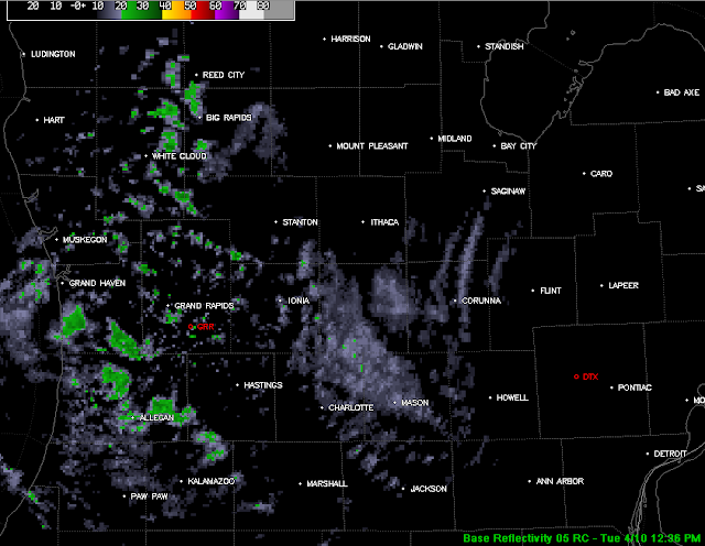
Here's a look at the satellite image and the Doppler radar from Detroit as opposed to Grand Rapids.  You can see the loosely organized showers popping up over eastern Michigan as they depart the area a little better from that side of the state.  Conditions throughout the area are also on the radar image.


You can see pretty clearly where the colder air is advecting into the area, the clouds up in the northern half of Wisconsin are the telltale.


That's all for now, have a wonderful evening!  Blessings.

It's a Monday...


Good Monday Morning!

I hope that all of you had an enjoyable Easter weekend.  Now that we're back to work, it's back to work here in the world of weather (and my day job) as well.

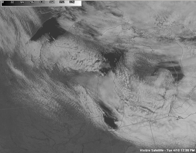
Right now there's a broken layer of clouds throughout the area, especially in the north zone.  Here's the visible satellite picture:


The cold air that we have been forecasting for awhile is still on the way down, let's take a deeper dive and see what's going on:

TEMPERATURES:  We'll stay seasonable today and then then cool it down a bunch tonight.  Tuesday and Wednesday look to be the coolest days of the week, and the thermometers will have their hands full trying to break the 50 mark.  Toward the tail end of the week we should see a nice warm-up, with a shot at 70 in the cards for the weekend.

RAIN/SNOW:  The models have been persistent with cold air coming tonight into tomorrow, and along with that, a chance at rain or snow showers.  Anything that we see will be scattered in nature, and it all should be out of here in time for the morning drive on Tuesday.  The next best chance at rain will be this weekend…just in time to put a damper on the warm-up that the models are suggesting will occur.  Here's the 5-Day Total Precip map from the National Weather Service:


SEVERE WEATHER:  Nothing really of note for Michigan except that some garden-variety thunderstorms COULD fire on the eastern edge of the state today, and that's it.  Now down into Texas and Oklahoma, that's a different ball game altogether.  Severe storms with hail, wind and the occasional tornado are likely through the end of the week.  Here's a look at the breakdown from the Storm Prediction Center, starting with days 1 & 2.  All of these forecasts are effective at 8AM each day:


Here's Day 3:

And here's days 4 through 8.  It all stays in the Great Plains.  Storm chasers are probably licking their chops at this setup.


Here's a look at the current radar, not much to see except the current observations and a few returns that are barely showers way up in the north zone:


Now it's time to look at the forecast:

For today, periods of clouds and sun, windy, high temperature of 53 with west winds 15-25 MPH.

Tonight, clouds increase, then we'll see a chance of scattered rain or snow showers, nighttime lows float within a degree or two of freezing, NW winds 10-20 MPH.  Depending on where you're at in south central Michigan, your precipitation may change once or twice between now and daybreak tomorrow.

Tuesday, any snow or snow showers should change back over to rain by 8AM, then start to clear off by lunchtime.  Partly sunny and cooler, highs near 45.  Winds WNW 10-20 MPH.

Tuesday night, a few clouds about but mainly starry skies, nighttime lows around 30.

Wednesday, mostly sunny, high near 50, winds northerly 7-15 MPH.

Thursday, mostly clear, clouds thicken up toward nightfall, chance of showers late, lows near 36.

Friday, mostly sunny early, then a chance of showers and thunderstorms after lunchtime, high near 56,  spots in the north zone could see temperatures top out in the high 40's. SE winds 5-10 MPH.

Saturday, showers and thunderstorms possible early morning, then partly sunny, but storms rebuild for the evening, high temperatures near 70, WSW winds 7-15 MPH.

Sunday, sunny, pleasant, high near 72, SW winds 10-20 MPH.

That's a look at your weather, update here later this afternoon.  Blessings.

Sunday, April 8, 2012

More Functionality Added!

We've added additional functions to the page.

Thanks to the folks at Weather Underground, in addition to the condition displays down the left column, there is also a weather radio player in the right column now.  Simply scroll down to the city closest to you and hear the weather radio feed from NOAA/NWS.  Also we have an interactive radar on the Radar page as well.  You can zoom, change layers, pan and scroll...it's a great tool!  Play with it.  As always, feedback is welcomed.

Grab A Quick Shower...

Good Evening!

Just taking one final look at the blog and weather picture before calling it a night, and there are showers entering the area from the west.  They are tracking southeast as the whole system moves through.  This is another one of those weak upper waves passing though and bothering the atmosphere just enough to trigger showers.  They are scattered  in nature, and they will be tracking through the southern part of the forecast area first.  Here's a look:


A full update will be available tomorrow morning.  Have a great night!

Excellent Easter!!!

Good Afternoon and Happy Easter!

I hope that all of you have had or will have the chance to relax and enjoy the day with friends or family.
Here in south central Michigan we have plenty of sunshine and temperatures in the high 50’s with a couple of 60’s being reported.  The showers moved through as advertised, though that occurred a little quicker than I expected it to, most places were mainly clear by 9AM, so any morning Easter Egg hunts should have been dry if a bit cool with the stiff northwest breeze.  Here’s a look at the visible satellite image:


Let’s take a deeper dive.

TEMPERATURES:  We’ll see daytime temperatures stay in the 50’s through tomorrow afternoon, as Canadian high pressure continues to edge closer.  After that, things will cool and the thermometer will struggle to reach 50, especially in the north zone.  Temperatures in the south zone counties may hit 50 on Wednesday, we’ll know more tomorrow.

RAIN/SNOW :  We still have a chance of rain showers tonight, and rain or snow showers tomorrow night into late Tuesday.  As the colder high pressure moves in, an upper level wave is riding the cold air leading edge, this could kick off the rain or snow showers.  Anything that does form will be scattered to numerous in nature.  After we get through the Monday/Tuesday stretch, out next chance of rain will come around Friday night into Saturday, as the models are showing a strong upper level disturbance.  We will have a better idea of timing and amount of rain later.  The National Weather Service is expecting us to stay pretty dry through Thursday, here’s their 5-Day Total Precipitation Map:


SEVERE WEATHER:  Nothing here in Michigan for the next several days.  All of the severe potential is staying well to the southwest of us, in the Southern Plains and back into New Mexico.  Here are the Day 1 and Day 2 severe outlooks from the Storm Prediction Center, these are valid at 8AM each day.


Notice that Day 2 features a wider “general” risk area, as well as a small one out east in Ohio, West Virginia, and Pennsylvania.

Once again, I have to include maps that I normally don’t in this section, these are SPC’s day 3 through 8 Severe outlook maps:


With them identifying severe storm potential this far out through Texas, Oklahoma and Arkansas, conditions will need to be monitored closely.  It looks like there is the chance that a significant severe weather event could be stacking up for the south end of Tornado Alley.

Let’s take a look at the local forecast for Jackson County:

For the rest of Easter Sunday, mostly sunny and breezy, an occasional passing cloud, with a high of 58.  WNW winds 15-25 MPH.

Tonight, mostly starry skies some areas could see a passing shower, lows down to 38, westerly winds diminish to 7-15 MPH.

Back to work on Monday with mainly clear skies, increasing clouds as the day progresses, high temperatures near 56.  West winds 10-20 MPH.
Monday night, a chance of rain or snow showers, nighttime lows drop to 31, NW winds 7-15 MPH.

Tuesday, cloudy, a chance of rain or snow showers, high of 43, WNW winds 10-20 MPH.  Rain could change to snow in the evening, as lows will float a couple of degrees either side of freezing.

Wednesday, clearing, then becoming mostly sunny, high near 48, NW winds 8-15 MPH.

Thursday, mostly clear skies but a chance at a passing shower late in the day, high near 55, NNW winds 5-10 MPH.

Friday, mostly sunny, high near 57, SSE winds 10-15 MPH.

There’s a look at your forecast for the area, we’ll have an update later this evening and a complete forecast tomorrow.

Remember to follow me on Twitter: wxMikeD.  You can send weather info or pictures to #scenmiwx on Twitter.

Have a great day!

Showers Enroute...

Good Evening!
 
Taking a look at the radar, a line of showers is slowly moving our way.  Currently they are just entering the state from off of Lake Michigan.  Best guesstimate of an arrival time looks to be somewhere between 2 AM and 5 AM.  The circle around Grand Rapids is ground clutter around the radar site.


They'll move through the area steadily, and they should be gone by the time morning services are over tomorrow.  Heavier rain should stay to the north and out of south central Michigan tonight.  Nothing severe expected in the area.  We'll have a full forecast tomorrow.  Have a great night!