Saturday, August 11, 2012

Late Summer Sun, Then Wet Again...

Good Evening!

Some time to sit down and have a look at the weather data now, and it can be summed up in a couple of words...refreshing, then wet.  Let's look and see what we have under the hood for the next few days here:

TEMPERATURES:  After unseasonably cool temperatures yesterday that I didn't pick up, ultimately leading to a major BUST on my forecast (10 degrees cooler than I predicted), things warm back up some for Sunday and the start of the new work week.  We see temperatures make it back into the 70's and stay in that area until midweek next week, when an 80 might show up.  We're definitely seeing a preview of the end of summer in the regime that we are in.  The ridge/trough setup persists, even though the western ridge does flatten some and allow some warmer air to work it's way in, again, not until next week.  Winds work their way back to westerly as well.

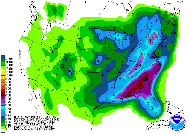
RAIN:  After a brief break in the rainfall for tomorrow, rain chances start to creep back up on Monday, into Tuesday, which is looking pretty wet at this point, then we keep a chance of precipitation in the forecast right through the end of next week.  Here's a look at the five day precipitation forecast from the National Weather Service...
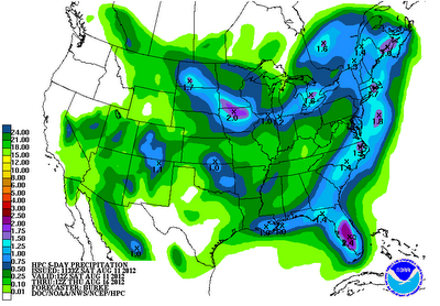
5 Day Precipitation Forecast

As you can see, still a decently wet outlook, with most areas coming up in the one inch ballpark over the next five days.  We'll take the rain even though it arrived later than we hoped that it would have.

SEVERE WEATHER:  Things are looking quiet in this part of the world as far as severe weather.  The Storm Prediction Center has no formal risk outlined for Michigan in the next three days.

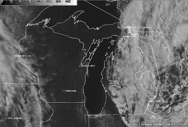
Detroit NEXRAD radar showing just a touch of rain in the area still as that big low FINALLY takes his rain bands east of us, and the visible satellite still shows plenty of cloud cover, but clearing is on the way!
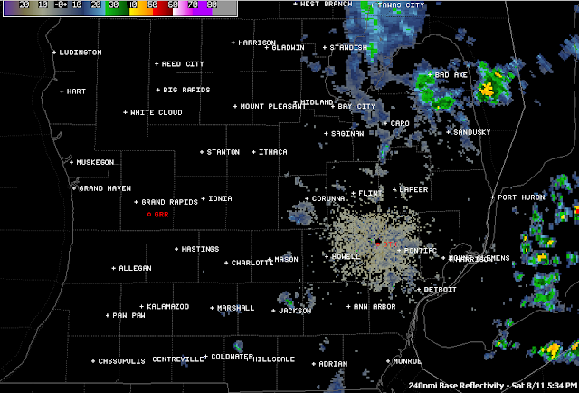
Detroit NEXRAD Radar
Visible Satellite Image
Here's the local forecast for Jackson County...

Tonight, clearing skies, very cool, lows roll all the way back to 52, winds NW 4-8 MPH.

Tomorrow, sunny skies in the morning, some passing afternoon clouds, high 76, winds W 4-9 MPH.

Tomorrow night, mostly starry skies, some scattered clouds, low 58, winds W 3-6 MPH.

Monday, increasing afternoon clouds, a chance of some scattered showers, high 77.

Tuesday, cloudy skies, scattered to numerous showers and perhaps a thunderstorm, cooler, high 71.

Wednesday, partly sunny skies, warmer, high 78.

Thursday, mostly sunny, seasonably warm, chance of an isolated or scattered shower, high 81.

There's a look at your forecast for the next six days, I do hope that you have a great rest of your Saturday!  Blessings.

Clearing On The Way...

Good Morning!

A VERY cool day yesterday throughout South Central Michigan,  Jackson was only three degrees from tying a record for coolest high temperature.  I busted BADLY with the forecast, my high temperature was about 10 degrees warmer than the actual high for the day.  I called for 72, Jackson managed 63.  If you were under-dressed as a result, I apologize.  I was right there with you.

Just a quick forecast for now and the discussion will follow.

For today, cloudy skies, periods of lingering showers, skies slowly start clearing after lunch, high 71, winds NNW 6-12 MPH.

Tonight, continued clearing skies, very cool, lows roll back to 52, NW winds 5-10 MPH.

Sunday, mainly clear skies, warmer, high 76, winds W 7-14 MPH.

That's a quick forecast for the next 36 hours, we'll have the full discussion and forecast for you shortly!

Friday, August 10, 2012

Beneficial Rain...You Bet!!!

Good Evening!

Trying out a couple of new things on the blog, including working in more graphics...let me know what you think.  Here's a quick look at some of the rainfall totals for the last 24 hours in various places in the blog area...

There's more where that came from, the low over Michigan is taking it's own time leaving!

HEAVY RAIN ADVISORY - LIVINGSTON

The National Weather Service Detroit has just issued a Special Weather Statement for Livingston County.  Scattered thunderstorms developing will cause locally heavy downpours.  Roads will quickly develop ponding issues and some low-lying areas could see minor flooding.  Use caution driving home!

A Good Soaker Shares A Taste Of Fall...

Hello Again!

More unseasonably cool and autumn-like weather this morning in The South Central Michigan Weather Zone, with temperatures in the low to mid 50's and drizzle.  If you haven't already, you'll want an umbrella and a jacket or hoodie close by for the next day or so.  We have warmed a couple of degrees but the drizzle has stayed around, and that it will do for a good portion of the day today.  Let's pop the hood and see what we have...

TEMPERATURES:  We'll see temperature running well below normal for the next few days, with the mercury only managing a climb into the mid 70's early next week.  A ridge/trough setup in currently in place over the nation, with scorching summer heat in the southwest under a heat dome, and a deep trough in the eastern half of the country opening the door for cool Canadian air to filter well into the US.  Couple that with copious cloud cover, and you see why the temperatures are showing limited upward mobility the next couple of days.  This pattern is forecast to hold right through the weekend for sure, and I don't expect any real warming until the latter part of next week, when the ridge and trough flatten out some and bring us more west and southwest winds to push some warmer air up this way.  It feels like London today, and you could say it's an extended fall preview for the weekend!  Look at the temperatures around the US...
US Surface Temperatures (12:30PM EDT)
RAIN:  Here's something that I have not been able to say much at all this summer - we'll have moisture in plentiful supply for the next day or so, as a low pressure system sits right on top of us and SLOWLY moves east as he's rotating rain bands over us.  The center of the circulation is sitting right over Jackson, Washtenaw, and Lenawee counties at this hour according to satellite and NEXRAD radar imagery, and the sun will hide from view again today.  Take a look at the five-day precipitation forecast from the National Weather Service:
5 Day Precipitation Forecast

A little bit drier look for the next five days as forecast modeling shows the center of this low pressure system over the border into Ontario.  This area of the state is forecast to pick up anywhere from a half-inch to an additional inch of rain.  That looks like it's in the ballpark, I'm thinking maybe three-quarters of an inch on the high side in the north zone counties, and closer to the half inch south.  After the low takes Mr. Soaker with it, we'll have another shot at rain early Monday if the models have it right.  So far they all agree on the whole getting wet proposition for  the new workweek, timing isn't solid just yet though.

While we are on the subject of rain, just take a look at this NEXRAD radar image from Detroit with all the precipitation on it.  The NWS in Detroit has flood warnings up for Midland, Bay and Saginaw counties as this low continues to spin heavy rain bands over the same area!
Detroit NEXRAD Radar
SEVERE WEATHER:  Pretty quiet in this part of world now, as the severe threat has moved off to the east coast.  We just have the general risk for garden variety thunderstorms in the area for today, then just the northeast part of the blog area gets in on the action for tomorrow at this point.  If anything, flooding will be more of a concern at this point than severe weather.  Rain-cooled air will keep any robust storms from firing, though a buried thunderstorm still isn't out of the question entirely.

Here's a look at the visible satellite image at this hour:
Visible Satellite Image
Still plenty of clouds about, and they aren't going anywhere anytime soon.  Now, let's take a look at the forecast for Jackson and surrounding communities including Concord and Leoni Township...

For today, cloudy skies, continuous drizzle with intermittent showers, high temperature only 71, winds NNE 5-10 MPH.

Tonight, continued cloudy, showers and drizzle very gradually start tapering off late, nighttime lows roll back to 54, winds N 4-8 MPH.

Saturday, still cloudy as the surface low takes his own sweet time moving out, some drizzle or a few lingering showers are still likely through lunchtime, then tapering off, high of 73, winds NW, 5-10 MPH.

Saturday night, some clouds, perhaps a few stars as clearing starts late, cool, nighttime low of 55, winds NW 3-8 MPH.  A touch of drizzle or a stray shower still can't be ruled out early.

Sunday, a mix of clouds and sunshine, a bit warmer with a high of 76.

Monday, mostly cloudy, a chance of scattered showers and a lonely thunderstorm as another disturbance moves in, high 75.

Tuesday, continued mainly cloudy early, with scattered showers lingering, then some clearing after lunchtime, high 76.

Wednesday, periods of clouds and sunshine, an outside chance of a stray shower, a bit warmer, high 78.

There's a look at your forecast for the next six days, I do hope you have a wonderful Friday and a great weekend!  Blessings.

Quick Friday Forecast

Good Morning...full forecast and discussion on the way, but for now, cloudy skies, periods of showers and maybe a thunderstorm, unseasonably cool, high only 71.  Winds NNE 5-10 MPH.

Tonight, showers taper off slowly leaving mainly cloudy skies that should start to clear near daybreak, low 54.  Winds NNW 4-8 MPH.

Full forecast soon!

Thursday, August 9, 2012

Thursday Afternoon Update...

Hello Again!

Just an update of the forecast from this morning for you.  The Storm Prediction Center has redrawn the "slight" risk area for severe weather, and left us out of it this time around.  Here's that map for you...
SPC Day 1 Forecast UPDATED
Additionally, I do need to clarify that in the morning forecast, I said that some areas may briefly get near 80.  I didn't proofread my prose as I usually do, my apologies.  That should have said that some areas may briefly get near 75.  I'm standing by my forecast high of 74 today in Jackson, though the warmest temperature in the area right now is Battle Creek, currently checking in at 70 on the surface observations...
Grand Rapids NEXRAD with observations overlaid on it
As you can see, still plenty of rain on the radar this afternoon, and it will linger right through the evening hours and into early tomorrow.  Just look at this cloud-filled satellite image; gloomy as can be for the rest of the day and well into tonight:
Visible Satellite Image
We'll keep you posted on any flooding issues that may arise from all the rain, but for now, enjoy this good soaker, we haven't had one like this for quite awhile, and we surely need every drop of it!  Have a great rest of your afternoon!

MINOR FLOODING POSSIBLE...

Livingston, Shiawassee, Washtenaw counties, the National Weather Service has a Special Weather Statement out for some locally heavy rain that may cause some minor flooding and ponding of water on roadways today, until rain departs around lunchtime.

USE CAUTION DRIVING THIS MORNING!

Cloudy And Wet, Much Cooler For The Weekend...

Good Morning!

We wake this Thursday to some needed, beneficial rain as showers and thunderstorms move through the area.  Even though this is too late to affect the drought situation as we head into the latter part of summer (I hate saying that), we can still use it to green up things some and perhaps salvage some part of the crops this year.  Time to pop the hood and see what we have going on today...

TEMPERATURES:  The rain-cooled air that we will be under today and into tomorrow will limit temperature climb.  Most places in the blog should briefly get near 80, before an afternoon round of showers and thunderstorms cranks up, as we get some daytime heating and a surface low working in tandem with an upper air disturbance.  Both of those features are tracking right at us.  On the back side of that, the upper air trough deepens and pushes south, opening the door for more of that cool dry air from north of the border to filter in.  Temperatures should stay below 80 until next week!  You might almost consider this a hint of autumn.

RAIN:  Lookie here!  The National Weather Service is predicting over two inches of rain for a good chunk of the Lower Peninsula.  Bring it on!  The medium and long-range forecasting was on target this go round, and I busted a little bit, by saying that the forecast rain totals looked a bit ambitious to me earlier this week.  Of course, the forecast could change again on the next computer run and we go to bone dry, depending on how the modeling stacks up.  At any rate, here's the map from the National Weather Service, showing the amounts for the next five days:
5 Day Precipitation Forecast

The only suggestion I have to add at this point is that I think the eastern part of the Lower Peninsula may trend a bit wetter than this forecast shows.  We have some decent shower activity going northwest of us, up toward Muskegon and Ludington.  We take a bit of a time out later this morning, then we'll see more rain this afternoon and evening, continuing into Friday.

SEVERE WEATHER:  The Storm Prediction Center is showing a "slight" risk for severe storms that covers specifically the south zone of the blog.  Branch, Hillsdale, Lenawee, and the southern halves of Calhoun, Jackson and Washtenaw counties, you're in play for this one.  Here's a look at that graphic:
SPC Day 1 Forecast Map

SPC's forecast suggests damaging wind and perhaps some hail as the main threats from any storms that get to that point.  From my perch here, there's a shot at that happening.  It hinges on what kind of afternoon heating we get, and what shape the atmosphere is in after this morning round of rain moves on out.

The Grand Rapids NEXRAD image shows an echo-filled radar, with plenty of gentle, soaking greens and yellows.
Grand Rapids NEXRAD Radar

Here's a look at the visible satellite image, showing a picture chock full of clouds over this area, and going a ways back west as well...
Visible Satellite Image
Here's the forecast for Jackson and surrounding communities including Vandercook Lake and Rives Junction:

For today, cloudy skies, an outside chance of a peek at sunshine after lunchtime.  Showers and thunderstorms taper off late morning, then re-start in the afternoon, especially south of I-96.  High 74, winds ENE 5-10 MPH.

Tonight, continued cloudy, scattered to numerous showers and thunderstorms expected, some could be strong or even severe, lows roll back to 60, winds ENE 3-8 MPH.

Friday, more overcast skies, scattered to numerous showers and perhaps a couple of roaming thunderstorms persist throughout the morning then slowly taper off in coverage, high 71, winds NE 5-10 MPH.

Friday night, clouds stay around, along with them, a chance of widely scattered or scattered showers, low 59, winds NNE 3-8 MPH.

Saturday, finally some clearing, partly sunny skies, continued unseasonably cool, perhaps an isolated lingering shower as the cold front travels east, high 74, winds NNW 5-10 MPH.

Sunday, a mix of clouds and sunshine, a touch warmer, high 75, winds NW 5-10 MPH.

Back to work on Monday, mostly cloudy skies, a chance of widely scattered or scattered showers, high 74.

Tuesday, clouds stay around, and along with them the chance of a scattered shower or a lonely thunderstorm, high 76.

There's a look at a pretty wet six day forecast for you, I hope you have a great Thursday!
Blessings.

Wednesday, August 8, 2012

As Advertised...Your Forecast Discussion

Good Afternoon!

Sunshine with some clouds around the area right now, and that trend will change over the next several hours, with showers and storms moving into the area and much cooler temperatures as an upper-level trough allows cool air from north of the border to filter in.  Let's pop the hood...

TEMPERATURES:  We'll see temperatures start to cool in the next day or so, and once we get into the rain, we'll see temperatures that won't make it out of the 70's for a couple of days.  Northerly breezes and variably cloudy skies will be on tap for us to start the weekend.  Those sub 80 readings should persist into next week as well.

RAIN:  The National Weather Service is expecting us to pick up well over an inch of rain the next five days, and based on what's coming down the pike, that doesn't look as far-fetched as I figured it would be early in the week.  That being said, summertime rain is always a hit or miss proposition, with some areas picking up barely anything, and other areas getting a good soaking or more.  Here's a look at the map...

5 Day Precipitation Forecast
There you see most of lower Michigan picking up at least an inch according to the forecast.  The bulk of this rain should come in the next two days, as all indications are that we'll see rain for the better part of Thursday into Friday.

SPC Day 2 Forecast
SEVERE WEATHER:  The Storm Prediction Center has us just under the general risk for plain vanilla thunderstorms today, but then for tomorrow, a "slight" risk has been tossed into the mix.  If you look at how the risk area is drawn, anything that does go severe at this point will be primarily a south zone issue according to the forecast maps.  Here's a look at the graphic with SPC's Day 2 forecast:

We'll have to keep an eye on this one, as there's a 30% risk area within that larger "slight" bubble, and that stops just south of the Michigan/Indiana border.  As it stands now, SPC thinks that the best threat is from damaging gusty winds.
Visible Satellite Image
In the satellite image on the right, you can see the storm system spinning off to the west southwest, slowly bringing clouds into the area as the afternoon and evening progresses.
We should start seeing some showers and storms after 11PM tonight, there is already rain in those clouds over Illinois and Wisconsin.

There's your forecast discussion for the day!  I should have an update for your later this evening!  Blessings.

Straight To The Forecast...

Today, periods of clouds and sunshine, becoming mostly cloudy as the day progresses, a chance of some widely scattered showers with perhaps a thunderstorm late this afternoon, high 86, winds becoming N 5-10 MPH.

Tonight, cloudy skies, scattered showers with a few thunderstorms likely, low 63, winds N 4-8 MPH in areas with no storms.

Thursday, mostly cloudy skies, periods of scattered to numerous showers and thunderstorms with a possible break between lunchtime and the drive home from work, high 78, winds NNE 5-10 MPH.

Thursday night, showers and thunderstorms continue, slowly tapering off late, low 60, winds N 5-10 MPH.

We'll have an update and discussion forthcoming this afternoon or evening.  Stay tuned!

Tuesday, August 7, 2012

Sunny, Warm, Summery -- Changes Come Thursday...

Good Afternoon!

Another day of beautiful weather for South Central Michigan today.  Plenty of sunshine and moderate temperatures continue.  Let's take a deeper dive and see what we have...

TEMPERATURES:  We'll see temperatures start to warm just a bit as we head into the middle and back half of the week.  Temperatures should run between 81-87 degrees until then, with increasing humidity until we see the next weather maker move through the area, bringing showers and thunderstorms.  On the other side of that, temperatures don't look to get out of the 70's.

RAIN:  We'll see skies start to darken as we get toward Thursday, with showers and thunderstorms moving in after lunchtime.  An upper wave moves in, touching off some precipitation.  That brings up a little wetter look in the 5 day precipitation forecast from the National Weather Service...


As you can see here, the NWS is thinking that almost two inches will fall in extreme southeast Michigan over the next five days.  While I would love for that to happen, for my money, I think this is a bit aggressive, and amounts more around an inch total should fit the bill.  Still, we'll see what Thursday and Friday look like over the next couple of model runs.

SEVERE WEATHER:  There's not much in the way of severe weather for the next three days here in Michigan.  The Storm Prediction Center has only a slight risk in the forecast on Thursday.
Visible Satellite Image
Sunny skies right now in Jackson, temperatures in the upper 80's, here's the forecast for Jackson County...

For the rest of today, sunny and warm, high 87, winds NW 5-10 MPH.

Tonight, mostly starry skies, pleasant, lows near 62, winds SW 3-8 MPH.

Wednesday, continued sunny skies and warm, high 86, winds SW 5-10 MPH.

Wednesday night, clouds start to increase, a slight chance of a scattered shower, lows 64.  Winds SW 5-10 MPH.

Thursday, mainly cloudy skies, perhaps a peek or two of sunshine, chance of scattered showers and thunderstorms, high 86.

We'll have a complete six day outlook for you this evening.  Have a great rest of your day!  Blessings.

Monday, August 6, 2012

Great Mid-Summer Weather!!!

Good Afternoon!

A gorgeous day is shaping up here in the South Central Michigan Weather Zone for you today.  Abundant sunshine and comfortable temperatures, it doesn't get a whole better than this!  I want to show you a graphic right out of the blocks today, this is a value called precipitable water...
Precipitable Water
Precipitable Water (PW) is another measure of moisture in the atmosphere, specifically water vapor.  If we were to get a ridiculously long rain gauge (a couple of miles long), stand it up, bottle up some air in it and then condense out all the water so it's liquid and not gas, you'd have some water in the bottom of the gauge; the higher the PW value, the more moisture there is to make clouds and perhaps precipitate on you.  Meteorologists and forecasters use this as one of many tools to help them determine a given area's shot at cloud cover and precipitation.

Now that the explanation is over, you can see the low PW values of an inch or less here, that with the northwesterly flow means blue skies, dry, comfy, non-humid air, but unfortunately, no rain.  The dewpoints are also very low today as well.  IN fact, let's pop the hood and see what else is going on here...

TEMPERATURES:  We'll see temperatures stay in this mild, pleasant regime for the next few days.  The heat is bottled up in the southwest, and a deep trough has settled in over the eastern part of the US.  Daytime highs around the area should stay in the 79-84 range until Wednesday, then after that we start to see things warm a bit, in advance of the next weather maker.

RAIN: The National Weather Service is forecasting a half-inch for this area and we are bracketed by areas closer to an inch of rain.  The half-inch prediction looks right to me, we'll have to see what the modeling shows us as we get a little closer to Thursday, as that is the next solid chance for rain in this area.  Here's a look at that five day precipitation forecast from the NWS.
5 Day Precipitation Forecast
SEVERE WEATHER:  Not is this part of the world.  The Storm Prediction Center is showing the severe weather anywhere else but here for today.  Tomorrow we so see a "general" risk for garden variety thunderstorms, but beyond that, not much in the way of anything significant.  Day three, a 5% chance is showing up in the Upper Peninsula.  Not much beyond that.

Just an isolated patch of high clouds well to the northwest of us, other than that, clear as can be in Michigan...
Visible Satellite Image
Here's a look at the forecast for Jackson and surrounding areas including Hanover-Horton and Springport:

For today, sunny skies, gentle breezes, seasonably pleasant, high of 82, winds SW 5-10 MPH.

Tonight, starry skies, perhaps a lone cloud or two floats by late, lows down to 58, winds NW 3-7 MPH.

Tuesday, continued sunny and a bit warmer, high 84, winds WSW 5-10 MPH.

Tuesday night, another mainly clear night, a few clouds form late, lows roll back to 61, winds WSW 3-8 MPH.

Wednesday, plenty of sunshine with a few passing clouds later in the day, high 83, winds NW 5-10 MPH.

Thursday, a mix of clouds and sunshine, a chance of scattered showers and perhaps a thunderstorm in the afternoon and evening, high 84.

Friday, partly cloudy skies early, a chance of scattered showers in the morning and early afternoon cannot be ruled out, high 80.

Saturday, mostly sunny, breezy, high 81.

Sunday, another sunny day with a few clouds in the afternoon, a touch cooler, high 80.

There's a look at your forecast for the next six days, I do hope that you have a great day!
Blessings.

Sunday, August 5, 2012

Clearing, Cooler, Less Humid

Good Morning!


The severe threat didn't develop here as advertised last night, the storms that looked so impressive from northern Illinois through the Chicago area and into northern Indiana went flat as they tracked this way, just leaving us with some scattered shower activity and a couple of isolated thunderstorms.  These same storms knocked down trees and produced a couple of tornado warnings as a couple of brief spin-ups were detected over by the lake shore and then in northern Indiana as well.  This morning, skies are cloudy but clearing, let's pop the hood and see what we have:


TEMPERATURES:  With the passing of the cold front that brought the rain to south central Michigan, we'll see temperatures climb into the low 80's later today, with clearing skies limiting the amount of heating that we actually see.  That trend looks to continue for the next several days throughout the area, with primarily sunny skies as well.  A ridge/trough pattern will bring a bit cooler northwesterly flow in for at least a couple of days, then winds coming more westerly bring us slightly warmer temperatures, as the ridge with the truly brutal heat stays off to the southwest.  For today, we'll still have a good part of the day to get through today before the drier, less humid air winds it's way in.


RAIN:  We picked up a smidgen of badly needed rain last night and into this morning, but the bad news is, that's about all until late this week.  Thursday looks to be the next real chance at any rain beyond the occasional afternoon pop-up shower or thunderstorm that is typical this time of the year in the Midwest.  Here's a look at the 5 day precipitation outlook from the National Weather Service:
5 Day Precipitation Forecast
NWS says we're looking at between half to three-quarters of an inch of rain for the next five days, I personally am thinking a half-inch would be on the high side.  This looks a touch overdone, unless Thursday sets up to be a real soaking rain type day, and right now, I don't see that.  This could change as the next day or two evolves though - we'll have to see.


SEVERE WEATHER:  The severe weather threat has shifted out of here and to the east, with us just being in the "general" risk area for garden variety storms today, and then nothing for Monday and Tuesday.  There's still plenty of moisture in the air at this hour, but with all the clouds, it doesn't look like it will get hot enough to help create the really unstable air that big storms like to work on.


Grand Rapids NEXRAD is quiet, here's a look at the visible satellite image, showing clouds slowly exiting the blog area to the west, then just some scattered clouds behind that:
Visible Satellite Image
And here's the forecast for Jackson and surrounding communities including Parma and Rives Junction:


For today, cloudy skies become clear late this afternoon, cooler and less humid, seasonably pleasant.  High 82, winds NW 6-12 MPH.


Tonight, mainly starry skies with perhaps a passing cloud, unseasonably cool nighttime lows roll back to 52, winds NW 5-10 MPH.


Monday, continued sunny and seasonably mild, high of 81, winds NW turning WSW 5-10 MPH.


Monday night, more clear skies and cool temperatures, nighttime lows roll back to 54, winds SW 3-8 MPH.


Tuesday, mostly sunny skies with a few passing clouds, warmer, high 84, winds SW 5-10 MPH.


Wednesday,  periods of clouds and sunshine, mild, high 81.


Thursday, mainly cloudy skies with a few peeks at sunshine, a widely scattered shower is possible, high 83.


Friday, continued cloudy, still the chance of a scattered shower, high 80.


There's a look at your forecast for the next six days, I do hope you have a wonderful day!  Blessings.