While all of the weather enthusiasts and severe weather fans have their attention directed out to the evolving severe weather event in the Plains, we still have a state right here that needs some attention too. Plus a couple of developments have occurred since the AM forecast.
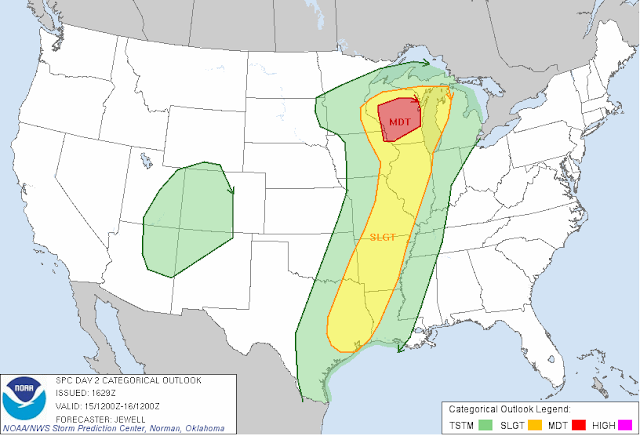
The big change is a revision of the Day 2 forecast map by the Storm Prediction Center. Take a look at this updated map:
Notice the new "moderate" risk covering pretty much all of Wisconsin, and the "slight" risk that has crept across Lake Michigan and covers the south half of the upper peninsula and a sliver of northwestern lower Michigan. That "slight" risk goes all the way down into the ArkLaTex. That wasn't in the SPC forecast this morning.
That moderate risk is out in front of the deep surface low that is making all the ruckus in the Plains today. Computer models are all liking a track northwest right up through Wisconsin, and upper Michigan, including the northern part of the Lower Peninsula tomorrow into Monday. Models are also showing good upper level support for showers and thunderstorms in the area. We'll know this evening how much this impacts the forecast for next week.
The bulk of the rain is staying south of Michigan for now, and that looks to hold for at least a few more hours. Do not be surprised to see showers and storms re-develop tonight into tomorrow.
More to come later!

No comments:
Post a Comment