Good Morning!
We'll have a complete discussion and planner for you a little later. With respect to the snow and possible storms next week, I can say that we are seeing more data line up into something we can work with.
I'm seeing model agreement on a solution that brings us an event next Monday/Tuesday, with a bigger, meaner one for the end of the week. The Global Forecast System (GFS) computer model is finally joining the party that the Euro and GEM have been at the last several model runs. I'm predicting we'll see two low pressure systems phase up over or very close to us, and we'll be looking at some decent precipitation early next week. The main event should come next Friday, as it looks like we'll take a direct hit from a strong low coming out of the Plains, adding some more snow to the picture. We'll firm up details on that as the time draws nearer - still plenty of time for significant changes. Have a look at these maps:
Here's you see the respective model solutions for next Tuesday morning. If these verify, expect a system that will bring us couple of inches of new snow, maybe a bit of rain and perhaps more. We will have to see if it holds or shows major changes in future outlooks.
We'll have the planner and forecast up for you later. Have a great day!
Thursday, February 14, 2013
Wednesday, February 13, 2013
Snow Showers And Such...
Good Evening!
We had a fairly nice day around the area, especially south, with temperatures up near or even past the 40 degree mark. All of that starts to change as we work through the day tomorrow. Let's take a deeper dive and see what we have:
SUMMARY: One more day of milder than normal temperatures for us tomorrow as the day gets rolling and we get to a high around 41 in the south zone, and 38 in the north zone. I think we will see a sprinkling of low 40's in a few places north, even if only briefly. Clouds roll in and wind picks up ahead of a low that should track across the the upper part of the state. After we get that system out of here, the fridge door opens from Canada and we get some of that Canadian air in here to drop temperatures back to sub-freezing levels for awhile. Average temperature in this part of the world is around 35 degrees, and we stay below that through next week. We begin to warm back up early next week, but there's something in the works to potentially coincide with that warm up...
PRECIPITATION: Not a whole lot to talk about right now, but that will change, especially north. As low pressure moves in tonight, we see a chance at some light snow or snow showers, especially in the north zone of the blog. That precipitation could be here as early as morning drive, but for my money, I think we see that after work and school are underway, in a window from perhaps 9 AM to 2 PM tomorrow. This isn't a washout or heavy snow event, but just bear it in mind. I would also keep an eye out for some freezing rain right now. That leaves by tomorrow night, and then we stay fairly quiet until next week. Let's take a look at the National Weather Service forecast for the next five days:
We note a couple of six-tenths of an inch of liquid bullseyes along the lake shore, so we'll need to see how strong our northwest winds are to determine if that suggested lake-effect snow will come a ways inland. That is connected with a system that is forecast to move in on Monday evening into Tuesday. I'll have to keep an eye on this system, as a couple of possibilities are on the table. One is two low pressure centers, one just into Canada, another in the ArkLaTex, and they kind of do their own thing, we get "sandwiched" a bit and pick up some precipitation. The other scenario is the same two lows in roughly the same places, but the southerly low turns a bit more northeast, then they phase up very near us, creating a much more intense storm.
Here's a look at the radar composite, and that shows you what's headed this way for tomorrow...
Now let's have a look at the forecast for Jackson and surrounding areas including Concord and Grass Lake:
Tonight, increasing clouds, perhaps a stray flurry late, low 27, winds SW 5-15 MPH.
Thursday, cloudy skies, snow showers or a wintry mix developing, high 41, winds SW 7-13 MPH.
Thursday night, cloudy skies, precipitation tapers off, colder, lows near 22, winds turning NW 5-10 MPH.
Friday, overcast and gray, colder, high 29, wind NW 6-12 MPH.
Friday night, clouds stay with us, colder still, lows, near 14, wind chills in the single digits are possible with winds NW 5-10 MPH.
Saturday, mostly cloudy, chilly, high 24.
Sunday, a mix of clouds and sunshine, continued chilly with a high of 26.
Monday, a few peeks of sunshine, then clouds increasing, milder high 36.
Tuesday, snowshowers, cloudy, high 36.
Wednesday, some clearing skies, colder, high 29.
There's a look at your six day forecast, I hope you have a great night!
We had a fairly nice day around the area, especially south, with temperatures up near or even past the 40 degree mark. All of that starts to change as we work through the day tomorrow. Let's take a deeper dive and see what we have:
SUMMARY: One more day of milder than normal temperatures for us tomorrow as the day gets rolling and we get to a high around 41 in the south zone, and 38 in the north zone. I think we will see a sprinkling of low 40's in a few places north, even if only briefly. Clouds roll in and wind picks up ahead of a low that should track across the the upper part of the state. After we get that system out of here, the fridge door opens from Canada and we get some of that Canadian air in here to drop temperatures back to sub-freezing levels for awhile. Average temperature in this part of the world is around 35 degrees, and we stay below that through next week. We begin to warm back up early next week, but there's something in the works to potentially coincide with that warm up...
PRECIPITATION: Not a whole lot to talk about right now, but that will change, especially north. As low pressure moves in tonight, we see a chance at some light snow or snow showers, especially in the north zone of the blog. That precipitation could be here as early as morning drive, but for my money, I think we see that after work and school are underway, in a window from perhaps 9 AM to 2 PM tomorrow. This isn't a washout or heavy snow event, but just bear it in mind. I would also keep an eye out for some freezing rain right now. That leaves by tomorrow night, and then we stay fairly quiet until next week. Let's take a look at the National Weather Service forecast for the next five days:
![]() |
| National Weather Service 5 Day Precipitation Forecast |
Here's a look at the radar composite, and that shows you what's headed this way for tomorrow...
Now let's have a look at the forecast for Jackson and surrounding areas including Concord and Grass Lake:
Tonight, increasing clouds, perhaps a stray flurry late, low 27, winds SW 5-15 MPH.
Thursday, cloudy skies, snow showers or a wintry mix developing, high 41, winds SW 7-13 MPH.
Thursday night, cloudy skies, precipitation tapers off, colder, lows near 22, winds turning NW 5-10 MPH.
Friday, overcast and gray, colder, high 29, wind NW 6-12 MPH.
Friday night, clouds stay with us, colder still, lows, near 14, wind chills in the single digits are possible with winds NW 5-10 MPH.
Saturday, mostly cloudy, chilly, high 24.
Sunday, a mix of clouds and sunshine, continued chilly with a high of 26.
Monday, a few peeks of sunshine, then clouds increasing, milder high 36.
Tuesday, snowshowers, cloudy, high 36.
Wednesday, some clearing skies, colder, high 29.
There's a look at your six day forecast, I hope you have a great night!
Quick Nighttime Look...
Good Evening!
Here's a look at the forecast for tonight in the big three of the blog. I am working on detailed discussion as we speak:
More to come soon...
Tuesday, February 12, 2013
Just A Touch Of Variety...
Good Morning!
Well, time to own up to a busted forecast. Where did the snow come from? Simple. Air aloft at or below freezing, strong winds mixing that all the way down to the surface, and voila! I had precipitation in the forecast, but I wasn't thinking it would be the frozen variety. Nuts. Next?
SUMMARY: Cloudy skies right now, they stay that way for the most part today, I don't see any snow falling today that amounts to anything, but we can't rule out a stray flurry or two. We'll keep the temperatures above average, hovering right around the 40 degree mark. After Thursday, things cool down again as we get some chilly Canadian air in here; readings do not even break 30 for the weekend. Next week we get back into the mid to upper 30's part of the thermometer, and stay around there for a bit, but then changes may be in the offing...
PRECIPITATION: Not much going on in the immediate future, maybe some stray flurries or a lonely shower tomorrow. Thursday a more substantial chance at some rain as a low walks across the northwest part of Michigan up by Cadillac and Traverse City. Some light rain or snow shower activity is a safe bet, I don't see it amounting to a whole lot though. I'm thinking more so rain since we'll be on the "warm" side of that system, but I'll need to see some air temperature plots to solidify that. The National Weather Service 5 day forecast backs that up...
LOOKING AHEAD: Let me preface this by saying that this part of the forecast I don't do very often just because of the uncertainty of it all this far out. Have a look at this ONE model, the GFS, Tuesday afternoon at 1 PM.
That being said, a couple of the computer forecast models are toying with a storm for us next week. I see two takers on that notion, and a third is sniffing around the idea. Remember, this is just an idea, and I am NOT predicting anything yet. We will see.
Let's bring it closer to home and have a look at the forecast for Jackson and surrounding areas including Spring Arbor and Michigan Center...
This afternoon, cloudy skies, seasonable, perhaps a few flurries or a light shower, high 34, wind SW 6-12 MPH.
Tonight, mainly cloudy skies, perhaps a bit of clearing later, low 21. Wind SW 3-7 MPH.
Wednesday, a mix of clouds and sunshine, milder, high 38. Wind SW 5-10 MPH.
Wednesday night, some stars, clouds thicken as the night progresses, lows near 26, wind SW 5-10 MPH.
Thursday, cloudy skies, some scattered showers or perhaps snow showers high 40.
Friday, cloudy and colder, high 31.
Saturday, cloudy skies, even colder, light snow possible, high only 26.
Sunday, clouds thin as the day progresses, high 27.
Monday, partly cloudy skies, not as cold, high 37.
There's a look at your forecast for the next six days, I do hope that you have a great day! Blessings.
Well, time to own up to a busted forecast. Where did the snow come from? Simple. Air aloft at or below freezing, strong winds mixing that all the way down to the surface, and voila! I had precipitation in the forecast, but I wasn't thinking it would be the frozen variety. Nuts. Next?
SUMMARY: Cloudy skies right now, they stay that way for the most part today, I don't see any snow falling today that amounts to anything, but we can't rule out a stray flurry or two. We'll keep the temperatures above average, hovering right around the 40 degree mark. After Thursday, things cool down again as we get some chilly Canadian air in here; readings do not even break 30 for the weekend. Next week we get back into the mid to upper 30's part of the thermometer, and stay around there for a bit, but then changes may be in the offing...
PRECIPITATION: Not much going on in the immediate future, maybe some stray flurries or a lonely shower tomorrow. Thursday a more substantial chance at some rain as a low walks across the northwest part of Michigan up by Cadillac and Traverse City. Some light rain or snow shower activity is a safe bet, I don't see it amounting to a whole lot though. I'm thinking more so rain since we'll be on the "warm" side of that system, but I'll need to see some air temperature plots to solidify that. The National Weather Service 5 day forecast backs that up...
![]() |
| 5 Day Precipitation Forecast |
![]() |
| Global Forecast System Forecast Map Valid Tuesday 1 PM |
Let's bring it closer to home and have a look at the forecast for Jackson and surrounding areas including Spring Arbor and Michigan Center...
This afternoon, cloudy skies, seasonable, perhaps a few flurries or a light shower, high 34, wind SW 6-12 MPH.
Tonight, mainly cloudy skies, perhaps a bit of clearing later, low 21. Wind SW 3-7 MPH.
Wednesday, a mix of clouds and sunshine, milder, high 38. Wind SW 5-10 MPH.
Wednesday night, some stars, clouds thicken as the night progresses, lows near 26, wind SW 5-10 MPH.
Thursday, cloudy skies, some scattered showers or perhaps snow showers high 40.
Friday, cloudy and colder, high 31.
Saturday, cloudy skies, even colder, light snow possible, high only 26.
Sunday, clouds thin as the day progresses, high 27.
Monday, partly cloudy skies, not as cold, high 37.
There's a look at your forecast for the next six days, I do hope that you have a great day! Blessings.
Monday, February 11, 2013
Quick Look For Monday...
Good Morning!
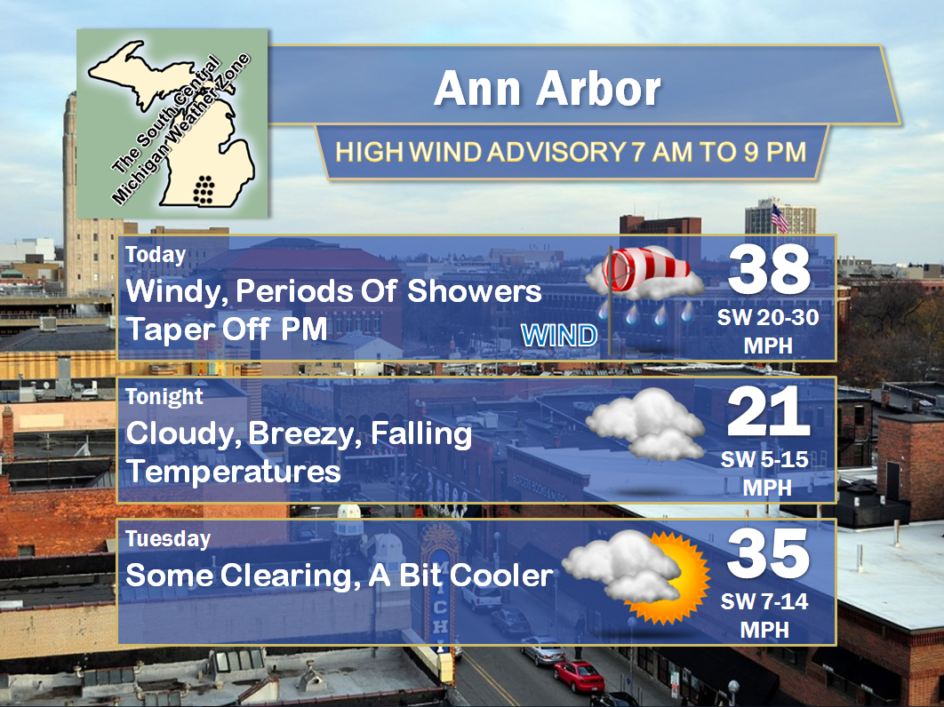
Back to work, gray and windy! Here's the short term forecast for Lansing, Jackson, and Ann Arbor:
Please let me know what you think about the graphics refresh that I did. Have a great day!
Back to work, gray and windy! Here's the short term forecast for Lansing, Jackson, and Ann Arbor:
And here's a look at the Grand Rapids NEXRAD, showing some light rain showers and a bit of snow mixed in with that up near White Cloud and Big Rapids.
Please let me know what you think about the graphics refresh that I did. Have a great day!
Subscribe to:
Posts (Atom)