Good Morning!
We'll have a complete discussion and planner for you a little later. With respect to the snow and possible storms next week, I can say that we are seeing more data line up into something we can work with.
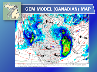
I'm seeing model agreement on a solution that brings us an event next Monday/Tuesday, with a bigger, meaner one for the end of the week. The Global Forecast System (GFS) computer model is finally joining the party that the Euro and GEM have been at the last several model runs. I'm predicting we'll see two low pressure systems phase up over or very close to us, and we'll be looking at some decent precipitation early next week. The main event should come next Friday, as it looks like we'll take a direct hit from a strong low coming out of the Plains, adding some more snow to the picture. We'll firm up details on that as the time draws nearer - still plenty of time for significant changes. Have a look at these maps:
Here's you see the respective model solutions for next Tuesday morning. If these verify, expect a system that will bring us couple of inches of new snow, maybe a bit of rain and perhaps more. We will have to see if it holds or shows major changes in future outlooks.
We'll have the planner and forecast up for you later. Have a great day!


No comments:
Post a Comment