Thursday, March 27, 2014

Spring Rolling In - After More Freezing Stuff...

Good Morning!

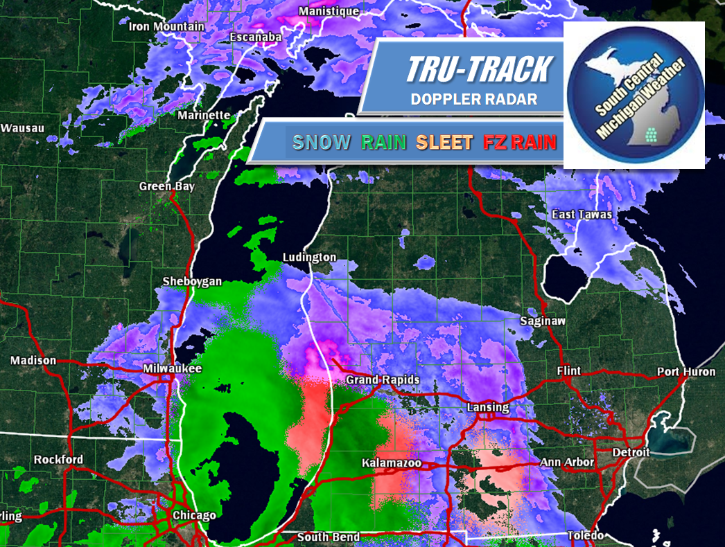
A messy start to the day as we wind down the morning commute.  If you're leaving to go somewhere in the next hour or two, be aware you may hit a slick spot or two from freezing rain or sleet.  This should transition to all rain later as we warm up.  Have a look at the current Tru-Track Doppler picture:

A mixed bag of precipitation all over the southwest and south central part of Lower Michigan today, snow in the U.P.
Forecast looks good after we get out of this rain/freezing stuff!


Have a wonderful day!  Blessings.

Wednesday, March 26, 2014

March Looks To Leave In Lamb-Like Fashion...

Good Morning!

Clear skies as we head into lunchtime on this hump day.  Snow has moved out of the area, with some clouds here and there to break up the blue sky.  Let's take a look and see what we have going on...

A GOOD DOSE OF SUNSHINE AND COLD:  That's what we have for the next day or so here in the area, but you can rest assured that we will have warming temperatures paying us a visit here as soon as tomorrow evening.  Even tonight shouldn't be quite as cold as the last couple of nights...

This surface temperature map shows the ridge/trough that we have seen all winter long.  If you look out to the southwest of us, there's a couple of small ridges with some 40's in them.  That's the air I expect to work into the area over the next two days, pushing readings into the 40's.

WARMING FOR NEXT WEEK:  If everything plays out as advertised, we'll finally get reasonably close to seasonal temperatures next week.  Average high in the area is around 51 degrees, and the computer forecast models seem to be happy with a high temperature spread between 43 and 56 over the next week.  We'll have to tweak and adjust those numbers as we go along, but it will be nice to not have to talk about daytime readings near or below freezing for the next several days!

SOME SHOWERS AND STORMS?:  For the first time this year I have to talk about some showers and storms in the forecast.  I'm thinking mostly showers as the upper air setup isn't all that favorable for thunder, but you never know.  It is spring in the Midwest.  There's not a lot of energy available for storms on Thursday, so I'm going to mention scattered showers.  There will be the chance of a lonely storm though, so be aware.

After the showers and such Thursday night into Friday, once we get those out of the way, we go to variably cloudy with some chances of showers or even some flurries at night, as temperatures will drop close enough to freezing at that point to support flakes.

Here's the forecast for Jackson and surrounding areas including Summit Township and Rives Junction:


And here's a look at the extended forecast - so far all signs indicate we get warmer and more or less stay there for the time being!


I hope you have a wonderful day!  Blessings.
Tuesday, March 25, 2014

Warming On The Way - But Old Man Winter Hasn't Left Yet!

Good Morning!

Not a whole lot of change to report on regarding previous posts for the weather this week.  Instead of a detailed deep dive, we'll just run down the highlights and then set you up with a forecast:


  • The snow from last night and today so far isn't verifying as intensely as was forecast.  There's just a few pockets of light snowfall here and there, with flurries elsewhere.  Apparently the model solutions were a bit fast, and possibly a bit aggressive regarding snowfall totals.  The air columns still are set up right for an inch or two of snow, but we'll just have to wait it out and see what comes as the day progresses.
  • We switch to a clear and cold motif after this disturbance works through.  Temperatures will be more seasonable for the dead of winter than almost a week into spring.  The bomb off the New England coast will be the dominant map feature for the next couple of days, with Hurricane Force Wind Warnings up for the Atlantic waters off New England.
  • Thursday, we see some warming and our next system rolling in.  Temperatures climb into the 40's, and that air setup opens the door for all modes of precipitation initially, switching to showers and maybe a thunderstorm from late Thursday on into the weekend.  Readings will finally be seasonable, at least for awhile.
  • Early next week, we switch back to colder weather - this doesn't look too wintry, but you won't want to put away the winter hats and such just yet.  You should be able to thin down a layer during the day though, and even at night, readings shouldn't get into the lower 20's or colder as they have this week.
Here's the forecast for Jackson and vicinity

Today - mainly cloudy, a few peeks of sunshine, snow anywhere from a dusting to an inch possible throughout the area, high 27, wind NW 5-10 MPH will keep wind chills down in the teens or lower 20's.

Tonight - clearing skies and very cold, temperature down to 6.  Winds WNW 3-6 MPH will push wind chill values down to near zero.

Hump Day - Mainly sunny with some passing clouds, a touch warmer, high 31.  Wind turning S 5-10 MPH, wind chills will stay in the low to mid 20's accordingly.

Tomorrow Night - clouds increase, not as cold, lows roll back to 24, wind S 5-10 MPH.

Thursday - mainly cloudy, mixed precipitation will give way to scattered showers and perhaps even a lonely thunderstorm, warmer, high 41.

Friday - Scattered showers in the morning give way to clouds in the afternoon, a couple of peeks of sun should be seen after lunchtime, high 44.

That should hold you until I can get a more detailed and graphics aided forecast up for you.  Have a great day!  Blessings.

Sunday, March 23, 2014

A Peek At The Week...

Good Evening...

With some time to look at some data, it became clear that some tweaks were in order.  Here's what we're looking at:


That should about fill the bill, have a good night!

Maybe A Bit Of Spring Mid Week...

Good Morning!

The picture has become much clearer regarding our chances of rain and snow over the coming week.  We do see a brief bit of warming for the end of the week, but we also see winter-like conditions hang on for awhile.  Let's have a closer look and see what's running under the hood:

WINTER TEMPERATURES LINGER:  No warming on the horizon yet, with temperatures staying around the freezing mark for daytime highs, for the next few days.  No real signs of Spring until we get into the latter half of the week, when we break 40 and start climbing to more seasonable readings.  Seasonal average this time of year is right around 50 degrees.

SOME SNOW FOR MID WEEK:  We'll see a disturbance work into the area Tuesday that will bring us some light snow.  I don't think we get a lot out of it, no more than around an inch, but old man winter is not going quietly.  Enough said.  Temperatures will remain winter-like, but we'll start seeing some changes Wednesday.

WARMING FOR THE END OF THE WEEK:  As we get into Thursday and Friday, we see warmer conditions, with readings trending up toward 50, and some showers possible late Thursday and Friday.  I'm not seeing any thunderstorm activity with this system - not enough instability around for convection.  These look like just plain vanilla showers, and a snowflake here and there mixed in with them is still a possibility.  After that system comes through the area, we cool back into the mid-upper 30's or so.

Here's the forecast for Jackson and surrounding areas including Parma and Michigan Center: