Tuesday, February 19, 2013

Cold & Snowy -- Until The Weekend...

Good Afternoon!

The rain we had this morning has completed the changeover to snow, it is quite blustery, and it is COLD.  Wind chills are hovering in the teens, and some places are even in single digits owing to the westerly winds blowing at 20-30 MPH or better.  Here's a look at the midwest:


Yes, that cold front is moving, now let's take a look and see what's running under the hood the next few days...

SUMMARY:  Cold and snowy through tonight, we start to quiet down some tomorrow, then we start to warm for the weekend with temperatures climbing into the 40's by Monday.  Another round of precipitation in time for the weekend though.  Looks like some freezing rain may be possible as another system tracks at us from the southwest.  Temperatures are close enough to freezing that we have to mention some freezing rain or maybe snow showers briefly.

PRECIPITATION:  A series of lows and upper disturbances work through the area Friday then againon Monday.  The good news is that there's nothing overly dramatic expected, just your garden variety winter weather, maybe some lake effect snow thrown in just to keep things interesting.  Here's a look at what the National Weather Service (NWS) thinks that we will see regarding precipitation for the next five days:

5 Day Precipitation Forecast valid thru Sunday 7 PM
Now you see that the NWS forecast has a fairly uniform quarter to half-inch in the forecast, I think we need to change that slightly and put in a half to three-quarters of an inch close by the lake because of the lake-effect snow. Here's a look at the forecast for Jackson and surrounding areas:


Today, Winter Weather Advisory through 7 PM.  Cloudy, cold, blowing and drifting snow possible, total accumulations as much as 3" in some spots, high 25, wind NW 15-25 MPH with gusts to 40 possible.

Tonight, snow starts to taper off, light snow may persist, little additional accumulation expected, colder, low 12, wind NW 6-12 MPH, wind chills expected to fall into the single digits.

Wednesday, cloudy to start, some clearing later, seasonably cold, high 25.  Wind NW 10-20 MPH will keep wind chills down around 10 degrees.

Wednesday night, some partial clearing, cold, lows near 15, wind working from NW to ESE 6-12 MPH.

Thursday, periods of clouds and sunshine, high 26.

Friday, mainly cloudy, a wintry mix or some snow can't be ruled out, any falling snow should see accumulations less than 2".  High 35.

Saturday, still mostly cloudy, a slight chance of snow or freezing rain, high 34.

Sunday, mainly cloudy with a peek or two of sun, some spots may see a brief snow shower, a touch milder, high 37.

Monday, clouds linger, scattered showers possible, high 41.

There's a look at your six day forecast, I do hope that you have a great day!  Blessings.

A Slew Of Weather Advisories...

Good Morning!

Plenty of changes in progress, and weather advisories to go along with them, so let's run them down for you:

WINTER WEATHER ADVISORY:  Jackson, Calhoun, Eaton, Ingham, Clinton - Thru 7 PM tonight.  If you're in these counties, you can expect:
  • Slick travel as rapidly falling temperatures lead to icy roads, especially those that are untreated.
  • Precipitation currently falling as a wintry mix changing to all snow later this morning, with 1-4' of new snow accumulating by later tonight.
  • West winds gusting to 35 MPH creating very low wind chills.
  • Blowing/drifting snow creating rapid visibility changes & dangerous travel conditions.
WIND ADVISORY:  Branch, Hillsdale, Lenawee, Washtenaw, Livingston, Shiawassee - Thru 7 PM tonight.  If you're in these counties, you can expect:
  • Sustained winds swinging from southwest to west-northwest and increasing to 30+ MPH.
  • Wind gusts as high as 45 MPH.
  • Tricky driving conditions, especially if driving high-profile vehicles and/or traveling on north/south roads.
  • Lighter weight unsecured objects could be blown around.
As a matter of full disclosure, Branch and Hillsdale counties are serviced by the National Weather Service (NWS) Northern Indiana office.  The product they officially issued was a Special Weather Statement, however for ease of communication, after reviewing the text of it I lumped it in with the Wind Advisory that NWS Detroit issued.

Here's a look at the revised snow forecast for Michigan, and a look at the current Grand Rapids NEXRAD:


Please be careful traveling today.  If you're in Southwest Michigan, Ben Kouchnerkavich and Southwest Michigan Weather will have details.  South Central Michigan, you're in the right place for updated weather information.  I may be helping Ben a bit as he is having some technical difficulties that should soon be resolved.

Have a great day!

Monday, February 18, 2013

WINTER WEATHER ADVISORY

The National Weather Service Grand Rapids has issued a Winter Weather Advisory for Clinton, Eaton, Ingham, Calhoun & Jackson counties starting at 7 AM tomorrow and running thru 7 PM.  If you're in these counties you may see:

  • Snow up to 3"
  • Blowing & Drifting Snow
  • Gusty Winds up to 40 MPH
  • Reduced Visibility
  • Slick Travel Conditions
Allow extra time tomorrow to get in to work or school!

Mild & Damp Becomes Cold & Snowy...

Good Morning!

Clouds and sun mixed in the area right now, and some changes on the way, let's take a deeper dive and see what we have running under the hood:

TEMPERATURE SWINGS:  Temperatures will reach into the upper 30's low 40's across the area, but they don't stay there very long.  Southwest winds under a small upper ridge moderate things just for today, in front of our next weather maker, a surface low that should slide off to the northwest this evening and during the overnight hours.  Have a look at the current temperatures not just here, but around the nation:

US Surface Temperatures
After that, we roll back into the mid or upper 20's until the weekend on some strong northwest winds, then the 30's return to the area with more zonal west to east flow.  The new week could kick off with a few 40's then we get into an unsettled winter pattern again.

MIXED BAG OF PRECIPITATION:  Some changes in the air for the next 24-48 hours regarding our fairly dry weather.  We notice a surface low tracking east-northeast then turning more north, and as that low passes winds swing from southwest to northwest and fire up the lake effect snow machine.  Be glad this isn't the Dakotas or Minnesota, where a Blizzard Warning is in effect!  We do have a Winter Weather Advisory has been issued for Calhoun, Eaton, Ingham, Clinton and Jackson counties starting 7 AM tomorrow morning and running through 7 PM tomorrow night.  This is for the precipitation I just mentioned.  We stay warm, and expect primarily rain until the low passes us.  Winds then shift and increase, changing rain to a wintry mix and accumulating snow, creating blowing and drifting issues.  Here's the latest snow forecast map from the National Weather Service...

National Weather Service Snow Forecast Thru 7 PM Tuesday
After that leaves, other than some lingering lake-effect from the NW winds off Lake Michigan, we quiet down until Friday, when another disturbance tracks at us.  Good news with that is as of now, it looks as though instead of this being a solid low top to bottom that would pack a punch, it falls apart and becomes more of a Clipper-like upper disturbance.  This will bring us more precipitation in time for the weekend, though it should be gone by Saturday evening.

LOOKING AHEAD:  Peering into the crystal ball, the GFS forecast model is thinking we get a substantial storm in a week from Tuesday, then keep a chance of snow in the mix right through the rest of week.  Don't go panicking about that now though.  It's WAY too early to say with any certainty what will happen.

Here's a look at the visible satellite image - not much going on right now, it will look quite a bit different by bedtime tonight.


Here's the forecast for Jackson and surrounding areas including Grass Lake and Michigan Center:


Today, becoming mostly cloudy, rain developing late.  Temperatures climbing during the day, high 41, wind SW 10-20 MPH.

Tonight, rain changes over to snow quickly, not as cold, lows roll back to 24, wind SW turning NW 15-25 MPH with gusts to 30 will keep wind chills down near single digits.

Tuesday,  Winter Weather Advisory starts at 7 AM.  Cloudy, colder, blowing and drifting snow possible, total accumulations as much as 3" in some spots, high 27, wind NW 15-25 MPH with gusts to 40 possible.

Tuesday night, snow starts to taper off, light snow may persist, little additional accumulation expected, colder, low 12, wind NW 6-12 MPH.

Wednesday, cloudy to start, some clearing later, seasonably cold, high 26.

Thursday, partly sunny skies, continued chilly, high 27.

Friday, partly to mainly cloudy, chance of a wintry mix or some snow, accumulations should be less than 2".  High 33.

Saturday, still cloudy, a chance of snow or freezing rain can't be ruled out, high 34.

Sunday, more clouds than sun, some spots may see a brief snow shower, a touch milder, high 36.

There's your forecast for the next six days, I do hope that you have a great day!  Blessings.

Sunday, February 17, 2013

Rain, Warmer, Colder...

Good Evening!

Let's jump right into it this afternoon:


SUMMARY:  Clouds thicken up slowly for the remainder of the day, expect a very chilly night with temperatures possibly in the single digits, then a rapid warm up takes place, with temperatures trending up near 40 degrees late day.  After that, more chilly air in from Canada.  Perhaps a change in thinking for the weekend also, as forecast modeling has backed off of the notion of a significant storm coming this way. More on that below.

Temperatures after the quick spike into the 40's will drop back to just under 30, and linger there until the weekend, when more zonal flow across the nation brings us some milder air that's not coming from north of the border and over a snowpack.

PRECIPITATION:  We'll see some precipitation late tomorrow after dinnertime, primarily rain, though a snow shower is not off the table.  That stays with us through the overnight hours but should be on the way out of here morning drive on Tuesday.  For those areas that see snow, don't expect much more than an inch. Southwest winds should keep us more rainy than anything, though as the low gets out of here, some lake-effect snow is possible west.  As it stands now, I don't see that working this far inland.

After that, quiet until Friday, when that system that was initially forecast to be quite the headache is looking more like a routine winter system.  Instead of plenty of snow, I'm thinking more like 3" out of that deal.

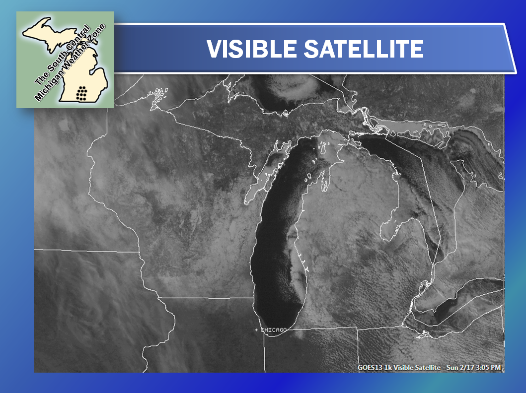
Here's a look at the satellite, most of that white you see is snow on the ground, not clouds:

And here's the current radar from Grand Rapids - not much but a lone lake-effect snow band there:

Here's the forecast for Jackson and surrounding areas including Rives Junction and Vandercook Lake:

Tonight, clear and cold, increasing clouds toward daybreak, cold, lows drop to around 10 above.  Wind swings from NW to SW 5-10 MPH, wind chills near 5 above in some spots.

Monday, becoming mostly cloudy, rain and maybe a snow shower developing late.  Temperatures climbing during the day, high 41, wind SW 6-12 MPH.

Monday night, rain and show showers wind down late, not as cold, lows roll back to 23, wind SW 6-12 MPH.

Tuesday, continued cloudy, colder, a stray flurry cannot be ruled out, high 28, wind turning NW 7-13 MPH.

Wednesday, cloudy and seasonably cold, high 28.

Thursday, still cloudy, cold, high 28.

Friday, cloudy, chance of a wintry mix or some snow, accumulations should be less than 3".  High 33.

Saturday, still cloudy, a chance of snow or freezing rain can't be eliminated, high 35.

There's a look at your forecast for the next six days, I do hope that you have a great day!  Blessings.