Good Morning!
Damp weather on the way for South Central Michigan, let's get right into what's going on!
SHOWERS & STORMS AFOOT: Current radar from the Grand Rapids NEXRAD shows a cluster of showers and thunderstorms in Kalamazoo county, just west of the blog area, and a larger mass of showers stretching all the way up from Benton Harbor to just north of Big Rapids. In addition, some showers and storms are starting to pop in the north zone of the blog, in Clinton and Shiawassee counties:
You see all of this moving east-northeast, so get the umbrellas ready.
MILD AND MUGGY FOR A BIT LONGER: A flat ridge will keep things moist humidity-wise through late Tuesday, then we should gradually see some easing of the dewpoint values back into the 60's from the 70+ values we have in the area right now. This means that you'll feel a little cooler and it will be a bit harder for showers and thunderstorms to get rolling in the area. The good news is we don't have upper 80's and 90's to add to the mix, as winds are staying primarily west-northwest, and no big heat domes out west expanding into the area right now!
WHAT ABOUT RAIN: Well, today we could see some strong or severe showers and storms with gusty wind and strong hail. Here's the SPC graphic to show that:
One other "slight" risk, over the Front Range and eastern third of Colorado into Kansas. I'm not expecting anything beyond the above for severe weather today. We'll continue to keep some shower and storm risk in the forecast until at least mid week. After that, clearing skies and seasonable for the second half of the week.
Here's the forecast:
Today - Mainly cloudy, showers and thunderstorms as the day progresses, some could be gusty with heavy rains and possibly some small hail. High 84.
Tonight - Continued mainly cloudy, some showers and storms possible. Lows near 68.
Tuesday - Overcast skies with periods of showers and thunderstorms. High 85.
Wednesday - Slowly clearing skies, we can't rule out a lingering shower or PM storm. High 83.
Thursday - Periods of clouds and sunshine, some spots could see a stray PM shower or lonely thunderstorm. High 83.
Friday - Periods of clouds and sunshine, an isolated shower or two possible later in the day. High 83.
There's your forecast to get you the end of the work week, have a great Monday!
Monday, August 6, 2018
Friday, August 3, 2018
Back Posting - Warm Weekend On The Way
Good Morning!
Has it really been THREE MONTHS since I last posted on this blog!? That is just insane! A decision is forthcoming regarding keeping this blog open, or just moving everything over to Facebook. I personally prefer the flexibility of being able to post without being reliant on Facebook for everything, but we'll have to see what makes sense. I have changed jobs so things should be a little less hectic regarding how I actually earn my living as opposed to this, which, for the time being is just a hobby. Enough sidebar, let's get to some weather!
LOOKING QUIET THIS WEEKEND: Aside from a lonely shower or two east of the blog into Detroit, not a whole lot to see. Certainly nothing like the brief EF-0 tornado touching down in Taylor a little bit before 1 AM the other night. I expect that we'll see more clouds than sunshine today and into the weekend, so we can't rule out a pop-up PM shower or lonely thunderstorm as a result. The good news is that the really hot temperatures should stay away. The clouds are also keeping us from surging into the 90's. I expect daytime highs around 84.
HEAT IS ON FOR THE WEEKEND: The hot air does elbow it's way back in as the upper ridge rebuilds itself. Expect your weekend highs to climb to between 88 to 93 depending on how close you are to the southern border of Michigan. Just the mention of an isolated raindrop or two Saturday but that is about it.
DAMP MONDAY: The next credible chance of any widespread rain appears to be Monday, as the upper ridge positions itself more southwest of us, we'll see a couple of disturbances slide through the area, each bringing some scattered showers and a couple of thunderstorms to the party. We'll alos cool it back down to the lower 80's as well.
Here's the forecast:
Today - Periods of clouds and sun, don't be shocked by an isolated or scattered shower or storm in the PM. High 84.
Tonight - Some clouds persist, lows near 64.
Saturday - Sunshine increasing, and so do temperatures. High 89.
Sunday - Mainly sunny with some passing clouds in the PM, warmer still. High 90.
Monday - Increasing clouds, scattered showers and thunderstorms developing, cooler. High 84.
We'll have a more detailed forecast for you later. Have a good day!
Has it really been THREE MONTHS since I last posted on this blog!? That is just insane! A decision is forthcoming regarding keeping this blog open, or just moving everything over to Facebook. I personally prefer the flexibility of being able to post without being reliant on Facebook for everything, but we'll have to see what makes sense. I have changed jobs so things should be a little less hectic regarding how I actually earn my living as opposed to this, which, for the time being is just a hobby. Enough sidebar, let's get to some weather!
LOOKING QUIET THIS WEEKEND: Aside from a lonely shower or two east of the blog into Detroit, not a whole lot to see. Certainly nothing like the brief EF-0 tornado touching down in Taylor a little bit before 1 AM the other night. I expect that we'll see more clouds than sunshine today and into the weekend, so we can't rule out a pop-up PM shower or lonely thunderstorm as a result. The good news is that the really hot temperatures should stay away. The clouds are also keeping us from surging into the 90's. I expect daytime highs around 84.
HEAT IS ON FOR THE WEEKEND: The hot air does elbow it's way back in as the upper ridge rebuilds itself. Expect your weekend highs to climb to between 88 to 93 depending on how close you are to the southern border of Michigan. Just the mention of an isolated raindrop or two Saturday but that is about it.
DAMP MONDAY: The next credible chance of any widespread rain appears to be Monday, as the upper ridge positions itself more southwest of us, we'll see a couple of disturbances slide through the area, each bringing some scattered showers and a couple of thunderstorms to the party. We'll alos cool it back down to the lower 80's as well.
Here's the forecast:
Today - Periods of clouds and sun, don't be shocked by an isolated or scattered shower or storm in the PM. High 84.
Tonight - Some clouds persist, lows near 64.
Saturday - Sunshine increasing, and so do temperatures. High 89.
Sunday - Mainly sunny with some passing clouds in the PM, warmer still. High 90.
Monday - Increasing clouds, scattered showers and thunderstorms developing, cooler. High 84.
We'll have a more detailed forecast for you later. Have a good day!
Wednesday, May 2, 2018
Springy And Wet....
Good Morning!
Burning the late night oil for a potentially busy day weather wise in Michigan after going through the first seasonably warm taste of Spring/ (maybe even summer) in the area yesterday, with highs in the upper 70's and low 80's throughout the blog area with plenty of sunshine! Changes are coming early tomorrow, and a chance of severe weather is in the mix as well. Let's pop the hood and see what's running under there...
MARGINAL RISK FOR SEVERE: Right off, I need to tell you that the Storm Prediction Center has placed most of the southern half of lower Michigan in a "Marginal" risk for severe weather tomorrow. The good news is that I don't expect any tornadic weather out of this.
Taking a look at the SPC Outlook (this is Day 2, it will update at 8 AM), you see the southern half of Lower Michigan, excluding the thumb, in the Marginal. Better chances for severe are just across the lake stretching from Chicago, back to places like Kansas City, Wichita, Oklahoma City, and down into Texas and points further southwest.
MORE SEVERE DETAIL: Forecast data shows an upper disturbance working though the northern half of the Lower Peninsula this morning, and consistent with that, any rain and such appears to be confined to areas north of a line from say, Muskegon to Saginaw, so your AM and PM drives should be OK. After dinner around the late news is the time to be concerned with. Let's look at another graphic...
Here's a look at the hi-res NAM forecast model. You can see that at 11 PM tomorrow, just a few thunderstorms between I-94 and I-96, and Detroit having a bit better concentration of them. The better chance for showers and storms will be just into the northern half of the Lower Peninsula, with a second shot of showers and storms working more into South Central Michigan pre-dawn Thursday. I still don't think we see anything tornadic, but we'll have to check the data as the day progresses.
PRECIPITATION AMOUNTS: The second hit of showers and storms will bring the more robust precipitation amounts into South Central Michigan. When we take a look at the precipitation map, we see...
The rain forecast thru Saturday, or Cinco De Mayo, is about 1.5", some spots will be locally higher or lower depending on storm track. Again, we'll need to look at the data and satellite and such tomorrow to get a better idea of how things will play out.
Here's the forecast:
Today - Early sun gives way to mainly cloudy skies, a pop-up shower or storm can't be ruled out. High 82.
Tonight - Cloudy, developing showers and thunderstorms late, some could be strong or severe. Lows near 60.
Thursday - Cloudy, scattered to numerous showers and thunderstorms, a bit cooler, with the high near 78.
Friday - Continued cloudy with scattered showers and perhaps a lingering storm or two. High 76.
Saturday - Clearing skies with some PM sunshine and seasonable. High 76.
Sunday - Cloudy skies, periods of showers and perhaps a thunderstorm in spots. High only 64.
Monday - Sunny and seasonable. High 67.
I hope that you have a great Hump Day!
Burning the late night oil for a potentially busy day weather wise in Michigan after going through the first seasonably warm taste of Spring/ (maybe even summer) in the area yesterday, with highs in the upper 70's and low 80's throughout the blog area with plenty of sunshine! Changes are coming early tomorrow, and a chance of severe weather is in the mix as well. Let's pop the hood and see what's running under there...
MARGINAL RISK FOR SEVERE: Right off, I need to tell you that the Storm Prediction Center has placed most of the southern half of lower Michigan in a "Marginal" risk for severe weather tomorrow. The good news is that I don't expect any tornadic weather out of this.
Taking a look at the SPC Outlook (this is Day 2, it will update at 8 AM), you see the southern half of Lower Michigan, excluding the thumb, in the Marginal. Better chances for severe are just across the lake stretching from Chicago, back to places like Kansas City, Wichita, Oklahoma City, and down into Texas and points further southwest.
MORE SEVERE DETAIL: Forecast data shows an upper disturbance working though the northern half of the Lower Peninsula this morning, and consistent with that, any rain and such appears to be confined to areas north of a line from say, Muskegon to Saginaw, so your AM and PM drives should be OK. After dinner around the late news is the time to be concerned with. Let's look at another graphic...
Here's a look at the hi-res NAM forecast model. You can see that at 11 PM tomorrow, just a few thunderstorms between I-94 and I-96, and Detroit having a bit better concentration of them. The better chance for showers and storms will be just into the northern half of the Lower Peninsula, with a second shot of showers and storms working more into South Central Michigan pre-dawn Thursday. I still don't think we see anything tornadic, but we'll have to check the data as the day progresses.
PRECIPITATION AMOUNTS: The second hit of showers and storms will bring the more robust precipitation amounts into South Central Michigan. When we take a look at the precipitation map, we see...
The rain forecast thru Saturday, or Cinco De Mayo, is about 1.5", some spots will be locally higher or lower depending on storm track. Again, we'll need to look at the data and satellite and such tomorrow to get a better idea of how things will play out.
Here's the forecast:
Today - Early sun gives way to mainly cloudy skies, a pop-up shower or storm can't be ruled out. High 82.
Tonight - Cloudy, developing showers and thunderstorms late, some could be strong or severe. Lows near 60.
Thursday - Cloudy, scattered to numerous showers and thunderstorms, a bit cooler, with the high near 78.
Friday - Continued cloudy with scattered showers and perhaps a lingering storm or two. High 76.
Saturday - Clearing skies with some PM sunshine and seasonable. High 76.
Sunday - Cloudy skies, periods of showers and perhaps a thunderstorm in spots. High only 64.
Monday - Sunny and seasonable. High 67.
I hope that you have a great Hump Day!
Thursday, April 12, 2018
Changes Coming For The Weekend!
Good Morning!
Some shower activity in the area right now, with clouds in a good portion of South Central Michigan. We'll see some big changes coming int he next couple of days, so let's dive in and see what we have going!
MILD AND A SHOWER: Currently in the area we have plenty of clouds, with some showers in the far south zone, Hillsdale and Coldwater for example. Temperatures in the mid and upper 40's, with Jackson checking on at 47 and Lansing 48. Other than that all of the precipitation is inthe northern half of the Lower Peninsula.
FAIRLY QUIET TODAY: Even with the clouds and such around, I don't expect much more in the way of precipitation or anything like that today, perhaps an isolated to widely scattered shower later this evening, but that's about it. Temperatures should top out in the mid to upper 60's. Some spots will see a 70 or two. Mild and spring-like for sure.
NEXT WEATHER MAKER: Our next system will start working in tomorrow afternoon and evening, and Saturday we'll wake up to cooler conditions, with showers and possibly a couple of thunderstorms during the overnight hours into Saturday. I don't anticipate any of this activity being severe, but we will see temperatures dropping as a result back into the 60's and lower as we work through the weekend.
Here's the forecast:
Today - Cloudy and mild, we can't rule out an isolated PM shower. High 68.
Tonight - Continued overcast, still above average temperatures that only roll back to 48.
Friday - Cloudy, scattered PM showers and perhaps a storm developing. High 67.
Saturday - Overcast and damp - scattered to numerous showers. Cooler. High only 57.
Sunday - Clouds and rainy - cooler still. High only 46.
We'll work on getting you an extended forecast up later on. Have a great day!
Some shower activity in the area right now, with clouds in a good portion of South Central Michigan. We'll see some big changes coming int he next couple of days, so let's dive in and see what we have going!
MILD AND A SHOWER: Currently in the area we have plenty of clouds, with some showers in the far south zone, Hillsdale and Coldwater for example. Temperatures in the mid and upper 40's, with Jackson checking on at 47 and Lansing 48. Other than that all of the precipitation is inthe northern half of the Lower Peninsula.
FAIRLY QUIET TODAY: Even with the clouds and such around, I don't expect much more in the way of precipitation or anything like that today, perhaps an isolated to widely scattered shower later this evening, but that's about it. Temperatures should top out in the mid to upper 60's. Some spots will see a 70 or two. Mild and spring-like for sure.
NEXT WEATHER MAKER: Our next system will start working in tomorrow afternoon and evening, and Saturday we'll wake up to cooler conditions, with showers and possibly a couple of thunderstorms during the overnight hours into Saturday. I don't anticipate any of this activity being severe, but we will see temperatures dropping as a result back into the 60's and lower as we work through the weekend.
Here's the forecast:
Today - Cloudy and mild, we can't rule out an isolated PM shower. High 68.
Tonight - Continued overcast, still above average temperatures that only roll back to 48.
Friday - Cloudy, scattered PM showers and perhaps a storm developing. High 67.
Saturday - Overcast and damp - scattered to numerous showers. Cooler. High only 57.
Sunday - Clouds and rainy - cooler still. High only 46.
We'll work on getting you an extended forecast up later on. Have a great day!
Wednesday, April 11, 2018
Quick Hump Day Review...
Good Morning!
With a few minutes to spare before the day job starts, let's tap into the weather plan for the next few days...
DAMP TONIGHT - We'll see clouds thickening as the day progresses, with the approach from the west of an upper disturbance that will bring showers and perhaps an embedded thunderstorm or two. Daytime highs today should be about 56, and the rains will move in anytime after 9 PM. The good news is that they don't stay around too long, and while you may still have some rain to deal with for AM drive tomorrow, I don't expect anything really crazy.
PERHAPS A BIT MORE FRIDAY - Forecast data is suggesting that we may get visited by a second round of precipitation for Friday. This appears to be more widely spaced shower activity, though I can't rule out a possible hit and run thunderstorm as well. We'll see highs drop after this wave of precipitation as we are...
COOLING DOWN FOR THE WEEKEND: We'll be giving back roughly 15-20 degrees of high temperature for the weekend. We'll be into the upper 60's for Friday, some spots could post a 70, then that's all you see of those right through the forecast window. We'll drop back into the 40's/low 50's regime. The only positive to this is I don't see any real risk for snow of any consequence during the period.
Here's the forecast for Jackson and surrounding areas including Rives Junction and Concord.
Today - Mainly cloudy, any peeks of sun go away by early afternoon. High 54.
Tonight - Rain moving in, with a possible pre-dawn thunderstorm. Lows near 46.
Thursday - Continued overcast with a stray shower possible in a spot or two. Warmer, high 68.
Friday - Cloudy, but the warmest day of the forecast period. Again, we cannot eliminate the mention of a couple of periods of showers. High 71.
Saturday - Cloudy and sharply cooler, scattered to numerous showers and maybe a lonely thunderstorm. High only 54.
Sunday - Cloudy, damp, rainy. High 51.
Monday - Still little to no sunshine, temperatures cooling further, rain or snow showers depending on your location. High of only 44.
Tuesday - Lots of clouds, very little sun, a touch warmer. High 52.
I hope that you have a great Wednesday!
With a few minutes to spare before the day job starts, let's tap into the weather plan for the next few days...
DAMP TONIGHT - We'll see clouds thickening as the day progresses, with the approach from the west of an upper disturbance that will bring showers and perhaps an embedded thunderstorm or two. Daytime highs today should be about 56, and the rains will move in anytime after 9 PM. The good news is that they don't stay around too long, and while you may still have some rain to deal with for AM drive tomorrow, I don't expect anything really crazy.
PERHAPS A BIT MORE FRIDAY - Forecast data is suggesting that we may get visited by a second round of precipitation for Friday. This appears to be more widely spaced shower activity, though I can't rule out a possible hit and run thunderstorm as well. We'll see highs drop after this wave of precipitation as we are...
COOLING DOWN FOR THE WEEKEND: We'll be giving back roughly 15-20 degrees of high temperature for the weekend. We'll be into the upper 60's for Friday, some spots could post a 70, then that's all you see of those right through the forecast window. We'll drop back into the 40's/low 50's regime. The only positive to this is I don't see any real risk for snow of any consequence during the period.
Here's the forecast for Jackson and surrounding areas including Rives Junction and Concord.
Today - Mainly cloudy, any peeks of sun go away by early afternoon. High 54.
Tonight - Rain moving in, with a possible pre-dawn thunderstorm. Lows near 46.
Thursday - Continued overcast with a stray shower possible in a spot or two. Warmer, high 68.
Friday - Cloudy, but the warmest day of the forecast period. Again, we cannot eliminate the mention of a couple of periods of showers. High 71.
Saturday - Cloudy and sharply cooler, scattered to numerous showers and maybe a lonely thunderstorm. High only 54.
Sunday - Cloudy, damp, rainy. High 51.
Monday - Still little to no sunshine, temperatures cooling further, rain or snow showers depending on your location. High of only 44.
Tuesday - Lots of clouds, very little sun, a touch warmer. High 52.
I hope that you have a great Wednesday!
Tuesday, April 3, 2018
Severe Weather Possible Today...
Good Morning!
Just enough time to let you know that today South Central Michigan is under a "marginal" risk for severe weather according to the Storm Prediction Center. Have a look at the map below:
About the only counties in the blog area that are not impacted by this are Clinton and Shiawassee. All other counties are included. Fortunately I do not expect any tornadic severe weather, but what I do expect is a marching line of strong to severe storms with some damaging straight-line winds and some hail, potentially up to quarter sized as the main threats. That being said, please have a way to get any warnings and know what to do if you come under one. And while I said I don't expect any tornadic weather, quick spin-up tornadoes can and do like to hide in a line of storms. We'll have to see if we get any cellular storms to start before the line organizes and starts marching, and we won't know about that until we see how the atmosphere recovers and resets from the AM showers and such that moved through.
Stay weather aware and be safe today!
Monday, April 2, 2018
Springtime Severe On The Way?
Good Morning!
South Central Michigan could see it's first spring severe weather tomorrow afternoon and evening. Let's get right into it.
NOT MUCH TO WORRY WITH TODAY: We don't have a whole lot to concern ourselves with today, as I expect mainly clear and chilly, but tomorrow will be a whole different issue.
STORMS TOMORROW: With the approach of a low that's starting it's trip on the eastern plains of Colorado today, skies will cloud up and moisture streaming north from the Gulf Of Mexico will run into the low and we'll see some showers and thunderstorms, some of these could be locally strong or severe, with gusty winds and possibly a bit of hail. The stronger dynamics that would up the ante for severe are south of Michigan, back into Indiana and further southwest. Have a look at these maps...
You can also see that the system will already be working on our weather just to the southwest, with a marginal risk for severe today being outlined by the Storm Prediction Center.
OK, WHAT ABOUT THE WEATHER TOMORROW?: Tomorrow's weather will be unsettled. The feature I referenced above that will touch off the severe weather in our part of the world will also raise temperatures into the 50's with it, thanks to the southerly flow that will be bringing all that moisture up here. You wouldn't have to go much further north than say Muskegon or Clare to find snow though! Up in the northern edge of this system in the cold sector, snow will be falling. As it stands now I don't think we see any in South Central Michigan, we'll re-check that tomorrow.
Quick forecast for the next three days for you, then the straight job awaits....
Today - Increasing clouds, seasonable. High 46.
Tonight - Cloudy, some widely scattered showers are possible. Low 33.
Tuesday - Cloudy, a couple of AM showers, then PM showers and storms developing, especially along and south of I-94, some could be locally strong to severe. High 50.
Wednesday - Continued cloudy and colder, high only 38.
Have a great Monday!
South Central Michigan could see it's first spring severe weather tomorrow afternoon and evening. Let's get right into it.
NOT MUCH TO WORRY WITH TODAY: We don't have a whole lot to concern ourselves with today, as I expect mainly clear and chilly, but tomorrow will be a whole different issue.
STORMS TOMORROW: With the approach of a low that's starting it's trip on the eastern plains of Colorado today, skies will cloud up and moisture streaming north from the Gulf Of Mexico will run into the low and we'll see some showers and thunderstorms, some of these could be locally strong or severe, with gusty winds and possibly a bit of hail. The stronger dynamics that would up the ante for severe are south of Michigan, back into Indiana and further southwest. Have a look at these maps...
You can also see that the system will already be working on our weather just to the southwest, with a marginal risk for severe today being outlined by the Storm Prediction Center.
OK, WHAT ABOUT THE WEATHER TOMORROW?: Tomorrow's weather will be unsettled. The feature I referenced above that will touch off the severe weather in our part of the world will also raise temperatures into the 50's with it, thanks to the southerly flow that will be bringing all that moisture up here. You wouldn't have to go much further north than say Muskegon or Clare to find snow though! Up in the northern edge of this system in the cold sector, snow will be falling. As it stands now I don't think we see any in South Central Michigan, we'll re-check that tomorrow.
Quick forecast for the next three days for you, then the straight job awaits....
Today - Increasing clouds, seasonable. High 46.
Tonight - Cloudy, some widely scattered showers are possible. Low 33.
Tuesday - Cloudy, a couple of AM showers, then PM showers and storms developing, especially along and south of I-94, some could be locally strong to severe. High 50.
Wednesday - Continued cloudy and colder, high only 38.
Have a great Monday!
Sunday, March 11, 2018
Quick Look For The New Week...
Good Afternoon!
Still seasonably cold in the area with a Canadian Special bringing us cold northerly flow out from north of the border. We expect this pattern to persist for the next few days, then we'll start to see some changes around mid-week. Let's have a look and see what's going on...
A PAIR OF PLAYERS: Two players on the field to be concerned about. The first is an upper low currently over eastern Nebraska/western Iowa, that will become a closed low over the next several hours and progress southeasterly. That is responsible for the Winter Weather Advisories and Winter Storm Warnings well to our south.
The second player is another upper low that is a fair ways into Canada. It's currently several hundred miles northwest of us, but I expect it to be here at some point on Tuesday based on the available forecast data.
WHAT DO THEY DO?: Well, the upper low heading southeast doesn't directly impact us itself, but it does appear that it will change up the track of the Canadian upper low a little bit in our favor. Additionally, this low is the one that New York and New England were concerned would be the third nor'easter in 2 weeks, but the forecast data is indicating that he'll just march right out to sea and keep on going - so no wraparound snow or anything like that to worry about.
The second one in Canada right now? 1) He'll keep cold air working into Michigan until the latter part of the week; 2) Tomorrow night into Tuesday, we'll see the chance of a few flurries or some light snow. I don't really think we'll see a ton in the way of accumulation because there's not a whole lot of moist air for this system to work with.
WARMING UP: Good news! Milder conditions are on the way. I expect to see some 50's and possibly a 60 or two around the area for the weekend. Enjoy it because things change again to start the new work week!
A NEW SHOT OF PRECIPITATION: I expect us to see some sun on Monday, but clouds will thicken as the next weather-maker approaches us from the east. We'll also be close enough to the leading edge of some cold air that there is some uncertainty at this time as to whether we'll be seeing all rain, all snow, or a wintry mix. Behind that, temperatures will be falling back into a more winter-like range with clearing as well.
Here's the forecast:
This evening: Increasing clouds as the night wears on, lows roll back to near 22.
Monday - More clouds than sunshine, seasonable, high 39.
Monday Night - Cloudy with a chance of some light snow - lows near 21.
Tuesday - Partly cloudy and chilly, high near 37.
Wednesday - Partly cloudy, high 43.
Thursday - A mix of clouds and sun, not as cold, high 48.
Friday - Mainly sunny and warmer, high 51.
Have a great rest of your Sunday
Still seasonably cold in the area with a Canadian Special bringing us cold northerly flow out from north of the border. We expect this pattern to persist for the next few days, then we'll start to see some changes around mid-week. Let's have a look and see what's going on...
A PAIR OF PLAYERS: Two players on the field to be concerned about. The first is an upper low currently over eastern Nebraska/western Iowa, that will become a closed low over the next several hours and progress southeasterly. That is responsible for the Winter Weather Advisories and Winter Storm Warnings well to our south.
The second player is another upper low that is a fair ways into Canada. It's currently several hundred miles northwest of us, but I expect it to be here at some point on Tuesday based on the available forecast data.
WHAT DO THEY DO?: Well, the upper low heading southeast doesn't directly impact us itself, but it does appear that it will change up the track of the Canadian upper low a little bit in our favor. Additionally, this low is the one that New York and New England were concerned would be the third nor'easter in 2 weeks, but the forecast data is indicating that he'll just march right out to sea and keep on going - so no wraparound snow or anything like that to worry about.
The second one in Canada right now? 1) He'll keep cold air working into Michigan until the latter part of the week; 2) Tomorrow night into Tuesday, we'll see the chance of a few flurries or some light snow. I don't really think we'll see a ton in the way of accumulation because there's not a whole lot of moist air for this system to work with.
WARMING UP: Good news! Milder conditions are on the way. I expect to see some 50's and possibly a 60 or two around the area for the weekend. Enjoy it because things change again to start the new work week!
A NEW SHOT OF PRECIPITATION: I expect us to see some sun on Monday, but clouds will thicken as the next weather-maker approaches us from the east. We'll also be close enough to the leading edge of some cold air that there is some uncertainty at this time as to whether we'll be seeing all rain, all snow, or a wintry mix. Behind that, temperatures will be falling back into a more winter-like range with clearing as well.
Here's the forecast:
This evening: Increasing clouds as the night wears on, lows roll back to near 22.
Monday - More clouds than sunshine, seasonable, high 39.
Monday Night - Cloudy with a chance of some light snow - lows near 21.
Tuesday - Partly cloudy and chilly, high near 37.
Wednesday - Partly cloudy, high 43.
Thursday - A mix of clouds and sun, not as cold, high 48.
Friday - Mainly sunny and warmer, high 51.
Have a great rest of your Sunday
Friday, February 23, 2018
Will We Be Able To Dry Out?
Good Morning!
Too much water in the area! Multiple rivers are out of their banks and flooding is a problem in multiple places across South Central Michigan. Here's a quick look for you!
FLOOD WARNINGS AND SUCH: A good chunk of the area is under Flood Warnings, but there is also a fair amount in the blog coverage areas that is NOT. Branch, Hillsdale, Lenawee, Washtenaw, Livingston, Shiawassee have either no warning, or just the part of the county near a riverbed is impacted. All other counties in the blog area are under Flood Warnings until further notice.
CHANGES COMING: The trough that has the western US cold and snow covered, and also touching off some stormy weather to our south, will finally begin to ever so slowly creep eastward over the next 24 hours or so. Looking back up at the map, you see all the blue shading for the Winter Weather Advisories that stretch from the Upper Peninsula all the way down into western Texas. All of that will slowly start to migrate this way over the weekend, and I suspect that it will lose a bit of steam as it marches this way.
SUMMARY: We'll need to put up with the rain and such for another 48 hours or so, then as we get into late Sunday and Monday for the new work week, we'll finally clear out the skies and give everyone a chance to dry out a bit! Those conditions should last into mid-week, when the next system works into the area, increasing the chances to pick up more rain and such.
Here's the forecast for Jackson and surrounding areas including Michigan Center and Parma:
Today - Cloudy, periods of rain and showers, high 48.
Tonight - More clouds and still rainy at times, but any showers will diminish, lows roll back to 31.
Saturday - Mainly cloudy, a lonely shower or two can't be ruled out, high 47.
Sunday - AM clouds should give way to PM sunshine, seasonable. High 48.
Monday - Mainly sunny and a touch warmer than the weekend, high 51.
Tuesday - Sunshine, conditions will remind you of early Spring. High 53.
Wednesday - Increasing clouds with a couple of PM showers possible, a bit cooler, high 47.
Thursday - Cloudy with scattered to numerous showers. High only 46.
There's a look at your forecast, I hope that you have a great Friday!
Too much water in the area! Multiple rivers are out of their banks and flooding is a problem in multiple places across South Central Michigan. Here's a quick look for you!
FLOOD WARNINGS AND SUCH: A good chunk of the area is under Flood Warnings, but there is also a fair amount in the blog coverage areas that is NOT. Branch, Hillsdale, Lenawee, Washtenaw, Livingston, Shiawassee have either no warning, or just the part of the county near a riverbed is impacted. All other counties in the blog area are under Flood Warnings until further notice.
CHANGES COMING: The trough that has the western US cold and snow covered, and also touching off some stormy weather to our south, will finally begin to ever so slowly creep eastward over the next 24 hours or so. Looking back up at the map, you see all the blue shading for the Winter Weather Advisories that stretch from the Upper Peninsula all the way down into western Texas. All of that will slowly start to migrate this way over the weekend, and I suspect that it will lose a bit of steam as it marches this way.
SUMMARY: We'll need to put up with the rain and such for another 48 hours or so, then as we get into late Sunday and Monday for the new work week, we'll finally clear out the skies and give everyone a chance to dry out a bit! Those conditions should last into mid-week, when the next system works into the area, increasing the chances to pick up more rain and such.
Here's the forecast for Jackson and surrounding areas including Michigan Center and Parma:
Today - Cloudy, periods of rain and showers, high 48.
Tonight - More clouds and still rainy at times, but any showers will diminish, lows roll back to 31.
Saturday - Mainly cloudy, a lonely shower or two can't be ruled out, high 47.
Sunday - AM clouds should give way to PM sunshine, seasonable. High 48.
Monday - Mainly sunny and a touch warmer than the weekend, high 51.
Tuesday - Sunshine, conditions will remind you of early Spring. High 53.
Wednesday - Increasing clouds with a couple of PM showers possible, a bit cooler, high 47.
Thursday - Cloudy with scattered to numerous showers. High only 46.
There's a look at your forecast, I hope that you have a great Friday!
Sunday, February 11, 2018
Winter's Usual Pattern...
Good Evening!
Has it really been over 8 months since I have posted on this blog!? WOW! I guess when you're working 2 jobs to pay the bills that's what happens. At any rate, looking like some moderation and relief from the bone numbing cold is on the way. Let's have a look and see what's going on...
CLOUDS MOVING OUT - SLOWLY: Infrared satellite shows clouds slowing working through Michigan with westerly winds pushing. We note the Canadian air coming in behind all of this as well...
Readings currently in the 20's at all reporting stations with varying degrees of cloudiness at this hour.
STILL COLD: We'll get the clouds out of here and then the cold Canadian air is free to roll in. Single digit lows will greet you as you head out the door to work in the morning, with subzero wind chills, all the way down to near 10 below zero! Fortunately those won't stick around long enough to present any sort of issue where a Wind Chill Warning is needed - at least not right now. That will be the pattern for the next few days, with daytime highs not getting out of the 20's and lows in the single digits, with wind chills making it feel like zero or worse until Wednesday.
MIDWEEK MODERATION: Temperatures will finally get north of freezing mid week, with daytime highs around South Central Michigan set to get into the mid to upper 30's, and some areas may even stretch into the 40's. Positively balmy as compared to what's going on now! Forecast data is suggesting a high of 45 in Jackson for Wednesday, but I think that's a bit ambitious on the model's part. I'll say 40-43 would work though. The bad news is those readings stick around for only a day or two, then back to the daytime highs in the 20's and very cold nights bit again. The next chance for any moderation appears to be Sunday.
PRECIPITATION: Coincident with the brief warm-up mid-week, we'll need to introduce the chance of some rain into the picture as well. I would say anywhere from a 3 in 10 to 50 - 50 chance of some showers would fill the bill.
LOOKING AHEAD: The full scoop is still a ways off, but mid week next week, the Tuesday/Wed timeframe, forecast data is suggesting the chance of a wintry mix of precipitation. Be aware of this planning your travels next week.
Here's the forecast:
Tonight - Clearing skies and cold, lows roll back to near 11.
Monday - Mostly sunny, continued seasonably cold, highs only near 28.
Monday Night - Mainly clear, some passing clouds - very cold. Lows down to 6 with wind chills below zero likely.
Tuesday - Partly to mainly sunny, a touch warmer, high 29.
Wednesday - More clouds than sun, chance of rain, warmer, high 43.
Thursday - Continued mainly cloudy, rain still a possibility, high 46.
Friday - Continued mainly overcast, but sharply colder as a cold front moves through, highs top out near 29.
Saturday - Clearing skies, becoming mostly sunny, warmer, high 36.
I hope you have a great evening!
Has it really been over 8 months since I have posted on this blog!? WOW! I guess when you're working 2 jobs to pay the bills that's what happens. At any rate, looking like some moderation and relief from the bone numbing cold is on the way. Let's have a look and see what's going on...
CLOUDS MOVING OUT - SLOWLY: Infrared satellite shows clouds slowing working through Michigan with westerly winds pushing. We note the Canadian air coming in behind all of this as well...
Readings currently in the 20's at all reporting stations with varying degrees of cloudiness at this hour.
STILL COLD: We'll get the clouds out of here and then the cold Canadian air is free to roll in. Single digit lows will greet you as you head out the door to work in the morning, with subzero wind chills, all the way down to near 10 below zero! Fortunately those won't stick around long enough to present any sort of issue where a Wind Chill Warning is needed - at least not right now. That will be the pattern for the next few days, with daytime highs not getting out of the 20's and lows in the single digits, with wind chills making it feel like zero or worse until Wednesday.
MIDWEEK MODERATION: Temperatures will finally get north of freezing mid week, with daytime highs around South Central Michigan set to get into the mid to upper 30's, and some areas may even stretch into the 40's. Positively balmy as compared to what's going on now! Forecast data is suggesting a high of 45 in Jackson for Wednesday, but I think that's a bit ambitious on the model's part. I'll say 40-43 would work though. The bad news is those readings stick around for only a day or two, then back to the daytime highs in the 20's and very cold nights bit again. The next chance for any moderation appears to be Sunday.
PRECIPITATION: Coincident with the brief warm-up mid-week, we'll need to introduce the chance of some rain into the picture as well. I would say anywhere from a 3 in 10 to 50 - 50 chance of some showers would fill the bill.
LOOKING AHEAD: The full scoop is still a ways off, but mid week next week, the Tuesday/Wed timeframe, forecast data is suggesting the chance of a wintry mix of precipitation. Be aware of this planning your travels next week.
Here's the forecast:
Tonight - Clearing skies and cold, lows roll back to near 11.
Monday - Mostly sunny, continued seasonably cold, highs only near 28.
Monday Night - Mainly clear, some passing clouds - very cold. Lows down to 6 with wind chills below zero likely.
Tuesday - Partly to mainly sunny, a touch warmer, high 29.
Wednesday - More clouds than sun, chance of rain, warmer, high 43.
Thursday - Continued mainly cloudy, rain still a possibility, high 46.
Friday - Continued mainly overcast, but sharply colder as a cold front moves through, highs top out near 29.
Saturday - Clearing skies, becoming mostly sunny, warmer, high 36.
I hope you have a great evening!
Sunday, July 23, 2017
Quick Severe Weather Update
Good Afternoon!
Updating the severe weather potential part of the forecast for you. The Storm Prediction Center has trimmed out the western half of Michigan from the slight risk area, but the are keeping it in for the eastern half of Michigan. The area that was trimmed out though, is west of US-131, so we still could see some severe weather with gusty winds and marginally severe hail.
We haven't been able to heat up as much as I had expected just yet, because some lingering mid to high clouds have kept some of the sun out of here. This will mitigate the severe threat somewhat as well. We'll still need to keep watch for severe storms, but these will be after probably 3 PM, a bit less widespread than initially expected, and gusty outflow winds will be the main threat.
Stay weather aware!
Updating the severe weather potential part of the forecast for you. The Storm Prediction Center has trimmed out the western half of Michigan from the slight risk area, but the are keeping it in for the eastern half of Michigan. The area that was trimmed out though, is west of US-131, so we still could see some severe weather with gusty winds and marginally severe hail.
We haven't been able to heat up as much as I had expected just yet, because some lingering mid to high clouds have kept some of the sun out of here. This will mitigate the severe threat somewhat as well. We'll still need to keep watch for severe storms, but these will be after probably 3 PM, a bit less widespread than initially expected, and gusty outflow winds will be the main threat.
Stay weather aware!
Cooling Down After Some Stormy Weather
Good Evening!
We'll see some changes in the weather pattern over the next day or two, but we need to get through a period of potentially rough weather first. Let's dive in and have a quick look at it.
SLIGHT SEVERE RISK TODAY: We note that the Storm Prediction Center has placed all of lower Michigan into a risk category of some type. Here in South Central Michigan, we see the standard "slight" risk for severe weather...
And a "marginal" risk identified for the northern part of the Lower Peninsula and the eastern Upper Peninsula. The main threat would be damaging wind, marginally severe hail, and some heavy downpours. I am NOT seeing where we would have tornado issues to worry about. I would be close to good source of weather information tomorrow afternoon though.
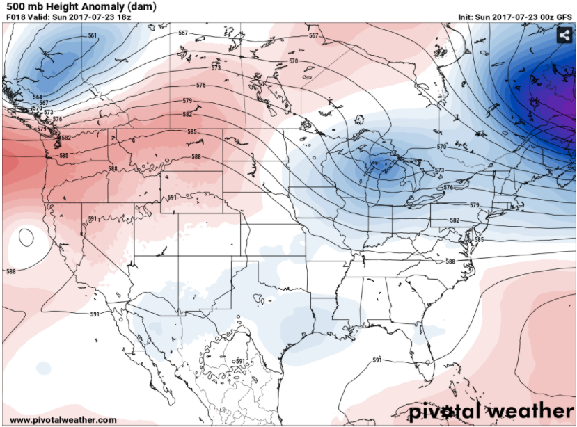
BIG PICTURE: Taking a look at the upper air setup, we see primarily zonal flow (west to east winds) up at about thirty thousand feet plus. Coming down toward the ground, at around 18,000 feet, we have a ridge west/trough east setup, and all of the weather makers coming on-shore via the Pacific Northwest immediately get re-routed up through Canada and then slide down the back of the ridge...
The blue shading over Michigan indicates an upper disturbance that came down the back side of the ridge via the Dakotas, Minnesota, and Wisconsin. Again, while some severe weather is possible, the better chances of this should remain north of us, I would say from St. Johns north is where the action would be. We'll have to see how the fine details set up though - any boundaries and such over the state, the amount of daytime heating, these kind of things.
DETAILS, DETAILS: Any shower or thunderstorm activity appears to be most likely to start sometime after 2 pm. The main body of the storms should slide well north. I would think that way up by the international border is the best bet.
AFTER THE FRONT MOVES BY: We'll see cooler, more comfortable conditions with readings in the upper 70's to lower 80's for a couple of days before the warmer weather moves back into Michigan on Wednesday, which also lines up with our next credible chance at some showers and storms. Looking down the line, forecast model data is suggesting that we will start August not in the dog days pattern,, with lower dew point values and readings holding in the lower 80's. In other words, seasonable to start the tail end of summer 2017.
Here's the forecast for South Central Michigan including Jackson, Michigan Center, and Springport:
Tonight - More clouds than stars, seasonably mild, low near 66.
Sunday - AM sunshine, clouds increase as the day progresses, PM showers and storms developing, some of these could be severe. High 87.
Sunday Night - Skies clearing slowly, any rain in the area should be gone around 11 PM. Lows near 63.
Monday - Mainly clear and cooler. High 78.
Tuesday - Continued mostly sunny and comfortable. High 81.
Wednesday - Clouds on the increase as the day progresses, some PM showers and perhaps an isolated or widely scattered thunderstorm. Warmer, high 86.
Thursday - Mixed sunshine and perhaps a couple of widely scattered showers, a touch cooler. High 82.
Friday - Sunny and pleasant. High 81.
There's your forecast, have a great one!
We'll see some changes in the weather pattern over the next day or two, but we need to get through a period of potentially rough weather first. Let's dive in and have a quick look at it.
SLIGHT SEVERE RISK TODAY: We note that the Storm Prediction Center has placed all of lower Michigan into a risk category of some type. Here in South Central Michigan, we see the standard "slight" risk for severe weather...
And a "marginal" risk identified for the northern part of the Lower Peninsula and the eastern Upper Peninsula. The main threat would be damaging wind, marginally severe hail, and some heavy downpours. I am NOT seeing where we would have tornado issues to worry about. I would be close to good source of weather information tomorrow afternoon though.
BIG PICTURE: Taking a look at the upper air setup, we see primarily zonal flow (west to east winds) up at about thirty thousand feet plus. Coming down toward the ground, at around 18,000 feet, we have a ridge west/trough east setup, and all of the weather makers coming on-shore via the Pacific Northwest immediately get re-routed up through Canada and then slide down the back of the ridge...
The blue shading over Michigan indicates an upper disturbance that came down the back side of the ridge via the Dakotas, Minnesota, and Wisconsin. Again, while some severe weather is possible, the better chances of this should remain north of us, I would say from St. Johns north is where the action would be. We'll have to see how the fine details set up though - any boundaries and such over the state, the amount of daytime heating, these kind of things.
DETAILS, DETAILS: Any shower or thunderstorm activity appears to be most likely to start sometime after 2 pm. The main body of the storms should slide well north. I would think that way up by the international border is the best bet.
AFTER THE FRONT MOVES BY: We'll see cooler, more comfortable conditions with readings in the upper 70's to lower 80's for a couple of days before the warmer weather moves back into Michigan on Wednesday, which also lines up with our next credible chance at some showers and storms. Looking down the line, forecast model data is suggesting that we will start August not in the dog days pattern,, with lower dew point values and readings holding in the lower 80's. In other words, seasonable to start the tail end of summer 2017.
Here's the forecast for South Central Michigan including Jackson, Michigan Center, and Springport:
Tonight - More clouds than stars, seasonably mild, low near 66.
Sunday - AM sunshine, clouds increase as the day progresses, PM showers and storms developing, some of these could be severe. High 87.
Sunday Night - Skies clearing slowly, any rain in the area should be gone around 11 PM. Lows near 63.
Monday - Mainly clear and cooler. High 78.
Tuesday - Continued mostly sunny and comfortable. High 81.
Wednesday - Clouds on the increase as the day progresses, some PM showers and perhaps an isolated or widely scattered thunderstorm. Warmer, high 86.
Thursday - Mixed sunshine and perhaps a couple of widely scattered showers, a touch cooler. High 82.
Friday - Sunny and pleasant. High 81.
There's your forecast, have a great one!
Sunday, April 30, 2017
Drying Out Midweek...
Good Morning!
Plenty of shower and thunderstorm activity in the area this morning, fortunately, not a big deal aside from the continuing rain causing some flooding issues over the next few days. Let's have a look at it all:
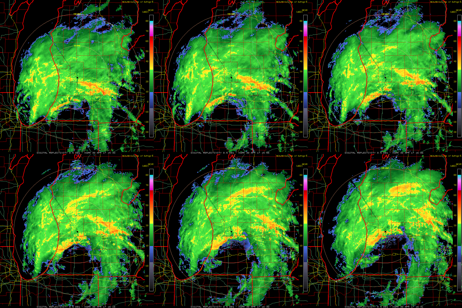
RAINY NOW: A look at the Grand Rapids NEXRAD radar loop for the last hour or so shows those showers and storms working into and through the area...
Plenty of shower and thunderstorm activity in the area this morning, fortunately, not a big deal aside from the continuing rain causing some flooding issues over the next few days. Let's have a look at it all:
RAINY NOW: A look at the Grand Rapids NEXRAD radar loop for the last hour or so shows those showers and storms working into and through the area...
You can see the core of the low tracking north-northeast, with the dry slot working up toward Calhoun and Ingham counties. That will allow a bit of a breather, but wrap around precipitation on the back side will fill in soon thereafter. At least it's not cold enough that we have to worry about snow.
SEASONABLE TEMPERATURES: Average high in the are this time of year is right about 66 degrees, and except for a cool snap Monday and Tuesday, we'll be in the ballpark. Mid 60's, then a dip into the 50's for Tuesday and Wednesday and then we get back into the seasonal range.
WHAT ABOUT PRECIPITATION: Well, the showers and such are going to linger through Tuesday or perhaps even Wednesday before we get a real opportunity to dry out. The latter half of the week does look to be sunny and seasonable, so hang in there! Here's what the Weather Prediction Center is thinking regarding rain for the next five days:
You see that for most of the area we are looking at anywhere from three-quarters to 1 3/4 inches of rain. That will likely cause some flooding along riverbanks and in low-lying areas. The good news is that after that, no really organized chances of rain on the horizon.
I hope that you have a wonderful day!
Thursday, April 20, 2017
Stormy Thursday...
Good Morning...
Burning the midnight oil a little bit here as South Central Michigan is under a severe weather threat. Let's get right to it.
SLIGHT RISK OF SEVERE: The Storm Prediction Center has us in the standard "slight" risk for severe thunderstorms today. Here's a look at that graphic:
Burning the midnight oil a little bit here as South Central Michigan is under a severe weather threat. Let's get right to it.
SLIGHT RISK OF SEVERE: The Storm Prediction Center has us in the standard "slight" risk for severe thunderstorms today. Here's a look at that graphic:
The entire blog area is under some risk of severe weather, with most of Calhoun, Eaton, and Clinton counties in the "marginal" risk area as opposed to the slight risk. Right now it appears hail and gusty winds will be the main threats, but I cannot rule out the chance of a tornado at this point. I can say that risk appears to be pretty low.
WHAT'S CAUSING ALL THIS?: A low pressure system that is lifting out of Kansas and Nebraska and through Iowa, with the frontal boundary connected to the surface low triggering some showers and thunderstorms out in the warm sector. On the back side of the system, sharply cooler conditions and winds turning northerly, pushing the mild air out of here and colder Canadian air working in. Those 70 and occasional 80 degree readings we have seen will vacate the premises for awhile. The cold front will cost us around 20 degrees of warmth!
PRECIPITATION: The showers and thunder that is expected tomorrow will make up the lion's share of the precipitation for the next five days. Let's have a look at how much we may see...
Along and south of I-96, half to three-quarters of an inch, more as you go north. The bullseye will be down in the southern Plains and into the Tennessee Valley, with three inches or better of precipitation expected. Rain and some of it locally heavy, with a small chance of minor flash flooding is in the equation for the next few days.
LOOKING DOWN THE LINE: Clouds and cooler conditions stay in the area until late Saturday into Sunday, when we'll see some clearing skies and temperatures starting to climb again. Average high in the area this time of year is right around 61, and I expect us to get back there as the weekend winds down, with temperatures back into the upper 60's and lower 70's by this time next week. Wednesday also appears to be the next credible chance for rain in the area after we get some of that gone.
Here's the forecast for Jackson and surrounding areas including Parma and Michigan Center.
Today - Becoming cloudy with developing PM showers and thunderstorms, some could be severe, with gusty winds and hail up to quarter size possible. High 71 then falling.
Tonight - Showers and thunderstorms early, then dying off as the night wears on, cooler. Lows near 41.
Friday - Mixed sunshine, much cooler, we can't rule out a stray shower. High 54.
Saturday - Just the occasional peek of sunshine, temperatures stay fairly steady. High 55.
Sunday - Turning sunny and warmer as seasonal readings return, High 63.
Monday - Partly sunny, temperatures again hold nearly steady. High 64.
There's your five day outlook, be looking for updates to the weather situation on Twitter @wxMikeD or on the Facebook page as needed. Have a great one!
Sunday, April 9, 2017
Stormy Monday (Evening), The Marginally Severe Edition...
Good Afternoon!
A beautiful Spring Palm Sunday going on right now throughout the area, with plenty of sunshine and readings in the 70's. Let's take a closer look at what's going on, including the possibility of some severe weather tomorrow...
GORGEOUS RIGHT NOW: Not a whole lot more to say beyond that. Have a look at this image...
Just some high cirrus clouds evident on the visible satellite picture right now, but as you head west, clouds increase with some showers and thunderstorms in the nation's midsection right now, in Minnesota, South Dakota, and Nebraska.
CHANGES ON THE WAY: We'll get through the rest of today and this evening is good enough shape, but then we'll have to be aware as a surface low moves from Wisconsin into Lower Michigan over the next several hours. Daytime heating tomorrow with that low in the neighborhood will touch off some showers and thunderstorms, and not all of these will be garden variety.
SEVERE WEATHER POSSIBLE TOMORROW: The Storm Prediction Center is suggesting the possibility of severe weather in the Lower Peninsula tomorrow. The entire lower part of the state is in a "marginal" risk for severe weather tomorrow, with the standard slight risk impacting South Central and Southwest Michigan, including the west end of both zones of the blog...
The good news is that I do NOT anticipate any tornadic activity with the storms if they are able to fire and get rowdy. The thinking is a semi-organized squall line of storms that will have strong straight line winds and some small to moderately-sized hail as the primary threats. Taking a look at some of the severe weather data from our fearless forecast models, I'm not seeing a whole lot to worry about as long as you take time now to secure anything you don't want to go hunting for. Let's have a look at a couple of graphics...
The map above represents a index that we use in severe weather forecasting called SBCAPE, which means Surface Based Convective Available Potential Energy. The watered down version is, if a storm can fire and tap into this air mass, how much "energy in the battery" is there to run the storm? That is a HIGHLY oversimplified explanation of this index, but it helps explain what I'm looking at. We note that the value for this index is about 1000-1250 j/kg. Enough to get you a rowdy storm or two, but you'd want to see a higher number for a more robust severe threat. The other thing I notice is that there's not much of a "cap" in the forecast sounding data.
CAP = A layer of air off the ground that is warmer than the surface air. In a thunderstorm situation, air is prevented from rising through the layer until sufficient heating has occurred and energy is available for it to become buoyant and lift thru the layer. The longer this lifting process is delayed, the more energetic and unstable the air becomes, which can lead to more intense storms. Think of a covered pot of boiling water. The longer the pot is left to boil and covered, the bigger the steam plume when you remove the lid.
Again, that explanation is HIGHLY simplified, but hopefully you get the idea. You want some kind of a cap to delay the onset of storms and "charge the battery" more for severe weather. Not having much of one means that the first chance the air has to rise, it will, so storms will likely initiate sooner, and with less vigor than if there's a cap to contend with.
Please understand, I am in no way saying the severe threat tomorrow is zero. You expect the unexpected when you're talking about severe weather. I'm saying that the most likely modes are damaging straight-line wind and some marginally severe hail (probably nickel-sized at best).
DETAILS ON THE SEVERE: Timing appears to be tomorrow afternoon or evening. Chances of this impacting the evening drive home in South Central Michigan appear to be low. This appears to be more of a near dusk/sunset affair for our part of the world. A reasonably solid line of storms with some marginally severe straight-line gusts, and hail up to nickel sized should fill the bill right now. We'll check and see if we have any radical changes.
OK, WHAT ABOUT AFTER?: Well, we won't have any more severe for a while, and I don't even thin we get much widespread rain for the next few days. It'll cool off a bit from recent days, and I anticipate them still above normal, but single digits above, and not 15-20 degrees or better as we have been. Aside from that, I'm not overly concerned about rain. I'll mention the chance of a stray shower on Thursday out ahead of a weak upper wave that will touch off some rains back to the south and east in more scattered fashion. The next credible rain chance comes Saturday, when a strong surface low that will be way up in Canada will drag a cold front along behind it that could set off scattered to numerous showers.
Here's your forecast for Jackson and vicinity:
Tonight - Clouds thicken as the night progresses, still mild though, lows roll back to near 57.
Monday - Mainly cloudy, still mild, afternoon and evening showers and thunderstorms, especially east of I-69. Some of these could be marginally severe, including gusty wind and hail that is nickel-sized or smaller. Highs near 73, then cooling as the system approaches late.
Monday Night - Cloudy and cooler, a lingering shower or lonely thunderstorm may be around until midnight. Low 47.
Tuesday - Clearing skies and noticeably cooler, but still seasonal. High 60.
Wednesday - Mainly sunny to start, some PM clouds developing, a touch cooler still, high only 59.
Thursday - Partly to mainly cloudy, we can't rule out a lonely shower in a spot or two, High 62.
Friday - Mixed sunshine and warmer, high 65.
Saturday - More clouds than sunshine, some widely scattered PM showers are possible. Warmer, High 73.
There's a look at your forecast, I hope that you have a wonderful rest of your Sunday!
A beautiful Spring Palm Sunday going on right now throughout the area, with plenty of sunshine and readings in the 70's. Let's take a closer look at what's going on, including the possibility of some severe weather tomorrow...
GORGEOUS RIGHT NOW: Not a whole lot more to say beyond that. Have a look at this image...
Just some high cirrus clouds evident on the visible satellite picture right now, but as you head west, clouds increase with some showers and thunderstorms in the nation's midsection right now, in Minnesota, South Dakota, and Nebraska.
CHANGES ON THE WAY: We'll get through the rest of today and this evening is good enough shape, but then we'll have to be aware as a surface low moves from Wisconsin into Lower Michigan over the next several hours. Daytime heating tomorrow with that low in the neighborhood will touch off some showers and thunderstorms, and not all of these will be garden variety.
SEVERE WEATHER POSSIBLE TOMORROW: The Storm Prediction Center is suggesting the possibility of severe weather in the Lower Peninsula tomorrow. The entire lower part of the state is in a "marginal" risk for severe weather tomorrow, with the standard slight risk impacting South Central and Southwest Michigan, including the west end of both zones of the blog...
The good news is that I do NOT anticipate any tornadic activity with the storms if they are able to fire and get rowdy. The thinking is a semi-organized squall line of storms that will have strong straight line winds and some small to moderately-sized hail as the primary threats. Taking a look at some of the severe weather data from our fearless forecast models, I'm not seeing a whole lot to worry about as long as you take time now to secure anything you don't want to go hunting for. Let's have a look at a couple of graphics...
The map above represents a index that we use in severe weather forecasting called SBCAPE, which means Surface Based Convective Available Potential Energy. The watered down version is, if a storm can fire and tap into this air mass, how much "energy in the battery" is there to run the storm? That is a HIGHLY oversimplified explanation of this index, but it helps explain what I'm looking at. We note that the value for this index is about 1000-1250 j/kg. Enough to get you a rowdy storm or two, but you'd want to see a higher number for a more robust severe threat. The other thing I notice is that there's not much of a "cap" in the forecast sounding data.
CAP = A layer of air off the ground that is warmer than the surface air. In a thunderstorm situation, air is prevented from rising through the layer until sufficient heating has occurred and energy is available for it to become buoyant and lift thru the layer. The longer this lifting process is delayed, the more energetic and unstable the air becomes, which can lead to more intense storms. Think of a covered pot of boiling water. The longer the pot is left to boil and covered, the bigger the steam plume when you remove the lid.
Again, that explanation is HIGHLY simplified, but hopefully you get the idea. You want some kind of a cap to delay the onset of storms and "charge the battery" more for severe weather. Not having much of one means that the first chance the air has to rise, it will, so storms will likely initiate sooner, and with less vigor than if there's a cap to contend with.
Please understand, I am in no way saying the severe threat tomorrow is zero. You expect the unexpected when you're talking about severe weather. I'm saying that the most likely modes are damaging straight-line wind and some marginally severe hail (probably nickel-sized at best).
DETAILS ON THE SEVERE: Timing appears to be tomorrow afternoon or evening. Chances of this impacting the evening drive home in South Central Michigan appear to be low. This appears to be more of a near dusk/sunset affair for our part of the world. A reasonably solid line of storms with some marginally severe straight-line gusts, and hail up to nickel sized should fill the bill right now. We'll check and see if we have any radical changes.
OK, WHAT ABOUT AFTER?: Well, we won't have any more severe for a while, and I don't even thin we get much widespread rain for the next few days. It'll cool off a bit from recent days, and I anticipate them still above normal, but single digits above, and not 15-20 degrees or better as we have been. Aside from that, I'm not overly concerned about rain. I'll mention the chance of a stray shower on Thursday out ahead of a weak upper wave that will touch off some rains back to the south and east in more scattered fashion. The next credible rain chance comes Saturday, when a strong surface low that will be way up in Canada will drag a cold front along behind it that could set off scattered to numerous showers.
Here's your forecast for Jackson and vicinity:
Tonight - Clouds thicken as the night progresses, still mild though, lows roll back to near 57.
Monday - Mainly cloudy, still mild, afternoon and evening showers and thunderstorms, especially east of I-69. Some of these could be marginally severe, including gusty wind and hail that is nickel-sized or smaller. Highs near 73, then cooling as the system approaches late.
Monday Night - Cloudy and cooler, a lingering shower or lonely thunderstorm may be around until midnight. Low 47.
Tuesday - Clearing skies and noticeably cooler, but still seasonal. High 60.
Wednesday - Mainly sunny to start, some PM clouds developing, a touch cooler still, high only 59.
Thursday - Partly to mainly cloudy, we can't rule out a lonely shower in a spot or two, High 62.
Friday - Mixed sunshine and warmer, high 65.
Saturday - More clouds than sunshine, some widely scattered PM showers are possible. Warmer, High 73.
There's a look at your forecast, I hope that you have a wonderful rest of your Sunday!
Sunday, March 12, 2017
Snowy, Sloppy Monday On The Way
Good Afternoon!
It's the first day of Daylight Saving time, and I'm sure that you'll be feeling the missed hour of sleep soon enough if you haven't already. I have been looking at some weather data regarding the snowstorm approaching from the northwest. Lets have a look at it...
WINTER WEATHER ADVISORIES POSTED: These have been up for quite sometime so you probably are already aware of them, but if not, there are Winter Weather Advisories up for the following counties: Clinton, Ingham, Eaton, Calhoun, Jackson, Branch, Hillsdale. Here's the text of the advisory for you:
That 1015 millibar low that is forecast to be on the Missouri/Iowa border tomorrow morning and continue sharply southeast will be the culprit, with snow overspreading the area. I don't expect this to be a full on heavy duty winter storm event, but it will definitely be enough to mess with travel for the next two days. That low will slide into southern Illinois and Indiana before it fades away and gets scooped up by a low heading up the east cost to become a nor'easter. Here's the current water vapor satellite view, which already is lining up with the above FutureCast model image:
It's the first day of Daylight Saving time, and I'm sure that you'll be feeling the missed hour of sleep soon enough if you haven't already. I have been looking at some weather data regarding the snowstorm approaching from the northwest. Lets have a look at it...
WINTER WEATHER ADVISORIES POSTED: These have been up for quite sometime so you probably are already aware of them, but if not, there are Winter Weather Advisories up for the following counties: Clinton, Ingham, Eaton, Calhoun, Jackson, Branch, Hillsdale. Here's the text of the advisory for you:
...WINTER WEATHER ADVISORY REMAINS IN EFFECT FROM MIDNIGHT
TONIGHT TO 8 AM EDT TUESDAY...
HAZARDOUS WEATHER...
* Snow will overspread the area during the early morning hours
of Monday. The snow is expected to continue into the early
morning hours of Tuesday before ending.
* Storm total snowfalls of 3 to 5 inches are expected across
the area.
IMPACTS...
* Expect hazardous travel conditons Monday into the morning
hours of Tuesday due to snow covered roads, bridges and
overpasses.
* Plan extra travel time for the Monday morning commute was the
snow should be falling across the area by then.
PRECAUTIONARY/PREPAREDNESS ACTIONS...
* The Michigan Department of Transportation reminds motorists
to adjust speeds based on the conditions...and to take it
slow in ice and snow.
* Weather Preparedness Information is available on line at
www.ready.gov/winter
We'll see readings fall and the snow starting shortly after midnight in the area from west to east as the storm system tracks just a bit south of Michigan, keeping us on the cold northern side of the system I'm expecting a reasonably uniform 3-6" of snow with some locally higher amounts possible between now and Tuesday.
WHAT'S CAUSING ALL THIS: In a nutshell, have a look at this:
That 1015 millibar low that is forecast to be on the Missouri/Iowa border tomorrow morning and continue sharply southeast will be the culprit, with snow overspreading the area. I don't expect this to be a full on heavy duty winter storm event, but it will definitely be enough to mess with travel for the next two days. That low will slide into southern Illinois and Indiana before it fades away and gets scooped up by a low heading up the east cost to become a nor'easter. Here's the current water vapor satellite view, which already is lining up with the above FutureCast model image:
KEEPING IT IN THE DEEP FREEZE: We'll keep our temperatures cold for the next several days, with something along the lines of Friday before we'll finally start breaking some of the cold air and getting back into warmer temperatures, warmer in this case meaning getting back to our seasonal average for this time of year right around 45. We'll keep an eye on this for you and provide you with updates.
Friday, March 3, 2017
Seasonable Mix & Match Weather...
Good Afternoon!
What a difference a few days makes! Back on Tuesday as we were about to tear off a page on the calendar, Mother Nature was tearing up other things with severe spring-like weather moving through the area. On the back side of that, back to snow and winter. Let's see what we have running under the hood....
QUICK SUMMARY OF 2/28 STORM ACTIVITY: There fortunately wasn't a whole lot of reported storm issues in South Central Michigan Tuesday night, but Southwest Michigan had three tornado reports - Three EF-1 confirmed tornadoes, one each in Niles and Dowagiac, and one out in open country south of M-60 and just west of Calvin Center road. No injuries or fatalities thank goodness! A few high wind reports along the southern tier of counties adjacent to the Indiana and Ohio borders, and a couple of hail reports in Hillsdale and Washtenaw counties. OK, now to the current stuff.
COLD WITH SOME SNOW: Not a whole lot to look at right now on radar or the satellite, but I will show you the visible image...
With winds from the northwest blowing across Lake Michigan, you see the cloud banding typically associated with lake effect snow on the lee side of the lake over in the snow box toward Grand Rapids. Fortunately there's nothing falling right now. Temperatures plenty cold in the area, all sub-freezing right now...
Plenty of mainly cloudy skies and the "warm" spots are 26 degrees in Jackson, Marshall, and near Coldwater at Branch Co. Airport. Current winds are pushing wind chills into the single digits as well. Talk about cold!
CHANGES COMING: The good news is the upper-air pattern we're in is progressive, so we won't have to mess with this wintry mess for too long before we get some relief. This will come in the form of a ridge that is currently out west over the Rockies and western High Plains tracking east, shutting off some of the bitterly cold air that we have been messing with and warming temperatures up some. We'll see readings recover into the upper 40's low 50's for Tuesday and Wednesday!
THERE'S A CATCH: The warmer weather comes at the expense of rain, and quite a bit of it, working into the area. Have a look at these maps:
Here's the GFS FutureCast map for 1 AM EST Tuesday the 7th. You see a well-organized 971 millibar low just north of the Canada border, and out ahead of the cold front, plenty of rain. You'll also want to be prepared for temperatures to make a run for the cellar again after that cold front sweeps through! Fortunately though, I do not expect a big rain to snow changeover event after that gets in and through here.
COLD AIR STILL AROUND: The next break in the cold as it stands right now after what I discussed above appears to be in the Thursday to Friday time frame, as another ridge pushes into the area and brings us back up toward 50's territory. My concern with that is a surface low that forecast data is suggesting will track across northern half of lower Michigan could bring some showers and perhaps a thunderstorm or two with it, then we head for freezing again after that.
LOOKING DOWN THE LINE: Still a ways away to lock this in, but the general pattern amongst the forecast model data seems to be fairly changeable, with mild spells that will bring readings in the mid 40's to 50's spaced out roughly every 3 days. You'll see some rain associated with those, and then as the cold front moves through, some snow and colder conditions on the back side, which is more typical of the bigger weather pattern reset as meteorological Spring takes hold.
Here's the forecast for Jackson and vicinity:
Today - Mainly sunny and cold, high near 31.
Tonight - Starry skies and cold, lows roll back to near 10.
Saturday - A mix of clouds and sunshine and a touch milder, high 33.
Sunday - Increasing clouds and milder, with highs climbing to 51.
Monday - Cloudy skies with rain, an embedded thundershower is possible too, high 56.
Tuesday - Partly cloudy skies and cooler, a couple of lingering showers possible in the morning as highs stretch to get to 50.
Wednesday - Sunny skies and colder, high 44.
Thursday - Periods of clouds and sunshine, warming some, high 53.
There's a look at your forecast for the next six days, and I hope that you have a great day! Blessings.
What a difference a few days makes! Back on Tuesday as we were about to tear off a page on the calendar, Mother Nature was tearing up other things with severe spring-like weather moving through the area. On the back side of that, back to snow and winter. Let's see what we have running under the hood....
QUICK SUMMARY OF 2/28 STORM ACTIVITY: There fortunately wasn't a whole lot of reported storm issues in South Central Michigan Tuesday night, but Southwest Michigan had three tornado reports - Three EF-1 confirmed tornadoes, one each in Niles and Dowagiac, and one out in open country south of M-60 and just west of Calvin Center road. No injuries or fatalities thank goodness! A few high wind reports along the southern tier of counties adjacent to the Indiana and Ohio borders, and a couple of hail reports in Hillsdale and Washtenaw counties. OK, now to the current stuff.
COLD WITH SOME SNOW: Not a whole lot to look at right now on radar or the satellite, but I will show you the visible image...
With winds from the northwest blowing across Lake Michigan, you see the cloud banding typically associated with lake effect snow on the lee side of the lake over in the snow box toward Grand Rapids. Fortunately there's nothing falling right now. Temperatures plenty cold in the area, all sub-freezing right now...
Plenty of mainly cloudy skies and the "warm" spots are 26 degrees in Jackson, Marshall, and near Coldwater at Branch Co. Airport. Current winds are pushing wind chills into the single digits as well. Talk about cold!
CHANGES COMING: The good news is the upper-air pattern we're in is progressive, so we won't have to mess with this wintry mess for too long before we get some relief. This will come in the form of a ridge that is currently out west over the Rockies and western High Plains tracking east, shutting off some of the bitterly cold air that we have been messing with and warming temperatures up some. We'll see readings recover into the upper 40's low 50's for Tuesday and Wednesday!
THERE'S A CATCH: The warmer weather comes at the expense of rain, and quite a bit of it, working into the area. Have a look at these maps:
Here's the GFS FutureCast map for 1 AM EST Tuesday the 7th. You see a well-organized 971 millibar low just north of the Canada border, and out ahead of the cold front, plenty of rain. You'll also want to be prepared for temperatures to make a run for the cellar again after that cold front sweeps through! Fortunately though, I do not expect a big rain to snow changeover event after that gets in and through here.
COLD AIR STILL AROUND: The next break in the cold as it stands right now after what I discussed above appears to be in the Thursday to Friday time frame, as another ridge pushes into the area and brings us back up toward 50's territory. My concern with that is a surface low that forecast data is suggesting will track across northern half of lower Michigan could bring some showers and perhaps a thunderstorm or two with it, then we head for freezing again after that.
LOOKING DOWN THE LINE: Still a ways away to lock this in, but the general pattern amongst the forecast model data seems to be fairly changeable, with mild spells that will bring readings in the mid 40's to 50's spaced out roughly every 3 days. You'll see some rain associated with those, and then as the cold front moves through, some snow and colder conditions on the back side, which is more typical of the bigger weather pattern reset as meteorological Spring takes hold.
Here's the forecast for Jackson and vicinity:
Today - Mainly sunny and cold, high near 31.
Tonight - Starry skies and cold, lows roll back to near 10.
Saturday - A mix of clouds and sunshine and a touch milder, high 33.
Sunday - Increasing clouds and milder, with highs climbing to 51.
Monday - Cloudy skies with rain, an embedded thundershower is possible too, high 56.
Tuesday - Partly cloudy skies and cooler, a couple of lingering showers possible in the morning as highs stretch to get to 50.
Wednesday - Sunny skies and colder, high 44.
Thursday - Periods of clouds and sunshine, warming some, high 53.
There's a look at your forecast for the next six days, and I hope that you have a great day! Blessings.
Tuesday, February 28, 2017
SEVERE THUNDERSTORM WARNING - HILLSDALE, LENAWEE
THE SEVERE THUNDERSTORM WARNING FOR HILLSDALE IS STILL ACTIVE UNTIL 12:30 AM EST, IT HAS BEEN EXTENDED ENE INTO LENAWEE!
++++++++++++++++++
BULLETIN - IMMEDIATE BROADCAST REQUESTED SEVERE THUNDERSTORM WARNING
NATIONAL WEATHER SERVICE DETROIT/PONTIAC MI
1133 PM EST TUE FEB 28 2017
THE NATIONAL WEATHER SERVICE IN DETROIT/PONTIAC HAS ISSUED A
* SEVERE THUNDERSTORM WARNING FOR...
LENAWEE COUNTY IN SOUTHEASTERN MICHIGAN...
* UNTIL 1230 AM EST
* AT 1132 PM EST, A SEVERE THUNDERSTORM WAS LOCATED 7 MILES SOUTHWEST
OF HUDSON, MOVING EAST AT 60 MPH.
HAZARD...60 MPH WIND GUSTS AND PENNY SIZE HAIL.
SOURCE...RADAR INDICATED.
IMPACT...EXPECT DAMAGE TO ROOFS, SIDING, AND TREES.
* THIS SEVERE THUNDERSTORM WILL BE NEAR,
MORENCI AROUND 1140 PM EST.
BLISSFIELD AROUND 1205 AM EST.
DEERFIELD AROUND 1210 AM EST.
OTHER LOCATIONS IMPACTED BY THIS SEVERE THUNDERSTORM INCLUDE ADRIAN,
BLISSFIELD, MORENCI, DEERFIELD, HUDSON, CLAYTON, BRITTON, OGDEN
CENTER, CANANDAIGUA AND RIDGEWAY.
PRECAUTIONARY/PREPAREDNESS ACTIONS...
FOR YOUR PROTECTION MOVE TO AN INTERIOR ROOM ON THE LOWEST FLOOR OF A
BUILDING.
TORNADO WARNING - HILLSDALE
BULLETIN - EAS ACTIVATION REQUESTED TORNADO WARNING
NATIONAL WEATHER SERVICE NORTHERN INDIANA
1112 PM EST TUE FEB 28 2017
THE NATIONAL WEATHER SERVICE IN NORTHERN INDIANA HAS ISSUED A
* TORNADO WARNING FOR...
NORTHEASTERN STEUBEN COUNTY IN NORTHEASTERN INDIANA...
SOUTHERN HILLSDALE COUNTY IN SOUTHEASTERN MICHIGAN...
NORTHERN WILLIAMS COUNTY IN NORTHWESTERN OHIO...
* UNTIL MIDNIGHT EST
* AT 1111 PM EST, A SEVERE THUNDERSTORM CAPABLE OF PRODUCING A
TORNADO WAS LOCATED NEAR FREMONT, OR NEAR ANGOLA, MOVING EAST AT 45
MPH.
HAZARD...TORNADO AND HALF DOLLAR SIZE HAIL.
SOURCE...RADAR INDICATED ROTATION.
IMPACT...FLYING DEBRIS WILL BE DANGEROUS TO THOSE CAUGHT WITHOUT
SHELTER. MOBILE HOMES WILL BE DAMAGED OR DESTROYED.
DAMAGE TO ROOFS, WINDOWS, AND VEHICLES WILL OCCUR. TREE
DAMAGE IS LIKELY.
* THIS DANGEROUS STORM WILL BE NEAR...
PIONEER AND HOLIDAY CITY AROUND 1135 PM EST.
OTHER LOCATIONS IMPACTED BY THIS TORNADIC THUNDERSTORM INCLUDE
CAMDEN, ALVORDTON, YORK, BRIDGEWATER CENTER, WALDRON, NETTLE LAKE,
RAY, LAKE SENECA, COLUMBIA AND BETZER.
PRECAUTIONARY/PREPAREDNESS ACTIONS...
TAKE COVER NOW! MOVE TO A BASEMENT OR AN INTERIOR ROOM ON THE LOWEST
FLOOR OF A STURDY BUILDING. AVOID WINDOWS. IF YOU ARE OUTDOORS, IN A
MOBILE HOME, OR IN A VEHICLE, MOVE TO THE CLOSEST SUBSTANTIAL SHELTER
AND PROTECT YOURSELF FROM FLYING DEBRIS.
SEVERE THUNDERSTORM WARNING - CALHOUN
BULLETIN - IMMEDIATE BROADCAST REQUESTED SEVERE THUNDERSTORM WARNING
NATIONAL WEATHER SERVICE GRAND RAPIDS MI
950 PM EST TUE FEB 28 2017
THE NATIONAL WEATHER SERVICE IN GRAND RAPIDS HAS ISSUED A
* SEVERE THUNDERSTORM WARNING FOR...
CALHOUN COUNTY IN SOUTH CENTRAL MICHIGAN...
* UNTIL 1030 PM EST.
* AT 950 PM EST, A SEVERE THUNDERSTORM WAS LOCATED NEAR CLIMAX,
MOVING NORTHEAST AT 55 MPH.
HAZARD...60 MPH WIND GUSTS.
SOURCE...RADAR INDICATED.
IMPACT...EXPECT DAMAGE TO ROOFS, SIDING, AND TREES.
* LOCATIONS IMPACTED INCLUDE...
ALBION... MARSHALL... BATTLE CREEK...
HOMER... UNION CITY... BURLINGTON...
BROWNLEE PARK... MARENGO... ATHENS...
TEKONSHA... PINE CREEK... CERESCO...
PRECAUTIONARY/PREPAREDNESS ACTIONS...
FOR YOUR PROTECTION MOVE TO AN INTERIOR ROOM ON THE LOWEST FLOOR OF A
BUILDING.
Subscribe to:
Posts (Atom)